
Black Hambledon.
Another skylark day.
I hadn’t decided where to walk this morning but after a bit of faffing I hurriedly opted for a ready-made route, no 39, in Cicerones’s 40 Lancashire walks book by Mark Sutcliffe. It is described as the Reservoirs of Worsthorne Moor, but it is far more; traversing post-industrial landscapes, wild gritstone boulders, trackless moor, endless views and the summit of Black Hambledon, Hoof Stones Height, 479 m. I haven’t knowingly been up Black Hambleton before and today’s route virtually circled it before committing to the top.
It was almost lunchtime when I parked up on The Long Causeway, an ancient route from Pendle through to the Calder Valley, now dominated by wind turbines. A fell runner was just returning from his morning circuit, there was still a chill in the air. (we’d had a ground frost)
Some of the early tracks I remembered from The Burnley Way done back in 2017. Leaving the wind turbines the way drops down Shedden Clough into an old limestone mining area where they used ‘hushes’, dammed watercourses to uncover the limestone. There was evidence of industrial activity wherever you looked. 


A man from Salford was exercising his two dogs down by the bridge. He escapes up here for fresh air and tranquillity. The young dogs were having a great time, I think they were pleased to be out of Salford too. A couple of mountain bikers came through and after that I met no one until almost finished. 

I was on the Pennine Bridleway heading towards Cant Clough Reservoir set deep in the hills. Normally one can go across the dam, but there was maintenance work in progress which meant a tiresome diversion down the valley and back up again. They were ‘repuddling’ the clay lining, probably the first time since the construction at the end of the C19th. You may remember the 2019 panic when the reservoir dam above Whaley Bridge was put under strain and threatened the area with flooding. 

In another extensive quarried area I soon left the PBW, for a while anyway, and headed on a smaller path bordering the wild Rams Clough up into the hills towards an unnamed 468 m summit. All was quiet except for the joyous skylarks. I was soon looking back at Cant Clough Reservoir. The path became steeper and rougher – a sign of things to come?


I reached a bridge in the middle of nowhere carrying the BBW where I managed a photo of a Wheatear which flew from post to post, I remember several of them in this very same place on my Burnley Way outing. 

Passing into Yorkshire, Gorple Upper Reservoir now came into sight below and there above me the Gorple Stones, which looked as though there would be bouldering possibilities. But how often do you get a day like this up there? 

Ahead now was the prominent Gorple Buttress. I recall the excitement in the climbing magazines back in 1995 – “John Dunne has climbed an E7 on the jutting prow of Gorple” Walking below it today it looked as impossible as ever, overhanging and slopy, I wondered if anybody has repeated it. Dunne went on to produce an even harder more direct line at E9 three years later. A good spot for lunch gazing down at the remote reservoir and across to Black Hambleton. 


John Dunne on Eternal E7, cooler day. David Simmonite.
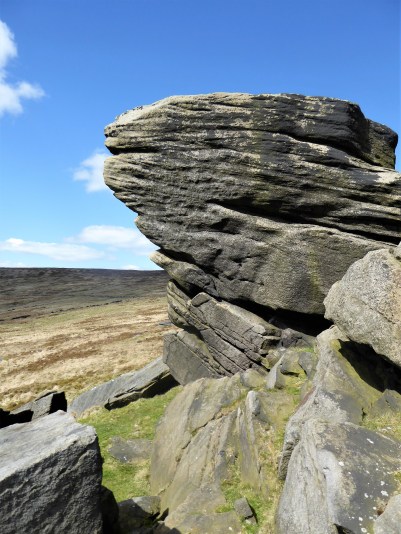
Stirring myself I was soon down to the dam. Mark’s route goes a little down the valley, towards the lower reservoir, before climbing again, but I spotted a level path getting to the same point by crossing, possibly illegally, the dam and using the estate’s shooters’ track. Not advised in the killing season. There were some very attractive little gritstone buttresses above that valley, I may need to return. 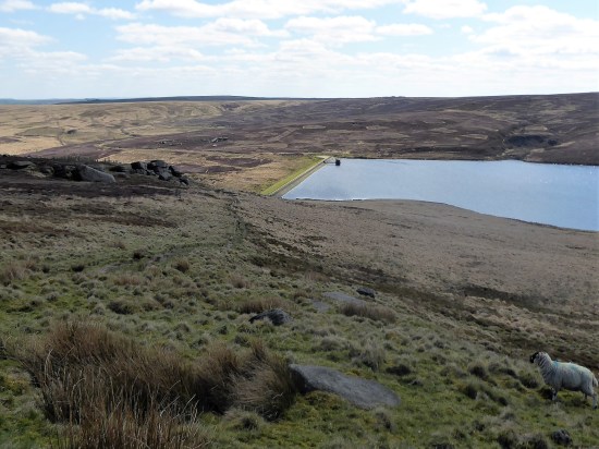


Gorple Lower Reservoir.
Across the way were the hauntingly fascinating ruins of C16-17th Raistrick Greave, presumably abandoned when the reservoirs were constructed, around 1930. It had been a large farm and buildings, one suggestion is that it may have been also a stop-over on the local packhorse trails. Reaps Cross is nearby and of course The Packhorse Inn over at Widdop. 

To be honest I never really picked up the path again. The ground is very rough and tussocky, when I thought I was back on track I usually ended up on a sheep trod going nowhere. I just battled up the hillside keeping to a southerly direction avoiding Clegg Clough for more than one reason. All around was that dry straw-coloured moorland grass so attractive from afar in the winter months. 
Boggy paths started to appear on Hoar Side Moor and I followed one until I hit the fence which I could follow westwards up Black Hambleton at last. All very bleak and isolated. 


The trig point eventually appeared. I found a rock to sit on straddling the Lancashire /Yorkshire boundary. All around were the familiar Pennine Hills. Bowland, Pendle, Ingleborough, Boulsworth, StoodleyPike and many unnamed ones to the south.Way down below I could see a Barn Owl quartering the rough pastures.

Pendle in the distance.

Bench marked rocky seat.
I wish the walk could have ended up here as I never found the proper path off to the southwest, the rough ground making it hard going, and the mile alonside the busy road was scattered with litter. But ignoring that last hour this had been a stunning walk of variety and remoteness, sorry I was distracted by all those boulders. I was tired by the end. 
***

A much much better effort than a dismal day for me on 18th August 2021 for three trigs of my campaign, including a very short ascent of Black Hameldon – see my post:
https://conradwalks.blogspot.com/search?q=Black+Hameldon
The highlight of that day was visiting the Singing Tree.
Well done with the wheatear.
I wouldn’t fancy Hoof Stones Height in those murky conditions, “For a couple of minutes I couldn’t find the path I had approached on” It is all too easy to lose the path.up there.
I could see, but not hear, the Singing Ringing Tree across the way.
That’s a great outing. I haven’t been up there as far as I can remember.
Not many have.
I’ve not been up there either. It strikes me now, after following your blog for a while, that probably all the remote crags and boulders I’ve seen will be well known by the climbing fraternity. The climb shown in the picture certainly looks impossible to me. Sounds like quite an adventure up there. Nice shot of the LBC. Looking good!
Climbers get everywhere – even places they shouldn’t. That climb has only had about five repeats in the last 25 years, suggesting it is extra hard.
Tough walk.
Wow, that looks a remote walk. With lots of wildlife. And some interesting shaped rocks and boulders. Love the lizard?
Presumably a Common Lizard.
Beautiful photos of the Wheatear and lizard. What a tough walk that was!
Thanks, Clare.
Quite an outing, thankfully the weather was perfect. I’m lucky I can choose my days, in fact thinking about it, I don’t remember walking in the rain for ages. Famous last words.