
I’m running out of titles for my series of walks in Bowland as set out by Mark Sutcliffe in his Walking In Lancashire book. He has certainly covered the area well. Highest, Best of, Heart of, and today Remote or even the Remotest… How many of you have been to Wolfhole Crag or Whitendale Hanging Crags? This is a long post I’m afraid – it was a long day.
I enjoy the familiar drive into the hills with the roof down. Along the Hodder Valley; farmers busy silage cutting in the fields; over the Roman road with views to Ingleborough; down to picturesque Newton; along to stately Slaidburn and up Woodhouse Lane to my parking place just before the fell gate. I say my parking place as it was a regular spot when we were developing the bouldering potential of Croasdale’s Bullstones all those years ago. Not many drive up this far, but Mark mentions the single space, there is a little more back down the lane.

Newton on the Hodder.
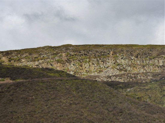
The hike up the rough Hornby Road, a Roman Road again, (aka Salter Fell Track) has been done dozens of times and I pass familiar landmarks. The war memorial to airmen lost on these fells; the ancient sheep folds and bothy down in Croasdale where I have stayed with my grandson; the culvert where one can still see the Roman workmanship; the large quarry where the peregrines nest; the bridge where the road has been saved from sliding into the valley; the Tercet stone demarking the Lancashire Witches fateful route to the assizes in Lancaster; over to the right the bouldering playground of Bullstones and later the vague track dropping into upper wild Whitendale. 


Along here somewhere I meet two RSPB workers checking on nesting Hen Harriers. It is good the birds have returned and let’s hope more survive the persecution by the shooting fraternity this year. No photos and as they say on the news “their anonymity and location have been protected” The road goes on over the watershed.
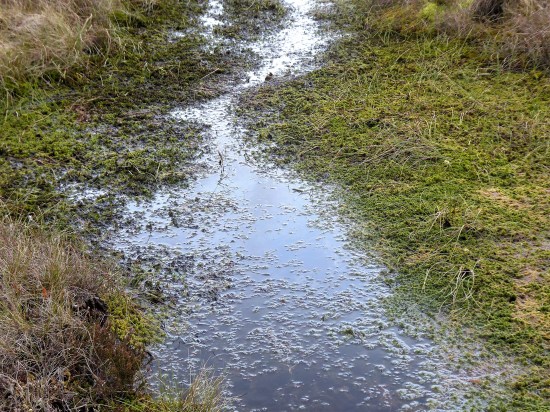
After four miles I leave the road for another four miles of mostly trackless and waterlogged ground. Mark says “the next stretch is very boggy and needs careful negotiation” Go no farther if you are unsure or if the weather is bad. This is remote country with no easy escape routes. My walking poles disappear into the mire quickly followed by my boots. Jack be nimble. It is not so bad – I survived. There is beauty there if you look closely.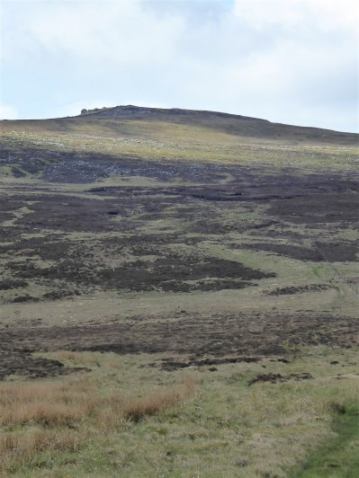


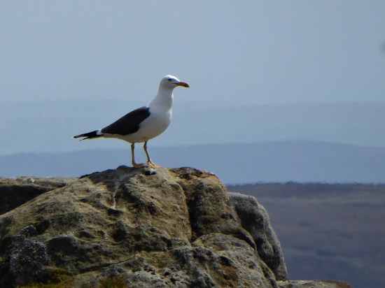
 If I close my eyes I could be at the seaside, the sound of gulls is everywhere. I think they are Black Backed, Great or Lesser?, a large colony exists up here. I try for a video, more for the sounds than the fleeting fly overs. They are becoming more aggressive, dive-bombing me. I look down and there below my feet is a scrape of a nest with three eggs. Better move on taking extra care where I place my feet.


It doesn’t take much to persuade me to take the ‘optional’ diversion to Wolfhole Crag half a mile away. One wouldn’t come this far in good weather and not go to the highest point. There is a trig point, 527 m, and also an interesting collection of gritstone boulders. I can’t resist a few simple boulder problems, keep them simple as you don’t want to break an ankle up here. The longer routes look fearsome. Somewhere there is a shallow cave in the rocks – the original wolf hole. 


A good place to eat my sandwich, wish that had been two as the day panned out. All around – The Lakes, Yorkshire Three Peaks and most of East Lancashire. Pendle is always visible. All a little hazy in today’s heat. 
Walking back down the fence line, no navigation needed, is not easy because of more bogs. Maybe it is better on the other side, No it isn’t I tried. White Crag is nothing but a few boulders. Whitendale Hanging Stones are not much bigger. But according to “the gravitational method to establish Britain’s centre of gravity OS calculated that the geographical centre of the British Isles, including Islands, lies at SD 6419 5654“ virtually where I’m stood. I’m too weary to take it in. In fact as I drop down very steeply I’m just too pleased to see the small tarn on the col between Brennand and Whitendale. The walls and fences aren’t too easy to negotiate. I lose even more height as I descend to the Duchy farm at Whitendale where my route ahead climbs back up zigzags for 800ft onto Dunsop Fell. 


White Stones.

Whitendale Hanging Stones, centre of Britain.

My way down.


Small mammal traps remind me I’m on shooting lands, the hunting class have some barbaric practices. 

I collapse onto a wall at the farm, nobody is about, I’m even wondering if I should phone my son for a cop-out evacuation, but a drink and a banana fortify me for the final stage. Thankfully once back on a stony trail my steps become stronger, and I push on up. The trail disappears into peat, but there are some posts and cairns to guide me to Dunsop Head, a vague col with a wall, gate and another of those crafted signs. Looking at the map and the terrain I realise I’ve never been on Baston Fell to the north, today is not the time to visit. Let’s just get down.

My way back up.


Looking back down to Whitendale with Hanging Stones above somewhere.


Go east across more bog. By the time Stocks Reservoir comes into view you are almost home and dry, although your feet are probably wet by now. Eventually the bridleway becomes more visible as a sunken way and the airmen’s memorial appears. There is my car down the lane with Pendle still watching over us. Seven hours of remote walking, one to talk about in the pub later.


***

I can feel my legs aching and my feet on fire after that. Remote and tough. Never been up there. I shall probably borrow that parking spot at some point. I did wonder if there was anywhere to leave a car towards the end of that lane.
£9 a day for that parking spot.
Must be National Trust then. 🤔
Gorgeous
Thanks, at times that wasn’t my thought. Yes in retrospect one of the best walks in the NW,
That wasn’t a walk, it was a marathon! Does it never bother you, being alone in remote terrain like that? I like the second photo, it’s a lovely clear view, and I’m glad you didn’t step on the gull’s eggs.
I suppose I’ve been doing it all my life. There is some inner satisfaction and challenge to those remote places, you need to know it to understand it. That wasn’t meant to be condescending. Maybe I should at least start letting my family know where I’m heading?
A fine walk. I’ve never felt more alive than in some of the remote places on my own, perversely in bad weather.
I agree but these days I try to avoid the rain.
All sorts of memories for me from this one. A splendid effort on your part and walking of the highest quality.
On 15 JANUARY 2013 I walked the first part of the Wyre Way with “gimmer” and made the following comment on my blog:
“A notable feature, for nerds only: a few kilometres north-east of our walk, is grid reference SD 6418 5654 close to Whitendale Hanging Stones, and appropriately remote. Somebody with a double degree in goodness-knows-what has calculated this to be the centre of the UK… including the islands!
https://en.wikipedia.org/wiki/Centre_points_of_the_United_Kingdom
but be warned; this not as simple as you might think.”
I wasn’t sure what I was the centre of, it all felt a long way from home.
That’s some walk! Reminds me I need to get up that way soon now we’re out of winter. I’m glad you didn’t get sucked into the murky depths!
An area with a unique atmosphere. (My offer of transport still applies if you want to do the through walk.)
I’m hoping to do it this year if my knee holds out!
Now you’ve reminded me I’m going to see if I can pencil in some options for a little later in the summer when work eases off but when the days are still long. Would need to be flexible to try and catch some decent weather. Which direction do you think would be the best?
Transport wise North to South. You could leave your car in or near Slaidburn and I would drive you up to the far end wherever you wanted to start from. All you have to do is walk back. I have an unfinished project up in Roeburndale to keep me occupied.
Great. I’ll get in touch when I’m ready to give it a go. I’ll give you some notice, of course!
Have you got my email address?
That walk looks so remote. I have been into the valley where the hen harriers are on a rspb walk a few years ago now. I couldn’t imagine navigating all that terrain you did on my own though. I think I really would let somebody know where your going. Maybe starting a WhatsApp group with your family might be a good idea, so you can check in on your walks or at least let folk know where your heading..
Pingback: BACK TO BOWLAND. | bowlandclimber