Tag Archives: Cornwall

SW COASTAL PATH. Porthcothan to Padstow.

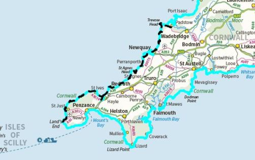
Leaving Porthcothan.

The last stretch.

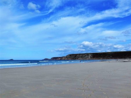
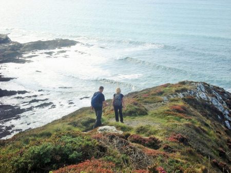
An interesting breakfast conversation with two Finnish ladies, mother and daughter, walking part of the SWCP, their English was of course perfect. There had been rain in the night but by the time I left there was no need for waterproofs, that’s 8 dry days in a row, and very soon the sky brightened. The headlands seemed busy this morning with people walking short stretches and using the connecting bus services. Between Porthcothan and Treyarnon the coast is deeply indented which meant lots of ups and downs but ever-changing scenery. The tide was high and in the wind there was quite a swell so all the little sea stacks were taking a bashing. In one narrow inlet the sea was being whipped up into a foam that was blowing up onto the tops just like snow.

Up here there were some good examples of ‘Cornish hedges’ which are really stone walls with plants growing in them. An ancient and lasting field boundary.

I was able to walk the long stretch of Constantine Beach on the sands. At the strangely named Booby Bay groups of bird watchers were focusing their attention on the rocks – all I could see were oyster catchers and gulls, not a Booby in sight.

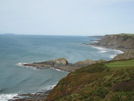
I made the full traverse of Trevose Head passing a very large blow hole where you could just make out the sea below without risking your life. Dinas Head seemed to stick right out into the Atlantic with some impressive sea stacks The Quies a mile out and another The Bull closer at hand.

The way continued past the automatic lighthouse and in the next bay Padstow lifeboat station relocated here as the Camel Estuary silted up. You can see from the photos how rugged and dangerous this coast is and the need for the light and lifeboat. In the past many vessels came to grief on this stretch.

I passed some drab looking holiday chalet sites which are probably deserted now, most people I met had rented cottages. After another headland Harlyn Bay was approached, rather than walk on the beach I headed inland to visit the pub for a coffee. Not the friendliest of hostelries I moved on quickly rather depressed by the area and the mist that had descended. I think I’d had enough so consulting my ‘map’ I could see lanes cutting across to Padstow and made the decision to head direct and celebrate with fish and chips in Rick Stein’s cafe on the harbour.  I arrived there only to find they had just closed at 3pm.  A bus trip to Bodmin for the night and I was able to sample the same fare in Bell Lane probably at half the price.

Padstow harbour.

I was last in Padstow in October 2017  so I have now completed most of my LEJOG walk [over the period of 50 years] I have only a few more days walking up to John O’Groats itself, watch this space.

*** *

SW COASTAL PATH. Newquay to Porthcothan.

Plenty of steps.

Today’s walk had the most ascent of any of the days so far and there were a lot of those steps to negotiate, I think they are worse descending than ascending.  After last year when I developed a hip bursa whilst doing long days on the coast I was more circumspect this time particularly downhill when I took things slowly. Of course the highlight of today was Bedruthan Steps themselves,  pictured above. On the beach here are several sea stacks which may have been stepping stones for the giant Bedruthan or more likely the name is more recent from the staircase of steps accessing the beach.  All that had me thinking of John Coltrane’s classic recording of Giant Steps which became my earworm for the day although a little too fast for my pace.   Go on listen and brighten up your day…

I had found a way down through the streets to a little beach near the harbour in the centre of  Newquay and then I had to find my way back up again, the start of todays steps. Trying to avoid the shopping centres I came across an old tram line taking me in the right direction. So I never saw the famed Fistral Beach. It didn’t take long to clear the suburbs of town, the intriguingly named Lusty Glaze cove was just a mass of commercial development but as I dropped into Porth the coast was again wild. There were a few early morning surfers out in the bay. Before a traverse of Trevelgue Head I sat chatting to a gentleman who backpacked with camping all the way from Minehead. He was beginning to think the b and b option might be more sensible.

The low clifftop fields I followed were the habitat of corncrakes apparently, no sound of them today as I presume they’ve flown. There were good views back to Trevelgue Head and Newquay and the beach below was interesting. I was walking parallel to the busy coastal road and I joined it when I dropped into Watergate Bay which seemed to be one large holiday complex, architecturally bleak. I stopped for an expensive coffee in a fairly nondescript cafe, another of those surfer establishments I’ve been critical of. I didn’t find escape out of the complex easy and ended up trespassing through a chalet park, it felt invigorating to be free again on the cliffs with a bracing easy stretch high above the beach. At one point dropping down steps to a cove I found a rocky platform just above the waves which gave an exciting snack stop. Waves crashing below and a distant horizon to contemplate the unknown.

Up more steps and before long and I was down again into Mawgan Porth another bay spoilt by modern apartment development. At least here was a quirky cafe, The Beach Box, with friendly staff where I grabbed a light lunch sat on their balcony watching the world go by. Why do surfers when donned in tight wet suits have to walk around like Tarzan? Time to get going.

Once across the beach I climbed back up to Trenance Point and enjoyed superb cliff walking in the best October weather you could hope for. The views along the coast were outstanding. Gradually I realised I was sharing the path with more and more people, I had reached the carpark area for the famed Bedruthan Steps.  There is a steep staircase going down onto the beach and today at low tide little figures were strolling on the sand between the rocks. It looks a classic situation to be cut off by the incoming tide and my landlady this evening confirmed that the rescue services were called out frequently, in her opinion the unprepared should be left to sit it out on a safe ledge for a few hours. Whatever, the scene is breathtaking.

Moving on the crowds disappeared as I walked over the grassy Park Head. A chough, red legged and red billed, seemed completely unconcerned by my presence as it picked around for insects in the grass. Apparently they were becoming rarer in Cornwall due to loss of grazed habitat but are now making a comeback, the NT use ponies and cattle on their land for this purpose.

One more valley to drop into and steps to climb out of and I was walking alongside Porthcothan Bay. The little shop where I expected to buy food was already closed so I walked up to my B and B in the handful of houses that comprised the village. What a friendly place to stay, the lady was a professional photographer amongst other things and a wealth of Cornish knowledge. She and her husband were retiring and this was probably the last night  for accommodation here which will leave a big gap for coastal walkers. She came to my rescue with a delicious Cornish pasty, thanks. I wandered out to try to get some ‘sunset over the sea’ pictures but was largely denied by a low bank of cloud. A lone surfer was returning from an evening session.

That seemed a longer day than the ‘Long Day’

*****

SW COASTAL PATH. St. Agnes to Newquay.

The Long Day.

Because I sold myself short yesterday I left myself with a long day today if I wanted to reach Newquay. Being a Sunday I would struggle with buses if I fell short. I used some little lanes out of St. Agnes to pick up the path up through the dunes as it swung onto the first headland where it ran alongside an old RAF airfield. In the war Spitfires operated from here but now only a few private planes, there were none today. The cliffs below were very crumbly and paths have disappeared into the sea. Again there was much evidence of previous mining.

The going was actually fairly level and I made good progress to Perranporth. There was a lot of new building work as I dropped down and some very expensive looking properties. In the car park a tea van promptly served me a decent coffee with no fuss for ÂŁ1.50 – take note those other cafes where a simple coffee order becomes a major catering event trying to justify the exorbitant cost. Of course I had to sit on a park bench.

Again I was lucky with the tide and able to walk along the Perran Beach rather than in the tiring dunes. I have never seen so many dogs being walked, apparently from September onwards they are allowed the freedom of the sands. The 2 mile walk was bracing in the wind, there were some interesting cliffs and the crowds thinned out the further one went. Climbing a steep path up the dunes and I was onto Ligger Point with great views back along the beach. From this lofty perch I was able to watch a kestrel hovering just below me. Kestrels have been a common sight every day on the cliffs along with ravens, choughs, buzzards, the occasional peregrine and of course the gulls.

Inland now was a military base with its surrounding security fence though it is no longer used.. Penhale Camp itself looked like a small village but again access was denied and one had to follow the perimeter fencing right round Penhale Point. There was agood view of some original Nissen Huts on the site. Despite the dreary nature of the camp the cliff scenery down to my left was dramatic.

I arrived in Holywell, with its beautiful looking beach, in good time and popped into the St. Pirans pub for a coffee taken outside so I could surreptitiously eat my own banana and biscuits. St. Pirans turns out to be the Patron Saint of Tinners. Cast out of Ireland he was washed ashore on Perran beach where he built a chapel.The legend goes that he discovered tin by accident – a stone on his fire leaking a white liquid.

St Piran's Flag

The Cornish Flag, the Flag Of St Piran (white cross on a black background) represents white tin flowing from the black rock, or good overcoming evil.

A text message arrived from tonight’s accommodation  asking my time of arrival as they were out from 5pm onwards, the instructions for picking up the key if I was late were so complicated that I decided to speed up and get there in time. That’s how I found myself lost in the middle of a deserted holiday park. Looking at my pathetic photocopy of a map I had reckoned I could miss out a couple of headlands and a mile or so by using a path straight across to Crantock. Public footpaths don’t do well in commercial properties or maybe I shouldn’t have been here in the first place and there was nobody to ask. For the first time this week the mist had come down perhaps shielding my indiscretions. Eventually I resorted to a compass bearing which saw me out of the camp but onto a golf course but again there was nobody arround. With some relief and a few fences climbed I came out onto the NT’s Cubert Common, lanes and paths had me back on route at Crantock Beach. The town of Newquay could be seen on the opposite side rising up from the estuary, a town of two halves with the other facing the Atlantic.The tide was still out which was important as I needed to cross the River Gannel at one of the low lying bridges to avoid a lengthy detour on roads. The first bridge I came to had been closed and apparently dismantled but fortunately the next one was intact and I crossed straight into the suburbs of Newquay. Some street walking with incongruous SWCP signs on lampposts took me up into town.

The missing bridge.

My way further upstream.


The owners of the B and B were surprised at my early arrival.

http://www.trelinda.co.uk/

*****

SW COASTAL PATH. Portreath to St. Agnes.

 A short day.

I enjoyed a leisurely breakfast chatting to a couple walking the whole coastal path to celebrate their retirement. They had every day planned out, accommodation booked and were walking like clockwork when they passed me yesterday. I’m not sure how much they were enjoying it as they didn’t have much to say about the scenery, wildlife or exceptional weather. I reflected on my attitude to long distance walking and when I was younger it was probably exactly the same, partly personality trait and partly the necessity of time restraints. Indeed we would choose a route no matter what length, within reason, divide the mileage into a week and do it, often entailing 25 miles a day: a race against the clock. My regular walking partner back then came to retirement and we set off on a journey across the Pyrenees with no time limit and no pre-booking, it was a revelation to him how it changed your outlook. We were able to do short days to start to avoid burn out, we had time to explore off route, time to sit out the worst of the weather, could change our plans when needed [in fact ended up walking in the opposite direction for the majority of the route] and best of all time to sit and enjoy the scenery and realise how lucky we were. Choose your own style. I won’t see that couple again as they race ahead but I hope they enjoy their last two weeks.

Today I opted for a short walk to St. Agnes, the mileage will remain short but it is surprising how the day itself lengthens.

I walked steeply up the road out of the village, the cliff path has been eroded so its best to keep with the road for longer until a signed path across a car park. Two blokes were enjoying the view before driving back to the midlands after a family reunion, they really seemed to appreciate the wild coast. A lady who had moved here from Sheffield 30 years ago was walking her dogs, she had an airbnb in Portreath. The dogs needed a wash after rolling in Badger excrement. The next encounter within a few minutes was a man who was down on holiday with his daughter when she had gone into labour ending up in Truro Hospital giving birth to a Cornishman, his first grandchild – I think he needed a brisk walk.

The path along the headland was separated from some military land by never ending fencing. A spooky dome appeared. Below were deserted beaches. Ahead were deserted tin mines, Wheal Tye, where some attempt had been made to preserve and protect with unsympathetic concrete. There were interpretation boards everywhere including a bold statement  –  On 13 July 2006 select mining landscapes across Cornwall and West Devon were inscribed as UNESCO World Heritage Sites, placing Cornish mining heritage on a par with international treasures like Machu Picchu, the Taj Mahal and the Great Wall of China. 

A steep decent into Porthtowan brought me abruptly onto a busy road and I was glad of a break at the cafe. There’s something about these surfers’ cafes that I’m missing, inexperienced part time staff,  basic  beefburgers and coffees at exorbitant prices accompanied by some indecipherable electro music. As long as they are near the action and there is outside seating then its OK.  At this one I ordered a coffee and croissant and after an inordinate time two croissants and the coffee arrived, I said nothing and whilst enjoying the fare a new waitress turned up with another croissant!

The penalty to pay was a steep uphill where I chatted to a lass originally from Sheffield out on a run along the coast in training for a mountain marathon. Apart from running she was keen on surfing and climbing. She sped off into the distance. Soon I was dropping down again into Chapel Port which was just a car park at the end of a lane. The car park was full yet more cars, mainly expensive 4x4s, kept coming down only to be turned around and sent away.  A steep pull and I was back on the bleak tops where there was more evidence of previous mining activity with a couple of atmospheric pump houses. Notice the mine shafts, topped with conical grids (known apparently as Clwyd caps).

I was crossing St. Agnes Head standing out into the Atlantic waves. There seemed to be an abundance of sea stacks on the coast here, one group curiously named ‘Man and his man’.  As I started the descent guess who should come past but the fell runner, she had done well over ten miles since I last saw her.

I didn’t have any reliable maps so out came my phone to navigate me into St. Agnes. without dropping me down to Trevaunance Cove which can wait till tomorrow. The village was delightful, winding streets, old pubs, interesting church, brilliant B and B [with a mining engine house in the back garden] and not least a good fish and chip shop.

http://www.enysvilla.co.uk/

Quite an interesting short day.

*****


SW COASTAL PATH. Hayle to Portreath.


Have you seen Poldark?

My most interesting encounter today was in the Godrevy Cafe above Hayle Sands. Two ladies, turned out to be sisters,  were looking for an outside table in the sun; I was just finishing my coffee so invited them to share the table. Conversation ranged far and wide and I outstayed my welcome. A chance remark opened up the subject of Poldark and the lady to my left explained she was the daughter-in-law of Winston Graham the author of the original series of historical novels. Her husband, the son, is involved in the TV productions and that very morning they had all been filming in a hidden cove on the south coast. No, she would not divulge any secrets but did say filming would be continuing on the northern coast this week. She was impressed that I had purchased a cheap plastic Poldark key ring for a fan back home.


The day had started by saying farewell to my lovely host in Penzance as I prepared to backpack up the coast. In 10 minutes the train had me in Hayle across the estuary and those busy roads where I’d finished yesterday. Hayle was worth an exploration for its maritime heritage and gave me the opportunity for some picnic shopping. Amongst the shops was a more chic ladies’ clothes outlet with a sign that amused me…Once across the harbour bridge I picked up the way through holiday chalets in the dunes and down to the beach as the tide was out. This then gave me 3 miles of flat walking with no navigating except to pick out the firmest sand, ahead was the lighthouse on Godrevy Island and across the bay St. Ives. There was a stiff Northerly wind blowing which made for brisk walking to keep warm. In the waves were lots of amateur surfers and bodyboarders who were mainly congregating at points where the lifeguards were on duty. Black cliffs loomed above the beach for most of its length but I found a way up, The Goat Track, at the far end which landed me in the said cafe.

The area was popular with dogwalkers and these three were ready in the carpark…Sand dunes, which can be heavy going [remember Herb Elliot’s training which led me to this very British video  clicking here.]  took me onto Godrevy Point with views down to the island lighthouse. In my experience where there’s a crowd there is something happening and so it turned out on the cliff top above Fishing Cove, the group of Exeter zoology students had spotted the seals in the bay.

The way onwards on paths through heathland was not difficult and most of the time paralled close to the road. The cliffs along here looked very crumbly and it was wise to stay clear of the edge particularly in the strong winds, strong enough for me to don a fleece for the first time this week. I felt I was making good progress until in the last mile I encountered two steep valleys with all the usual steps and zigzags. The descent into Portreath was punctuated by lots of expensive looking modern properties which I doubt if any of the local population could afford. The village itself looked a little drab in what is now classified as out of season. The pub next door to my B and B had a karaoke night so it was preferable to eat in my room.


Home

*****

SW COASTAL PATH. Zennor to Hayle.

The ‘busy’ stretch.

I was sat on a headland trying to observe seals on The Carracks, in earshot but out of eyesight, whilst a combination of sweat and suncream irritated my eyes and dripped down my face. I can hardly believe my luck, well there was a little planning, to be experiencing these perfect conditions at this time of year. Little boats out of St. Ives were ferrying tourists to view the seals at close quarters, certainly closer than I could get. I had encountered lots of people using the path today most were intending to get the bus back to St. Ives. Everyone was in a good mood enjoying the hot sunshine and the spectacular scenery. The stretch out from Zennor Head was however particularly gruelling with lots of scrambling on awkward granite rocks as well as the usual ups and downs. Over the years I’ve become more aware of the need for caution in these situations, thoughts of a broken leg ensure I’m no longer the mountain goat I once was. At least I’m better shod than many of the holidaymakers I pass although there are quite a few hardy backpacking types, mainly women for some reason; I think this type of walking on well-marked tracks in a fairly civilised part of the land enjoying good weather attracts them but why oh why do they have to burden themselves with those enormous rucksacs?

I had started the day in Zennor village where I had time to look around the little Norman church of St. Senara which was full of interest. It is most famous for the unique medieval Mermaid Bench with the mermaid carving on one end. There are many reminders of the sea in the church, indeed its roof is shaped like an upturned boat keel. Hanging from the roof is a model of a West Country schooner, created as a memorial to WA Proctor, who died on a solitary round-the-world voyage, and also to all unnamed sailors who were shipwrecked along this stretch of the Cornish coast. There is a colourful collection of hassocks made by the congregation many depicting coastal themes. The Burma Star window dedicated to WWII forces. A Norman font, a C18 sundial showing symbols of death [cross-bones] and immortality [an angel], celtic crosses and plaque to a John Davey [1812 – 1891], one of the last locals with knowledge of the Cornish language.


A friendly gent in a mobility scooter was manoeuvering himself down the track towards the sea, as I walked alongside I warned him that the path became much rougher but he seemed pretty determined, hope he made it back up. As you can see my departure from Zennor was delayed, by the way there is a cafe in the village as well as the pub. Once on the coast the going was fairly easy undulations and despite the roughness mentioned above I strode along enjoying every moment of the dramatic scenery. Up here in patches the heather and gorse are still giving a good show plus I’ve just learnt from mine host Rachel one can eat Gorse flowers which have a faint coconut taste. A good few of the serious backpackers were Germanic and I’m not sure what they made of my friendly how do and now then.  These two had the dog in tow for the whole trip.Passing a trig point where a lady from near my home town was in deep thought. A few more headlands and bays with Caribbean blue seas and St. Ives, from where most of the people had come, was in sight.The section I’ve been walking was relatively busy today, deservedly so, but from here on the crowds mass, ice creams are everywhere. people stagger out of the sea in wet suits and the pubs are packed. The Tate is passed, closing in 10 minutes, and little narrow lanes of former fishing cottages are navigated from one of St. Ives’ beaches to the other. I don’t have time for any of the art studios on every corner but was tempted by fish and chips. But I’ve still some way to go, surprisingly sylvan tracks by the railway take me first to Carbis Bay and on past the quieter Porth Kidney sands. I’ve had enough by the time Lelant railway station appears, there are some busy roads and industrial areas to negotiate around the Hayle estuary so I jump on a train back to Penzance.

Porthmeor Beach.

Porthminster Beach.

Carbis Bay.

*****

SW COASTAL PATH. Pendeen to Zennor.

The Granite Coast.

There are several magnificent granite climbing cliffs along this coast but none finer than Bosigran. I first visited here 30 odd years ago and tentatively climbed some easy routes. I returned a few years later on an extended climbing trip with my lovely friend Pete when we climbed every day for a fortnight. In those days I was ticking off routes in the Classic and Hard Rock volumes. There was plenty to go at down here, we were camped near the Logan Rock Inn at Treen on the southern coast but all areas were easily accessible and we roamed far and wide,  we visited Bosi a few times. One day choosing a time of lowish tide we were able to climb the full height [200m] of Commando Ridge. On other days we concentrated on the non-tidal main face, Doorpost Little Brown Jug,, Anvil Chorus all immaculate exciting climbs. Probably most memorable and subsequently tragically ironic was Suicide Wall with a scary traverse across the Coal Face and some very overhanging climbing to reach the top. I remember we rescued a young couple stranded on a ledge by giving them a top rope to safety. We had a wonderful time and today as I pass I reflect that I can no longer reminisce with Pete, God bless him. Surprisingly today depite the perfect weather there was no one climbing on the main face but a climber can just be seen high up on Commando Ridge.

This morning I had taken a late bus back to Pendeen for what should be a short day, first things first – a breakfast bap at Lillies next to the bus stop. I then started by cutting down some ancient lanes between lichen encrusted granite walls and coming across those characteristic stiles of cross pieces of granite, more like a hurdle.I was soon back on the coast and facing steeper gradients and the dreaded steps. High above me on the bracken covered slopes I thought I saw a working party clearing the path, but as I climbed higher realised it had been fell ponies doing the same job efficiently.

From up here there were views onwards to endless bays and headlands, but I keep remembering to look back – Pendeen lighthouse was a prominent landmark but yesterdays coast is a thing of the past. Inland on the rough hills the patchwork of cleared fields is also photogenic. It’s just great to be up here.

The coast was becoming more dramatic and the sea noisier and all of a sudden I was above Bosigran Cliff itself. The ghostly mines above were silhouetted against the sky and people were strolling down from the carpark enjoying the warm sunny weather. I sat for a while taking in the scene and rocky architecture.  I was then soon over the slope and on the switchback path high above the sea. The path was rather awkward through boulders and vegetation and was busy with coastal strollers. At on point I stepped aside into the rough to let a lady through. I muttered something about taking the rough to which she thanked me and as an afterthought remarked “I hope you are not referring to me” which brought a smile to my face.

Other rocky headlands were passed, a large group of children on some sort of adventure course on one of them, I hoped they were all roped on as it all looked rather chaotic. Gurnards Head and finally Zennor Head were places I’d climbed on.

Gurnard’s Head.

There were numerous descents into side valleys at sea level where a stream was often crossed using old granite slabs. This one has had the health and safety people interfering.Many of the sandy bays on this section of coast appear to be very difficult to access and I don’t think I saw anybody down there.

Time was passing quickly, I had a bus to catch and the ups and downs wouldn’t stop. I was glad when at the top of a steep flight of steps a little lane ran up into the popular little village of Zennor, I had no time for explore or visit The Tinners Inn and made for the main road with minutes to spare before my bus appeared. In my short day I had climbed over 2000ft in 7 miles.

Almost there…

*****

SW COASTAL PATH. Land’s End to Pendeen.

When tin was king.

This section of rugged coastline over the centuries has been the scene of intensive mining mainly for tin with some copper, silver and arsenic. The extrusion of granite into the area’s sedimentary rock produced extensive mineralisation. Surface mining is thought to have commenced about 2000BC when it was found that adding tin to copper produced the much harder Bronze. Tin was subsequently used in pewter and coins. The industrial heritage now on view dates back to the 16th century when underground mining as well as opencast developed on a large scale and reached its peak in the 19th century until a collapse in the price of tin and copper made it unprofitable.

The remains of pumping houses, crushing plants, winding wheels, open shafts, associated works and spoil heaps are found scattered all the way up the coast but are particularly frequent in the Pendeen area. Some of the workings went deep under the sea. The tin ore was crushed before smelting. What a sight it must have been when the industry was booming.The early bus from Penzance to Land’s End was full, my companions on the front seats upstairs were a couple from Canada on a grand tour. We marvelled at the bus driver’s skill negotiating the narrow Cornish lanes. As expected Land’s End has become a theme park and lots of tourists were arriving by coach for a morning’s visit and opportunity for some shopping etc.

I quickly bypassed the ‘attractions’ and headed for the most westerly point, Dr. Syntax’s Head, past several first and lasts. It was a beautiful clear morning but I couldn’t make out the Scilly Isles. The Longships lighthouse was however very prominent out to sea.

There were seals in the bay as I walked round to Sennen. A couple of rock climbers were just setting off for would be a perfect day on the cliffs, I was envious. Sennen Cove was busy as usual and a coffee in the cafe was hurried but the situation is magnificent.

The tide was low so I was able to walk across the sands, a feature that should last all week.

I climbed out onto Aire Point and followed the path easily to Cribba Point with a few of those dreaded steps. There was a zigzagging drop into Cot Valley and then a stiff pull up the other side.

An English girl was walking with a Spanish speaking lad, turned out he was from Nicaragua, and giving him lessons in English although he spoke well with an accent. I greeted him in Spanish and conversed for a short time. As they proceeded ahead of me I heard him say that I spoke Spanish like he spoke English, thought that was more of a criticism than praise.

Ahead was the hump of Cape Cornwall with its landmark chimney and lots of visitors. I didn’t go onto the point but chatted to the volunteer at the NT car park, a very friendly Annie, is it any wonder that I take so much time to walk short distances. 

Shortly after climbing up I was descending through gorse and bracken into the Kenidjack valley with its atmospheric ivy covered mining buildings.Climbing out the other side I tried to find the descent route into Carn Kenidjack where I did a classic climb, Saxon HVS 5a, over 20 years go with my friend Pete whilst on  a Cornwall trip. Today everything looked steep and dangerous, I didn’t have my climbing head on. More of that trip later.  Somewhere down there …

The next few hours were spent wandering through the old tin mines. In the distance was the prominent Pendeen Watch Lighthouse but by now I’d had enough and escaped up a lane to Boscaswell to catch the bus back to Penzance. On the way up there was a more modern mine, Geevor, which operated into the 90’s but now is a tourist destination only. Sat at the bus stop was an old bearded guy who remembered those times and was all to happy to chat about them.Not a bad start to my walk up the coast.

*****

BACK ON THE SOUTH WEST COASTAL PATH.

I arrive at Penzance station after a 9 hour journey, a journey that had only been decided on a couple of days ago. The weather forecast for the SW was excellent for the next week or so. I’ve unfinished business linking Land’s End and Padstow as part of my ongoing LEJOG completion. The South West Coastal Path is already in my thinking and I’ve even a map of some of the route.

An Airbnb is booked in town for four nights to get me started. It turns out to be 5 minutes from the rail and bus stations. Perfect. As I walked into the courtyard I was impressed by the artwork. It turned out my room was rented from an artist, photographer, author and forager extraordinaire. www.wildwalks-southwest.co.uk  It was fascinating talking to her about her exploits

A few weeks ago I was barely able to move never mind think of setting off on a rough backpacking trail. The tablets have worked and I’m here. So that I can monitor my progress without being overstretched I will do short stages to start and link them using buses from Penzance. If you look at the map it is all logical as Penzance occupies a central position transport wise in this part of Cornwall.

Setting off tomorrow…


SW COASTAL PATH – THE TV COAST.

Port Isaac – Padstow.

This is the ‘Newly wed and Nearly dead’ season according to the locals which explains the large number of tourists still out and about. The two villages linked have a high profile, Port Isaac is Doc Marten country and Padstow is TV cook Rick Stein’s domain, not without controversy. They are both pretty ports best visited in the evenings when the coach parties have gone. Boat trips and shopping have taken over from the fishing industry although local catches are still available but on the whole commercial tourism has taken over.

Walking through the sleepy village, without a sight of the Doc, I picked up a coffee and croissant and carried them up to a seat on the headland overlooking Port Isaac. A great place for breakfast on a sunny morning. The harbour was below me and looking across the bay Tintagel Head could plainly be seen. The first couple of miles was a real roller coaster with the path clearly visible ahead in the rugged scenery. Varley Head and Kellen Head were crossed on muddy paths slippy from yesterdays rain.

Round the corner the inlet of Port Quin was entered. People were parking up and heading for the coastal paths unfortunately the mobile tea van hadn’t opened yet.

On Doyden Point was a folly built by an 19th century merchant to entertain his friends. Nearby were two fenced off mineshafts, previous silver mines. Vapour was rising from one of them and on peering down the sound and smell of the sea came up, the shaft had obviously reached sea level maybe 25m down.

A little further I had a break by a dramatic sea arch, Lundy Hole.

Grassy paths wandered through gorse and people seemed to be coming from everywhere, looking at the map I realised there were many circular walks from nearby Polzeath. A gentle circuit of the rocky Rumps Point and Pentire Head gave good views of rocky islets with speed boats whizzing around. From the point i could see right back up the coast to Hartland Point and Lundy.

Then I was into Polzeath on Hayle Bay with the usual surfing crowd in the waters.The first cafe I came to was in a side street, an old fashioned establishment with home made drizzle cake.The elderly couple gave me a sample of rocky road cake which I’d never come across, very rich and chocolatey. Apparently popularised by Nigella Lawson – another TV link. Next door was a beach house based on an old railway carriage. Third class strangely from the Rhondda and Swansea Bay Railway closed in the 60’s.

Walking past seaside houses I arrived on the beach of Daymer Bay the site of the treacherous Doom Bar now famous as the name of one of Cornwall’s beers. There were lots of people strolling along the beach but as the tide was coming in I kept to the higher signed path up through the sand dunes for a final flurry to the quay at Rock. The small ferry to Padstow arrived and before I knew it was elbow to elbow with tourists shopping in the narrow streets. I had a bus to catch so will leave exploration till next time.

Accommodation was expensive in Padstow so I’d booked into a pub in nearby Wadebridge from where my 10 hour journey back to Lancashire would begin tomorrow. Eight great days of coastal walking are behind me and the legs remind me of the strenuous nature, time for a rest. Not sure when I will be back to finish to Lands End.


SW COASTAL PATH – AN EXHILARATING DAY.

Tintagel – Port Isaac.

The forecast was dire – rain by 2pm and wind all day. So I set off expecting the worst, you never think about not going. Within 20 mins I was hiding behind a wall at the clifftop YHA putting on full waterproofs. The wind was ferocious and I was very wary of getting too near the cliff edges.The start of the route was above slate quarries and wet slate was not the best footing.

Slate quarries and Gull rock.

Approaching Trebarwith Strand.

On reaching Trebarwith, all of 2 miles, I dived straight into The Port William pub for a coffee out of the wind. Quite an expensive place to stay in, the chatty barmaid said in a whispered voice that you paid over a ÂŁ100 for the view, obviously way out of her budget. She had walked parts of the coastal path and wanted to do more.

From the steep steps behind the pub I could have a breather and watch the waves in the bay.

There was more evidence of slate quarrying in the next valley.

The route continued in the same difficult manner in and out of small coves. The wind made it difficult on some of the exposed ridges and I was glad to take shelter in one of the bays just above the pounding sea. 

A small snail hitched a ride on my rucksack and another had to make its own way.

Back into the wind and rain I battled over more headlands whilst the waves crashed below. I was beginning to enjoy myself. Port Isaac could be seen ahead.Reaching a road I walked into the little harbour of Port Gaverne, i was dripping wet and didn’t feel I could go into the many starred hotel. So I pushed on into Port Isaac and found a quiet cafe in a side street for my favourite toasted teacake and coffee.

Ignoring the rest of the village I just wanted to get to my airbnb and have a bath. The Coop provided a cheap supper as I couldn’t be bothered to go back down to the restaurants.


SW COASTAL PATH – NO EASY DAYS.

Crackington Haven – Tintagel.

Today’s plan was simple – enjoy a good early breakfast, climb the high hills over to Boscastle where I’d lunch in a cafe and then enjoy the afternoon’s stroll into Tintagel. Somehow I staggered into my hotel at 6pm.

As usual the first obstacle of the day was a steep climb up a headland – why did I eat such a large breakfast? Looking back though revealed the amazing convoluted strata of the cliffs at Crackington.

Onwards up to the highest cliff in Cornwall where the only bench for a rest and the best view was occupied by a lady. She happily shared it and we exchanged conversations far and wide. She was walking to Boscastle where she had left her car. Not wanting to interrupt her day I wandered on but as I was always stopping to admire the views and take pictures we kept passing each other.

A little further and she was taking lunch, she warned me about some steep sections before Boscastle but I continued expecting an early lunch. She knew something I didn’t. It was a beautiful day and there was lots to see and yes lots of climbing. The feral goats on Beeny Cliff appeared on schedule ready for their photo opportunity. More than one ascent of 200 steps had me puffing. 

Eventually I dropped into Boscastle. What a shock, packed with tourists and gift shops. The cafes by the quay were all full so I walked into the village and found a less twee place who did me beans on toast.

Leaving about 3pm I met up with the lady again as she walked out of the port to collect her car, she wished me well for the ‘short’ stretch into Tintagel. Motto, Always listen to the locals. I missed out the diversion to Willapark headland with its white lookout post. Valley streams were crossed on footbridges, steps climbed and rocky sea stacks seen. Ahead was the headland at Tintagel, the castle I could see was a hotel not the famous ruins.

A feature along this stretch were the Cornish walls of well crafted stones often in zig zag patterns, ‘curzyway’.

Passing a prominent caravan site I started meeting people walking back from a day in Tintagel they had varying estimates of the distance I had to go. First into the steep attractive Rocky Valley with its stream heading to the sea and then another dip with steps, I never seemed to get closer. Perhaps I should have taken a short cut into the village but I found myself back on the beach under Tintagel Head. The castle grounds were closing for the day, all was Arthurian but there is little to substantiate the claims but who cares in the pursuit of commercial tourism.

A trail up to the village and I was installed in a room in the appropriately named The Cornishman. It was soon dark, there are no easy days on the SW path.


SW COASTAL PATH – A BUSY STRETCH.

Bude – Crackington Haven.

The bus services between some of these Cornish villages is fairly regular which may explain the number of people enjoying this stretch of the path today, the weather was good too. First thing this morning I was drawn by the aroma of freshly baked bread into a bakery for a coffee and pasty. I was not impressed with Bude last night but this morning as I wandered out through the old town and past the canal area things improved. I passed The Bude Light, which is illustrated on the OS 190 Map cover, a millennium project to commemorate an early oil lamp invented by Sir Goldsworthy Gurney in the mid 1800’s. Apparently this multicoloured monument is lit internally at night, shame I didn’t realise.     After a long chat to a sprightly Octogenarian I began the climb up to the prominent Storm Tower on Compass Point. This gave a view back over Bude Bay to yesterday’s walk and views ahead to more and more headlands.

To be honest the walking this morning to Widemouth Bay was easy, more Downlike than rugged Cornwall. A road ran alongside and I was soon walking through car parks in the bay. there wasn’t much activity in the sea but plenty of dog walkers out. They all seemed to head for the cafe I took morning coffee in, the result was chaos with constant barking and unruly dogs knocking over tables and drinks. The walk now changed character with some of the steepest sections I’d come across, unrelenting all the way to the end. There wasn’t much happening in sleepy Wanson where I took to a steep road for awhile. A couple of blondes in an open top Merc stopped for a chat to pass the time. Back on the headland path I met a man walking the whole LEJG route, he was taking short cuts and diversions away from the coast to make his journey easier. Up here a couple of parapenters were making the most of the thermals. They had views back over Widemouth Bay and even distant Dartmoor. The only place to sit for lunch was on a stile and this prompted a steady stream of walkers to disturb me. Several were staying in Bude and having forays each day onto the coastal path using buses to link up. A family were making slow progress because of the father’s knee problems, the steep ups and more so the downs are not knee friendly and this section had some really steep climbs. There was a green interlude at Dizzard in oak woods, this is NT land as are many sections of the coast which I had forgotten to mention. Then three more headlands and valleys to negotiate, I lost count of the number of steps.From the last high point, Pencannow, Crackington Haven eventually came into view and a lovely rake took me down to holiday cottages and my hotel for the night. The tide was out and people were enjoying teas in the cafes before departing. That is the good thing about this path and finding accommodation on it – in the evenings the places revert back to their quiet existences.


I’ve met some lovely couples today all enthusing about this coast. It is good to see so many people out walking and appreciating our national heritage.  The stairs up to my room, the final steps of the day, in the Coombe Barton Inn were creaky and my room a bit lopsided. I’m looking forward to some good Cornish beer and food.


SW COASTAL PATH – SOUND OF THE SEA.

Morwenstow – Bude.

A leisurely breakfast was taken after the night before [beer festival]. I was in no rush to leave the comfortable pub as it was misty and forecast to rain. Faff and talk. Waterproofs on from the word go. Once I was back on the coast the ups and downs started but I was in mist and could only have glimpses of the coast, no idea what was happening inland. There was no wind only a strange world of silence, just the sound of the pebbles on the beach being washed out to sea and then back in again. In this silence was the background sound of bird song – most of which I don’t recognise. Eerie.

The slabby climbing areas of Higher and Lower Sharpnose passed mostly unnoticed.

Next thing I was face to face with a high security fence with dire warning notices. I had lost the path and stumbled into a GCHQ listening compound. There were radar domes and dishes which pointed east and west, I guess we are in the middle now, Trump and Kim Jong-un. I retreated to the coast.

In the mist headlands and valleys came and went. There were views down to distant beaches and all the time this strange silence.Relief came in one of the valleys, Sandymouth, in the form of a great little cafe but I managed to spill most of my tea.The terrain evened out but not much of Bude bay was seen till the end as the mist slowly cleared. Looking back along the coast was dramatic. Beach huts announced the arrival of the seaside holiday resort with a few hardy souls on the beach.

Bude looked grim as I walked in with wet and dreary families heading home, my hotel was even grimmer.


SW COASTAL PATH – INTO CORNWALL.

Hartland Quay – Morwenstow.

A cliff top walk of the highest calibre. I had been warned about the section from Hartland to Bude, 16 miles and 4500ft of ascent/descent so taking my decrepit state into consideration I looked for alternatives. The map showed a PH at Morwenstow, half way, and phoning them I secured a bed for the night. The only problem the landlord warned me of was that they were hosting a beer and cider festival – even better but that’s another story.

The morning at Hartland Quay was perfect, the previous nights storm had vanished and I enjoyed a pre-breakfast stroll to admire the dramatic coast. Visible distant headlands would soon be reached but it is what they hide that makes the SW path challenging. Side valleys  coming from the hinterland contain lively streams cutting down through the cliffs, often ending in a waterfall onto the beach, giving so much character and diversity to the walk. I wanted to explore all these enchanting valleys inland – so little time. Today there were a lot of these. In one of the first campers were scrambling down to the beach for some early morning surfing.

After that there was a good level cliff top section when I had time and breath to admire the views back to Harland Quay and Lundy, there was even a perfectly placed picnic bench to have a snack whilst doing so.

Then the ups and downs kicked in with lots of steps. Somewhere along here was an old coast lookout dedicated to Ronald Duncan a local poet who lived nearby, 1914 – 1982.

And then into Cornwall, or Kernow its Cornish name. Recent strimming from here on suggests Cornwall has a higher priority or budget for the path than Devon. The spectacular scenery continued and looking back Hartland Quay was still visible as was Lundy Island.

After more steep valleys the church tower at Morwenstow came into view but first I had to visit Hawker’s Hut. Parson Hawker occupied the vicarage from 1834-74 and being the eccentric character he was built himself a little hut from driftwood, here high on the cliff he would contemplate the Atlantic. I spent some time doing the same.

A path led into the village by the vicarage where Hawker had erected chimneys representing the steeples of his previous churches. The Norman church was just above.

Then a path led me directly to the Rectory Tea Rooms where a Cornish cream tea was indulged in, well you have to.

I then made my way to The Bush Inn  for the night. A traditional inn which hasn’t changed much over the years; possibly, along with others, one of the inspirations for Jamaica Inn. Murderous wreckers were common on this coast. Oh and did I mention the beer and cider festival?