
Dutton, like Mitton, is a scattered community, a few houses here and there. It is bounded on the south by the River Ribble and stretches high up onto Longridge Fell.
This evening, recently the days have been showery but the evenings sunny, I wanted to explore again the gorge-like Duddel Brook which runs through the middle of Dutton. Since I was last here I have read a little more and found some old maps of the area necessitating another visit to examine the Dutton mill remains. On one map it is labelled as a Bone MIll which suggests to me grinding bones to manufacture bone meal but another source implies a combing mill, comb as in cotton spinning rather than hair care. Perhaps it was both at different periods. Whatever, there is a weir, a mill race or leat, a millpond and a wheelhouse to be discovered.

OS 1892
My path through fields is clear and soon I enter the wooded valley and come across the wheelhouse. Above is a large mill pond partially silted in. From there I can trace a mill race above the stream to a weir where the water was diverted. All very plain to see.

Wheel House.

Wheel pit.

Millpond.

Mill race.

Mill race.

Mill race.

Weir.

Weir and start of the race.
My way onwards up the valley crossed a footbridge and climbed high on the western bank before dropping back down near a waterfall where the water was forded, there were no stepping stones. All very delightful.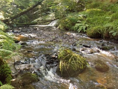

Back out in open fields hares dashed away in front of me. I came out onto the main road near the junction with Gallows Lane. One of the ‘slate poems’ that have appeared during lockdown was propped up here.
I crossed the road to a driveway and followed it down past the barking dog at Grindlestone [grind stone] Farm. The track was bordered by an old iron railing usually the sign of an estate boundary. If I had continued I would have come onto the Ribble Way into Hurst Green but I turned off at an unsigned and apparently little used bridleway.

From up here, there were views down to the River Ribble at Sales Wheel. I found it difficult to find the way through the copses but then picked up white markers taking me to the Ribble through Dewhurst Farm with its piles of logs for firewood.
A nice little path through meadows brought me out onto Gallows Lane near those picturesque cottages of Lower Dutton. The origin of the name of the lane possibly goes back to the days when serious miscreants were tried at the town courthouse in the White Bull, Ribchester, and taken to gallows at the upper end of the lane, A sobering thought for maybe stealing a sheep.
*****

The red arrow marks the mill.
It’s a pity more of these remains aren’t restored, but even so they have a charm and ambience in their present state. A worthwhile expedition.
You can’t save them all.
You have the Heron Corn Mill preserved.
But it would be good if there was more information readily available about them.
amazing how much nature takes back what man once deemed important.
Nature usually finds its equilibrium if left alone.
Thank you, thank you, thank you. Just fabulous to have these photos, the map and the history. I can’t believe that I never saw these things in all the years I had in Dutton. Wow, what a wild place to build a mill too, with very little flat land for the building! Presumably, the work force was very local, and arrived there by footpaths up and across the hill. It must have been often a very unpleasant walk through the mire when the weather was bad. The mill must have been built in the eighteenth century….do you think?
I’m thrilled to see this site at last, as there’s no hope now ‘in the real’. The photos are all great, and really clear. Thank you so much for explaining each picture. I can’t thank you enough for sharing this walk, and for battling the underbrush, not to mention the midges! Thank you.
I enjoyed that trip back to the valley. Knowing what I was looking for made a big difference.
The little ford below the waterfall higher up is a magic place. The stepping stones have long gone, these becks can be ferocious in flood.
I hanker a desire to follow some of these stream beds direct as an adventure when the water level is low. I may have missed my chance earlier this year in all that good weather but I wasn’t going far at that time.
The track that took me into the mill vicinity started from the road just above the cottages at Lower Dutton. It was a gentle incline so I presume would have been used for goods to and from the mill.
I couldn’t find much more written information on the mill. The old maps are a good source of info though. I may speak to Mr Penny at Dutton Hall sometime, he may know more.
If you ever wanted the pictures I could send the originals by email. I loose resolution when I post them in my blog.
Regards.
That’s so very kind of you. Yes, I’d love to have the pictures by email. Thank you so much. I’ve sometimes looked at the footpaths that come from Duddell Farm across the field to meet Gallows Lane, and have wondered if that was where the mill was sited. It’s great finally to find the exact site (courtesy of your hard work!). I didn’t think a mill could ever have been built in the Manor Woods, as, above the house, the stream is very steep-sided. There is a very overgrown quarry there, where the stone for the house came from. Actually, it’s a bit treacherous, and very dark. Very gothic and gloomy!
I love your pictures. I left Dutton in 1982, but the whole of the Ribble Valley still tugs at my heart.
Thank you so much.
If you want any of the pictures just email me on johngproud@hotmail.com
That quarry sounds interesting.
I like the waterfall, it looks very picturesque 🙂
The whole valley is magic.
I’ve said before I would like to follow some of these stream beds and waterfalls up the valleys. A bit of an adventure if the water levels were low.
Another great expedition. I know the Ribble a bit just upstream of here, as far as it’s junction with the Hodder, then up the Hodder to Stoneyhurst. Wonderful landscape. This looks like a great extension.
My main aim was to document in photographs Dutton Mill. I’m fascinated by these old ruins but find it difficult to imagine life in these parts 200 years ago.
The Hodder is one of the most underrated rivers of the NW. Did you see the BBC programme, River Walks, about it a year ago.
I missed that one. There’s a circular I do from Hurst Green that takes in the college, then picks up the Hodder at Over Hacking wood, then downstream, to the Ribble and back towards Hurst Green. I love the landscape around there.
That walk has now been given the title of ‘Tolkien Trail’ and has been very busy during the lockdown.
I touch on it in my latest post.
Yes, I noticed you you posted that one this evening. Looking forward to reading it. It’s been quiet in the past when I’ve walked it, but these coronavirus times are making it difficult to find some space.
We crossed Duddel Brook higher up yesterday, in the wood of Dutton Manor. Just below the footpath is a lovely stone footbridge with the initials POWW and a date stone of 1905. Does anyone know anything about it? It doesn’t seem to be on a footpath…..
You must have been a bit of ‘off track’ exploring to find that bridge. No idea on the initials, somebody in Hurst Green or Stonyhurst historical archives may know.
We’d walked from Squire House and New Row to Dutton Manor wood. There’s been a lot of clearing in the wood, so was no need to go ‘off track’, it was perfectly visible from the driveway 🙂
Oh, I know that path as it crosses the drive to Dutton Manor. I’ve never had the nerve to walk up the drive to the house, tempting though it is.