Tag Archives: Macmillan Way

SOMERSET – meandering to the coast.

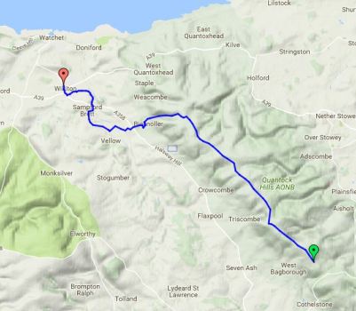
Williton – Minehead.

It was bright but there was still a cold easterly wind blowing as I left Williton. The sandstone church on the edge of town seems much younger than most of the Norman churches passed so far. A little lane was signed to a Bakelite Museum, outside the building were random exhibits – miniature egg shaped caravans, bikes,etc. Unfortunately it didn’t open till 10.30 so after a quick external peep I was on my way. The paths hereabouts seem to be part of an estate with walled sections and bridges over driveways. The lanes in the area have a reddish tinge to them caused by the farm vehicles from the red clay fields. The way was undulating to say the least with constantly changing scenes, tiny hamlets dotted the landscape, compass work was needed to navigate the network of unsigned narrow lanes. On paths, often the Macmillan Way, the vegetation was already high with nettles, the shorts I’d been tempted into today didn’t seem such a good idea now.

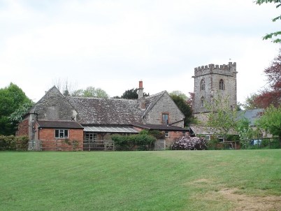
I arrived in Withycombe ready for a rest but was attracted to the squat towered church. To my surprise inside there was coffee and tea making facilities available to visitors so I enjoyed a sit down and refreshments. Thank you. The interior itself was interesting with some fine woodcarving. Two stone carved effigies, one of a lady with a dog at her feet and one of a man wearing a hat. There were also 15C stone carvings depicting ‘green man’ – these figures are apparently common in SW churches  All in all a worthwhile stop.

Effigy with dog.

Effigy with hat.

One of the Green Men.

I found a sign pointing up a lane, Dunster 2½ miles via Withycombe Hill. Soon I was up on top with views to Minehead, the Bristol Channel and into Exmoor, and behind back to the Quantocks. Further along the ridge was Bats Castle an Iron Age fort whose ramparts and ditches were clearly visible.

The Quantocks of yesterday.

Bats Castle and distant Exmoor.

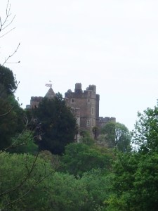
I was glad to loose height out of the cold wind into forestry on the edge of Dunster. Until now I had seen nobody all day but suddenly there were car parks, signed ways and hordes of people. Dunster is a picturesque village with the added attraction of its castle. First though a visit to the Chapel House Tea Rooms for cheese scone and tasty tomato chutney, cream teas seemed popular with other tables. I wandered through the crowded streets and into the castle grounds but felt I didn’t have enough time for the castle itself so don’t know what I’ve missed.

I was keen to find lanes taking me to the coast for the last few miles. The tide was going out so I enjoyed an exhilarating walk along the sands rather than on the golf course above. All to soon I was passing a busy Butlins complex and checking into my cosy B and B in Minehead.


ALONG THE QUANTOCKS.

West Bagborough – Williton.

Thank you Charlie, from Bashfords Farmhouse B and B, who gave me a lift back up that steep lane to Birches Corner to continue my progress along the Quantocks. I find I’m following a waymarked Macmillan Way West from the car park. A couple are just emerging from their van having slept up here, they are on their way back to Cornwall after a trip to Glastonbury to buy a brimmed hat for him. Three ladies set off with their dogs on a school reunion weekend, I follow discretely behind their nonstop chat. This is proper open heathland, yellow gorse and skylark country. Additionally beech trees border what must have been an old drove road. There are tracks everywhere but it is simple to follow one along the crest to the highest point, a trig point at 386m, curiously named Wills Neck. The visibility is poor unfortunately. Onwards easily along the undulating crest for another three miles or so with that freezing wind behind me. Lovely wooded slopes and valleys drop off both sides.

My way down Bicknoller Coombe could easily have been missed, there are no signs. Once out of the wind I stop for a snack, a cuckoo is heard [first of the year] and then seen in a nearby tree, buzzards fly overhead and sounds of a whistle from the steam railway below drift up. A small stream is followed all the way into Bicknoller village, some lovely little thatched cottages with tidy gardens, wisteria and roses complete the ‘English’ scene. A particular climbing rose with tight small yellow flowers is popular, I was not aware of seeing it before – probably Lady Banks.

I walk straight into the community store and order a coffee which is enjoyed in the sunshine. Just about everything can be bought in this little shop run by volunteers, hope it survives. As I walk small lanes through agricultural land I hear an approaching steam train and arrive just in time to see it pass. This is the restored West Somerset Line running over 20miles from Minehead to Bishops Lydeard run again by volunteers. I notice signs for The Coleridge Way, a feather quill pen, he wrote some of his major works whilst living in this area of Somerset.

The next village Sampford Brett has more picture postcard cottages and an unusual orientated

Church. A few fields later and I am entering the busy little town of Williton and booking into my comfortable accommodation for the night, the Mason’s Arms.

Macmillan Way West.

Coleridge Way.

FASCINATING RURAL SOMERSET.

Bridgwater – West Bagborough.

I used quiet country lanes for a couple of miles, my attention was drawn to the roadside flora which was a few weeks ahead of our northern lanes.


Ragged Robin.

Horse Chestnut.

Hawthorn.

Comfrey and Cow Parsley.

I entered North Petherton via a series of alleyways and was unexpectedly confronted by a magnificent church. A 15th century minster with a highly decorated tower, Inside are some fine wooden furnishings and a replica of a gold Alfred Jewel said to have been found after the dissolution, the original is in the Oxford Ashmolean Museum. Opposite the church was a perfect little coffee shop – Truly Scrumptious – it was.

I now started climbing towards the Quantock range of hills, an area I had never explored. Kings Cliff woods were popular with dog walkers, the cliffs of sandstone looked very precarious. Oak and beech woodlands followed the steep valley running west to east, the bluebells were spectacular. Slowly I gained height in the valley and it opened up into farmland with some exclusive properties scattered on the hillsides.The stream coming down the valley had been dammed in many places to produce ponds and mill races. I spotted a fox walking towards me but despite my stillness he ran off before I could get a decent view or photo. At the top of the valley was the village of Broomfield and the NT Fyne Court. There is much to interest you here – an old church, schoolrooms, estate houses and the remnants of the estate. The estate was owned by the Crosse family whose most famous son was Andrew, the mystical ‘thunder and lightning’ man,who in the 19th century carried out complex electrical experiments using wires strung out through the trees in the estate.Little is left of the property which burnt down in 1894 but the NT have a wonderful little cafe in one of the surviving buildings. If you like home made cakes and scones this is the place! Whilst chatting to the staff I was given helpful instructions on how to proceed for the afternoon without having to loose much height. I took these with a pinch of salt as they only recognised  walking on roads and I didn’t want to miss Cothelstone Hill.  I was given a lovely hand penned map to help me on my way. But first I would explore some of the well marked trails through the estate – embarrassingly, I managed to get seriously lost! So I thought after all that their helpful advice could be useful and followed their more than adequate map along quiet, twisting  and undulating lanes. I found the path going off to Cothelstone Hill,332m, and was soon walking up open heathland. Exmoor ponies graze this area and they were posing for photographs at the Seven Sisters beech plantation  towards the top. There were good views down to the Bristol Channel, Wales and the Minehead headland. I passed an obvious burial chamber and then headed down through bluebell woods back to a road, Following my paper map I was soon heading steeply down into West Bagborough on the edge of the Quantocks. I’ve thoroughly enjoyed today’s variety.

I enjoyed an excellent B and B at Bashfords Farmhouse, they took pity on me as I was now in the middle of a nasty head cold – a long luxurious soak in their large bath.

The local pub was overrated and expensive, this is very much a riding and hunting area.

BACK IN SOMERSET.

Last year  http://bowlandclimber.com/2016/08/16/somerset-ways/  I started to fill in missing sections of ‘my’ LEJG trail, then I was heading N to Bath this time I’m heading SW. I find myself back in Bridgwater a rather seedy town I do not take to – everyone to their own. I march past my previous unsavoury lodgings and connect up to a canal, Bridgwater to Taunton,  heading wisely out of town. It is a couple of miles walk to my B and B for the night, it is a pleasant evening and soon Industrial sites are left behind and rural scenery takes preference. There are more cyclists than walkers as the towpath is part of the national cycle network. An old bridge takes me across to the canalside Boat and Anchor.

The forecast is dry for the week but a cold easterly wind is blowing – I had thrown in an extra fleece.

My map shows several paths going in the appropriate direction for the next few days, I can mix and match  Macmillan Way, Somerset Way, Coleridge Way and eventually the SW Coastal Path.

View from Boat and Anchor bedroom.