 Dull and misty this morning, so I was in no rush to get out. Enjoyed a lazy breakfast with one of my sons who is staying over. He intended a cycle ride over Longridge Fell and round the local lanes, I didn’t feel I could keep up with him so I set off for more of the Wyre Way.
This time I had a decent scaled map showing the route and I was determined not to proceed without a WW sign. Things went well out of St. Michael’s on a good path by the River, well-used by dog walkers. For some reason the signs soon had me back on the main road for a noisy stretch, motorbikes ++, before rejoining the river bank. Surely a better way could be negotiated nearer the river. Himalayan Balsam has taken over on the river banks on this stretch.  I was glad I hadn’t stripped down to shorts yet as the path vegetation was quite aggressive, though at one point near Land House farm someone had done a good stretch of strimming, thank you. The village of Churchtown provided a pleasant diversion with its church and old houses.
  Between here and Garstang I felt I was in ‘no man’s land’, quiet country lanes and field paths either side of the A6. Glad to see one farmer clearing up the usual junk into at least one pile.
 Nothing much moved, not even the gigantic wind turbine at the cheese factory which is a prominent sight whilst driving the A6 north of Preston.
 The way creeps up on Garstang and you suddenly find yourself on the Lancaster Canal by a small basin. Here there is a tempting pub, on this hot day, unfortunately on the wrong side of the water.
 The Wyre is rejoined by climbing down steps from the canal at an interesting Aqueduct.
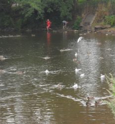
 Soon, one is in Garstang’s [advertised as the World’s first free trade town??] main street. A small diversion would take you round the interesting parts of this attractive market town, but as I have done precisely that many times I took the early turn off to the riverside path again. This path is a favourite of the residents and visitors alike, and today was busy with families enjoying the weather. Ice creams were being consumed, a cricket match was in progress, kids were in the shallow waters and lots of dogs were being exercised.
 As one leaves the town a newish flood barrier has been developed. To prevent flooding further downstream in Churchtown and St. Michael’s, this can be closed and the excess water fills the flood plain above.
 On a day like today this area is open fields with pedestrian access providing good leisure facilities and a sculpture trail.
 The Wyre is by now reduced to stream size. The railway and M6 are crossed quickly ….
 ….and then leaving the river, an old cobbled path leads through woods to the outskirts of Forton with its prominent Church Steeple.
 I was last here a few weeks ago whilst climbing Nicky Nook to Dolphinholme and returning by the WW – http://bowlandclimber.com/2014/05/31/nicky-nook-and-wyre-way/
Pingback: AN AFTERNOON AROUND BARNACRE. | bowlandclimber