As one drives along the M61 between Chorley and Bolton, one can’t miss that breast-like prominence on the slopes of Winter Hill—Rivington Pike.
That is our objective today, yet another sunny autumn day as we approach November. I meet up with the ‘Rockman’ from Bolton, one of my long-time climbing partners. We don’t get together often enough, so we have a lot of catching up to do, combined with the walk.
Coffee at his house is welcome. Poppy, his Airedale, is getting too old for long walks, so she is left at home. I let the Rockman drive his local lanes to Rivington. The carparks are packed, with cars everywhere along the roadside. Of course, it is half-term. We squeeze in near GoApe, of which the Rockman is a veteran star within his family.
The Lower Cruck Barn is busy feeding the masses. The rockman buys a piece of flapjack, which goes into my rucksack for him later.
Our walk up to the Pike is in the grounds previously owned by Lord Leverhulme, the soap magnate. He, along with T H Mawson, the landscape architect, developed the hillside into the Terraced Gardens
I am feeling lazy, and rather than detailing the historical background to the area, I would recommend reading the two links I’ve pasted above. That leaves me free to just describe the walk.
After a short way up the main avenue, we leave most of the crowds to walk a quieter path through the trees southeastwards. Gently gaining height, we chat away as more energetic dog walkers overtake us. Have you noticed that when the sun is shining, people are generally more sociable? Fallen leaves cover the path, creating an eerie atmosphere.
We double back on ourselves several times, always taking the easiest gradient. A half-hidden water trough reminds us that horse-drawn carriages would have used these lanes.
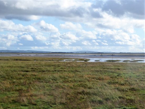
As height is gained, the West Lancashire plains are revealed. Rivington reservoir shines out below.
The summit of the pike comes into view, but we still have a fair bit of climbing to do.
On reaching the top, we realise there is a strong, cold wind blowing from the west. Sheltered spaces in the lee of the tower are all taken, so we opt for a bench in the open.
The current tower was built in 1732. There had been an older, wooden beacon on the same spot. The tower was made of stone from Liverpool, and the workers were paid in ale. The foundations of the tower are older stones; in the photo below, these stones are now visible due to erosion. The tower was constructed for John Andrews, a solicitor in Bolton and owner of the Rivington estate. It was built as a hunting lodge, featuring a square room with a fireplace and a cellar.
A passing mountain biker stops for a chat, a youngster who lives at the base of the hill. It is refreshing to find a teenager who obviously enjoys adventures in the outdoors and has the scars to prove it. Maybe because I am engrossed, I virtually forget to take any photos of the scenes around us. The coast is certainly in view. We move on when our hands begin to freeze in the cold wind. He overtakes us later.
Down the steep steps we go, against the tide of families climbing up them. This is the way most people come; we are glad of our more circuitous, less strenuous and certainly quieter route.
No, I’m not on my cycle today. Mike phoned late last night with a promise of good weather and a desire to walk somewhere fresh. So here we are on the promenade between Fleetwood and Cleveleys on a freezing but bright blue sunny morning.
Apart from dog walkers on the beach, it is quiet at Fleetwood. The Lakeland hills across the way are a little hazy, but Knott End and Morecambe power station seem within touching distance, especially with the zoom lens. There are reminders of rough sleeping in the shelters. We follow the fish whilst watching a ferry heading to Heysham with hundreds of wind turbines in the background. The wind farms have proliferated in this stretch of water.
The Coast Guard Lookout station is always worth a photo from both sides. But after that, with chatting, I don’t take many more.
Around the corner, heading south into the low sun, onto the renewed curving coastal defences is delightful promenading. There is barely a breeze, so we are cosy in our fleecy clothes, Mike more so with a heated gilet, one of his family’s Christmas presents.
More and more people are out from Cleveleys. Dogs and children on new bikes are everywhere. I pause to point out to Mike the ‘Shell’ half-submerged, the Ogre hidden in a groyne is completely submerged.
We planned to walk to Cleveleys and catch a bus back to Fleetwood. They say you can’t become lost walking the coast; just keep the water on one side. Somehow, we walk on towards Bispham, the busy main street of Cleveleys hidden from us on the lower prom. It takes some time to realise my mistake, and then we turn around to head north, to miss our bus stop again.. Only when we actually climb over to the road do we see our whereabouts, but luckily, there is a stop opposite the Vue cinema complex. We don’t have long to wait for the number 24 bus, which takes a convoluted route through bungalow suburbia to the ferry at Fleetwood, where the car was parked. The view across to the Lakes was much clearer, but my camera was stashed away by now.
I recommend a walk down the prom from Fleetwood on any decent day. Go as far as you like, and then bus back. Today the weather made our short walk memorable.
Back to earth—flooded roads defeated us on the lanes around Inskip. The NW region has been badly affected this week.
I’ve used various alliterations based on Fair and Fairsnape in past titles, so lets just keep it simple today, Fairsnape Fell. The last time JD and I were up here was nearly four years ago – time for a revisit. I was pleased with his suggested pick up time of 10 am, even more so this morning with ice on the bird bath.
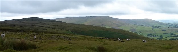
We were parked up in a little layby under Saddle End Farm at 10.30. The hoards all use the narrow lane below Fell Foot as we were to see later. It was steadily uphill for a long stretch but the sun was warm, there was no wind and the Skylarks were singing. Since my last visit here they have installed some of those green metal kissing gates. We just pottered along chatting, a few fell runners passed us on the way. This circuit used to be my training run, JD had lengthier projects.
We take the driest way along the ridge and visit the highest point of Fairnsape, 522m. despite the deep mud surrounding it.
More boot sucking areas were skirted on the way to the trig point, Paddy’s Pole and shelter. There are always a few people about up here. The last time I bivied here for the night there was a crowd of campers. Today there was room for us in the shelter, newly equipped with benches, for a light lunch.
I have to admit it’s been a difficult few days with one death after another of my closest and dearest friends. As I intimated, conversation with JD is easy, we have similar interests and political views. But what I didn’t expect as we exchanged anecdotes, as you do, how often my recently departed pal Alan, the plastic bag man, came into the conversation. Al and I went back 40 years with many adventures on the way. We can’t all live for ever.
As we headed along the ridge towards Parlick the crowds were coming up. I love this stretch with the views down into Bleasdale, across the Fylde and Morecambe Bay. A couple of gliders slid past.
Taking the easy traversing route to the west of Parlick we find that it has been very much improved in the last year, what was a badly eroded track was now a pleasant promenade and some more of those metal gates have been added. Yes and there below were the lines of parked cars if you look carefully.
We slunk off towards Wolfen Hall after negotiating an old wooden gate held up by string, time for a replacement metal one. Rather muddy paths had us back to Saddle End. It will take some time this year for the fields to dry out.
Back at the car I regretted I had no loose change for their excellent free range eggs.
A great day to be out. Good company and warm sunshine. 1300feet in six miles.
This may take some time to write up and to read. I completed the short cycle ride on a frosty January 18th. 2024.
How many times have I cycled down the seafront from Fleetwood to Blackpool? How many times have I later flown past, with the wind behind me, the several pieces of artwork without realising their significance? The answer, my friend, is blowin’ in the wind. A song still appropriate to the present troubles of our world and my wanderings.
Grab a coffee, relax, listen and read on.
I aim to put that right today. I have done a little research on the Cleveleys website. Over recent years the sea defence improvements at Rossall and Cleveleys have provided a wonderful promenade, a leisure amenity alongside the coast popular with walkers and cyclists. At the same time funding was secured by Wyre Council through Sea Change, a national fund designed to regenerate the coast through the Arts.
This gave rise to Cleveleys Mythic Coastline art work following the story of The Sea Swallow A children’s fairytale, written by Gareth Thompson and illustrated by Hannah McGee, it blends legends with local features. Each primary school child in Wyre was given a copy of the book in 2011. (I need to find out if any copies are still available – just this minute ordered ordered one from ABE Books.) The book tells of the epic story of land versus sea and uses old fables from this stretch of the Fylde coast with the sea swallows protecting it. A tale of an Ogre stirring up the sea with his giant paddle, threatening the waterfront community, only to be thwarted by the story’s heroine, Mary and her golden shell. Mary is granted the ability to journey to the seabed for an encounter with the sea-ogre, who covets the shell and threatens her village with inundation. I need to read the book to find out the hopefully favourable outcome. The story and pictures from the book have been the basis for the public artwork subsequently installed along the seafront.
***
To set the scene: I unload my bike as usual near the delightful ‘Welcome Home’ statue on the front at Fleetwood and pedal off in the freezing temperatures, my hands rapidly becoming numb. There are patches of ice along the promenade and the beach is frozen solid. The tide is farther out than I’ve seen it before and one can imagine the difficulties of navigating into the mouth of the Wyre and Fleetwood’s docks. Out to sea the Isle of Man ferry is heading to Heysham whilst a couple of freighters are leaving, with the back drop of Barrow, Black Coombe and the snowy Lakeland hills.
Once past the toppling coast watchers and round Rossall Point I’m onto the new tiered promenades of Rossall’s sea defences with concrete walls showing wavy themes in relief.
Along here are three art installations I’ve not bothered to examine before. Each one consists of three slender arching columns, grass-like, decorated with a floral theme. Ragwort, Sea Holly and Sea Spurrey and their animal dependents, Cinnabar Moth, Red Tailed Buff Bee and Common Toad respectively. I can find little information on them, but obviously, they reflect coastal species. They are sited at access points to the beach for maximum impact; perhaps they are marker posts between here and Cleveleys.
It was along here that Sea Swallows started appearing in the back wall and, at the end an impressive larger relief featuring Mary. I now realise there was another Mary ‘panel’ at the start of the wall farther back – it gives me an excuse to have another leisurely exploration.
The main installations of the Mythic Coast are from the storybook – The Shell, The Ogre, The Ogre’s Paddle and The Sea Swallow, and the nearby Shipwreck Memorial. They have all been put together by artists and designers from Broadbent Studio.
First up was Mary’s Shell, a large piece of spiralling metal in a shell shape on the Cleveley beach below the café. Looking through it at low tide is the sea; at high tide, it becomes completely submerged. The complex Conch shell was made from stainless steel in Ulverston, with a blast finish and weighs in at 17 tons. Today, the tide was out, and I could have, should have, gone down the steps to come up close, but with the bike in tow, I was content to view from the promenade.
The Ogre is easily missed alongside the boulder groyne just south of the Shell. It is in fact a boulder carved to represent the crouching giant. He was hand carved from a single fifteen ton block of limestone by the stonemason Adrian Wright and fittingly submerged for a lot of the time. Today, I was lucky, and he was plain for all to see. Again, I should have gone down onto the beach for a closer look, but as I said a good excuse to return.
Can you spot him?
The Ogre’s Paddle is on the higher promenade, unceremoniously in front of the cinemas and gym. The paddle was constructed in purple heart wood from South America, carved with decorations and text from the story by the woodcarver John Merrill.
“the Sea Ogre’s paddle drifted up to lie on the muddy sand like some strange offering”
The Sea Swallow monument is right in the middle of the promenade. A 10m tall sculpture, its shape inspired by the feel of a book coming to life and the swallows flying out of it.. The swallows are the town’s protectors, and I now realise are representative of Sea Terns. Just look at that blue sky.
“This feature acts as a visual beacon to draw people from the town centre to the seafront” . The granite was supplied by Hardscape, and the aluminium structure fabricated and installed by Chris Brammall Ltd. of Cumbria.
‘For at night they stand together on the sea wall, as if protecting the town with their great white wings.’
Illustrations from the book have been carved and blasted into the granite base of the sculpture. “maybe somewhere along the coast, the shell waits for someone to find it again”
You may have noticed everything is curvy (wavy) on Cleveleys promenade, often practically to soften the force of the waves but more of an ongoing architectural statement. I think it works quite well.
The last piece, the Shipwreck Memorial, stands proudly on the Cleveleys Promenade. A huge piece of iron, 15mm thick, laser cut with the names of lost vessels. It stands 4.5m tall against the sky, supported by two huge solid pieces of timber. The metalwork is slowly rusting, as would have the sunken ships.
It acts as a memorial to all known ships lost along the Fylde since 1643. It is positioned on the promenade at Cleveleys, adjacent to the site of the most recently lost ship – The Riverdance, which ran aground in 2008 and became a tourist attraction as it slowly lost its cargo and was subsequently dismantled. In the same area the wooden ribs of The Abana, sunk in 1894, still show up at low tide. Apparently, they can be seen through the disc in the memorial, I should have looked more carefully.
On the wooden supports are a couple of panels listing all the ships with more information about their wrecking. A sobering list, a huge graveyard of over 200, The first listed as Unidentified, wrecked near Fleetwood in 1643 having run aground after being set on fire by Loyalists in the Civil War. In more modern times, the Trawler industry suffered disproportionately. A full list of wrecks has been transcribed onto a page on the Cleveleys website.
A final installation – Coloured Sea Swallows, cast in resin, was planned to sit along the seawall on the Cleveleys promenade. They have been temporarily removed following the unfortunate theft of several of them, and are awaiting re-siting.
Historical picture.
The Shipwreck Memorial stands on the border between Wyre (Cleveleys) and Blackpool. I’ve gone as far as I want today; it’s time to head back.
But first I stop to watch some activity on the beach. They are building more stone groynes to prevent potentially dangerous deep-side channels from developing across the beach. Blocks of stone, Granite from Shap and Limestone from Carnforth, have been ‘dumped’ on the beach. Concrete ramps to allow access along the beach have been built, and they are now starting to carefully place the boulders at right angles to the prom, forming the groynes. Each block weighs between 3 and 8 tons; anything lighter would get washed away in storms.
Needless to say, I haven’t seen any Sea Swallows but a cheeky Starling joined me for some lunch.
Thanks for sticking with me. Maybe listen to Bob again.
A very popular climb from Scorton on the edge of the Bowland Fells. I never get bored of this little fell. How many times have I been up it? See here, there and everywhere.
But where has the name come from? Who was Nicky? No amount of internet searching gives any clue, locals don’t seem to have any idea either. Any suggestions?
A nook is “a small quiet place or corner that is sheltered or hidden from other people” That’s not the case up here any more, there is nearly always a steady stream of people walking up the steep steps from Wyresdale. They don’t know any better as there are far pleasanter ways to reach the modest summit from more roundabout ways. JD and I followed one of these to the top today.
The side road I normally park on was closed due to works, but there was plenty of space on the main road into Scorton. The ‘works’ didn’t progress much whilst we were out for the day. How much local authority funds are wasted for the lack of adequate overseeing? Too many questions today.
We left the lane at the inviting Wyre Way signs. I blamed the low winter sun for our almost blind wanderings over only just frozen fields. There was certainly one point where a new fence across the line of the right of way was lacking a stile, (GPS defines these spots accurately, note to Lancs Highways Authority sent) The onward haphazard wanderings however were all my fault. We found ourselves, don’t ask me how, in a bare harvested maize field which had the appearance of a pheasant shoot. I was concerned it could become a peasant shoot if we didn’t find a way out. The road was just across the other side of the hedge but we couldn’t find a gate. I suggested we swallowed our pride and retreat back to the right of way. But no, JD is sometimes more persistent, obstinate and intrepid than even I. He is to be seen escaping from Colditz.
Regrouped we soon left the lane onto the bridleway up into the woods of Grize Dale. We were not the only ones, a large shooting party were just setting off into undergrowth to kill a few pheasants. (Is this activity exclusively male I wonder?) Fortunately we were well on our way before the shots ran out, would have been a shame to spoil the day. The rhododendrons are taking over on this side of the fell.
The reservoir seemed fuller than usual, but that was no surprise after all the rain in December. Today was all blue sky, the feel like temperature in the brisk easterly was well below zero. More to come this next week, no more rain in the foreseeable future. But as we live in the northwest we will wait and see.
I took JD on the long way round to find the easier graded ascent of Nicky, as you can see from my map. That surveying pillar guided us upwards but it was a false siren, the true summit was still some way up the hill. The shining white trig point was soon reached along with many others coming the other way, all well wrapped up against the wind, and their dogs. Only 215m but a view all around. The outlying Bowland Fells behind us, the Fylde below us and the motorway heading up to Lancaster and the more distant Lakes. It is said you can see from the Great Orme to The Isle of Man.
The onward path, previously eroded and muddy, has been upgraded with chippings and soon we are back in the valley. Is Applestore café closed on Tuesdays? Maybe we missed a chance there. I was pleased to find the public footpath around Snow Hill barn is still passable and possibly improved. It took us into woods above a very steep drop into the brook. Escape was possible over a wooden footbridge. JD noticed the original stone slab bridge below, it was still intact, if a little narrow. Obviously Health and Safety have been in play.
The parking was busier now in early afternoon opposite that iconic, seen from the M6, church steeple. What a lovely little round and we were back for tea.
Sat alone on the isolated true summit of Fairsnape, deep in Bowland, I’m poking at one of my sandwiches, egg and tomato, made a month ago. They went into the freezer when hot weather and circumstances cancelled an outing at the last minute only for them to re-emerge this morning. there is a distinct unappetising taste. Should you freeze hard-boiled eggs? I’ve just traversed some of the loneliest hills up here and am in need of some sustenance. The morning has been misty on the fells, however with a welcome cooling breeze. Distant views are restricted from my lofty perch, most of you will never have been here. Only a few curlew and grouse share my space. I poke again at the sandwich and decide to toss it into the heather for probably the seagulls, who now also patrol these heights, to scavenge.
As I say the day started off murky and cool with low cloud, quite the opposite of the mini heat wave we have been enduring. Ideal for a tramp across these Bowland hills. For a start don’t take Mark’s advice to leave your car in the Delph Lane car park, it’s none too safe and leaves you with quite an uphill walk before you start. There are suitable lay-byes nearer Stang Yule. Walk number 2 in the Cicerone’s Walking in Lancashire book.
The way starts at a gate leading onto open access land. Welcome. On closer examination a notice says ‘No open access – temporarily closed at the land manager’s discretion’ Not a good start at all. But wait, the date is 2021. This sign has not been removed or updated for two years. So much for the land manager.
I try not to read too much into this as I stride boldly onto the access land. Nobody will see me in the mist. I’m enjoying the heather under foot, there is a path of sorts but not many come this way, put off by that notice possibly. Slowly I gain height and pull away from the plantation onto the open fell side, A track takes me across the slopes of Hazelslack Fell, a rarely visited spot. The last time I was up here was with Sir Hugh and JD on our straight line adventure between our homes. It’s as remote as I remember.
The views back to the Fylde are supposed to be good.
Approaching Hazelhurst Fell.
Looking back with the track skirting below the summit of Hazelhurst.
I don’t bother with the 429 m trig point this time as I’m probably going higher shortly. The track dips down and climbs the contours gradually onto Winny Bank. The raison d’être for this track becomes obvious with the appearance of shooting butts. Not only the butts but also the small mammal traps, thankfully decommissioned. The highlight of my week, if not the month, was witnessing a family of Stoats crossing a road on Longridge Fell. Distinctive with their black tipped bushy tails. Who would want to trap and kill these beautiful animals??
Along the way is a stark memorial to airmen lost on these hills in WWII, I have a book somewhere listing all these crashes and giving their accurate sitings.
The track starts to descend, and I have to be alert to pick up the ongoing path to Fairsnape otherwise I would be floundering, I know not where. The path begins somewhat unlikely with a few steps leading off a turning place. The stone flags don’t go far and one is left following intermittent white posts through the morass of peat. You will be glad you came here in dry weather, preferably a draught, also not a good place to be in thick mist. Stick with it, and you will arrive at a fence corner euphemistically named Webster’s Meadow. (if you miss it you would be in ‘Dickey’s Meadow’) This is also known as Fiensdale Head, the way through from Langden to Bleasdale. A partially flagged path shows the way. it’s a long time since I’ve been down Fiendsdale, a good spot to see ring ousels. No idea who Webster was or Dicky for that matter.
Turning spot.
The way down to Fiendsdale.
United Utilities have an information board explaining the work being carried out to try and reverse some of the peat erosion. When I was last up here they were helicoptering bags of stones in to be incorporated into ‘dams’, stopping further erosion from run off and re-wet the surrounding peat. Evidence of that work is all around with stone and fibrous matting in the peat cloughs. One does wonder how much we can do to repair the damage which must be on a vast scale in Bowland alone. Are you still able to buy peat based compost – I hope not?
A few more flags are encountered, showing a way down to Bleasdale and ahead to Fairsnape. Then you are on your own again with the fence for company. The book talks of ‘hard going’ in the peat hags – ‘hopping over to the other side of the fence may help’ Today that is not necessary as it is as dry as it is going to get, but there are still boggy morasses you wouldn’t want to fall into, perhaps the re-wetting is working. Knees are allowed for climbing out of the deepest hags.
Anyhow, I’m soon sat at the 520 m summit contemplating my lunch. There is another informative board up here telling the same story. Some of the funding came from the EU, pre Brexit. How much will our own DEFRA run by Thérèse Coffey put into environmental schemes?
It’s a dry run over to the other summit of Fairsnape, the one with the shelters and trig point. I’ve not seen anybody all day so far and can’t believe I’m the sole person at this popular top. Only when I get closer to the shelter do two heads pop up – a young couple having some private time to themselves.
The mist has lifted a little allowing the gliders from the club down below to take to the thermals, spookily and silently sliding past out of the thin cloud.
The way off, by a cairn, is down some zigzags into Bleasdale. I have always assumed these to be part of a sledging route for bringing cut peat off the fell. Beautifully constructed and a joy to walk whichever direction, up or down. Few people used them as most are linking Fairsnape with Parlick along the ridge. But Mark knows this area well, covering Bowland in detail, the secret is out.
What a contrast from the northern side of the fells – endless peat and heather as far as the eye can see and down here in Bleasdale with the green pastures stretching to Beacon Fell. The guide book takes you on tracks that would give access to Bleasdale Circle, but I’ve been there many times and at the moment it is a bit of a mess following storm damage to the trees, so I take a slightly different route through Bleasdale, past remote farms, past the old reformatory school buildings and past Bleasdale Tower. North Lancashire Reformatory for Boys, Bleasdale, near Garstang, Lancashire (childrenshomes.org.uk)
That little lay-by.
The little blue car was waiting for me in that lay by, as a Duke Of Edinburgh group were going through, staggering in the heat under massive rucksacks. I wonder who had the better day?
A calm sunny day out of the blue. A day that shouldn’t be wasted. Cycling will be better for me than all that weight-bearing walking on my dodgy knee. Yes it has officially become dodgy. Most people parked up on the front at Fleetwood are content to sit in their cars with the heater on, gazing out across the Wyre Estuary to Morecambe Bay. Somehow the statue of the waiting family took on a more poignant significance as the nation waits for news of Nicola Bulley who has vanished higher up the Wyre at St. Michaels.
In a sombre mood I pedal off along the seafront, Rossall, Cleveleys, Bispham, North Shore, The Golden Mile, the Pleasure Beach and South Shore. All familiar landmarks of the Fylde Coast at Blackpool. There are few people about, despite the sun it is still chilly. Mainly dog walkers. I eat my sandwich at Squires Gate, I’ve come far enough and turn around to do it all again in reverse. This is a favourite ride of mine, flat all the way with lots of interest and all that good ozone and vitamin D producing light.
The peaceful winter promenade.
Mary’s Shell in the tide. The Ogre was under water – more of them and the Mythic Coast another time.
The tower silently watching.
A Ringed Plover? posing. Not a grouse in sight.
I stop briefly to chat to a fisherman casting into the sea from the shingle beach, it’s high tide. Dabs and cod could be on the menu tonight but the only catches I witness are seaweed. A patient sport angling.
What’s for supper?
That was it really. All quiet on the western front.
I was in Lytham a couple of days ago seeking out the memorials relating to the Mexico ship disaster of 1886 which led to the deaths of 27 lifeboatmen. The worst loss of life in the history of the RNLI. Chatting to one of the locals on the Lytham Promenade, he enlarged on the Cliftons of Lytham Hall, an interesting family by all accounts, and the influences they had had on the town over the centuries. He mentioned the mysterious Witch Wood.
Witch Wood is what’s left of The Big Wood, a 5,000 acre site, once part of Lytham Hall Home Park. The Cliftons ran into financial trouble and sold off the estate to Guardian Royal Exchange in 1963. Somewhere along the line the local council gifted the remaining derelict Witch wood to Lytham St. Annes Civic Society who proceeded to create a narrow strip of woodland, a green corridor in the heart of the town. Undergrowth was cleared and new native trees planted. A plaque says the woodland was officially opened by Prince Phillip in 1974.
The Western Exit, notice the cobble wall of Lytham Hall estate.
My visit, with cycle in tow, was going to be brief. The approach, after visiting St. Cuthbert’s Church, was along an old private driveway, now open to pedestrians, over the railway into the old Clifton Estate.
I’d been told of the Witch’s Grave inside these woods. Spoiling the story, not a female scary Witch but a horse belonging to John Talbot Clifton, the squire of Lytham Hall. The horse, Witch, had an accident in 1888 within the woods and a gravestone apparently marks its resting place.
Once in the woodland strip do I go left or right to find the grave? I go left, westwards, along a well-used path, no cycling allowed says the sign. Fair enough. The narrow wood is bounded on the south by the railway and to the north by a largely hidden housing estate. It should be easy to spot the grave especially at this time of year with little undergrowth. Of course, I don’t really know what I’m looking for. After walking a few hundred yards I have not found the gravestone. I turn around and head back.
A local couple are walking towards me – “excuse me, do you by any chance know where the Witch’s grave is?” ” Yes you must have passed it back there – it’s on the right in the trees” They offer to show me where, and I retrace my steps once more. It is evident they are very proud of their wood and extol the virtues of the Lytham Civic Society and all the good work the volunteers do. They are not too keen on irresponsible dog owners or cyclists. I wheel my bike quietly beside me. Next thing my guides and I are at the far western end of the wood where it joins the road without encountering the grave. They apologise, explaining they were distracted by our conversation. I apologise for troubling them and turn tail to try again.
Along the way I gather up more ‘knowledgable’ locals in my quest. “I think it is in the other half of the wood” is a popular opinion. So over the driveway and into the eastern half of the wood, we spread out scouring the undergrowth. They begin to lose interest but say they will shout if they find it as they scatter off onto side paths. I retreat to the western half as advised by the next group of locals, one who had walked these paths as a child believing in the Witch and fairies in the trees. For a while I follow them but begin to doubt their reliability and hang back, bicycle still in tow. That’s about a dozen locals I’ve consulted so far, it can’t be so difficult, surely. Back to the central driveway.
At last a pleasant lady with spaniel, must be local. I repeat my request and all of a sudden positivity arrives. She marches me without any fuss to the spot maybe a hundred yards away which I must have passed half a dozen times. I thank her profusely, she looks at me wondering whether I will be able to find my way out.
To be honest the gravestone is small and not that obvious in the trees. The stone is inscribed – The Witch. Died Jan 5th 1888. Satisfied, I can continue on my way now, not daring to mount my bike till well out of the wood. I cannot give you a grid reference for the stone – best of luck if you go in search. Try asking a local.
“The sea ran mountains high, and the breaking water was fearful”. Coxswain William Clarkson Lytham, Lytham Lifeboat Charles Biggs.
***
The tracks and lanes are still icy up here in Longridge. I want to get out on my bike, so opt for the hopefully snow free and safer Fylde Coast, there have been more than enough ‘accidents’ in my posts of late.
Has everybody had the same idea? The roadside car parks are all full and a mass of mainly dog walkers throng the promenade. And bracing is the word that comes to mind. The bracing was in the arctic breeze from the south, and it was in a southerly direction that I started. It will be easier on the return is once more my reasoning.
I’m always focused when pursuing a mission, and I’m on a mission today. I’ve been reading about the wreck of the sailing ship Mexico on the sands of the Ribble Estuary on the 9th December 1886. Worth a read here.
Basically the Mexico out of Liverpool became stranded on Ainsdale sands in a violent storm. Lifeboats from Southport, Lytham and St. Annes were launched. Those from Southport, Eliza Fernley, and St. Annes, Laura Janet. were both wrecked in the storm with the loss of 27 local men, (2 had survived from the Southport boat) . The Lytham boat, Charles Biggs, however rescued the 12 crew of the Mexico and rowed them to safety. An heroic effort but the single biggest loss of life in the whole history of the RNLI.
There are a series of related monuments and memorials scattered around the Ribble Estuary towns, Lytham, St. Annes and Southport. I’m only concerned with the first two today. Despite all my cycling exploits on this stretch of coast I have previously been unaware of this important history. How often must we go about with our eyes closed?
***
First up is probably the most prominent, the St Annes lifeboat monument, depicting a lifeboatman, on the South Promenade, It is almost hidden behind walls in the ornamental St. Annes Promenade Park, next to the public conveniences, no wonder I’ve passed it by in the past. A William Birnie Rhind designed it in 1887. A colossal statue carved in sandstone with the names of the 13 lost from the St. Annes lifeboat, Laura Janet, The attached notice encapsulates the story.
Up a main road, and I was at St. Annes Parish Church. Commissioned by Lady Clifton in the early 1870s, one of Paley and Austin’s, and named in memory of her aunt who was called Anne. (the Clifton family from Lytham Hall were prominent in the area for centuries) It was built as a chapel of ease to the then parish church of St Cuthbert in Lytham. Here are buried five from the Laura Janet boat. It is heartening that the Laura Janet Memorial has had a recent refurbishment funded by the local Civic Society. I found it in a forest of elaborate memorials, a sandstone Celtic Cross inscribed with the names of the men. The Church, Lychgate and Memorial are all grade II listed. Notice the pebble detail in the walls, a common architectural feature in St. Annes and Lytham.
Winding back through side streets I find the original St. Annes Lifeboat House, on East Bank Road, now a funeral parlour but with a blue plaque to commemorate the disaster, and an unusual weather vane. It seems odd that this boathouse was so far inland whilst the new one is on the shore.
After a pleasant cycle down the promenade I was at the site of the original Lytham Lifeboat House on the edge of the estuary. In the summer months it is open as a museum to the lifeboatmen. It was from here that on that fateful day in 1886 that the Lytham boat, Charles Biggs, rescued the 12 crew members of the Mexico.
On the marsh shore are a couple of anchors caught up in a trawl net by a fishing boat in the 1980s. The larger one is of the type lost from the Mexico. The other dates back to the late C18th used by warships from the time of Admiral Nelson.
Time to find the memorial in the graveyard of St. Cuthbert’s Church a few blocks inland. From the promenade I made my way through Lowther Park (more of that another time). The church dating from 1835 stands alongside a busy road, but the graveyard is peace and quiet. The Laura JanetMemorial was easy to spot, being the tallest around. A Gothic pinnacled tabernacle. Plaques told of the crew and where they are buried.
Whilst I was hereabouts I discovered the Witch Wood – but again I will leave that for another time. All that remained was to cycle back up the promenade, thankfully with the wind behind me, to where I had parked on North Promenade.
The RNLI is a charity saving lives at sea and deserving our support. How much of the infrastructure of Britain now relies on dedicated volunteers and funding raised by the public?
***
THE CREW OF THE ST. ANNES LIFEBOAT LAURA JANET.
William Johnson, 35 (Coxswain)
Charles Tims, 43 (2nd Coxswain)
Oliver Hodson, 39 (Bowman)
James Bonney, 21
Nicholas Parkinson, 22
Richard Fisher, 45
James Johnson, 45
John P Wignall 22
Reuben Tims, 30
Thomas Parkinson 28,
Thomas Bonney, 35
James Dobson, 23
James Harrison, 19
THE CREW OF THE SOUTHPORT LIFEBOAT ELIZA FERNLEY.
Charles Hodge (Coxswain)
Ralph Peters (2nd Coxswain)
Benjamin Peters
Peter Wright
Thomas Spencer
Thomas Rigby
Timothy Rigby
Harry Rigby
Thomas Jackson
Peter Jackson
John Ball
Henry Hodge
John Robinson
Richard Robinson
The Southport crew have their own memorial and burials in Southport across those treacherous sands. Next time I visit there I will be on the lookout.
***
1. St. Annes Lifeboat Monument. 2. Laura Janet Memorial, St. Annes Church. 3. Old St. Annes Lifeboat House. 4. Old Lytham Lifeboat House. 5. Laura Janet Memorial, St. Cuthbert’s Church. W. Witch Wood.
I wouldn’t normally dream of coming to Blackpool on a Bank Holiday Monday. Perhaps Sir Hugh’s recent mouth watering post on ‘fish and chips’ has subliminally decided for me.
There is very little traffic on the motorway, and I am able to park easily at Lytham which means I can start my ride in the opposite direction compared to my choosing the more usual plentiful parking at Fleetwood. I don’t actually reach Fleetwood today, content to turn around at Cleveleys to give a round trip of 30 miles.
There is always a breeze on the coast, and today it was north-westerly, meaning I cycled into it for the first part. No matter how gentle the wind is if you are facing it on a bike you are slowed down. Maybe I should shave my legs and beard to reduce wind resistance. The advantage was on the return leg when I sailed along at a much faster pace.
I didn’t expect really to feast on fish and chips today as I knew the cafés would be closed along with everything else. The Golden Mile – no blaring pop music, no loud bingo calls, no flashing lights to entice you into some dive or other, no ‘Kiss me quick’ hats. No ice cream and definitely no fish and chips. Not a queue in sight. The promenade was virtually empty of people, making cycling a lot less hazardous. Although it is amazing how much space a couple with dogs on long leads can occupy on a wide shared way. I remember a phrase my parents used if they came across an empty or quiet situation where bustle was normally expected. “Someone must have died”
Of course this Bank Holiday wasn’t on my calendar in the first place. Someone must have died.
As I returned to Lytham more people were promenading and visiting the beach (the tide has been out all day) Families enjoying the late summer sunshine. Even the occasional ice cream appeared. You can’t watch TV all day.
[I stop to pick some Evening Primrose (Oenothera biennis) stems, not to eat though all parts of the plant are edible, but to collect some seeds. I would dearly love to have this bright yellow late flowering plant popping up in my borders as others die away. Once or more likely if, I have germinated some they should self perpetuate. Easy gardening.]
Tomorrow all will be back to normal, and we can start worrying about the state of our Great Britain under a new King and Parliament.
I’ve just cycled a 16mile stretch of the Fylde coast, Fleetwood to St. Annes and then back again. As I’m putting my bike back in the car I spot a heavily laden touring cyclist.
“Have you come far?” I ask.
“Yes I’m cycling around the coast of Britain”
“Gosh – For charity?” I ask seeing the Multiple Sclerosis logos on her T-shirt.
It turns out that Lis has been diagnosed with MS in 2013 but is determined to complete this 6000mile challenge to raise funds for the MS Trust as well as benefiting her own health. She is amazing, full of enthusiasm after three and a half months pedalling. We swap a few stories, I donate to her charity, and she cycles on towards Blackpool and then Preston. The balloons on her bike celebrating her 50th birthday today. I’m well and truly humbled with my small stretch of coast. https://www.justgiving.com/fundraising/LisvanLynden
My day started when my clandestine climbing partner phoned to say he might have caught Covid on his recent trip to Montenegro and didn’t think he should go climbing. Neither did I.
The bike was already in the back of the car, and soon I was on the M55 heading to the Fylde. The traffic was heavy, I wondered about the possible bank holiday crowds on the promenade in Blackpool. However, parking at Fleetwood sea front is always easy. I pedalled down the coast, had a snack at St. Annes and pedalled back against the wind. The only busy spots were between the tower and the pleasure beach. ‘Kiss me quick’ hats de rigueur.
Empty prom north of Blackpool.
Crowds thinning out on St. Annes beach.
Heading back to Fleetwood.
‘Steampacket’ to Ireland passing Black Combe and Barrow.
Job done – well not quite. In the week I had listened on Radio Lancashire about the unveiling of a memorial to a lost trawler boat, the Goth.
GOTH.
The trawler, the Goth, failed to return in December 1948; 21 men were lost in a fierce storm off Iceland. Then, 50 years later, the funnel of this vessel was trawled up in the net of an Icelandic boat, Helga. The Goth’s last resting place is now known. The funnel was eventually brought back to Fleetwood – to become a lasting memorial. It survives as a reminder of the Fleetwood fishing community and a way of life of courage, comradeship, generosity and good humour.
Fleetwood at one time was a major port, the third largest in Britain, for the trawler industry, no longer alas. On the seafront where I park are several reminders of the hardships and losses of these seagoing boats and crews.
Welcome Home. Anita Lafford
Past this place, the fishermen of Fleetwood have sailed for generations while their families watched from the shore. Their courage and comradeship under hardship is a living legend. This memorial, depicting equipment from a trawler, was placed here in recognition of the great contribution which the men and women of the fishing community have made to the life of Fleetwood.
The plaque lists 39 trawlers lost in 50 years with an awful loss of lives, which can be seen if you click and enlarge this photo —
But there was no sign of Goth’s funnel along the seafront with the other tributes; I had to ask a local where the memorial funnel is located. He somewhat ashamedly tells me it is on an inland roundabout next to Asda! I drive there and park up. A grotty path around the side of the supermarket takes me to the edge of the busy roundabout. And yes here is the memorial funnel squeezed ingloriously into the roadside.
I can only assume that the cooperative cash of Asda has paid for this location. But how on earth has it been approved – nobody can see it. I challenge Wyre Council to come up with a decent reason. How much better if it had been located on the seafront or at Mount Park for all to appreciate. Lunacy.
I arranged a walk with my son today whist he is off work and I took him on a repeat of one of his early childhood walks of which he had no recollection – the classic Nicky Nook circuit from Scorton.
This involves parking near the local parish church, St. Peter’s, famous for its steeple, a landmark visible from the M6 going north. The time was 3.00.
We didn’t mess about on field paths low down, just walked up the quiet lanes until there was access into GrIze Dale. I always enjoy the stroll up this deep wooded valley, today there was only a trickle of water in the beck. The Grizedale Reservoir was the lowest I have ever seen it.
Walking up the gentle side of the hill we started to meet more people, but generally the place was deserted.
That’s not the top.
We stopped at the freshly painted trig point to take in the views over the Bowland hills, the motorway snaking north, Morecambe Bay and the Fylde. That is why most people come up here.
This is.
Down the steep side and into Scorton where we take the lane to the church whose clock now says 5.30.
An innovative sign.
Time for a beer and a Chinese meal back in Garstang. He still didn’t remember the childhood walk but enjoyed the excursion, it’s good to share.
I was confused by the rash of Bank Holidays and Jubilee Festivities and found myself in the midst of Blackpool’s celebrational party, and they know how to party here. The crowds were too thick to cycle through safely, I was returning from Lytham to Fleetwood on the promenade. This was my first time out on the bike since my collision here which resulted in torn knee ligaments. I was being extra careful.
I had accomplished my mission to visit the Mussel Tank which I’ve passed so many times without realising it was there, thanks to Shazza for highlighting it. There is some purpose to blogging after all. The tanks, built in 1934, were used for cleaning the mussels harvested from the muddy Ribble Estuary. By the mid 1950s the beds closed down, mainly because of changes in the Ribble channel affecting restocking. There were three tanks. A cleansing tank now the RNLI, a chlorination tank now the Ribble Cruising Club and the storage tank now the Mussel Tank which has been given a face lift as an open space for public enjoyment. There are interpretation plaques about the mussel trade, an art wall displaying ceramic tiles portraying local features produced by students at Lytham Sixth Form College. There’s also a large-scale mussel sculpture by a Martyn Bednarczuk which I thought resembled a smiling dolphin rather than a mussel.
One of the original tanks. Lytham St Annes Civic Society
I was glad to see that they had restored the sails on the iconic windmill.
Nearby was an installation by Tom Dagnall reflecting on the diversity of the SSSI Ribble Estuary.
It was time for an excellent coffee break in St. Annes.
There seemed to be an awful lot of people on the prom in the vicinity of the tower. I just assumed Jubilee celebrations but as I cycled on there were more and more camera clutching folk by the tram line.
I stopped to enquire and was informed of a parade of trams from the past. Nothing seemed to be happening, so I cycled on keeping to the higher way alongside the tramline. Eventually the parade arrived. A motley collection of Blackpool trams and an exquisite turn of the century Bolton tram. There was a lot of flag waving from the passengers, they must have thought me a misery. The photos may mean something to someone.
I made it back in one piece, quite pleased with the 30 odd miles I’d cycled.
I’m back again, this time on my cycle. There is a place I want to visit in Lytham, the historic mussel tanks, which were highlighted by shazza in a recent post. I knew nothing of them before. To make a day of it, I decided to park at Fleetwood and cycle down to Lytham and back along the promenades. Parking is easy in Fleetwood and the wind was coming from the south, so I would have it behind me on the return leg. Things didn’t go to plan.
I’ve not been on my bike for weeks due to problems too personal to mention.
I pedalled out of Fleetwood and immediately found the headwind stronger than I was expecting. Never mind, head down and push harder.
The tide was going out and in these northern reaches I virtually had the promenade to myself. I’ve ridden this stretch several times, so I didn’t stop for photography, I only had my phone. (I have included a couple of the concrete murals at Cleveleys) One has to keep one’s wits about one as there are several layers of promenade and the drop-offs are not always obvious. Dog walkers are the major hazard with those long leads, but I share the space happily and patiently. Blackpool Tower came into view halfway to Lytham. The prom became busier with out-of-season visitors, although Blackpool looks even seedier in the winter months, when many businesses are boarded up. The fun starts at Easter.
Onwards past the Golden Mile and the Pleasure Beach’s empty rides. I cycled around the end of the tram terminus and found the way was discontinued. I was looking for a way through when I came into conversation with a lady resting on a bench. She warned me that the route into St. Annes was under major roadworks and the cycle way was closed. I could have found a way along the road, but she insisted it was unpleasant with heavy traffic. I didn’t need much persuading to turn around and have the wind behind me for a while.
What a difference, instead of struggling along trying to keep up 10mph, I was flying along effortlessly at 15+ mph. Maybe that was my downfall. As I approached South Pier, a large workers’ van was parked across the prom and as I swerved around it, I met at speed another cyclist swerving towards me. Next thing, I was over the handlebars, feeling shaken and a little foolish. His front wheel took the brunt of the collision and looked worse for wear. Introductions over, we sorted his bike, a ‘racing machine’ which was no match for my ‘mountain bike’. All was well as we chatted about common causes, and then we pedalled off in opposite directions. Not the meeting I wanted.
I was soon back into Fleetwood and was glad to stop off at Dave’s Café for toasted teacake and coffee. Then I was loading my bike back into the car for the return journey home. Mission unaccomplished, but a welcome diversion in the sunshine from all our present problems.
Sunday and I take the easy way out again as lunchtime comes around. I pick another walk from Mark Sutcliffe’s Cicerone Lancashire guide. Not wishing to drive far, I find a low level circuit from Great Eccleston in the Fylde. It turns out to be one of the flattest routes in the county, with only a few feet of ascent on the return leg. It was good to get this rural walk out of the way before the cattle are put out into the fields.
My plan when I revisited this book was to maybe do one walk a week as an incentive to get me walking farther, but somehow I’m up to number four in just over a week. So far I’m impressed with Mark’s style, he has chosen well, and his directions have been spot on – suitable for the casual walker. Today’s walk was complicated in places, and yet I didn’t put a foot wrong.
I find a place to park in the main street only to see it is an electric charging point. Having moved the car I walk out of the village past the old pinfold, on across the main road and down a well-used, dog walkers mostly, path to the river Wyre. Here is a fairly unique private toll bridge next to the Cartford Inn. The ‘cart – ford’ prior to the original C18th bridge. In the grounds of the inn are modern staycation ‘pods’. I recognise these from a walk I found for myself last winter, or was it the one before – the pandemic seems to have confused my recall.
Easy walking along the riverbank to a footbridge where I crossed to the road near the extensive and impressive, possibly haunted, grounds of White Hall. I often wonder who owns these multi-million pound properties – Russian oligarchs?
Using farm tracks, I joined The Wyre Way, linking farms in this flat rural landscape. This is the way I should have come on my disastrous attempt on this section when I almost drowned and then lost my map, leaving me with no alternative but to follow the road.
The guidebook said, “head for the grain silo” and it was correct, the silo stood out across the field, one of the tallest I have seen. In the distance were the Bleasdale fells, everywhere else was flat, a strange landscape for one accustomed to the hills.
Turnover Hall was next. There were duck ponds with piles of grain to fatten the birds before they are shot. The Hall is surrounded by hundreds of caravans, whether for sale or in storage I couldn’t make out. Oh, and just for good measure, the obligatory junk waiting to be recycled.
I rejoin the Wyre embankment and walk into St. Michael’s, arriving at the road bridge near the chocolate box cottages and the Medieval church across the way.
You know I like an interesting church when I see one, this one is Grade I listed. It is thought a church existed here, near a safe river crossing, from 640AD. The Domesday book mentions a church on the same site. The present structure dates from the C15th. When you enter the church, the most obvious and unusual sound is the loud ticking of a clock, the giant pendulum hanging on one side of the tower. There are two naves and a northern Chapel. This Butler chapel has older Medieval stained-glass fragments, seemingly randomly incorporated into the windows. In the same window is a C16th Flemish sheep shearing scene. In the west wall is a striking modern window depicting the parable of the ‘sower’. Outside is a ‘Norman’ door and an ancient mounting stone. In the graveyard are three unusually shaped graves, these are the ‘Soldiers Stones’ dating from 1643 when a Spanish ship was wrecked on the Wyre estuary and thought to be for Spanish sailors.
Time to move on, and I take a lane heading towards a large modern house. Whoever built it had visions of grandeur now biting the dust, the house being an empty shell.
The rest of the afternoon I follow drainage dykes across the landscape, eventually to rejoin the Wyre for the last time before re-entering Great Eccleston. The two bulls face each other across the high-street, with a period Austin7 on show.
That’s quite a lot for a lazy Sunday walk in this quiet corner of west Lancashire.
Somewhere I have a book detailing interesting graves in Lancashire, Who Lies Beneath? I can’t find it at the moment. But I remember visiting Woodplumpton a couple of years ago when I was taking my late friend with advanced Alzheimer Disease for a ride out and a lunch in the splendid Wheatsheaf Inn. After lunch of fish and chips, her favourite, we crossed the road to have a look at St. Anne’s Church. I always wanted to return to search for a curiosity in the graveyard. On a ride some weeks ago, the road to Woodplumpton was closed due to the substantial work on Preston’s Western Relief road. I intended to make amends today and cycle in from a different direction.
I’d come through Inglewhite, Bilsborrow and Cuddy Hill. After the motorway and A6 it is all fairly flat with a maze of lanes, many seemingly going nowhere. A sort of no man’s land between the motorway and the Fylde. I crossed the Lancaster Canal a couple of times and passed the Plough At Eaves, a pub we used to visit when working in Preston, but that was years ago. The pub is one of the oldest in Lancashire, dating back to 1625. In former times it was variously known as the Plough at Cuddy Hill, the Cuddy Pub and more unusually the Cheadle Plough Inn. It has recently been refurbished, so I wonder what they have done to the cosy inside.
Once in the straggling village of Woodplumpton, I ignored The Wheatsheaf and headed straight to the Medieval church on the other side of the road. Outside the church’s Lychgate were the ancient stocks and mounting block. I found the squat sandstone church open, it was a Sunday, and was impressed with the stained-glass. Those well known Lancaster architects Austin and Paley were responsible for renovations at the beginning of the C20th.
But my main search was outside in the churchyard for the burial place of an alleged witch, a local 17th-century woman named Meg Shelton, also known as the Singleton Witch or the Fylde Hag.
According to legend, she was feared by the local community and tales grew up of her changing shape and form to steal food and create mischief. She died in 1705, crushed between a barrel and a wall. Apparently it was thought that she miraculously escaped from two graves and was then buried head first in a narrow slot, a boulder placed on top of her to prevent further escape. The disturbance of the first two graves could have been caused by vandalism towards her.
I soon found the boulder in the rows of conventional headstones. It was about a metre across and looked a hefty barrier even for a witch. A little brass plaque identified it and there were remains of some flowers placed alongside. I found it strange that she had been buried in consecrated ground, though there was a rumour that she was a mistress to the local lord, who might have arranged her burial.
She died a century after the infamous Pendle Witches, but her kind were still feared by the community. Did she practice the dark arts, using herbal remedies and so-called spells? Thus earning herself a reputation and being blamed for calamities in the general run of life by the more suspicious locals. Had she been mentally ill, frightening others and becoming marginalised? Or was she just the area’s criminal? It would be hoped that people’s illnesses or differences would not be victimised in the same manner four centuries later. Perhaps that bunch of flowers shows some understanding.
Whatever the truth in Woodplumpton, there was certainly a bewitching sunset back in Longridge.
I didn’t have time to cross from Fleetwood on the ferry to Knott End last week, so today I’m cycling there from Garstang on hopefully quiet lanes. I was last at Knott End in March 2019 when I walked along the shore to Pilling, that was just before lockdown, and as I remarked in the comments “I didn’t hug anybody”. There has been a lot of water under the bridges since then, but Covid still worries me with our high infectivity rates and deaths.
The lanes I choose were indeed very quiet, with only the occasional agricultural vehicle. I was supposed to be on a National Cycle route 5 or 7, but there was never a sign. Pedalling along in my own world until I reached Pilling, a spaced out village with no discernable centre. I pondered at the naming of the Elletson Arms and Smokehouse. I wasn’t sure if it was still trading, the Golden Ball around the corner certainly wasn’t.
I took the lane past Fluke Hall onto the sea wall, where I hoped to be able to continue to Knott End. A wide coastal vista opened up with views across the bay to Black Coombe and the inevitable Morecambe Power Stations. Somewhere in the sands, the Lune empties into the bay. I could see figures out there, and then I focused on quad bikes coming ashore. They were cocklers, intrepid scavengers of the bay. Some arrived looking muddy and weathered, they weren’t the friendliest of people but explained how they rammed the sands and raked up the cockles. They had many kilograms of cockles to be cooked and exported through Europe.
I was able to cycle ‘illegally’ along the raised sea wall all the way into Knott End. Out there on the sands, as the tide came in, were hundreds of wading birds.
I couldn’t resist a drink in the café, which turned out to be a mini lunch, you get hungry cycling.
The ferry was running across to Fleetwood, but I kept to the tortuous lanes past Stalmine on this side. On my header photo the two lighthouses can be seen over there. I missed a junction near Out Rawcliffe and ended up at the Cartford Toll Bridge. I saved 20p by continuing on the north side of the Wyre. Eventually I came through Nateby back to my starting point by the Lancaster canal.
On the eleventh hour of the eleventh day of the eleventh month, I was parking up near Blackpool Hospital. I’d missed the silence and the bugle calls. Let’s remember the dead, but not glorify the war. And let’s not make a commercial event out of the date.
I was here to continue cycling up the coastal promenade to Fleetwood that I had started last week.
I was soon back on the front under the tower. Mid-week is much quieter on the promenade, in fact there are very few people about. Those that are seemed to be left over from the night before.
Off I pedal on the promenade northwards on multi layered promenades, some crumbling Victorian and others modern curving sea defences. The tide is out but coming in fast for the fishermen already setting up their stalls for an afternoon’s pastime. Past fading Norbreck Castle, lots of my photos show fading grandeurs on this stretch of coast.
On past Rossall School, past the drunken coast guards and onto the Fleetwood esplanade with its reminders of past disasters to the local fishing community. Fleetwood has two working lighthouses on shore. There is a third, now defunct, way out in the Wyre Channel. When they are lined up, a ship is on course to enter the River Wyre and the port of Fleetwood, when it was a port with a large trawler fleet. I’d intended catching the ferry across to Knott End, but the winter timetable was against me. I wasn’t prepared to wait an hour.
.
North Pier.
I’d also had intended riding back on local roads, but looking at the speeding traffic, I decided to just retrace my route on the promenade. That involved cycling into a headwind, but I was feeling fit and was soon back at the tower landmark.
To reach places farther afield, I put my bike in the car and drive to Wrea Green for a cycle ride on the Fylde. For several years I have used the website bikehike for planning walks using their OS mapping and measuring devices. The OS map was my main tool for walking and I ignored the other road map which I now realise highlights cycling routes from the National Cycle Network. The clue was in the site’s name. These routes try to use quiet lanes as well as some off-road sections. I find many roads frightening for cyclists, so keeping clear of heavy traffic is important for relaxed cycling. Out of interest for years I have supported the charity Sustrans which has been instrumental in establishing these routes with mapping and signage. All those squiggles on the map come up with plenty of ideas for my present modest cycling trips.
It rained most of the morning but was forecast to clear by lunchtime. I pedalled out of Wrea Green on the NCW90 but found it busy with traffic travelling fast and too close to me, so I was pleased when I turned off onto a minor narrow lane, the 62 signed to Lytham. This is the Fylde, flat fields and long vistas. Blue skies were pushing the grey clouds away. Ominously, the ditches on either side of the lane were full of water, and it didn’t take long before I came around a corner to be faced with a flooded road. I let a car go first and then pedalled through the 3 inches of water without getting my feet wet.
My arrival on the coast at Lytham coincided with a sudden heavy storm coming from nowhere. I squeezed into a shelter where two bird watchers were sheltering. Fortunately we got on fine and were still chatting away when I realised the rain had eased and it was time to continue. The iconic windmill on the green was looking rather sorry with some recent storm damage to its sails. Compare the picture of the mill with the one I took in 2017 whilst walking this stretch.
Whilst I was trying to photograph it, and yet keep my camera dry at the same time, a stunning double rainbow appeared across the front.
Pot of gold?
The storm passed as quickly as it had come and my attention was drawn to the views across the bay to Southport and beyond. Parbold Hill and Ashurst Beacon seemed to compete with Winter Hill for prominence. The tide was out but I didn’t have binoculars to identify all the wading birds on the edge. The promenade has been improved over the years and now provides a wide passage for pedestrians and cyclists. Only on a short stretch after St. Anne’s pier did I have to cycle on the road to bypass the extensive sand dunes. Once past the tram stop at Squire’s Gate the promenade is even more extensive with several ways and levels. This is where the FUN begins, and It started to become busier as Blackpool’s attractions loomed up.
St Anne’s genteel pier.
I weaved my way through the crowds and turned away from the prom just before the Tower to negotiate side streets of guest houses and flats. Police cars were flying around and there was an edgy feeling. The seedier side of Blackpool and I know, having worked here in the past. All was green again through Stanley Park and on past the Zoo. This was a branch of the 62 cycleway and wandered around fields on the edge of town. I was brought up short at this stretch of flooded path. How deep was it? I found out as I slowly pedalled deeper and deeper, with the water well above my bottom bracket. There was no stopping and I emerged thankfully 50 yards farther on with very wet feet. After I had reached a road at Staining the 62 rejoined the NCW 90 and it was all easy riding back to Wrea Green before the next band of rain blew in. My new bike computer said 24 miles, but you can’t always trust your computer.
I had noticed a sign off the Guild Wheel pointing to Kirkham, so today I set off to investigate. Everything is new around here. Holly Close, Bartle Meadows, Deer View, Waterside. etc. etc. I’m always intrigued by the names the developers come up with to try and create a feel for rural living while at the same time destroying the countryside alluded to.
I decided to park in Broughton to create a circular route using parts of cycle ways 62 and 90 out to Kirkham and back. Setting off on the familiar Guild Wheel I was confident of not getting lost in the maze of Cottam. A fisherman was sitting by the little pool somewhere in the complex, he was chatty and content to be out in the lovely sunny Autumn weather. As I pedalled off I pondered on the thought of retiring from vigorous exercise and taking up the rod. I soon came to the sign pointing to Kirkham. It didn’t lead me down a leafy track but along a new avenue, Cottam Way.
Along the way were a series of ‘sculptures’ which didn’t have any obvious relevance to their surroundings and for which I can find no information. There were two stone cairns, some stone heads and brick arches either side of the road. Anyone any ideas? There was also a cross which was inscribed with the relevant information.
The parish council has this to say about it…
Thomas Harrison Myres (1842-1926) was an English railway architect who designed stations and ancillary buildings, he and his wife had various residences including one at Cottam. Thomas was greatly interested in the restoration of road side crosses and succeeded in restoring sixteen throughout Lancashire. After his death, a fitting monument was erected to him and his wife Catherine at nearby Lea bearing the inscription.
“To the glory of God and in the memory of the pioneer of the restoration of roadside crosses, Thomas Harrison Myres of Lea Lodge and Catherine Mary his wife. The base of this cross originally stood 20yds from this spot and was removed here and dedicated July 28th 1929”.
The parish council also notes…
“ a sad event of 25th March 1952 when a test flight of a Canberra Mark2 was being made between Salmesbury and Warton by 29 year old Thomas Evans a very experienced and highly rated pilot. The aircraft was observed flying fast and low over north Preston when it suddenly went into a steep dive and hit the ground in what was at that time open farmland. The pilot was tragically killed, but no other casualties resulted”.
At the end of Cottam Way I had my first brush with the developments for Preston’s Western Distributor road which is being built to provide a link from the M55 to all the new housing on this side of Preston.
Cycles were allowed down Sidgreaves Lane. The Quaker Bridge carries the lane over the Lancaster Canal, for which the engineer John Rennie was responsible for in the 1790s. As was so often the railway followed close to the canals and the next larger bridge took me over the rails to Blackpool. The new road crosses here, I took the underpass and escaped into Lea a rather nondescript place.
Under the new road.
I cycled alongside the Springfields site still producing nuclear fuels. On the corner was an C18th windmill {now a pub} — a different source of power.
Another windmill was passed on the way into Kirkham, this one converted to living accommodation. Windmills were very common at one time in the windy Fylde.Kirkham has a long history from Roman times and developed as a weaving town from the 1600s using flax and then cotton. Today it is a bustling shopping venue with lots of independent businesses. Lowry painted Church Street on more than one occasion. I found the Queen Victoria’s Jubilee lamp and the fish slabs in the cobbled marketplace.
I wasn’t convinced as to the authenticity of the police phone box. St Michael’s Church looked resplendent in the Autumn sunshine, There was a hidden cycleway out of town, passing a simple art installation reflecting the town’s market status and the flax weaving trade. Back onto the open roads, I made good time through Treales and onto Bartle Hall where my route to Woodplumpton was closed completely by the Western Distributor works. I ended up back in Cottam on the Guild Wheel to Broughton.
Is this the last green space in the area, I hope it has protected status?


 I now realise there was another Mary ‘panel’ at the start of the wall farther back – it gives me an excuse to have another leisurely exploration.


 Sat alone on the isolated true summit of Fairsnape, deep in Bowland, I’m poking at one of my sandwiches, egg and tomato, made a month ago. They went into the freezer when hot weather and circumstances cancelled an outing at the last minute only for them to re-emerge this morning. there is a distinct unappetising taste. Should you freeze hard-boiled eggs? I’ve just traversed some of the loneliest hills up here and am in need of some sustenance. The morning has been misty on the fells, however with a welcome cooling breeze. Distant views are restricted from my lofty perch, most of you will never have been here. Only a few curlew and grouse share my space. I poke again at the sandwich and decide to toss it into the heather for probably the seagulls, who now also patrol these heights, to scavenge.


 On the marsh shore are a couple of anchors caught up in a trawl net by a fishing boat in the 1980s. The larger one is of the type lost from the Mexico. The other dates back to the late C18th used by warships from the time of Admiral Nelson.


 I wouldn’t normally dream of coming to Blackpool on a Bank Holiday Monday. Perhaps Sir Hugh’s recent mouth watering


 I’ve just cycled a 16mile stretch of the Fylde coast, Fleetwood to St. Annes and then back again. As I’m putting my bike back in the car I spot a heavily laden touring cyclist.


 I can only assume that the cooperative cash of Asda has paid for this location. But how on earth has it been approved – nobody can see it. I challenge Wyre Council to come up with a decent reason. How much better if it had been located on the seafront or at Mount Park for all to appreciate. Lunacy.
 I arranged a walk with my son today whist he is off work and I took him on a repeat of one of his early childhood walks of which he had no recollection – the classic Nicky Nook circuit from Scorton.