Whittle-le-Woods to Hoghton.

I came across the Whittle Wander on the LDWA excellent website. I was looking for a short, long-distance way to get me back into the swing of things. It turns out to be a 16-mile circuit from Whittle-le-Woods “that takes in the canal, the river, and the beautiful countryside of the West Pennine Moors, reaching the Darwen Valley”. The author, Trevor Headley, a specialist in this area, has several publications. I previously walked his East side of the Ribble Valley. which was well thought out and an enjoyable route. I struggled to get Headley’s contact details to order his guide for the Whittle Wander, so I had to be content with an outline map, which I plotted onto my paper maps. Awkwardly across three 1:25,000 sheets. Incidentally, the route is not waymarked.
Thus armed, I set off on the bus to Preston, then continued on to Whittle-le -Woods. I alight at the church on the main road, and there, right next to the bus stop, is a signed footpath. The map suggests a path going between houses, so I start confidently. 

The path has the impression of antiquity, possibly the route to and from the church. I pass the Parish Club. Originally a Methodist Chapel completed in 1840. Then, in 1897, when the current Methodist Chapel was built on the A6, the building became the Parish Club until 1911, when it became ‘Whittle Pictures’ and subsequently a thriving factory. It is now repurposed once again as a community centre.
Across Chorley Old Road, once the coach route to Preston, the path runs through open countryside. Further on, there are notice boards telling of its history and recent attempts to preserve it, an old way between Leyland and Brindle. 

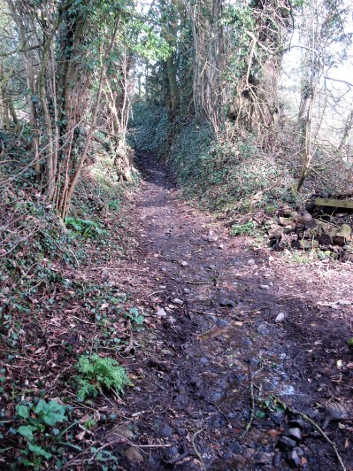
At its end, my map appears to show a footpath that runs right before ducking under the motorway. It doesn’t feel right, little used and overgrown. Himalayan Balsam is taking over. There is no obvious turning towards the motorway, and soon I’m heading in the wrong direction. A quick turnaround, still no sign of a motorway underpass. Is my map reading at fault, or is there really no path?
")
")
")
A closer look at the map later shows there was no way. 
I head back to the cottages. at Hill Foot Farm… 
…and use the road to Whittle Hills, another character house.
")
")
Then, according to my map, a farm track to North Bank Farm. Even here, the signing is confusing. I want the higher of the two motorway underpasses, A on the above map, so, ignoring the signs, I brave the farmyard and walk out at last; it seems to have taken an age to reach the other side of the motorway.

Under the motorway.
You may wonder why I have been so fixated on the map features and Rights of Way on this walk. Well, I’m into week 26 of my 52 Ways to Walk, at the longest day, – Walk with a map. I’ve been walking with a map all my life, only recently using phone OS mapping. So today I am relying completely on my paper copy of the 1:25,000 map, my phone consigned to the interior of my rucksack. I think I have an innate sense of direction, so I don’t need my compass to orientate me, it’s safely in the rucksack too, you never know. One has to constantly maintain a greater awareness of one’s surroundings, near and far, to correlate with the paper map, spotting features and signs to fix one’s position at any one time. I was lost earlier because I had misread the map – there was no continuation under the motorway from the first path.
The footpath now goes through fields, thankfully recently mown, and over some hidden stiles to emerge onto a minor road. 
")
")
Right in front is the track heading up the field towards Denham Hall, now all plain sailing and a joy to be out in the countryside. 
")
")
More fields take me to Walmsley Fold, busy with modern machinery.’ Fold is a common name on the map in these parts, originally an animal enclosure which grew into a farm or small community. 


A quiet road reached Top o’th Lane, a row of cottages originally built around 1800 for quarry and handloom workers. The loom room windows in the basements. They have a fine view across to Great Hill and the western Lancashire Pennines.
")
")


It’s good to be up high looking out over Preston, the Bowland Hills and Pendle, 


But then I find myself in a large field full of frisky cows paying me too much close attention, not so pleasant. I back off carefully until I can escape via a stile into Brindle village.
")
")
")
")
")
I wander into St. James’ church. Its tower is from about 1500, the naive C19th, with many changes over the years; Paley was involved, as usual. I am immediately struck by the amount of stained glass. Every wall has large windows. 
")
")
")
On the edge of the village is the Old Smithy and next to it the Parish Pound. 
 I’m sure there is more to explore in the village, but it is time to get going; the day is heating up. Heading towards Hoghton Tower, which can be seen on its hill in the distance. I navigate through fields and country lanes, possibly using my own variation of the Whittle Wander.
")
")
")
")
")
")
I come out onto the main road at Riley Green, next to the Royal Oak.
I could finish here, but I want to complete the loop around Hoghton Tower and the River Darwen. I have described this in more detail when I last visited here on a similar walk. I’ll make do with a few pictures today.
")
")


Whilst I am taking the photo of the Giant Hogweed, a Kingfisher flashes by – wow. 
And then I’m back at the Royal Oak for a quick half before catching the bus back to Preston. 
The Whittle Wander wanders off back to the start via Wheelton and places, but I’m leaving that half for another day, hopefully it will be as interesting as today’s walk. Won’t be just yet, though, as the heatwave settles in.
***


 The outcome.


 Getting comfortable with my skin damage is still a big problem, but my general mobility is improving quickly, especially as I now have more freedom to exercise. I’ll be down to the shops tomorrow.


 The temperature is hovering just above zero, but we must be under a high pressure there is no wind and the sun is shining. Perfect. I don’t carry a camera for these two days, I’m trying out my new phone.


 Jim led us out into the reserve, and we had only gone a few metres before he stopped on a grassy verge. A keen eye was needed to spot the tiny fungi, Blackening Waxcaps, They slowly revert to a black mess. I would have walked straight past them or even worse squashed them. The more studious followers were making notes.


 I’m tempted to go off down Fernyhalgh Lane past the old school (where my children started) the church and Ladywell Shrine, a shortcut back to Savick Brook. But no, I need the mileage and the day is fine, so I continue on the road whilst it is virtually traffic free. There are some fine houses along here as well as the original farms.
 Crossing the M6 motorway I stop to watch the southbound lanes coming to a standstill., a well-known black spot. Preston Bypass, as it was known then in 1958, was the first motorway to open in the UK. Since those days it has been incorporated into the M6 with new junctions and carriageways. I try to avoid driving on busy motorways with their frequent hold-ups and after my frightening experience of breaking down last year on a ‘smart’ section of motorway that has been reinforced.


