This turned out to be a bad day for myself, whom I took to be an experienced walker. No one else has that assumption. Having become interested in the Wyre Way, which I had encountered further up near its source I ‘planned’ a few days walking its 41 miles. Today I intended to explore upstream from the river mouth at Knott End/Fleetwood. Buses were taken from St. Michaels via Poulton to deliver me at Knott End on a beautiful sunny day. What better relaxing way to start the day than with tea and toasted teacakes in Knott End Cafe. This building was originally part of the station at the end of the Garstang-Knott End Line and has many interesting old related photos on the walls. Eventually I set off as the ferry was coming across the Wyre from Fleetwood with the Lakeland Hills in the background.

Knott End Ferry.
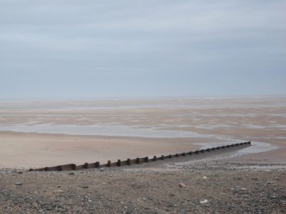
I had hit upon low tide and as this exposes lots of mudbanks the river did not look at it’s best. Flocks of waders were feeding at the edges, mainly Dunlins and Oyster Catchers I thought. Crossing a golf course I arrived in seaside bungalow suburbia which I found difficult to navigate out of. No signs for the WW which I thought would be in abundance, I only had with me the old 1:50000 map and I had not marked on it the line of the route. Big mistake no.1. Soon I was out into the fields on a good path which eventually deposited me off route in Preesall on the main road I had just travelled. No problem I connected via paths back to the coast and onto the sea ‘wall’ A minor Burrows Lane, never met a car, was followed to the yacht mooring’s at Wardley’s Pool.

Mud births at Wardley’s.
From here I had a run-in with another holiday park which I felt lucky to escape from to the river again. The path now seemed to follow the marshy waters edge towards the new Shard Bridge. Sea-lavender was very profuse and colourful on this stretch. After all my delays the day was passing and the tide was coming in once more – had never given that a thought. Big mistake no. 2. Reached the Shard Bridge pub with dry feet just!
  The last time I was here there was still the old toll bridge and it always seemed a bit of an adventure to visit this pub. Was glad to find they were serving Bowland Brewery ‘Hen Harrier’ on draught so I relaxed over a pint in the sunshine on their patio overlooking the river. The route was signed straight from the pub along the water’s edge and I stepped straight onto the, by now waterlogged, path. Big mistake no. 3.
Things became quickly worse as the tide rose further and I was fighting my way through sea grasses in a foot of water. By now there was no sign of a path and survival became uppermost on my mind [but strangely not to turn back]. When my floundering in the water became dangerous/comical I managed with difficulty to scale the brier and nettle covered embankment and threw myself across the barbed wire fence into the sanctuary of the higher field. Trespassing along the first field boundary was no problem but having yet again climbed over barbed wire I now found myself in a head high maize crop – jungle warfare.  This repeated itself for many a field with only crop rotation providing easy or difficult progress. Nothing fit on my map [without field boundaries] and the afternoon became hot and sticky. Salvation seemed to be close as I reached a recognisable farm on the marsh edge. Stopping to ask for advice I was immediately attacked by two overgrown ‘pit bulls’, a mastiff and the usual terrier. The farmer came to my rescue, of course saying they wouldn’t bite me. We ended up having a pleasant chat about the area, the river and the fact that the tides had been at their highest. He reassured me that as now the tide was retreating there would be no problem following the path through the marshes. So on I went, now with the occasional WW waymark there had been none before as I was mostly off route. Stopping to check my position I realised I had lost my fairly useless map but I thought I could manage without it now the going was easier with occasional way markings. Big mistake no. 4. The walking across the marsh was indeed easier for awhile. Jellyfish were a common sight either high and dry or isolated in saltwater pools.
 Before long the path became overgrown and I was once again fighting through reeds, tripping over and generally lacerating my legs and pride. The occasional tantalising waymark drew me into worse territory.
  It was with relief that I staggered onto a road. By now my sodden boots and socks seemed to have dried out! The lack of a map meant I couldn’t pick up any WW footpaths and none were signed so I trudged along the riverside lanes. The last mile I was able to take to the river defences for a pleasant walk into St. Michael’s, the river now contained between the fields.
I finished battered and bruised at the bridge over the Wyre next to the church and close to the Grapes Inn where I enjoyed a Timothy Taylor ‘Landlord’ as payment for my parking all day in their carpark. 

Cottages and pub St. Michaels.
I’m sure I made even more mistakes than highlighted above but the day has turned out to be quite an adventure and once I’ve bought another better map I will continue on the Wyre Way. One bonus of today I have not mentioned were excellent views of the Bowland Hills across the Fylde. It is in these hills River Wyre originates and where I will be heading towards next.
As a postscript, I do have to comment that the route is not well waymarked and apparently little walked.
 Wednesday 2nd December. 6.5 miles. Great Eccleston.


 At last, I was on the embankment and following the Wyre downstream, a popular route for dog walkers. Walking around the loop was fast and easy which was needed as the sun was beginning to set.

 I had time to look at the Cartford toll bridge and the adjacent pub which has been modernised since I used to drink here 40 years ago. More rainbows appeared with the passing showers.