 *****
*****

The green area on the above map is the County of Lancashire which as you may well know has, as of this last weekend, gone into the highest Covid-19 restrictions – Tier 3. So my wanderings in the foreseeable future will be solely in the Red Rose County. There are far worse places to be. As it happens I was already planning to visit Abbeystead today for a walk plucked out of Jack Keighley’s Cicerone ‘Walks in the Forest of Bowland’ guide which seemed to have several points of interest. I’ve been following quite a few from this guide in the last weeks and have been impressed by their quality. The forecast is for cloud so a low level walk suits.
*****
I arrived at the carpark at 12noon to find it full, I’d half expected that. Fortunately a couple of early birds were just finishing their walk so I grabbed their spot. The River Wyre has two initial tributaries, The Marshaw and The Tarnbrook. I started my walk alongside the latter and soon came to the former. My curiosity had me bashing through the undergrowth to find the confluence of the two – a Dr. Livingstone experience. The two small streams meet and soon the River Wyre takes on a more majestic flow. Satisfied I go back to where I had started, it’s going to one of those days.

Marshaw Wyre bridge.

Meeting of the Waters

The Wyre flows on.
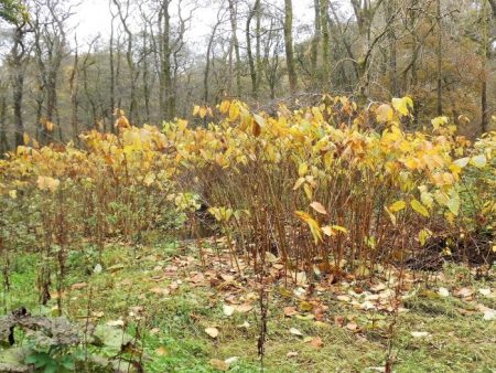
I took some photos of these large plants growing profusely along the banks – I don’t know their name? I thought the leaves were too large for Japanese Knot weed but I’m not so sure now.
 My path left the Wyre Way and shot up some steep stone steps which kept on going. Eventually fields followed to come out onto the road at Hawthornthwaite with the fell road heading across to the Trough of Bowland just above me. All around were the Bowland Fells looking a bit dismal today.


The mole catcher has been working overtime.
A farm track took me past Marl House and then into open fields with no obvious track. For this walk the guide states “A somewhat complex route requiring careful reference to map and directions” Well I was soon searching for the next stile and essential footbridge across a formidable little gorge, Cam Brook. Walking up and down my GPS didn’t seem to be helping. I persisted with my search and finally found a new looking bridge across but not where shown on my map. Anyhow, I was across and climbing fairly new steps but at the top where I should have gone right to an old mill a new pheasant fencing blocked my way and shepherding me upwards. I tried an open space in a hollow but at its end a high gate. I could see no path continuing, so I decided to head for a barn shown on the map and follow the track from there. 


 As I walked on I spotted three walkers coming the other way towards where I should have been. After pleasantries with them, I set forth or was that back, determined to find the mill ruins. After a couple of stiles I came across them in the woods, sad reminders of a bygone time. It had been a water driven cotton spinning mill until destroyed by fire in 1848. Associated workers’ cottages were disappearing nearby. That hollow I had been walking in half an hour ago was in fact the old empty mill pond.


Satisfied I returned to pass again the cheerful three sat on a log having lunch.

Last of the summer wine.
Now I knew where I was going – Little Catshaw 1763 and Catshaw Hall 1678. I passed through here before with Sir Hugh on our straight line walk from Longridge to Arnside in November 2018.

Little Catshaw.

Catshaw Hall.
The steep track led down over a sparkling side stream and to the Wyre in its heavily wooded valley. A sturdy bridge was crossed before stone steps went straight up the opposite hill to Lentworth Hall. These tracks must be centuries old linking farms and maybe going to the church where I was heading.


More stone steps.
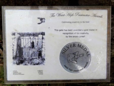
A gate at the top of a field, suitably full of sheep, admitted me into the churchyard of Christ Church, The Shepherds’ Church. [The gate has its own story which I thought was a joke at first] The church dates back to the C14th but was rebuilt in 1733 and a spire added to its tower later. Its stained-glass windows depict Biblical shepherd scenes, these would have been better appreciated from the interior but it was locked. In the porch are rows of hooks supposedly for visiting shepherds to hang their crooks. Above the door is an old inscription – ‘O ye shepherds hear the word of the Lord‘


 I found a bench to sit on for lunch, it was 2.30 after all. Next to me was a war memorial with a thought-provoking inscription perhaps aimed at the agricultural soldier.

My next objective was a Friends Meeting House and Quaker burial ground up the hill at Brook House. As well as the meeting house there had been a school and schoolmasters house in this little complex of buildings, now residential conversions. The graveyard with its simple uniform headstones was accessible and was a very calming place. Apparently the Friends Meeting House In Lancaster has use of it but there didn’t appear to be many recent burials.

I was now quite high on the northern flanks of the Wyre Valley but views were limited by the weather. More fields took me past Chapel House Farm with its barking dogs and over a rickety stile to the road at Summers House.

Then a walk across rough country in worsening light to Grizedale Bridge over the Tarnbrook Wyre. A cart track was followed back to Stoops Bridge.

Grizedale Bridge.


Stoops Bridge.
Before I got my car I had a wander into Abbeystead itself. All the C19th buildings are now part of the Duke of Westminster’s vast estate and built in an Elizabethan style. The big house is hidden from view. The hamlet is named after an Abbey founded here in the C12th by Cistercian monks from Furness. It didn’t last long and was soon abandoned.


All I needed was a bit of sunshine to bring out the Autumn colours.
For a walk visiting the reservoir and dam itself have a look here..
*****


What a lot of interest packed into that one. I admire your zest for exploration: going to the “rivers-meet” and the like. That message for the shepherds would have been more appropriate today with the name of Dominic Cummings?
That old Bowland Cicerone guide is proving very useful, particularly with the ‘lockdowns’ – and a bit of extra exploration spices things up.
What a fascinating and beautiful walk. Definitely makes me want to go. Love all the agricultural connections with the church and the war memorial.
Terrific area for pottering about. The walk could easily be split to highlight the second half.
From parking in Abbeystead use the Wyre Way past a lake then go up to Lentworth, church and meeting House. Then little lanes back.
Excellent, Bowland. Lots of interest. Tempting for us to stray from Greater Manchester (as I think we will be on Friday).
Thanks Martin.
Welcome to the Third Tier.
Thankfully I have loads of choice within Lancashire.
I know the area around Abbeystead a little, or rather I should say I’m familiar with struggling around the paths of Abbeystead. A gorgeous lost world but I find navigating across it is always a challenge.
The farmers don’t make it easy for you in this part of the world. A little yellow arrow would cost nothing.
I do like a bit of alliteration 🙂 I’ve often wondered where the River Wyre started, now I know. Poor little moles, why do people hang them on fences like that?? 😦
I’ve heard it said that it is to do with the molecatcher getting paid. A tally of his catches.
Thats true, I ended up blundering through one owner’s garden by mistake because they’d “disappeared” that little arrow. They weren’t impressed and quite rude, inspite of my humble apologies.
I’ve never understood the mentality of landowners, of whatever genre, with rights of way across their property not wanting to direct one through as quickly and efficently as possible.
A subject I may bring up on the next occasion I’m confronted with being ‘off course’
Fascinating to see grand places I don’t know.
I’m afraid Lancashire is out of bounds for you now John. Just as the Eden Valley and Northern Pennines are for me unfortunately.
It would be nice to think it all might work, but I somehow doubt it.
Pingback: Abbeystead Weir – Northwest Nature and History