Monthly Archives: June 2023

CICERONE’S LANCASHIRE – GRAGARETH’S MEN.

P1020312 (2)

Well there were JD and me, the three scientists doing a peat survey for some research organisation, the Three Stone Men who have been there for who knows how long, and a few others stone ones scattered around. The peat survey was interesting as we are just waking up to the importance of peat as an important carbon storage resort. We were happy to sit in the shelter of the Three Men as there was a distinctly cold breeze coming from the Northwest. A good opportunity to take a break and eat our sandwiches.

Our journey up the motorway had not been straight forward as I missed the turn-off to Caton and the Lune Valley. Another junction farther north and JD’s phone chose an alternative route over towards Kirkby Lonsdale, although eventually on the A65 we ignored the lady navigator and followed the sign up to the little hamlet of Ireby.  I shall not reveal where we parked, but there should be space by the telephone (book) box. Surely we are in Yorkshire by now, but no the Lancastrians have pushed a finger into Cumbria and Yorkshire.  We are in fact out to climb the highest (allegedly) hill in the Red Rose county, walk number 16 in Mark Sutcliffe’s Cicerone guidebook.

Up to now we have been walking on a distinct lane out of Ireby and then the tarmac road heading up the fell from Leck. All easy going, gaining height almost effortlessly, at least we could keep up a good conversation without getting out of puff. JD is super fit at the moment having recently completed a pilgrim route to Santiago, a Scottish trip and The Dales Way. I was hoping that his all-inclusive hotel stay in Menorca with his wife might have slowed him down. We are in limestone territory. P1020289P1020292P1020298

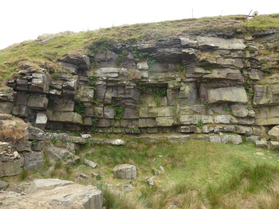
This road leads to a remote sheep farm. I used to park up along here for exploring the nearby Leck Fell potholes. Short Drop Cave was always a favourite, lowering yourself in with your feet dangling in fresh air in the darkness, dare you let go of the rock? Of course, you did and only dropped a few inches! You could explore the channel for some distance and then worry about getting out again. But today we were heading up to those stone men visible on the hillside above. Conversation dwindles on the steepest scrambling bit, look at the contours, and we are all too ready for that rest at the Three Men. P1020305

P1020310

The Three Men.

P1020321

The Three Ladies.

P1020315

Lunch over we chat to the peat surveyors before strolling the last section to the lonely trig point on Gragareth, 627 m, the highest in Lancashire. Now this is where some debate comes in, farther north across the barren moor is Green Hill, still in Lancashire, and marked on the OS map as 628 m. We don’t fancy the two-mile boggy trudge up there. But help is at hand – in 2014 the Database of British and Irish Hills suggested  “Gragareth replaces Green Hill as Lancashire county top”.  Gragareth having a height of 628 metres, 100 metres east of the trig point, while Green Hill is 627.5 metres. Who knows?  P1020324

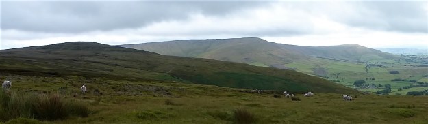
Anyhow, we slink off along the wall southwards. But I have forgotten to tell you about the views from that highest point. Morecambe Bay, Lakeland hills, nearby Barbon fells, all those rounded hills up to Dentdale, Whernside and of course stately Ingleborough, distant Pendle and the Bowland Fells, quite a collection.

P1020323

Northwards.

P1020334

Whernside.

P1020329

Ingleborough.

On down along the wall and then a vague path down to the ‘Turbary Road’ above Kingsdale, a track used by peat cutters – yes we have been destroying the land long before climate change was thought of. This area is full of caves, potholes and dry riverbeds, but the way missed most of them out. On reflection a few small diversions to peer into these limestone features would have added interest. P1020331

P1020338

P1020339

Marble Steps Pot.

P1020345

Twistleton Scar End.

P1020344

Turbary Road.

Once on the lane we made good progress stopping only at a bench for a drink, out of the vegetation crept a giant dung beetle. P1020348

Masongill looked delightful.P1020349

Freshly cut green fields, and we were soon crossing the ancient clapper bridge into Ireby.

P1020350P1020353

It was good to be back in Limestone Country, as you can see the weather improved as the day went on. Eight and a half miles with 1700ft of ascent – I’m still thinking imperial.

***

CaptureGragareth (2)

CICERONE’S LANCASHIRE – ?FORBIDDEN BOWLAND.

P1020180Sat alone on the isolated true summit of Fairsnape, deep in Bowland, I’m poking at one of my sandwiches, egg and tomato, made a month ago. They went into the freezer when hot weather and circumstances cancelled an outing at the last minute only for them to re-emerge this morning. there is a distinct unappetising taste.  Should you freeze hard-boiled eggs? I’ve just traversed some of the loneliest hills up here and am in need of some sustenance.  The morning has been misty on the fells, however with a welcome cooling breeze. Distant views are restricted from my lofty perch, most of you will never have been here. Only a few curlew and grouse share my space. I poke again at the sandwich and decide to toss it into the heather for probably the seagulls, who now also patrol these heights, to scavenge.

As I say the day started off murky and cool with low cloud, quite the opposite of the mini heat wave we have been enduring. Ideal for a tramp across these Bowland hills. For a start don’t take Mark’s advice to leave your car in the Delph Lane car park, it’s none too safe and leaves you with quite an uphill walk before you start. There are suitable lay-byes nearer Stang Yule. Walk number 2 in the Cicerone’s Walking in Lancashire  book.

The way starts at a gate leading onto open access land. Welcome. On closer examination a notice says ‘No open access – temporarily closed at the land manager’s discretion’ Not a  good start at all. But wait, the date is 2021. This sign has not been removed or updated for two years. So much for the land manager.

P1020163P1020274

I try not to read too much into this as I stride boldly onto the access land. Nobody will see me in the mist. I’m enjoying the heather under foot, there is a path of sorts but not many come this way, put off by that notice possibly. Slowly I gain height and pull away from the plantation onto the open fell side, A track takes me across the slopes of Hazelslack Fell, a rarely visited spot. The last time I was up here was with Sir Hugh and JD on our straight line adventure between our homes. It’s as remote as I remember. P1020165

P1020169

The views back to the Fylde are supposed to be good.

P1020183

Approaching Hazelhurst Fell.

P1020186

Looking back with the track skirting below the summit of Hazelhurst.

I don’t bother with the 429 m trig point this time as I’m probably going higher shortly. The track dips down and climbs the contours gradually onto Winny Bank. The raison d’être for this track becomes obvious with the appearance of shooting butts. Not only the butts but also the small mammal  traps, thankfully decommissioned. The highlight of my week, if not the month, was witnessing a family of Stoats crossing a road on Longridge Fell. Distinctive with their black tipped bushy tails. Who would want to trap and kill these beautiful animals?? P1020188P1020189P1020197

Along the way is a stark memorial to airmen lost on these hills in WWII, I have a book somewhere  listing all these crashes and giving their accurate sitings. P1020196

The track starts to descend, and I have to be alert to pick up the ongoing path to Fairsnape otherwise I would be floundering, I know not where. The path begins somewhat unlikely with a few steps leading off a turning place. The stone flags don’t go far and one is left following intermittent white posts through the morass of peat. You will be glad you came here in dry weather, preferably a draught, also not a good place to be in thick mist. Stick with it, and you will arrive at a fence corner euphemistically named  Webster’s Meadow. (if you miss it you would be in ‘Dickey’s Meadow’) This is also known as Fiensdale Head, the way through from Langden to Bleasdale. A partially flagged path shows the way. it’s a long time since I’ve been down Fiendsdale, a good spot to see ring ousels. No idea who Webster was or Dicky for that matter.

P1020199

Turning spot.

P1020200P1020201

P1020205

The way down to Fiendsdale.

United Utilities have an information board explaining the work being carried out to try and reverse some of the peat erosion. When I was last up here they were helicoptering bags of stones in to be incorporated into ‘dams’, stopping further erosion from run off and re-wet the surrounding peat. Evidence of that work is all around with stone and fibrous matting in the peat cloughs. One does wonder how much we can do to repair the damage which must be on a vast scale in Bowland alone. Are you still able to buy peat based compost – I hope not? P1020204

P1020214P1020216

A few more flags are encountered, showing a way down to Bleasdale and ahead to Fairsnape. Then you are on your own again with the fence for company. The book talks of ‘hard going’ in the peat hags – ‘hopping over to the other side of the fence may help’ Today that is not necessary as it is as dry as it is going to get, but there are still boggy morasses you wouldn’t want to fall into, perhaps the re-wetting is working. Knees are allowed for climbing out of the deepest hags. P1020213P1020208P1020221

Anyhow, I’m soon sat at the 520 m summit contemplating my lunch. There is another informative board up here telling the same story. Some of the funding came from the EU, pre Brexit. How much will our own DEFRA run by Thérèse  Coffey put into environmental schemes? P1020222

It’s a dry run over to the other summit of Fairsnape, the one with the shelters and trig point. I’ve not seen anybody all day so far and can’t believe I’m the sole person at this popular top. Only when I get closer to the shelter do two heads pop up – a young couple having some private time to themselves. P1020228

The mist has lifted a little allowing the gliders from the club down below to take to the thermals, spookily and silently sliding past out of the thin cloud. P1020226

The way off, by a cairn, is down some zigzags into Bleasdale. I have always assumed these to be part of a sledging route for bringing cut peat off the fell. Beautifully constructed and a joy to walk whichever direction, up or down. Few people used them as most are linking Fairsnape with Parlick along the ridge. But Mark knows this area well, covering Bowland in detail, the secret is out. P1020230P1020232P1020241

P1020243

P1020259P1020273

What a contrast from the northern side of the fells – endless peat and heather as far as the eye can see and down here in Bleasdale with the green pastures stretching to Beacon Fell. The guide book takes you on tracks that would give access to Bleasdale Circle, but I’ve been there many times and at the moment it is a bit of a mess following storm damage to the trees, so I take a slightly different route through Bleasdale, past remote farms, past the old reformatory school buildings and past Bleasdale Tower. North Lancashire Reformatory for Boys, Bleasdale, near Garstang, Lancashire (childrenshomes.org.uk)

P1020278

That little lay-by.

The little blue car was waiting for me in that lay by, as a Duke Of Edinburgh group were going through, staggering in the heat under massive rucksacks. I wonder who had the better day?

***Capture Hazelhurst (2)

TOMORROW STARTS TODAY, A LONGRIDGE LOOP.

P1020116 (2)

It is a month since I have done a ‘long walk’. Health issues combined with all that heat kept me in doors. I’ve only managed a few walks of a couple of miles or so, enjoyable nonetheless in their own rights. Tomorrow I hope to take up the cudgel of another possibly strenuous Cicerone’s Lancashire walk. So I had better have a gentle warmer up to get my legs back into shape.

From my header photo you can see that the hawthorn flower has given way to the elderberry.

Juggling with the weather I need to get going before the afternoon rain comes in, our gardens need it. (it never arrived)

Let’s keep it simple and walk up the lanes from the village onto Longridge Fell. I’m only out for the exercise after all. Park at the little reservoir, Upper Dilworth, stop to watch the female tufted duck with her brood and then a brisk walk-up past the golf course onto Jeffery Hill. I can’t resist a look into Cardwell Quarry to see if the barn owl is still there. A couple of weeks ago I looked in and took a hurried photo of the roost which showed up the owl’s legs but nothing more! Today nothing at all. I sat for a while taking in the view over Chipping Vale and remembering all those summer evenings climbing up here with Longridge mates. It’s banned now due to some unfortunate contretemps between the landowner and some selfish youths. It doesn’t take much to destroy all the goodwill built up in the past. P1020112P1020115P1020128P1020130

P1010903

Two weeks ago – spot the legs.

Close by here the Roman Road was thought to have come up from Ribchester before a turn to head through the hills towards Newton, and then over to Lancaster. It is marked on the OS map, and today I can make out the line of it just below the modern road. P1020119

P1020132 (2)

Surprisingly there is only one car parked up on Jeffrey Hill where the walk-up onto Longridge Fell starts. I never meet the occupants. Taking the ‘balcony path’ along to the spring and then heading towards the ridge, it is bone dry. I am tempted to carry on up to the trig point, but sense tells me to go easy and besides I can see rain coming in across the Fylde Coast. Back down alongside the wall, past the ‘grim up north’ tree. 

P1020125

P1020134

Straight across and alongside the upper trees of Cowley Brook Plantation. This plantation is becoming a favourite of mine for an evening stroll, and today I cut down through it meeting up with the brook where it disappears under the road. P1020137P1020138P1020140P1020143

This road takes me eventually, there are lots of ups and downs, back to the village, passing the lower side of the manicured golf course this time.

P1020155P1020156

P1020158

Job done, now let’s see what the forecast is for tomorrow.

CaptureLOngridge Fell.

A SHORT WALK FROM HURST GREEN.

P1010994 (2)

***

I was deterred by these signs on what I thought was a right of way the other day. I didn’t have a map at hand, so I opted out and walked up the lane. There is a hidden side to Hurst Green, large expensive properties guarding their privacy, but public footpaths shouldn’t be lost or walkers intimidated. Officially all Public Footpaths should be signed where they leave a public highway but speaking to officers on the Local Authority these signs regularly disappear. P1020010

The morning’s heavy rain has passed, and I’m back armed with the latest 1:25,000 map and approach from the other end near the old bobbin mill on Dean Brook. There are predictably no waymarkers, but the start of the path is clear above the Brook. I walk past properties that were probably mill workers’ cottages in the past and soon come out onto the lane, The Dean, which drops from the village crossing the brook and climbs back into the countryside. Curiosity satisfied I’m on my way. P1020006P1020007P1020008

The quiet road heads upwards with views over the Ribble Valley opening up to the south. I know there is a path somewhere leaving it to climb Doe Hill , but I can’t find it initially in the heavy vegetation. Is that it, hidden away?

P1020012

The Ribble Valley.

P1020013

There is a stile in there somewhere.

Once into the field I can see the trig point, Doe Hill, one I’ve never knowingly visited before, a short distance away. More interesting is the nearby clump of beech trees, maybe 30 or 40, all growing as one. How long have they been here – a couple of hundred years or more? There is a vestige of a wall enclosing them, who planted them and why? A magic place, I half expect a troupe of fairies to be dancing around., it is  the summer solstice after all. Whatever it is a good viewpoint – Longridge Fell, Pendle and the Ribble Valley. P1020017P1020020P1020024P1020028

P1020035

I pick my way across fields full of buttercups, finding stiles in the appropriate places and come back out onto the lane heading to Greengore, a C16th hunting lodge for the Shireburn family, which I’ve photographed many times before. There appears to be some building work going on at an adjacent barn, let’s hope it doesn’t distract from the Grade II listed Greengore property. P1020037P1020038P1020040

I knew of the sturdy bench at the junction of lanes and was glad to sit for some refreshment, it was still a very muggy day. The lane dropping to Dean Brook, yes the same one, is bordered by hedges full of roses and honeysuckle, with foxgloves pushing through the bracken. P1020043

P1020045

P1020041P1020044P1020046

Crossing the bridge I am reminded of bringing my children and then my grandchildren here for the simple pleasure of ‘pooh sticks’. Even today I can’t resist dropping a stick upstream and watching it emerge farther down. P1020048

Hidden away just off the track is Sand Rock, all that remains of a large sandstone quarry  used in the construction of Hurst Green Itself. I divert here to see if my lost favourite orange cap is anywhere to be found, I last had it on when I came looking in here at the rock face a few days ago. Some lower boulder problems are chalked up, evidence of recent interest. We climbed a route up the middle of the quarried face, Vanilla Slice E2 5c, in 2002, it looks impossible to me now. No sign of my cap. P1020054P1020050

Onwards alonside the brook cascading down the soft sandstone rocks which have been smoothed into  beautiful curves over the ages. Plainly visible today are the remnants of the dam footings and ongoing leat supplying the bobbin mill farther down valley (where I started my walk today). P1010981P1010983

***

I’m back at my car after this short, 2.5 mile, but interesting exploratory walk. The black clouds have blown away, and the sun is beginning to come out. I have another site I want to look at, the Stonyhurst Roman Catholic cemetery just up the road. I’ve always been fascinated by the mausoleum type chapel visible through the railings from the roadside, but never visited. Going through the gates into the cemetery one is immediately drawn to a white statue of Christ with Pendle as a backdrop. The cemetery is laid out with mature coniferous trees forming stately corridors between the many vaulted graves. The Mortuary Chapel is dated from 1825, but I can’t find out if it is dedicated to any particular family. Does anybody know more details? P1020056P1020002

P1020058P1020062

P1020076P1020069

P1020063

Detail from a window.

P1020064

Through a window, showing it to be a chapel rather than a mausoleum.

***

CaptureHurst Green. (2)

NEW WAYS ON THE EAST END OF THE FELL.

P1010924

The heat goes on, we somehow have avoided the thunderstorms rattling around the North West. Lethargy is the order of the day. But there is a breeze from the east, so some solace may be found up on the far end of Longridge Fell. Not again I hear you say that’s the third time in a week up there, but I’ve approached  from three different but well-used directions.  The lethargy prevents me going farther afield and the heat limits my delicate body’s distance and exertion. And anyhow I like my local fell. 

When I moved to Longridge over 50 years ago few people used the fell for recreation. The forest tracks were constructed, but I don’t think the public were encouraged onto the land. I remember the spruce trees looked relatively young, as was I at the time. A few public footpaths criss-crossed the once open fell sides which must have been planted up in the late 60s to 70s. The 7th Edition, One inch to the mile, map of 1969 shows only a few scattered plantations with no forestry tracks. There was a way up from Jeffry (Jeffrey) Hill to the trig point, then 1148 feet (now350 m) but few went farther along the ridge. This involved for  the most part delicate, muddy and pathless walking between the young trees. 

CaptureLOngridge fell 1964

Compare with the modern map.

CaptureLongridge fell

Over the years, thanks to intrepid walkers, a path developed along the ridge from the trig point all the way to Kemple End where the fell drops steeply to the Hodder. This was mainly in the new forest planting and could be very muddy in the winter. Mountain Bikers started using the forestry tracks and signage eventually appeared on the public right of ways. Old walls started to crumble but were still good orientation points. It has now become a popular walking and cycling destination. But come full circle and some areas are being harvested and the devastation that that brings can often wipe out the unofficial paths that had developed. On top of that recent storms have brought down many trees and affected paths can be difficult or impossible to follow. Clearance is for some reason slow paced. 

My planned walk today would complete a trilogy of routes up Longridge Fell, from the West, South and now East. I would be walking some of those ‘unofficial’ paths and encountering both forestry and storm damage.

From the rough parking at Kemple End the main forest road traverses the fell, but I want to see how the little path in the trees to the north had survived. Starting on the left, SD 689406, down the road from the parking. The path looks well-used and the few trees that had blown down seem to have been cleared, all very promising. Buzzards circle overhead and blue butterflies flit around my feet. There is not much breeze although most of the time I’m in the shade. Steady progress uphill. At the first junction I know I could go left and regain the main forest road, but I go right to keep to the ridge. The path narrows and is enclosed in the trees, I recognise familiar landmarks. Before long though it comes up against some forestry work from a couple of years ago, a large area of felled trees on the northern scarp. People have escaped back left to the forest road. and that’s what I do. After 200 m on that road I spot an orange arrow on a tree at the edge of the destruction, is this a way back to the original path? After some haphazard wandering through orange dotted trees I give up and escape into the felled area onto a track of sorts used by logging vehicles. It leads me in the right direction westwards close to where the old path ran and if people use it will become an established way. Somewhere at the end where it joins with a forest road, more felling here, used to be a viewpoint (Sam’s View, I never found out who Sam was) but with new growth on the scarp it is no more. All in all a right mess. The latest OS map no longer tells the truth.

P1010916

A good start.


P1010918

Pushing on.


P1010922

The old way through the trees on the ridge…


P1010931

…soon disappeared in forestry devastation.


P1010933

New trees have already been planted.


P1010945

Orange hope?

P1010938

Sam’s view?

I don’t feel like tackling the still obstructed way up to the trig point so simply follow an established path down to the forest road. I turn left and saunter back down to the car with the bulk of Pendle ahead. 

P1010940

No farther.

P1010941

Escape path.

P1010944

The main road.

P1010946

Proud Pendle.

Last year there was a good crop of orchids along here but nothing to show at present. The Bird’s Foot Trefoil, Mouse-ear Hawkweed and ‘Fox and Cubs’ are all flowering.  What delightful traditional countryside names.

You may wonder why I’ve not yet included a route onto the fell from the north, well have a look at those contours. Longridge Fell is a ‘cuesta’ with a steep escarpment to the north and a gentle slope to the south. I have come up from the north many times but any ascent at the moment would be punishing in the heat. I will leave it to you to plan your own way up those footpaths from the Chipping side. 

I fear for the fells as we have had no rain for weeks. One careless cigarette or a disposable barbecue, the weapon of choice for moorland fires, and we will be loosing a valuable habitat once more. Go careful out there.

***

  Capture Kemple End..JPG


CaptureESRI

Latest ESRI.

LONGRIDGE FELL – THE TRADE ROUTE.


20230610_150136 (2)

Every fell has an easy and hence popular way up it. The Victorians talked of ‘Tourist Routes’ up the Lakeland Fells, I have a copy of a 1960s Baddeley’s Lake District, a Ward Lock Red Guide aimed at the new tourist who wanted to explore the fells without any serious mountaineering. Wainwright popularised the fells, but give him his due he did seek out the less populated ways. A trade route or tourist way is the most frequently used route for ascending and descending a hill or mountain. Farther afield the term the “Yak Route” was used for climbing Mount Everest on a commercial expedition, you have seen the pictures of the queues on the South Col.

Well I’m not in the Himalayas or even the Lakes but on the humble Longridge Fell. I’ve been up it three times this week already, it’s in my backyard so to speak, trying to build up my fitness again after an enforced lay-off. There are three main entry points for climbing the fell. a path from Jeffrey Hill car park, my usual way. The forest track up from the lower fell road parking above Crowshaw. And the forest track from Kemple End at the far end of the fell road. Judging from the amount of cars parked up the middle option is the favourite, a simple march up the made up and wide forestry track.

So that was my option today,the hottest of the year so far. Despite my stating this to be the most popular way there were very few people about. Too hot for most and down in Longridge it was field day. Field days years ago were a community gathering, my children on many a themed float. A family day out. Nowadays, it has become a bit of a rebel rouser with the riot police usually in evidence later in the day. One to be avoided. English society has taken a downturn in the last decade. 

That links me into the ‘trade route’ up Longridge Fell. I almost changed the title of this post to ‘the irresponsible dog walkers’ route. I came across a dozen discarded dog poo bags within the first hundred yards from the road. And there were more sporadically as the track gained height. Trying to be impartial, who do these people, it’s not the dogs, think will clear up the mess? Not a good start to my walk. 20230610_150200

The shade I had hoped for was lacking due to recent forestry operations but once on the open ridge there was a cooling easterly. Before long I plunged back into the trees for the tricky section through windblown trees from the ‘beast from the east’, was it really 2018? Nothing much has been done to restore the path, in fact due to exposure more trees have come down since then. I’m beginning to know the best way through now. 20230610_151350

20230610_153638

20230610_154447

20230610_155203

Onwards down a track through naturally regenerating forest from harvesting a decade or so ago. I love this stretch past some of my favourite oak and beech trees. Although one of the ageing giants has fallen. 20230610_15591820230610_16061320230610_16064820230610_160955

If you know it there is a shady path back avoiding walking on the road. 20230610_145421

So a trade route up but a more adventurous way back down. Plenty of variety in three miles. Did I take any photos on my phone?  Just a few. I was glad I had some water to drink back at the car. It may thunder tonight, I hope it will. in fact, it is right now.


Longridge Fell.

A LITTLE LONGRIDGE LITTER.

20230605_144203

The gardening can wait. It’s hot and stuffy and my hay fever is irritating. Time to escape to higher ground not to far away. A quick lunch and I’m parked on Jeffrey Hill. It’s not rained for days and the ground is looking parched. What is usually a boggy path is now bone dry and trainers are all I need. There is a welcome breeze, and I’m soon ‘walking on sunshine’ with the familiar panoramic Bowland Fells stretching out above the vale of Chipping. Newly cut meadows adding to the patchwork. Yorkshire’s three peaks are in the far haze.

20230605_140336

All very idyllic you will think, but I also choose to do a litter pick at the same time. I thought there was less rubbish than usual on the path to start with, but by the time I’d completed my 3-mile circuit my sac was full. Dog poo bags, tissues, empty water bottles, cans and strangely a pair of underpants. I declare the fell litter free – but for how long?

20230605_144952

As an afterthought on the way home I called into our local bouldering Craig Y Longridge to check out any litter there. I’m pleased to say there were only a couple of bottles to remove and these had probably been thrown from the road above. Well done climbers for looking after their own environment. By now the crag was in the shade and I enjoyed a bit of exercise on some of the easier problems.

Back to the garden and those weeds. 20230605_173554

***

CaptureLongridge Fell