Category Archives: The Two Saints Way.

LAST DAY ON THE TWO SAINTS WAY.

Cannock to Lichfield.      7 miles.

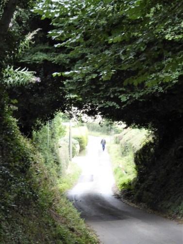
  My B&B host gives me a lift back to the Ring Circle Fort, and I’m on my way, downhill to Lichfield.  One was supposed to be able to see the cathedral from up here, but low cloud prevented that. There was good walking up on Gentleshaw Common and then old tracks through woods to come out onto quiet lanes to sleepy Chorley.

Back into the fields I came to Farewell Hall and the Church of St. Bartholomew built on the site of a priory.

For the next two miles I walked along the ancient Cross In Hand Lane, so named from the wooden cross pilgrims would hold as they approached St Chad’s Well. This lane was a joy to walk, in places hewn out between sandstone banks and in others with mature hedges. A scattering of farms were passed along the way, and at the bottom of the last hill a cave reputedly used by Medieval candle sellers to pilgrims.
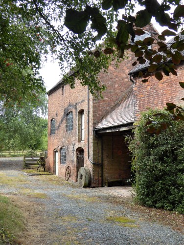
Medieval cave?

Lichfield was entered alongside the old Pinfold, which has been recently restored.

The house belonging to Erasmus Darwin, the Physician and naturalist and Charle’s grandfather, is now a museum in the shadow of the cathedral. The man himself was looking out of a window. There are many fine houses in Lichfield which is worth a longer visit.

At last the three unique towers of Lichfield Cathedral were seen as I approached the magnificent entrance. A Saxon church was built here to house the bones of St Chad, to be replaced by a Norman Cathedral, the present Gothic structure dates from the 13th and 14th centuries.  One walks down the beautifully vaulted nave, through the chancel and there in front of you is the shrine of St. Chad.

Behind in the Lady Chapel are the famous Herkenrode stained-glass windows rescued from Belgium. St. Chads Head Chapel was closed to the public.

Two relics related to St Chad were on display —  The Lichfield Angel,  a beautiful limestone carving from the chest that contained his bones. The 8th century St. Chad Gospels, from which St Chads cross emblem was derived.

Leaving the Cathedral I notice the statue of St Chad by local sculptor Peter Walker  recently installed in the grounds. He looks a kindly man. The south door is every bit as good as the main one,

I then wander alongside the lake, Stowe Pool originally a 12th century millpond and fishery, to reach St Chad’s Church and Well and my final interpretation board!  When St. Chad arrived in Lichfield, 669, he baptised converts at a local spring and founded a monastery. He was buried here in 672 but his bones moved the Cathedral when it was built in 700. The present day church is mainly from the 14th century with many more recent modifications. Nearby is the Well which has been popular as a pilgrimage place, at one time surrounded by arched walls but now by a simple wooden structure. I’m not sure that the water is very pure.

My journey had come to an end, I have learnt a lot and experienced a good mixture of rural and urban scenery. The route was well thought out in that respect. The churches have been inspiring and whatever your religious views they are beautiful buildings and how well we preserve the past in Britain. The problem of churches being closed occurs anywhere nowadays. The guide book is well written and informative, the instructions are clear. There was no shortage of accommodation (putting my Crewe faux pas aside) or dining possibilities, although Covid precautions are still affecting the latter. As usual, I met relatively few people walking any distance, and only four on The Two Saints Way. I covered 90 miles from Chester to Lichfield, but I have to say I was relieved to know I could now rest my heel for a few days. There has been constant background pain all week, which at times distracted me from my surroundings — I was beginning to feel like a real pilgrim towards the end and possibly should have dipped my foot in St. Chads Well.

*****

DAY SEVEN ON THE TWO SAINTS WAY.

  Milford (Stafford) to Cannock.        10 miles.

  You have done well to follow me this far. I have done well to get this far. There are no churches to bore you with today!

  I have a dilemma — an extra and not particularly inspiring 4 miles from Stafford to reach Cannock Chase which I’ve done before on other occasions. A bus goes to Milford every hour. Dilemma solved, I take the pilgrim’s bus.

  This section over Cannock Chase brings back memories of when I completed it in reverse with my mate Mel 20 years ago. I’ve just returned from his delayed wake, he died in the middle of lockdown, April 2020. We were finishing The Heart of England Way back then, having walked from Lichfield to Stafford. As was our custom before travelling to our respective homes, we would have a few beers and a meal. We were in some dingy curry house in Stafford, Mel ordered a Chicken Jalfrezi, a fairly hot dish. When it arrived there must have been 30 whole chillis in it, I don’t know if there was any chicken. Mel managed a good three quarters of his meal. He was sweating profusely when the waiter came for the dishes, seeing the remains of his meal the waiter turned to Mel and said “so you don’t like chillies?”  This was met by much guffawing from Mel, he was still laughing about it years later. Great times.

   There are tracks all over the common at Milford, it must have been a nightmare during busy times in lockdown. Today it was mainly dog walkers parking up. Once in the trees the tracks can become confusing, I took the first compass bearing of the trip to get me into the Sherbrook Valley. There are numerous named LDWs coming through here.  As the clouds were down on the tops  I thought the valley route would be more attractive and so it turned out. Hands in pockets type walking, whistling a tune.

Having dallied with The Staffordshire Way, I joined The Heart of England Way, which led me to a visitor centre where I enjoyed a coffee and cheese slice. This was timed well, as it had started to rain. The car parks were full to overflowing, and yet the area is so vast that people soon thin out.

  The area around the visitor centre was RAF Hednesford in WW2 and has an interesting history worth reading. There are remains of huts scattered around and a Burma Star Memorial.  

   This area is popular with mountain bikers and there are several demanding loops heading into the trees and hills. The railway is crossed by an elaborate footbridge, which I don’t think was here the last time. More mountain  bikers were parked up just off the main road.

The main track I was using undulates through the forest and gradually climbs up to pass by an Iron Age Castle Ring Fort. This is the highest point on Cannock Chase at 801ft. The bracken growth at this time of year tends to hide the features, and the views weren’t good today.

There is a pub just down the road, but as was the case of many, it was closed and looking unkempt. I set off to walk the lanes but came across a pub that was open, The Rag. A pint and crisps were welcome and there happened to be a bus stop almost outside which would get me to my B and B on the edge of Cannock.  The bus driver was surprised to get a passenger from this out of the way place.  It was soup and sandwiches in my room tonight.


*****

DAY SIX ON THE TWO SAINTS WAY.

Stone to Stafford.      11 miles.

*****

  I enjoy a leisurely breakfast, this should be a short day. Another gel pad is added to my right heel, I’m beginning to walk on high heels.

It didn’t take me long to get back onto the way at St. Saviour’s churchyard in Aston. In the porch of the church I noticed a cockerel mounted above the door. Its interesting history was noted..

Behind hedges and walls across the lane is Aston Hall, now a home for retired priests. It was here in 1839 that the bones of St. Chad were found, having been hidden at the time of  the Reformation. They are now strangely in Birmingham Cathedral rather than the more obvious Lichfield. A lady dog walking told me how she discovered many of the local paths around here during lockdown and had noticed the TSW markers. I enjoyed a long stretch through fields with open atmospheric skies, just what you need to put a spring in your step in the morning.

I  then entered a watery nature reserve. A man birdwatching was eager to tell me of a large bull blocking the path at the next stile. He had taken evasive action and clambered along the banks of the stream, he was in no hurry to return. Forewarned, I proceeded carefully and sure enough the bull was lying there with his herd of cows. I never know which breeds are allowed in fields with public footpaths, and I probably wouldst recognise them anyhow. A bull is a bull whichever breed and this was a large one. I couldn’t see any obvious escape route, so I stood and watched for a while before tiptoeing cautiously past against my better judgment. I’m alive to tell the tale.

Burston village was across the canal, a few cottages surrounding a millpond, delightful. Behind and strangely adjoined to the last cottage was a little chapel, St. Rufin’s. (he of the legend)  It is thought there has been a church in this vicinity visited by pilgrims since the Middle Ages.

A peaceful stretch of canal was now followed  with boat owners relaxing or busying themselves with jobs on board.  I watched as boats negotiated the locks, by now I think I would be able to navigate these canals.

The guide book said leave the canal at the ornate bridge…   This took me into the village of Salt, I had promised myself a pint and sandwich in The Hollybush Inn, one of the oldest pubs in the country. Alas, it was closed. An appointed caretaker has been here since last July 2020 keeping an eye on the place. He was sat outside and pleased to chat, but there was no offer of a brew, even when I expressed my disappointment.     There followed a bit of hilly walking and wandering through large fields to come out in a crop being harvested on the edge of an MOD property. The incongruous memorial behind bars told the story of the Battle of Hopton Heath, fought here in 1643 between Royalists and Parliamentarians.    The entry into Hopton  through sandstone cuttings was promising, but the village was mainly modern bungalows.

  My way onwards to Beacon Hill was obvious and the hill promised views to The Wrekin and Cannock Chase. All I got was the approaching dark rain clouds over Stafford..  I’d had no rain all week, but ended up donning waterproofs for the last mile or so through the streets of Stafford. By the time I reached the centre, it was dry. St. Mary’s church was much better cared for compared to Stoke Minster, but unfortunately was closed. The foundations of an earlier Pre-Norman church can be seen  in front of the church.

  The narrow lane leading to the high street passed the largest wooden framed town house in England. Shame they can’t spell ‘phone’    Next door was my comfortable hotel, The Swan an old coaching inn, and opposite was the oldest building in Stafford, St. Chad’s Church,1150. In its grounds was the base of a Medieval stone cross.

*****

DAY FIVE ON THE TWO SAINTS WAY.

Stoke-on-Trent to Stone.     13.5 miles.

  A long day.

Having slept in I crept out of my Airbnb at 9am, nobody else was up. My first priority was to find breakfast. By the station, all the cafés and bars were busy with football supporters topping up their alcohol levels before travelling to Birmingham for a derby match. I found a popular little café near the Cathedral where I had another oatcake, this time with an egg filling.

The Cathedral was large and imposing, but with rather run down grounds, it was not open. The present church is from the 19th century. In the graveyard is a Saxon cross from the earliest 8th century church. The cross has fine carvings, which may be the origin of  The Staffordshire Knot emblem. Another church was built in Norman times and its arches survive in the graveyard. Apparently inside the Cathedral is a memorial to Josiah Wedgwood and also to Stanley Matthews the footballer. I found the graves of Spode and Wedgwood. Time to move on.

The canal was regained for a few miles to get me out of Stoke. A typical stretch of urban towpath but well-used by joggers and cyclists. Somehow, I walked past the Britannia Football Stadium without noticing it, its new name is the awful Bet365 Stadium. I did however spot the sign on the marina — line dancing?

I cut through the backstreets of Trentham and arrived at the entrance to Trentham Gardens, a very popular family destination, I did not have time to visit the Gardens, but I called at their café for my mid-morning brew. Shopping seemed to be the main attraction.

After crossing the River Trent, I passed by an old courtyard, the original entrance to the estate. It seemed a shame it was going to ruin. Across the road was a modern courtyard development  modelled on it giving no doubt very expensive accommodation.

A little church, St Mary’s, was tucked away on the edge of the gardens. In the graveyard was a Saxon cross with  a well-worn Kneeling stone at its base. Pilgrims would have prayed here for centuries.

A steep track led up the hillside into King Woods on a ridge, all part of medieval hunting grounds. Down below, traffic crawled along the M6 on the stretch I broke down on last week, that’s another story. I couldn’t miss the football ground from up here. Despite all the cars and crowds below at Trentham, I was the only person walking along the airy ridge. I was surprised then when I came across a Colditz type wire fenced enclosure. Apparently this is The Monkey Forest, one of the Trentham attractions which must have cost millions to construct. There was no sign of the Barbary Apes that live in there, but I hadn’t paid my entrance fee.

Farther on, I could hear excited voices in the woods and again I was surprised to come across an aerial assault course, the Trentham people certainly know how to extract money from visitors.

I made my own assault of the hill in front of me to come out into the open at the 1st Duke of Sutherland’s statue. His statue was erected here in 1836 as an indication of his service to the local populace. This popularity didn’t extend to his time in the highlands, where he was responsible for much of the Highland Clearances and was hated by the Scots for evermore. His statue on Ben Bhraggie has been threatened with  demolition on many occasions. There were good views down over Trentham Gardens with its lake and the Stoke area in general, and quite a few people had come up here for that reason. (heading photo)

At the bottom of the hill was the little village of Tittensor with the church of St. Luke’s in the middle of a housing estate. It had an attractive timbered tower, a Duchess of Sutherland foundation stone, a bench for refreshments and the now familiar TSW interpretation board.

There was a very pleasant stretch over Tittensor Chase’s sandy heathland. Just visible in the high bracken were a Saxon burial mound and a much larger hill fort, Bury Bank,  which at one time was the capital of Mercia and probably the birthplace of St. Werburgh, a then princess, to  King Wulfhere. This family has gone into folklore from the ‘fact’ that Wulfhere killed two of his sons, Wulfad and Rufin. Read the full story involving St. Chad  here.

Tittensor Chase.

Saxon mound.

Bury Bank, ancient fort ahead.

Then I was back on the Trent and Mersey canal towpath for a mile into Stone. The town makes much of the legend mentioned above. The main street looks similar to many other pedestrianised town centres with its Costa Coffee, Wethespoons, Mountain Warehouse etc.

The St. Michael’s Church was built in 1758 in the grounds of a previous Augustinian Priory, where there was a shrine to St. Wulfad, who was supposed to be buried here under a pile of stones. Today the church was closed so I couldn’t view the stained-glass window dedicated to Wulfad and Rufin. In the grounds was a family Mausoleum of Earl Vincent,  an admiral in the time of Lord  Nelson and a Crompton grave.

Vincent Mausoleum.

Crompton family C17th tomb.

My hotel for the night was out of town. On the way I stopped at a garage to buy some milk and in conversation with the attendant found he had some involvement with the church back in Tittensor. He is doing the Two Saints Way in day sections, we compared experiences, a strange meeting. My hotel, Stone House, was the best of the trip yet.- a sumptuous bath and an excellent Indian restaurant.

*****

DAY FOUR ON THE TWO SAINTS WAY.

Barthomley to Stoke-on-Trent.     12 miles.

  I think I was still in shock this morning, I emptied the coffee sachet into the bin rather than my cup and then I used my asthma spray on my armpits. What more could go wrong?

The advantage of the taxi back to Barthomley was I didn’t have to face that busy road again. The driver was Turkish and on the way I got his life history. He lives in Alderley Edge because that has more say with the girls on dating sites than Crewe would have.      He made out he was also a football agent and told me to look out for an up and coming star at Liverpool – Harvey Elliott.

I’ve inserted an extra heel pad into my right boot.

Well signed and stiled field paths took me south from Barthomley, heading for a valley which the guide book author rated as one of the most scenic stretches on the way. Mill Dale. I wasn’t  that impressed. Once I had found the path down into the valley, I felt hemmed in by fencing. I would have liked to wander by the water. Yes, there were good stretches of water in the distance, but I seemed separated from the reality. This was reinforced at the end near houses where the way ahead was obscured, deliberately? I made my way up into fields above the valley.

I crossed what must have been the M6 and then started climbing a small hill with views back to the Cheshire Plain, Mow Cop to the northeast and then down to villages with a monument to Wedgwood prominent on Bignall Hill behind. I assumed it to be for Josiah Wedgwood of ceramics and pottery fame, but I find out later it is a John Wedgwood, 1760-1839, a local coal mine owner and employer. Within a few hundred yards, the scenery has changed – gentle Cheshire to grittier Staffordshire.

Audley is the first village I come to with a welcome little bakery where I can sit outside in the sun and enjoy a coffee and cheese slice. Naughty but nice.  The route winds its way between villages using green areas which in the past have been a hive of industrial activity. The area was rich in coal, ores and clay. First Leddy’s Field reserve and then the much larger Apedale Country Park. I meet three walkers who lived around here as children and can remember the pits and railways. They are having a nostalgic meet up.

Leaving Leddy’s field.

‘Last of the summer wine’

Apedale.

Walking along the old railway, I make good progress. A park warden tells me of the problems they have had during lockdown with bad parking and litter. They were reduced to a skeleton staff who spent most of the time dealing with the nuisances and now are way behind with their general work. He is a keen walker, having completed many long distance paths, and is proud that the Two Saints Way comes through his patch. In another part of the park there is a heritage centre, museum and narrow gauge railway. Tours of some old mines are possible.

The pit railway.

Nice job!

A steep road, there are a lot of hills today, brings me into Chesterton, an old colliery village, and the outskirts of Stoke. It is urban walking for the rest of the day. The pubs here have closed down, the church has an unkempt appearance and the streets untidy with litter  The café I find specialises in Staffordshire Oatcakes  These are a local delicacy like an oaty pancake, very popular in the Stoke area, I buy one filled with cheese and sit on the steps of the nearby Salvation Army hall to eat it with my coffee. I must look like a tramp.

  An unsavoury park takes me up a hill into the next area of housing where I rely on my phone satnav to navigate me down to the Trent and Mersey Canal.

  The walk along the canal was varied from industrial wastelands to upmarket waterside living. There were reminders of the pottery trade all along the way. I stuck to the canal towpath, whereas the Two Saints Way wandered into the old garden festival site and on to visit the Potteries Museum. I had hoped to see the Staffordshire Saxon Hoard there, but the museum is closed until later in the year, which is a shame.

Best floral display.

Wasteland.

The Round House. Formerly part of the Wedgwood Etruria Pottery works, and built 1769.

I dallied at the junction of the Trent and Mersey with the Caldon Canal. The Etruria Industrial Museum there was closed!

  My Airbnb room in Stoke was not far from the canal in the student area, my hostess is a holistic practitioner and a musician, the house was an oasis of calm. Down the road was an Afghanistan restaurant which served fabulous food, the staff were obviously concerned about their relatives and happenings out there at the moment now under the Taliban. Most won’t be eating as well as I am – Qabuli Pulau.

*****

DAY THREE ON THE TWO SAINTS WAY.

Nantwich to Barthomley.      12 miles.

  I reflect on the temporary healing powers of beer and Brufen as I hobble into Nantwich on a lovely sunny morning. The Church of St. Mary doesn’t open its doors until 10am, so I poke about in the narrow streets with some surprising finds.

Chimney from a wheelwright’s forge and smithy,

The Market Hall.

Good to see it thriving.

Parked up for the day’s shopping.

Immaculate Higgins classic.  I saw the proud owner cycling on quiet lanes later in the day.

  St Mary is an amazing church – cathedral like. You are enthralled as soon as you enter the Nave. Most of the church is C14th, and it is recognised as one of the finest Medieval churches in England.   The splendid, intricately carved Monks stalls with triple canopies and their Misericords grab your attention.     A fine tomb to a Thomas Smith and his wife from the C17th…     …and an effigy of C14th Sir David Cradoc, patron of the church, in alabaster.   A majestic modern stained window depicted life in rural Cheshire, linked into the creation story with Halley’s Comet in the right trefoil, dating it to 1985.    I forgot to look for the several ‘Green Men’ in the church. On the outside there were some fine gargoyles, in the red sandstone.
  At last, I was away and walking through pleasant parks alongside the River Weaver. Dog walkers were in ascendancy – I wonder how long this passion with dogs will last? Nantwich seemed to be a good place to live.

    And then I was in the countryside with well-marked paths leading me on.   I was on my way to Wybunbury, Winbury to you, and I was pleased to find the post office open with coffee and sandwiches available to enjoy on the seat outside. I take every chance I can for a sit down and some caffeine.

  At the end of the village was St. Chad’s tower once a C15th church but now truncated since the demolition of the main part of the church in 1972 due to subsidence. The tower was stabilised in 1832 using methods of under-excavation, later employed to stabilise that leaning tower in Pisa. Apparently it still leans to the north. It is thought that one of the figures at the entrance depicts  St. Chad. A modern St. Chad’s church was passed in the village earlier.

As it was early C20th.

  The path out of the churchyard took me through a wetland reserve and up into horse paddocks with a multitude of stiles, when a simple footpath diversion would have been more sensible.   On the outskirts of Hough I met up with a man and his Springer Spaniel, both as keen as each other on exploring the boggy land in the woods which we traversed. Then it was into fields of tall maize, where you just had to follow a narrow corridor. Somewhere along there I crossed the West Coast mainline, the real one this time. I was glad of a sit down and coffee at the White Lion in Weston. Across the road was the small brick built All Saints’ Church with its unusual semicircular chancel.

  Time was passing on as I walked the narrow lanes to Englesea Brook a small hamlet with a museum devoted to Primitive Methodism. Originated in America, the movement began in England around 1807. It was mainly a working class movement and had a part to play in the establishment of the trade unions.  A prominent tomb in the graveyard is that of Hugh Bourne, one of the pioneers of Primitive Methodism.   Onwards past some fine houses with a few hills to climb at the end of the day.   At last the steeple of St. Bertoline’s Church at Barthomley came into view, standing on Barrow Hill an ancient burial ground. This is where on a visit a few months ago I discovered the Two Saints Trail, it felt good to return here. Each section of the way has an interpretation board erected by http://www.twosaintsway.org.uk

St. Bertoline’s is a handsome church in red sandstone, most of it dating from the 15th century, though there is a Norman doorway built into the north wall. Inside are tombs of past notables in the Crewe Chapel. The chancel was rebuilt in 1925–26 by Austin and Paley, well known church architects from Lancaster. Above the west door are three carved heads, the left one was replaced in 2015 with the homely face of Bishop Peter Forster of Chester. I met the vicar as he came to lock up and of course discussed at length ‘my pilgrimage’.  He had recently come to this church from a Blackpool parish – what a contrast.

  Adjacent to the church is the friendly White Lion Inn where I enjoyed a pint of beer in memory of Dor whose relatives are buried here and who loved this pub.   This has been a long day, five churches, but it was not finished. I had struggled to find accommodation in Barthomley and all I could manage was the Travel Lodge a mile or so away just off the motorway on a busy dual carriage way. I risked life and limb getting there only to find I wasn’t booked in. Not knowing there were two, I had by mistake booked the Travel Lodge in Crewe, a few miles away. They could accommodate me here, but at the cost of £100, the ‘walk in rate’. I laughed at that, as they had never had anybody actually walk in before, cars and lorries only. Helpfully, the receptionist suggested getting me a taxi to the other place and before I knew it I was putting my feet up in my booked room. That was the least expensive way out of the dilemma, and I would book a taxi to take me back to Barthomley in the morning. But I did feel stupid.

*****

The arrow on the map shows my eventual destination.

DAY TWO ON THE TWO SAINTS WAY.

 Tarporley to Nantwich.   12 miles.

  As soon as I arrived in Nantwich I searched out a chemist before they closed. I was in need of more Brufen and some gel heel pads as I had been in increasing pain during the day. I was still considering catching the train home, the station was close by. But let’s see what difference a night’s rest makes. The Railway Inn where I was staying weren’t doing meals, shortage of chefs at the moment with Brexit and Covid. I was content with a pint and a sandwich and that early night.

  This morning I had rejoined the Two Saints Way on the Shropshire Union Canal at the Shady Oak pub for a short stretch to Wharton’s Lock. I’d been here before on the Sandstone Trail which was followed up to Beeston Tor, arriving before the castle opened – another time.

  Then I ended up walking along quiet Cheshire lanes, as apparently the right of way across fields has been disputed, time the Council sorted that problem, it sniffs of rich landowners to me. At least from up here there were good views back of Beeston Castle.

  Bunbury was a spread out village where I stopped off at The Nags Head for a coffee, surprising how many people were drinking in the bar at this early hour.

  St. Boniface church, C15th, was on the highest point and as I arrived a funeral service was just finishing with people milling around outside. Out of respect, I was going to move on, but a chance conversation with the funeral director assured me they would be gone shortly. In fact, this had been a memorial service for a local resident who’d died during last year’s lockdown. A Scottish piper headed the ash scattering procession into the churchyard. Then I eventually looked around the beautiful sandstone church, featuring some outstanding stained-glass and historic tombs. The friendly vicar, who was very proud of his church, was interested in my route and pointed out not to be missed churches further along the way. The day was getting on, so I didn’t visit the Dysart Arms opposite.


I walked on to rejoin the canal at Bunbury locks, where there was the old stabling for express horses of days gone by.  

  Continuing along the canal I passed the equivalent of a motorway service station busy with barges and boating people. It appeared as though some regulars along this stretch were vying for floral boat of the year. I came across an unexpected café at a cheese factory. I don’t often pass a coffee stop, so I was soon ensconced with a brew. Lots of friendly people to chat to and a chance to put my foot up.

  The canal continued alongside a busy road and industrial estates. I was distracted enough to photo all the different flowers on the towpath. Up to 30 different species in a short stretch, I won’t bore you with all the pictures.

  Slowly the walk became more rural as I passed the Middlewich branch of the canal. The waters became much busier with traffic, everybody seemed to be having fun. 

   I decided not to take the Llangollen canal as my heel was playing up, I just continued along the Shropshire Union into Nantwich, a busy section of the canal.

Soon I was in Nantwich, with its many attractive and historic buildings.

  The church could wait until tomorrow, I was in need of a rest.

*****

CaptureTSW 2

DAY ONE ON THE TWO SAINTS WAY.

Chester to Tarporley.  11 miles.

  I started my Two Saints Way  “pilgrimage” in Chester. An early morning train had me there by 9am and the Cathedral is not far from the station.  The Romans built a settlement here with straight intersecting roads in AD 79. It was later inhabited by a Romano/British population, and it remained an important location for the domination of Wales. At the site of the present Cathedral, Christian worship began in late Roman times. A church and abbey were dedicated to St. Werburgh when her remains were moved here, protected by the Roman walls.  At the dissolution,1538,  the abbey was destroyed but the Cathedral subsequently survived. As was normal, additions and alterations took place up to the Victorian era. It has to become one of the best representatives of the Gothic and Perpendicular styles. I went to see the shrine of St. Werburgh. I was greeted by a model railway exhibition!

  Pete Waterman OBE, the record producer and railway enthusiast, has designed a layout to commemorate the work of Chester’s Civil Engineer Thomas Brassey, 1805 – 1870,  who in his lifetime was responsible for many of the railways in Britain and the rest of the world. There is a commemoration bust to him in the cathedral. Lots of excited children and adults were gazing at the little trains whizzing around Pete’s West Coast mainline. Is that the man himself?

  To get back to my purpose down the far end of the magnificent nave of the Cathedral was the shrine to St. Werburgh who looked a little small in her niche.

Elsewhere, there were stained-glass images of both my saints.


  There was much more to explore in the Cathedral, but I haven’t space here for more pictures. My journey had begun.

  The streets of Chester were busy with tourists and shoppers but around the corner was an old cross unnoticed by many, it stands at the  central Roman crossroads.  Then it was shops galore down Bridge Street…

… leading to Newgate, the Roman amphitheatre and St. John’s Church with its attendant Medieval ruined chapel, the first Saxon Chester Cathedral.    I reached the canal and set off Eastwards at last. This area had been the industrial heartland of Chester in the C19th, when it was an important port. There has been a sympathetic preservation of the old alongside modern living. This was the Chester Canal, the first part of the Shropshire Union network. The towpath has been ‘improved’ with tarmac giving fast going, but I found hard going on my heel. More locks followed and at Tarvin Road lock there was a traditional lockkeepers cottage and an unusual round lengthman’s hut.

My first diversion was into the village of Christleton, a wealthy backwater, to visit St. James, a C15th church built on the site of a much older wooden church. Inside were several interesting relics, including a marble font, Millennium stained-glass windows and a wooden carving of a pelican tearing its breast to feed its young.

  Alongside the church on the green was the village well and Victorian pump house.

  I found my way back to the canal, now passing elegant houses and gardens. Fishermen were after perch and roach. One chap I chatted to said he had had 20 catches that day but whilst I was there not a single bite!

  There were no locks on this stretch through the flat Cheshire countryside. Passing a marina, I watched a couple trying to steer their newly hired boat out of the basin.

  Along here I saw my first Way of St. Chad’s roundel marker.

  Onwards the towpath was rather overgrown, not many people walking this stretch. Over to the right was Beeston Tor with its prominent castle, on tomorrow’s walk.

My destination today was Wharton’s Lock, where I intended to have a drink in the Shady Oak pub whilst waiting for a taxi to Tarporley. Alas, the pub was closed, the first of many. I was preparing to walk up the roads to Tarporley when another disappointed couple who had travelled here for a drink offered me a lift. Before I knew it, I was sat in the beer garden of the Forrester’s Arms. That was fortuitous because by then I was limping on my bad heel and ominous thoughts of having to catch the train home tomorrow were in my mind. A good evening meal and a night’s sleep hopefully would put me in a different frame of mind, if not body, tomorrow.


*****

TSW 1


THE TWO SAINTS WAY.

P1040017

   Whilst visiting Barthomley in Cheshire a few weeks ago I noticed a footpath marker for the Two Saints Way, a route I was unaware of. A bit of research on the LDWA site followed, and the guidebook was ordered.    (Incidentally I use Blackwell’s now for ordering online books. They are competitive with Amazon for price and delivery, are still independent and pay their taxes in the UK.)   The route has been devised as a 92mile (148K) Pilgrimage between the Cathedral cities of Chester and Lichfield. David Pott’s guide book is well produced and gives all the background information you need on the Saints and Churches. The directions seem precise and are separate from the descriptive information.

The Two Saints are St. Chad, whose shrine is in Lichfield, and St. Werburgh, enshrined in Chester. They were both alive in the kingdom of Mercia in the 7th century and were prominent in introducing Christianity to the region. In Medieval times, pilgrimages were made between the two cities and onwards. I have completed St. Cuthbert’s Way, The North Downs Way and St. Hilda’s way in the past, not to mention the Camino de Santiago de Compostaela, so this route sits alongside them nicely. I am not overtly religious, but the history and sense of purpose behind these ancient and  modern pilgrimages appeals to me and gives a theme and focal point to a long-distance walk. In any case, many ancient tracks now followed by our trails were originally used by monks linking their monasteries,  and these became trade routes. Wayside crosses are a common sight on our walking trails.

   St. Werburgh was the daughter of the Mercian King Wulphere, she learnt the Roman Christian faith from her mother and entered a convent at Ely. Over her life she came to oversee all the convents in Mercia and was respected as a model of Christian virtue. She was buried at Hanbury, Staffordshire, but during a Danish invasion in the C9th her bones were moved to the safety of St. Peter and St. Paul in the walled city of Chester. Her shrine there became a pilgrimage site, and the abbey church became Chester Cathedral. A story links St. Werburgh and a miracle with a flock of geese, and a goose became a symbol of her.

   St. Chad was born around 634 to a Northumbrian family and had his early religious training under St. Aidan at Lindisfarne and then in Ireland. In his life, known for humility and Godliness, he took on many monastic positions and came to Lichfield in Mercia where he would baptise the converted in a holy well. Nearby, he founded St. Mary’s church. He was buried there in 672 but when a new church was built nearby in 700 his remains were transferred there, this was superseded by the present day Cathedral started in 1085. At the Reformation some of his bones were removed and hidden by Catholic families in Staffs, they were found at Aston Hall, on the route, and moved to Birmingham RC Cathedral. St. Chads well became a site of pilgrimage. The Gospels of St. Chad, documents from his time, are preserved in the Cathedral and the symbol of St Chad’s Cross was taken from them.

Enough of the history, I am looking forward to walking through traditional English countryside and interesting towns and cities. Hopefully a varied walk. For no good reason I’m starting in Chester and heading to Lichfield.   Uniquely the Two Saints Way route is referred to as The Way of St Chad in the Chester to Lichfield direction and waymarked with the symbolic cross of St Chad. The route from Lichfield to Chester is referred to as The Way of St Werburgh and waymarked with a goose, her symbol.  So I’ll be following the Way of St. Chad, but paying homage to St. Werburgh whenever I look back.


Capture Two Saints Way. (2)_LI

*****

Since I wrote this I ‘bruised’ my heel bouldering and have delayed the start of my walk. Wish me luck.