Tag Archives: The Burnley Way

THE SINGING RINGING TREE.

There aren’t many trees on the bleak Pennine Moors above Burnley but in 2006 one was planted on Crown Point south of the town. Architects Tonkin and Liu designed a structure composed of metal pipes which, as well as being a stunning visual feature, creates a musical noise from the wind playing through the pipes. The Burnley Way [which I walked in 2017] predates it and thus avoids it which is a shame, some minor re-routing would easily include this notable landmark.

JD mentioned he had never visited the ‘Tree’,  not many of our friends have either. A walk was hatched to include this site, we procrastinated on several occasions during the stormy weather but today we set forth with a better forecast.  Several suggested walks start off from Townley Hall but parking is charged there so we, or rather I, decide to park up on a street in nearby Walk Mill.

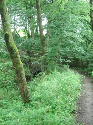
We pick our way up various bridleways, parts of The Burnley Way and The Pennine Bridleway, onto Deerplay Moor. I’m not saying it was all easy going, the farmyards were a mudbath but we got through. Views to our left are down towards the Cliviger Gorge where road and railway head for the delights of Todmorden. We come across a memorial stone to Mary Townley who was instrumental in establishing long-distance routes in the Pennines for horse riders. In 1986 she road from Hexham to Ashbourne to draw attention to the poor state of England’s bridleways. Today these improved bridleways probably benefit mountain bikers rather than those on horseback.

The quotation The air of heaven is that which blows between a horse’s ears.” is, in fact, an Arabian Proverb.

We had a bit of a depressing section on a road where there was evidence of fly-tipping every few hundred metres. I just cannot understand this blatant antisocial behaviour.

The ‘tree’ had been out of sight most of the walk but at last on Crown Point, we left the road on the well-trodden path across to it. Unfortunately, a Union Jack has been stuck into it diminishing the visual impact of the fine installation. There was only a light breeze today so the tubes were only murmuring. We speculated on what sounds were produced in the recent gales, there will probably be something on youtube. 

Crown Point is a fine viewpoint in itself with Burnley below and a backdrop of Pendle Hill. There had been some patches of old snow as we walked up and there was a definite white rim to Pendle Hill. Easy walking took us off the hill directly back to Walk Mill and its historical past,

*****


THE BURNLEY WAY. Day Five.

Portsmouth to Towneley Park.

If you google Burnley to Portsmouth by bus you can imagine the result –  a ten hour journey to the south coast. Today’s more modest journey went like clockwork, leave home 9.45, park up at Towneley Park, 10.43 bus to Burnley bus station, 10.55 bus to Portsmouth [the one in Cliveger Gorge] and I was walking back into Lancashire by 11.30. I’m becoming a bit of Burnley Bus nerd. The weather today was perfect for a change.  A track climbed steeply from the main Calderdale road and headed into the hills, unusually it was unmarked. Roe deer ran before me and disappeared in the bracken, only their barking could be heard. This was steep climbing and I was soon looking back down into Calderdale and up to distant Stoodley Pike.

Once above a remote barn conversion a smaller path made a beeline for Heald Moor.  A rough track then led along the ridge to Thieveley Pike which was marked by an Ordnance Survey Pillar, 449m,  the highest point on the BW. This was the essence of open Pennine walking just me, skylarks and cotton grass.

Halfway along the ridge was a stone marker plaque who’s origin I cannot find, any ideas?


The extensive views were back to the Coal Clough Windfarm, down Calderdale to Stoodley Pike and The Peak District, Lancashire Moors, Hameldon Hill, distant Bowland and then Pendle and the Three Peaks and more of Yorkshire…

  A subsidiary ridge went over Dean Scout Rocks  which made a convenient lunch stop looking down into the Cliviger Gorge. A steep track descended through more sections of the Burnley Forest. Going under the railway I joined a section of the Pennine Bridleway, this turned out to be a delightful peaceful pastoral passage past old farms on what must be an ancient track. Ripe raspberries in the hedgerows were a bonus.

I was circling a hillside plantation named the Fireman’s Hat though I couldn’t see the resemblance, this has been made even worse by a communication tower which has somehow been allowed to be placed in this prominent natural position, money must have changed hands. I walked my way through Walk Mill and payed a quick visit to the Barcroft Hall a 17th century building. Interestingly there was of those old American caravans in the garden.

I then entered the extensive grounds of Towneley Hall and met the masses enjoying a sunny day, children and dogs included. There are paths and avenues everywhere. An ice-cream van by the bridge over the Calder River was doing a good trade and I couldn’t resist a cornet. A stroll  past the hall itself, note to visit in future, and then up a mature lime avenue to the gates on the main road and my car.


So I’d completed The Burnley Way, in more days than planned and in poor summer weather conditions but had thoroughly enjoyed the experience. Met some lovely people along the way. Good varied walking with fascinating natural and industrial features in an area not known for its walking. My photos don’t do it justice. It is well waymarked and the guide leaflets from Burnley Council clear and accurate. I had learnt a lot more of this area and I highly recommend.


THE BURNLEY WAY. Day Four.

Worsthorne to Portsmouth.

Rain all morning, once again the summer weather had conspired against me but rather than be inactive I opted for another short stage. My lunchtime arrival in Worsthorne coincided with a brightening but showers were still in the air, however I didn’t need waterproofs for the rest of the day. A flagged path across a field took me into Hurstwood described as a delightful Elizabethan village with attractive buildings – most seemed to be under renovation at present so I didn’t dally. A lane crossed the infant River Brun which I had come across a couple of days ago in Burnley centre. The now cobbled lane passed isolated farmhouses onto the moor, I pondered on the man-hours  needed to construct these old highways. Dropping down into Shebden Valley the reason for the lane became apparent – an extensive area of quarrying. Apparently this was for limestone extraction using hushes and what remained was piles of unwanted stone, the sheddings. I joined The Pennine Bridleway at the bridge but for some reason I was directed to a smaller path into the workings, this soon became indistinct and my wanderings were more and more erratic until I hit the Long Causeway road.  [Stay on the bridleway!] This straight road possibly dates back to the Romans and was used as a packhorse trail in the 18th century. It is characterised now by the Coal Clough Windfarm which it runs alongside, I remember this as one of the first in this area. From up here Pendle dominated the skyline to the north.  At a corner a farm track continues on the original line and I just followed this although the footpath supposedly takes to the field. Another isolated farm is passed and a lovely little building which would make a good bothy but more likely an expensive holiday cottage.

The path traverses above a wild clough and passes through plantations which are part of The Forest of Burnley a lottery funded scheme to create new forest around the area, I had noticed secveral others on these walks. Pathfinding through the new plantations is not always easy and waymarking could have better. I found myself on the top of a gritstone cliff, Pudsey Crag according to the map, a diversion was taken to view it from the valley. It looked worthy of climbing but is apparently out of bounds on private land. Deep wooded cloughs are entered as one progresses towards the Cliviger Gorge, occasional cottages appear out of nowhere – this is a secret place. Coming out of one of the cloughs towards Brown Birks farm I was confronted by a large brown bull right on the track, I was so overawed I didn’t even get a picture. Backtracking I picked up another footpath circumnavigating the field and with a bit of ingenuity safely avoided the bovine obstacle. I was now dropping into Cliviger Gorge and looking at the climb out on the otherside which will start my next stage. Looking down were the back to back terraces of mill villages Cornholme and Portsmouth. I jumped on the bus to take my me back to Burnley but found it pulled off the main road to visit some smaller villages and I surprisingly saw I was only a mile from my start so I was dropped off and walked into Worsthorne. Another day of discovery.

THE BURNLEY WAY. Day Three.

Briercliffe to Worsthorne.

Another shortened day to accommodate the weather. I was back at Queens Mill and no sign of it opening to highlight Britain’s last remaining steam mill engine. Mill streets led to allotments and hen houses on the edge of town. The Parish Lengthsman pulled up and switched off his engine for a chat. He had been watering flower displays and was now off to do some path strimming. Throughout history lengthsmen have been employed to keep parishes tidy and the post has been revived in recent years to provide on the ground local maintenance.  We found we had mutual friends in Longridge and our chat covered many topics, he didn’t seem in a rush to get to work and I’m never in a rush when local knowledge can be gained.

Eventually I crossed several field to arrive at the grounds of Happa [Horses and Ponies Protection Association] and their modern cafe, as you know I won’t willingly walk past a cafe so I found myself inside enjoying a good Americano. Others were tackling mammoth portions of fish and chips, the cafe has a loyal local following. As you would expect horsey types were in strong evidence.

Skirting horse enclosures and then fields full of inquisitive cows I then began  descending towards the Thursden Valley but became a little entangled in boggy grounds and barbed wire fences – the way marking could be better. The valley itself is like a lost world with a small brown peaty brook meandering along. A path of sorts pushes through the sedges with occasional clumps of purple orchids and lots of meadow sweet. Horsetails seem to be trying to affect a takeover in some areas.

I came out onto a road with steep lanes leading into it – I recognised the situation from when we used to drive over to Widdop for a climbing session. The road leading out of the valley always appeared steep and exposed with a car seemingly wrecked down the slope to the left. I was amused to see its rusting form still there today.

A steady plod up the wild road and a descent brought me into Yorkshire with views down to Widdop Reservoir and the crags we so often climbed on. Prominent at the right-hand end was Purgatory Buttress, home of some classic extreme climbs. I was always attracted to the Artificial Route up the front and despite its scary moves was often drawn back to it. Below it are some beautiful boulders for a more relaxing if not taxing time.

Off the road a little track headed through the heather towards a stream where I found an ideal lunch spot. A Blackcap settled in the vegetation in front of me. A boggy section headed across the valley to join a distinct bridleway which climbed above Widdop Reservoir and onto open moorland close to Gorple and Hare Stones. More reservoirs came into view and Stoodley Pike was prominent across the Calder Valley. This track seemed very isolated today not another soul in sight and a rather broody sky.

…not another soul insight…

Distant Stoodley Pike.

A family of chirpy Wheatears were running on ahead of me. Burnley soon came back into view and you realise how close to the town this circular walk keeps returning. Down to my left Hurstwood Reservoir appeared where the route heads to but rain was in the air so I just continued straight down the bridleway into Worsthorne , with some interesting houses, for the bus, Hurstwood can wait till next time.

Hurstwood reservoir.

As I came down the track a mountain biker was heading up which reminded me of a ride I did with my teenage son many years ago on a long loop to Hebden Bridge and back. That was just at the beginning of the mountain bike revolution.


While on the subject earlier in the day I passed signs for a MB charity challenge, in a very good cause, from the previous weekend – why have those responsible not removed these by now. I consider these as litter once there purpose is over. Shouldn’t have ended the day on a sour note.

Name and shame.


THE BURNLEY WAY. Day Two.

Hapton to Briercliffe.

I must have been somewhat dazed when I left Hapton Station as within 15mins I was lost and heading back almost to where I started but once orientated I made a direct route into Padiham where I stumbled into an unexpected cafe [the Belly Buster] for coffee.

Anyhow after the coffee break my brain kicked into action and I was soon following the River Calder out of Padiham and into the Grove Lane Greenway. All peace and birdsong, it is difficult to imagine this area amongst the trees  hosted a coal colliery relatively recently . Across the fields was Burnley F.C. training ground and also Gawthorpe Hall. The latter is the end of The Bronte Way from Bradford which I hope to complete with Sir Hugh later in the year when he is fully recovered.

River Calder.

What looked on the map like a riverside path turned out to be a tarmacked lane so I made good progress. The day was overcast and warm, I seemed to be sweating profusely and not feeling good.  For no obvious reason I started to have a longing for chips. Were the two connected?

At a bridge across the Calder near an old ford, lots of sand-martins flying low, I met up with the said Bronte Way and also the Pendle Way [completed not without interest 20 years ago – another story involving the Mountain Rescue when I didn’t need rescuing.] Climbing steeply out of the valley the paths seemed to be little walked but the signing remained good and I kept on course. Mention of Pendle made me realise I had not seen this dominating hill today in the poor visibility but there across the valley it appeared out of the mist.

A series of horsey fields were traversed and suddenly I was looking down into the sprawling mass that is Burnley. Urban parks by the river led past a Holiday Inn, a holiday in Burnley? and down to join the towpath of the Leeds Liverpool Canal. This goes into the heart of Burnley and an area named the Weavers’ Triangle – a collection of 19th century mills and warehouses from when the town was a major cotton-weaving centre. There are ruined buildings and alongside renovated ones providing office and living spaces. Several weaving sheds were still visible with their distinctive sawtooth roofs giving Northern light. A covered wharf appeared and next to it a pub in a converted warehouse, The Inn on the Wharf. Despite the fact that I was carrying lunch the craving for chips got the better of me and I was soon sat with a pint of Copper Dragon, a salad sandwich and a portion of home made chips.

Burnley appears out of the murk.

Back on the canal after a couple of turns and more derelict wharves and mills you come to the ‘Straight mile’ where the canal runs along an embankment 60ft above the town. Easy walking with views to the new developments in town to the left and Turf Moor football stadium to the right. I am reminded of the former great days of Burnley FC with the outspoken Bob Lord at the helm, they won the league in 1960 – oh happy days. What struck me most about this stretch of the Leeds – Liverpool Canal was that there were no boats which is at odds with most stretches of our inland waterways. At the end of the embankment the canal crosses the river Brun [said to be the origin of Burnley’s name –  Brunlea]  A double back under the canal takes you into the Brun Valley Park a greenway leading out of town. A large part of this area was a former colliery though you wouldn’t know it today with all the mature trees in new parkland. Rather crudely carved wooden marker posts served this stretch of the Way bringing me out at Netherwood Bridge though there seemed a multitude of alternative tracks through the muddy woods. Hereabouts I took a more direct line up to the equestrian farm, busy with girls grooming horses and mucking out vast pile of manure. Further up the hill the Burnley way was rejoined for a stretch downhill into a hidden valley, orchids were plentiful on the damp meadows. At the bottom there was a little footbridge over the River Don, a stream really. What a lovely spot for a lazy Summer’s day – oh I had forgotten it is Summer.

A series of old stone flagged steps lead out of the valley, these steps go by the local name of Ogglty Cogglty whose meaning has been lost in time. At the top of the steep slippery ascent indistinct field paths go up towards Queen’s  Mill in Harle Syke. This large mill in a side street apparently is the last working steam powered mill but it all looked very closed to the public today.

To be continued…


THE BURNLEY WAY. Day One.


Towneley to Hapton.

I had chosen Towneley Hall as a convenient starting point for the 40mile Burnley Way which I’d broken down into three days’ walking. I’d obtained an excellent leaflet guide from Burnley Council which detailed the walk very well and it is marked on the 1:25,000 OS map OL21. I could see that a radial bus service would ease getting to and from daily start and finishing points, living so close it wasn’t worth paying for B and B.

A late start and a shortened day to let the morning’s rain abate. On the no 483 bus this morning was a man in full golfing regalia with trolley and bag so I knew we had arrived at Towneley Golf Club when he got off. I could have been anywhere but crossing the road I came across the first of the BW waymarks with the birds beak giving the direction up a little lane. I couldn’t make out the coke ovens which were supposed to be hereabouts but soon came across an art installation, part of the Wayside Arts Trail, a red brick kiln which is sadly falling apart or has been vandalised – a depressing thought. I realised I’d forgotten my camera so out came the phone.


Onto an affluent housing estate old tracks passed between properties, not the terraced housing one associates with Burnley, this is the west side of town.  Crossing a busy road I climbed up the hillside and was immediately looking down on the town and its moorland surroundings, this view was shared by the golfers I joined on an interesting looking course. I navigated my way between greens and across fairways without causing too much trouble and out onto the open fell. Up here apparently was the site of an Isolation Hospital serving smallpox and scarlet fever at the beginning of the 20th century and later TB patients, it was certainly isolated, how things have changed in a hundred years. Away to the left was the Singing Ringing Tree a well known sculpture I’ve visited on other occasions, its a shame it was not incorporated into the BW by following the Arts Trail. 

The Singing Ringing Tree from a previous visit.

Downhill in poor visibility towards Clowbridge Reservoir to cross another busy Pennine road linking the mill towns of the area, this one was heading to Rossendale I think. By the road were signs of previous mining activity with adits going into the hillside, this turned out to be the site of 19th century Wholaw Nook colliery. Four stones from the foundations have been carved by Ian Grant to represent Four Seasons in a Day, a reference to the local weather.


On the open moor track on the otherside of the road I met a couple from Bury who had been on the SW Coastal Path about the same time as myself so we swapped stories. They are hoping to backpack the BW in the near future. I found negotiating Nutshaw Farm a bit complicated with all the building work, I was not the only one as further on up a rough cart track was a delivery van with a puzzled driver trying to follow his satnav, I suggested he turned round while he could and sorted a route out for him on the good old fashioned 1:25,000 OS.

Approaching Nutshaw Farm.

A steady ascent above Clowbridge Reservoir and I was on Hambledon Hill, but not the trig point, with its various communication towers. Pendle Hill was visible to the north but south I couldn’t identify the moorlands. Even up here there was a burnt out car.

Looking back from Hameldon Hill over Clowbridge Reservoir to Thievely Pike.

Ahead was Great Hambledon but the BW doesn’t seem to bother with isolated summits, I was however drawn to a prominent cairn on the edge of the escarpment. This involved crossing boggy ground on a vague track with small stone quarries below me along the rim. The cairn gave me a chance to eat my sandwiches while watching the wind turbines to the east, these are always prominent from the A56 as you wind out of the Ribble Valley. Pendle was still misty and views into Bowland disappointing.

Towards Great Hambledon.


Murky Pendle above the Hapton Valley.

First of many windfarms.

Because I’d gone off route I had to find a way down the rocks which now encircled the moor and this proved tricky and time consuming. Once down there was a stretch of rough ground, an old firing range, an almost impregnable plantation and some irritating farm tracks. The plantation was one that had been developed with the help of lottery funding creating the Forest of Burnley project with many sites on the route. Then I was in Castle Clough Woods. I had been here before on The Hyndburn Way and was intrigued by the deep gorge apparently created by glacial meltwater. I was keen to explore further and left the BW once more and dropped into the gorge itself which has a small stream running down it. Heavily wooded steep slopes with quarried rocky outcrops must provide a diverse natural habitat – this is a hidden gem.

Deep in Castle Clough.

I managed to find a way out into Hapton playing fields and back to the station just as the weather was starting to improve.