Category Archives: Longridge

NORTHING 438. INSKIP TO LONGRIDGE.

January 27th.    7 miles.

This is long distance walking in easy stages designed for winter exercise. Todays stage actually finishes in Longridge, my home town, which is convenient for me if not for Sir Hugh who has to travel from Arnside, but it was his idea in the first place. At least today we meet up in the agreed destination, a good start. We are walking by 9.30 on a clear sunny morning with a strong cold wind at our heals. There must have been a lot of rain last night judging by the pools on the road – an ominous sign. We take to footpaths as soon as we can and end up in deep mud similar to where we left off last week. The stiles around Singletons Farm are virtually impassable, blocked by hawthorn, but we push through.Crossing a field we are confronted by the next stile leading into a lake, no way we can go that way so we retreat and hit the minor lane to Cuddy Hill [sounds Scottish] and the well-known Plough Inn. After all the frustrating obstacles I was ready for a drink but of course they hadn’t opened. Eventually we find the onward path and emerge onto a lane which took us over a canal. In the past we have both walked the The Black and White, Lancaster Canal.    but we didn’t recognise the location,

We were on the A6 for a short distance before crossing over onto tracks to end up in fields,  navigational errors had us back tracking to reach Jepps Lane. The A6 seemed like the transition from the flat floodplain of The Fylde to the pleasant countryside of the Ribble Valley. The wind by now had intensified and many of Sir Hugh’s pearls of wisdom were lost. I had never been down the lane to Barton Old Hall before, but it conveniently crossed the motorway for us. The Old Hall was hidden behind trees and the cluster of houses and conversions at the hall were rather depressing.

I think we were deterred from the actual path through the properties, but still found ourselves in rolling countryside alongside the proverbial babbling brooks. Time passed as we weaved our way through the pleasant Lancashire countryside. The Bowland Fells rose in the background and ahead was a glimpse of Longridge Fell.

We passed the stately Goosnargh Lodge, joined some local routes and reached Goosnargh Mill, not the best of conversions.

I was now on home ground and confidently marched across fields finding hidden stiles until we reached one that was in such a dangerous state we had to retreat yet again and find an alternative way. Worse was to come as what had been open fields was divided up by permanent electric fencing, the sort used for equine enclosures, with no regard for any public rights of way. Attempts at crawling under on the wet ground were not pleasant, so we took to dismantling the top wires to step over, there was fortunately no electric current. Reports to LCC  are on their way. A rather sour note towards the end of the day.

He who dares – SAS training.

Just before Longridge we passed Sea View cottages,  and yes you could just about see back to the coast where we had started SD 38.The road into Longridge is now surrounded on all sides by new housing developments, the Fell can just be glimpsed above the roofs. It is no longer the attractive, honest, little town that I moved to all those years ago.

*****

WINTER ARRIVES ON MY DAILY WALK.


The moon was still bright and large while I was having my reviving first coffee, always the best of the day.

Overnight an inch of snow had softly fallen and now in the morning sunshine all was glistening white, time for that short walk before going out for lunch. I try to put in a few miles most days even if it is only my  daily walk cum shopping trip.

Out past the white cricket pitch and up the lane with views to the Bowland Fells, rabbits had been out much sooner than I.

Fields take me onto the toe of Longridge Fell, around the icy reservoir road with views to Beacon Fell.

I arrive for a peep into Craig Y Longridge. Despite the snow the rock was in perfect condition in the sunshine and if I hadn’t other appointments I would have been tempted back later for some bouldering.

I was soon down through the town, a quick supermarket dash and home for a second coffee. Oh and the lunch at The White Bull in Gisburn was excellent, I think I had worked up an appetite.

*****

SKIPTON TO LONGRIDGE 2 – winter sunshine.

Barnoldswick to Chatburn.

Late sunshine under Pendle.

In Gisburn churchyard hidden in the long grass is the grave of Francis Duckworth, 1862 – 1941.  One of my recent diversions has been searching for significant gravestones with the help of a book by Elizabeth Ashworth – Lancashire Who Lies Beneath? and I’d recently found his. He is remembered as the composer of the hymn tune ‘Rimington’. Have a listen –

https://hymnary.org/hymn/SCM/56

We had found a bench in Stoppers Lane for lunch opposite the Rimington Memorial Institute and on a nearby row of cottages I noticed this plaque –


JD [now aka Doug} the Pieman and myself had started outside a Rolls Royce factory in Barnoldswick and wandered indirectly through the mill streets as close as possible to our Skipton to Longridge line. It was a perfect sunny winter’s morning.Until the 1974 local government reorganisation historic ‘Barlick’ was in West Yorkshire, as several of the other villages visited today. The rivalry/frienship between the two roses counties is continued today and highlighted on some benches in town. We spent the morning navigating fields and lanes past both old and renovated farmsteads, through the hamlet of Howgill and into the scattered Rimington village. We were in close proximity to streams which eventually become Swanside Beck that joins the Ribble near Sawley.

To the northeast were Ingleborough and Penyghent and to the northwest Longridge Fell, Beacon Fell and Fairsnape.

After lunch using back lanes we seemed to avoid one of Rimington’s famous features – Cosgrove’s fashion shop. We dropped down to Ings Beck and Downham Mill.Soon the Ings Beck Joined Swanside Beck and we were alongside the familiar packhorse bridge. The next bridge we were on was that high one crossing the A59…… from where there was our last view of distant Ingleborough before we stroll down into Chatburn before the sun sets.

*****

NORTHING 438. COAST TO COAST.

An email dropped into my box –

What about:
Longridge to the Sea – Eastwards.
Following the OS line 38. I have had a quick look and it appears more or less possible. Straight line 104 miles and interesting – certainly a lot of new territory for me.  Conrad. 
[Sir Hugh to those familiar with this blog]

I ignored this for a day or so, thinking it was too ambitious, and I had better things to do; like finish off the GR131 in the Canary Islands and complete my protracted Land’s End to John o’Groats. But the idea gnawed at the back of my mind, and I foolishly looked up the maps. The SD 38 Northing in question runs virtually past my house. It becomes the SE38 and the TA38 further east, thus is better described as 438 Northing. My mind was in action now, why not start on the west coast and finish on the east, 122 straight miles Blackpool to Aldbrough.

A bit of a pipe dream. Better do some gardening.

SKIPTON TO LONGRIDGE 1 – another straight line.

Skipton to Barnoldswick.Following on from the success of the straight line from Longridge to Arnside completed with Sir Hugh at the end of last year I have persuaded ‘the pieman‘ a resident of Skipton to undertake a similar scheme between our respective abodes.

The Pieman.

He is a lifelong friend, possibly blood related though I tend to ignore that, with whom I’ve shared many backpacking trips throughout Europe but recently we have not been able to meet up as much as required. So this was a good opportunity to get 2019 off on a better note. Thus I was drinking coffee in his house in Skipton early this morning before setting off on what could only be described as a drab day.

My local guide takes us across Aireville Park, where I used to play as a child, over the Leeds Liverpool Canal and out of town through an industrial estate with some interesting relics awaiting restoration.

Airedale Park.

We crept under a main road and crossed the placid River Aire on an old track into Carleton. This essential bridge for our route was just within the mile either side of our arbitrary straight line  The C19 mill in the village was originally for cotton-spinning but I remember buying carpets there in the 70s, apparently it is now luxury apartments.

Carleton.

Today we didn’t visit the village but took to unmarked footpaths through green drumlin fields. I have to concede that satellite tracking maps were a great help in navigating this section. We were going parallel to a disused railway [Skipton to Colne] and eventually we found ourselves walking along it for convenience until stopped by vegetation.Possibly we touched on a Roman Road leading to Elslack where there was a fort. Our priority was to find a picnic bench and there right in the middle of the hamlet was one in some sort of memorial garden. Having put his instant coffee powder into a cup he looked for the flask containing the hot water, unfortunately it was on the worktop back in Skipton. I had hot apple tea in my flask so he ended up with a strange brew.

We walked past the C15 Elsack Hall but at a discreet distance and then along the abandoned railway into Thornton-in-Craven joining the Pennine Way for a short stretch. The village has interesting old houses but no shop or pub and the heavy traffic deterred us from lingering.

Tree planted for the Coronation of Queen Elizabeth.

?Millenium Clock.

On the edge of the village are Almshouses built for poor women, there is not much of that charity evident today.

By the church a sign guided us to a Holy Well in the grounds, dating from Saxon times it is covered by an octagonal structure erected in 1764 by the rector.

On a short stretch of golf course we joined The Pendle Way. It weaved around a church and graveyard where every grave was decorated with flowers, presumably from Christmas.

Rolls Royce have a large presence in Barnoldswick and we passed one of their factories before joining the Leeds – Liverpool Canal for the final stretch into town. My overall impression today was of green fields and a rich historical background.

*****

AROUND LONGRIDGE TO SEE WHAT’S NEW.

I was drinking coffee and debating whether to go for a stroll or even rescue my bike from the garage for a ride when JD phoned suggesting a walk, we chose a short one circumnavigating the village as I was interested in the changes taking place. On reflection if we’d had more time we should have climbed onto the fells to take advantage of the perfect weather.

Anyone who knows Longridge will be aware of the rash of indiscriminate housing developments. These are immediately obvious from the road where for some reason the football club have sold off a field within their grounds, previously used for youth training, for six houses. Already this is creating problems on match days as now their parking is limited there is dangerous parking on both sides of the busy road and footways, time will tell.  Across the road the cricket pitch is being surrounded by development. I was surprised to see this strange buiding practice…

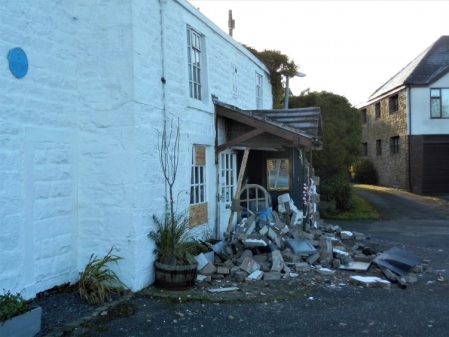
Climbing up through the estate onto Higher Road was an alteration of a different sort, the local Thai restaurant’s entrance porch has been destroyed by drunken drivers badly affecting trade over the Xmas period.

There were however peaceful views from up here over the Spade Mill Reservoirs. The little the bridleway past the reservoirs is popular with dog walkers and leads onto Alston Lane. Once across we followed a farm lane and found our way into fields with occasional waymarkers, so we only lost our way once heading down to a bridge across a beck. The next farm, Alston Lodge, was a mud bath.

The path weaves its way between the Alston Reservoirs, built for Preston as it increased rapidly in size. A large group of Canada Geese had descended looking for food. Alongside the last stretch of water a wetland reserve has been created and there are hides to observe the birds. Today we saw mainly Mallards!

At the end of Pinfold Lane onto the main road all is changing with a large housing development on its north side and unfortunately a long stretch of hedging has been unnecessarily removed. Fortunately our onward footpath bypasses the development, for how long?  Mardale playing fields give us a bench for refreshments before we cross the old railway line into Shay Lane industrial area. An old path follows a small stream where one used to hop across on stones but recently a wooden bridge has appeared.  Green Nook Lane is usualy quiet but at he end are more new houses on the left and then even more being built across the road and guess what – an Aldi has arrived.

Round the corner is Halfpenny Lane whose fields will all be built on before my next walk round our previously lovely little community. So a day where the negatives outweighed the positives I think.

*****

THE WAY OF THE CROW. Second day, Bleasdale to Arbour, Calder Valley.

JD seemed worried when I described the next leg of our straight line way – “it is extremely rough going, the game keepers are unfriendly and there are rumours of a wild rhinoceros”. Despite all that he agreed to join us on his recommended shortened version. The picture above was taken from his house when I picked him up in the morning, The Bleasdale Fells which we had to cross are to the left of the higher Fairsnape group. Beacon Fell is far left.

The car park at Bleasdale Church was busy with Sunday worshippers.

It was a glorious sunny morning as we used field paths into the heart of Bleasdale discussing our individual Saturday night’s exploits, I probably had the largest hangover, Sir Hugh had been consructing a cat flap and JD entertaing his family.

Donning extra layers when we realised how cold it was.

No that’s not the rhino but pretty scary anyhow.

After the isolated Hazelhurst Farm we found the beginnings of a land rover track that would, via a series of zigzags, take us steeply into the open access area and onto the fell top. We puffed our way up with frequent stops to admire the views over the nearby Fairsnape/Parlick fells with Bleasdale and  the Fylde below. Surprisingly and fortunately another quad track led to the remote trig point, 429m, of Hazelhutst Fell. We are on grouse shooting moors up here and much has been written about the persecution of other wildlife in this vicinity to try to promote the shooting fraternity. Whatever one’s opinions about grouse shooting I am strongly against the wilful and unlawful killing of our protected species. On this stretch of the walk we came across several loaded Fenn Traps which are legally only allowed for stoat trapping [killing] but are known to trap other species. These are lethal looking spring-loaded traps which could almost take the tip off your walking pole.

From the trig point there were hazy views across Morecambe Bay to Black Combe and Barrow. Taking a compass bearing we set off across the heather in a NNW direction and fortunately found another quad bike track taking us down past shooting butts so avoiding all the heavy going. After what I’ve said about the grouse shooting land owners we were thankful for their tracks. The final descent was vertiginous. The surroundings were reminiscent of a Scottish Glen and we found the bridge over the Calder to the Victorian shooting cabin of Arbour. This must be one of the best kept secrets of Lancashire.

We found a sheltered spot out of the cold east wind for lunch. There were no windows into the shooting lodge to see the rhinoceros head. The story goes that a rhino escaped from a train near Garstang and had to be shot, it’s trophy head being mounted in the lodge.

By now all the excitement was over and we had an easy walk out on the track alongside the River Calder.  We were back at Sir Hugh’s car much sooner than we’d planned because of those good moorland tracks. We will have to walk back in next time to rejoin our line.

*****


THE WAY OF THE CROW. First day, Longridge to Bleasdale.

I was apprehensive, walking in a straight line as possible would take us on unfrequented paths, would the way be feasible. We left the village down overgrown Gypsy Lane and shortly after found a gate secured by a cord, a veritable Gordian Knot. Out came Sir Hugh’s, I’ll blame him, Swiss Army Knife and we were through.

‘Gypsy Lane’

We passed the ponds, ‘figure of eight’ where my children used to go fishing without much success but I’m sure they had an adventure away from parental supervision – they never drowned so I must have been doing something right.

The next farm-yard, where I’d previously climbed walls to escape, was now well signed and we even had a resident directing us to the hidden stile ahead though the accompanying foot plank, couldn’t call it a bridge, didn’t inspire confidence.

The slippery plank.

We reached a farm gate on a public footpath which was securely padlocked, no Swiss Army knife could cope, but as if on cue a lady drove up in her battered pick-up and opened up for us. Remonstrating about obstructed footpaths didn’t seem to be appropriate. All was pleasant rural scenery with scattered farms, some in better condition than others.

The next problem was of our creation, contentedly walking along the tiny River Loud we were almost in someone’s back garden when we realised we’d missed our path but fortunately a gate allowed our escape onto the road.

The infant Loud.

Things improved as we headed closer towards the Bowland Hills and Bleasdale. We passed the small rural Bleasdale School and headed for the church where our car was parked. We were last here in gale force Ali. A group of fell runners were just setting off for a quick few miles and we exchanged pleasantries. Walkers, climbers , cyclists, runners tend to have a common background.

Is that an Ofsted verdict?

We had completed the first leg of our project with very little deviation from the straight and narrow and to be honest no serious obstacles except a lot of slippery stiles. Our way ahead over Hazelhurst Fell could be seen, the fell runner is pointing the way, but will there be any paths?

Yet another slippery stile.

***** 

THE WAY OF THE CROW. LONGRIDGE TO ARNSIDE.

My good friend Sir Hugh  [http://conradwalks.blogspot.com/ ] inhabits that lovely village Arnside whereas I have to put up with the gross overdevelopment of Longridge. For the last few winters we have had projects to keep us active in the shorter days. He has emailed once or twice with suggestions for this year but nothing has struck me as original, boringly I seem to have walked most of the Long Distance Paths in the NW. I came up with a counter suggestion – why don’t we draw a straight line between our houses and follow it as closely as possible. I know this idea has been used before, particularly successfully  by Nic Crane on his straight line Two Degrees West journey from Berwick-on-Tweed to The Isle of Purbeck. I seem to remember he gave himself  a kilometre leeway either side but had a lot of media support, I wonder if we could be even stricter. True to form Sir High has taken the bait and the line has been drawn.

It is the wrong time of year for backpacking so we will split the route into day walks. The distance as the crow flies is 26.5 miles but we will be lucky to keep it under 35 miles. No rules except keeping as close to the line as possible preferably on footpaths or quiet lanes, legal ground or not. There are some obvious obstacles in the way – the fells of Bleasdale, the Rivers Wyre and Lune, Quernmore Hall Estate and the M6. It will be a challenge overcoming them, lets get started.

ALSTON – LOOPING THE LOOP.

As the crow flies it is 4 miles from Longridge to Samlesbury, where BAE Systems [previously British Aerospace] is based, however the River Ribble is only bridged at Ribchester or Preston both giving a far longer journey. A friend of mine would in summer take a short cut down Alston Lane and ford the river with his bike straight to work. Today I tried to identify the place he crossed but of course there was a lot of water running, I think the above photo is roughly the spot and I shall investigate further next summer.

Anyhow back to the beginning. Lethargy and other pressing problems these last few days have kept me in; it is easy to slip into this mood when the clocks change and Winter approaches, that is the reason I normally go off to sunnier climes. I planned this route last night and set the alarm so I was committed to venture forth. There was a window in the weather so timing was crucial which still gave me a leisurely breakfast. I was parked up at 10am,  My clockwise circuit ment walking on the main road for a few hundred metres alongside the ghastly development of new houses, all dumper trucks and lorries. Why have they seen fit to obliterate over a 100m of hedging to gain access to the fields? This did not put me in a good mood.

Thankfully I soon turned down Pinfold Lane  [pinfold – a pound for stray animals] and looked into the adjacent field where I found the base of the ancient Bolton Fold Cross which I’d not noticed before.

There were a couple with binoculars in the hides overlooking the wetlands adjoining the lane. I couldn’t see anything of interest except a long view to St. Lawrence’s Church and the prominent Dog Inn in Longridge.

Over towards Pendle there were darker clouds contrasting with the sunlit autumn foliage. Lanes linked little farms, most now converted into modern residences. A lot has changed since I last came this way. I bumped into the father of climbing brothers from the past and we chatted about old times. A farmer further on was more expressive [forthright as only farmers can be] about the world’s problems. All in a day’s walk. Hereabouts The Ribble Way crossed my path heading towards Ribchester on the line of a Roman road, of which there is little evidence.

Not all has been beautified.


This guy means business.

Dropping down fields I seemed to be heading to a cul-de-sac but there in the corner was a stile and a footbridge over the stream, all very delightful.


“falling leaves hide the path so quietly”
John Bailey

At last the object of my walk, the River Ribble, was glimpsed through the trees below. The river here makes a looping curve around flat fields with an escarpment on the south side. Ducks were floating in groups and when disturbed fired off in all directions like some of this weeks explosives. I do not understand why the Ribble Way doesn’t follow this delightful stretch of rural Lancashire.

Once past the ‘ford’ I was looking for C17th Old Alston Hall but only had a glimpse of it across private gardens. Higher up the lane is the C19th gothic Alston Hall which was used as an education centre by Lanc’s County Council until being sold to a private buyer. I won’t add fuel to the rumours of its recent extensive fire and plans for redevelopment. The observatory run by the University seems unaffected.

Old Alston Hall.

New Alston Hall and observatories.

It was a relaxing walk up Alston Lane, noticing all the recent residential conversions, back to my car. As I reached it the rain started in earnest – it’s all about timing.

*****

Possible ford in red.


‘BOWLANDCLIMBER’ – WHAT CLIMBER?

A little inspiration.

Anyone who has been following my posts this year or anyone searching ‘climbing’ will have noticed there has been no climbing. For various reasons I haven’t done a route for the first time in 40 – 50 years.* My climbing friends probably think I’ve died. This was brought home to me the other day when I happened to be in south Preston with one of my now ‘retired’ climbing partners.

“I think we are near Denham Quarry” I mentioned,  “let’s go and have a look in”

Easier said than done as we drove arround in a maze of forgotten narrow lanes and kept crossing and recrossing the motorway. All of a sudden Holt Lane appeared and the name rang a bell, sure enough a short distance down the lane the familiar car park appeared and there was the quarry.

And there was that striking clean quarry face with the obvious groove line of ‘Mohammed’

In we went and peered up the classic groove which had a few chalk marks on it. When did we last climb this – one for the history books. Its real title is, wait for it, Mohammed the Mad Monk of Moorside Home for Mental Misfits. What’s that all about?

My friend is suffering a cruel form of dementia and has lost her speech but on seeing Mohammed excitedly started making climbing movements with her arms. A wonderful moment.

Moving right under the main face other routes were recalled, most of them scary on small holds and poor gear. We had survived.

And there was that deep pool, with unknown monsters in its depths, and the lovely soloable Splash Arete above it. Memories.

Back home I reflected that I probably would be struggling on those routes now but my enthusiasm was fired and on a sunny afternoon I’m up at Craig y Longridge traversing around on familiar territory at the easy far end. The crag is bathed in warm sunshine and I’m the only one here so I can laze around as much as possible. I can do the moves but my hands have become soft and soon my skin is protesting, enough.

* PS. The following morning I had a brief visit up to Kemple End and soloed a couple of short routes to break the year’s zero statistics.


HEDGEROW FRUITS.

After the rigours of last week’s walk in the gales I’ve returned to my usual stroll around Longridge.

I was very aware of the fruits in the hedges as I walked up the lane to the farm. The best of the blackberries have gone but I started to count others and wondered about their edibility and uses.

Hawthorn.  [Cretaegus monogyna]                                                                                  

Very prominent were the red berries of the Hawthorn bushes. Apparently the berries contain potent antioxidants and have been used in herbal remedies for heart problems. Leaving that aside I have found some recipes for jelly and tea, but I’m not convinced as yet.


Rose Hips.                                                                                                                                                                                                           

Scrambling through the hedges were rose bushes with their characteristic red hips at this time of year. Now I know these do make a good jelly and also tea. The itchy seeds need to be removed first and apparently they are best after the first frost.


Rowan, Mountain Ash. [Sorbus aucuparia]

                                                                  
I’ve never before considered whether Rowan berries were edible but reading up about them shows they are, again mainly in jellies or jams.


Elder. [Sambucus nigra]

In past years I’ve made elderflower cordial but not used the berries. They can me used for wine making and also in pies and crumbles.


Blackthorn Sloes. [Prunus spinosa]

This year seems to have been good for the sloes on the blackthorn which grow commonly round here. I think their main use is for flavouring gin and other spirits.

So a short walk brought several possibilities of hedgerow fare, I will research a few recipes in more detail and return for some Autumnal pickings.

MY DAILY WALK, [well almost daily].

The weather has not been good since my return from France, I feel Autumn is upon us.

It’s noticeable how often I comment on the state of the weather at the start of a post. Is that a British trait, am I obsessed with the climate or does it just reflect the close connection of conditions with my pastimes?  I remember when I was younger and outdoor time at a weekend was precious we would sally forth on walks or climbs whatever the weather. That would result in a fair share of days with no views and a good soaking on the hill or gripping climbs on cold slippery wet rock. Many of those occasions are vivid in my memory, proof of the importance to me of outdoor adventures and the companionships they bring. Character building was a phrase used. Now I take more heed of the forecast and try to choose the better days for my enjoyment or more likely head abroad to avoid the worst of our winter weather.

I’ve rambled off the subject.  I intend, now I’m free of the PMR stiffness, to  do a regular local walk most days to build up my fitness once again. How often have I said that? I have a 4mile circuit on my doorstep that suffices. Not only does one get some healthy exercise but also some physic benefits thrown in.  There are countless literary quotations extolling the virtues of walking, one of the simplest  –  “I have two doctors: my left leg and my right leg.”  G M Trevelyan.

I complain a lot, and will continue to do so, about the housing developments in Longridge destroying the character of the town but I’m still able to do this walk from my house into the country. Why drive anywhere in mixed weather when a walk can be accomplished from home.   A stroll down the road takes me past the cricket ground where today there was a match which I can stand and watch for a few overs. There’s something special about village cricket which makes it almost hypnotic to engage in, I think it is something to do with the enthusiasm of the players and the gentle clapping of the handful of spectators. Long may it be so. The lane I usually take up onto the fell gives a lovely view back across Chipping Vale to the Bowland Hills. The view is different with the seasons but gives a sense of space and nature within half a mile of leaving home. Today this was heightened by a pair of Buzzards wheeling and mewing above me. Time just goes by whilst you stand and watch. A glance over the reservoir at any other bird life – usually ducks and grebe. And a glance into Craig Y Longridge to see if anyone I know is climbing, not today with the damp conditions. My return down the town’s main street is more mundane but gives the opportunity for social engagement and grocery shopping.

A perfect little circuit, I’m off to do it again today when things will be different.

*****


THAT SHORT WALK OUT OF LONGRIDGE – UPDATE.

I was thwarted a few weeks ago on one of my regular local walks by a completely obstructed path.

Well today I followed the same route to see if anything had improved.

I’m not sure if the local authority or the farmer have got round to doing anything but I’m pleased to find the way open. I suspect some local walker/activist, I know a few, has cleared the way – well done. I think that in future with financial constraints placed on local authorities and the ever increasing pressure put on rural societies that we will all have to take things into our own hands to preserve the footpath network.


I continued on my way back to Longridge on unobstructed and for the most part signed rights of way.

*****

A SHORT WALK OUT OF LONGRIDGE.

I set off in the cool of the morning to walk a circuit of fields and lanes which is on my list of regular local outings. I was looking forward to a 5 mile walk with an emphasis on photographing the current flora. A footpath sign points off the road down a green track which opens into fields. A plainly waymarked stile crosses into the next field and I happily wandered on to where it goes through a hedge by a pond. Today however I could go no further as a new fence topped with barbed wire blocked the way and it was insurmountable, even for me.  I checked either side to see if the stile had been moved but no there was no access on this Public Right of Way. I had no option but to turn around and head home in not the best of moods.How can a landowner just completely ignore a well used Public Right of Way? There should be much harsher penalties for this brazen obstruction. I will not let them get away with it.

Lancashire County Council have an excellent on-line reporting service for problems with Right of Ways, you identify the position in question on a map and click. You are then given chance to describe the problem and hey-presto it is reported with an identifying number. Of course that is only the start and one has to hope the council take the matter up with the landowners.

http://www.lancashire.gov.uk/roads-parking-and-travel/fault-reporting?coords=,&type=default

I wonder if the obstruction miraculously disappears in the next day or two?

*****

BLUE PLAQUES IN LONGRIDGE.

How to make the best of a sunny afternoon whilst I’m not able to climb the fells?

I have had in mind for some time a walk around my home town of Longridge visiting the buildings bestowed with a blue plaque. A quick piece of research of Longridge Heritage Committee information told me they had placed 15 in total – so off I went, camera in hand.

I intend to let the plaques give you the history whilst they are legible …

No 1. CRAMPOAKS MILL.

At the bottom of the main street, Berry Lane, is Booths Supermarket. From the front it could be any retail outlet but viewed from the side the telltale ‘saw tooth’ north-facing roof lights marks it out as an old mill, there were many such cotton mills in Longridge, spinning and weaving.           

No 2. Youth centre.

Across the road on the corner is an undistinguished building housing a community and youth centre with several notable past uses including the Bond Minicar developed in town.

No 3. The Towneley Arms.

A popular local pub situated next to the old station. An adjacent level crossing was used on Berry Lane where the line crossed to sidings for the mills and on its way up to the quarries.

No 4. The Old Station.

The station has been sympathetically restored as a Heritage Facility and a popular central cafe utilising the platform space as well as the station building. There is always a wealth of local information available in the heritage centre. Searches on the internet will soon provide more history on the Preston – Longridge railway and its unique branch to Whittingham Hospital which in its heyday was one of the largest Mental Institutions in Europe.

No 5. The Co-operative Building.

On the next block up is another imposing stone building previously holding our co-op. When I first arrived in town I would shop in the various departments of the large store. The plaque mentions the ballroom upstairs but I mainly remember the Polash Indian Restaurant up the stairs when the space had been divided – good old Ronnie was an excellent chef and I still have contact with his family in Burnley. The present co-op store has moved to a new building next door and the lower floor shops are now charity and betting – a sign of the times. The rest of the building is however used as semi affordable flats. Shame they didn’t restore the clock which is visible from most of the lane.

No 6.  Methodist Church.

This Wesleyan Methodist Chapel is now in private ownership having been sold off and the congregation incorporated into the United Reform Church down the road – now the thriving Christ Church. Needs must. I have never been inside it.

No 7. The Stone Quarries.

I hit a problem here – I couldn’t find the blue plaque! I presumed it was by the tunnel linking the railway to the quarries. In the past the railway line continued from the town centre through what is now John Smith’s Park and connected with a horse drawn incline up into the extensive quarries, Tootle Heights, producing high quality stone for many construction projects in the NW. Liverpool and Preston docks and many public buildings in Preston. The raison d’ètre of the line.

Tootle Heights Quarry in its heyday.

No 8. The Quarryman’s Arms,

Just below the quarries is this old pub building – now my favourite Thai restaurant.

No 9.  Club Row.

Walking back down Higher Road you come to a row of cottages on the left. They have an interesting history.

No 10. Cinema.

Unfortunately the cinema is under scaffolding at present, undergoing refurbishment with new owners who hope to continue operating it as private cinema. It has been a unique experience with ice cream usherettes, tea and coffee in mugs and the National Anthem, lets hope it continues to be.

Its noticeable how many properties in the old parts of town were previously involved with  hand-looming.

No 11.  Fell End.

Continuing down the hill there is an old building, now a funeral parlour, on the corner bearing the plaque. The Duke William pub opposite is now private housing.

No 12. St. Lawrence’s Church.

Opposite across the main road is the parish church in a prominent position approaching the town.

No 13. New Town.

Round the corner on the busy Preston Road is an area known as New Town which is now a conservation area. The water pump has been restored. As a bonus here we get a Red plaque.

As it was…

No 14.  Stone Bridge.

The busy roundabout at the end of Preston Rd is built on Stone Bridge where the railway entered town. Not the most salubrious environment – don’t hang around.

No 15.  St. Wilfred’s Church.

The prominent church further along Derby Rd is Roman Catholic, an important religion in the town.

So a walk of about 3 miles has included all the plaques but there are so many more interesting stone buildings in town that I feel I could produce another circuit.

WALKING OFF SAD – NEEDS MUST.

Introduction…
Seasonal affective disorder (SAD) is a type of depression that comes and goes in a seasonal pattern.
SAD is sometimes known as “winter depression” because the symptoms are more apparent and tend to be more severe during the winter. The symptoms often begin in the autumn as the days start getting shorter. They’re typically most severe during December, January and February.

Symptoms of SAD can include:

  • a loss of pleasure or interest in normal everyday activities
  • irritability
  • a persistent low mood
  • feelings of despair, guilt and worthlessness
  • feeling lethargic (lacking in energy) and sleepy during the day
  • sleeping for longer than normal and finding it hard to get up in the morning
  • craving carbohydrates and gaining weight.
The exact cause of SAD isn’t fully understood, but it’s often linked to reduced exposure to sunlight during the shorter autumn and winter days. The main theory is that a lack of sunlight might stop a part of the brain called the hypothalamus working properly, which may affect the:
  • production of melatonin – melatonin is a hormone that makes you feel sleepy; in people with SAD, the body may produce it in higher than normal levels
  • production of serotonin – serotonin is a hormone that affects your mood, appetite and sleep; a lack of sunlight may lead to lower serotonin levels, which is linked to feelings of depression
  • body’s internal clock (circadian rhythm) – your body uses sunlight to time various important functions, such as when you wake up, so lower light levels during the winter may disrupt your body clock and lead to symptoms of SAD.                                                                                             
  •   Treatments for SAD

  • lifestyle measures – including getting as much natural sunlight as possible, exercising regularly and managing your stress levels
  • light therapy – where a special lamp called a light box is used to simulate exposure to sunlight
  • talking therapies – such as therapy.
  • antidepressant medication.
      from  nhs.uk


Why am I telling you all this – well most winters I disappear to sunnier climes as I’ve found over the years that it prevents all of the above. As well as the improved climate I am usually involved in some semi-challenging walk giving me loads of exercise. This year I’ve been grounded because of my hip problems brought on by excessive exercise. Recent posts will have shown how I’ve partially dealt with it, sorry for the maudlin tone to those. Why don’t I just go abroad for a couple of weeks you say – well I’m not good at ‘lazy’ holidays by the pool, would probably just eat and drink too much.

Thus I’m still battling on, physio next week. So when the sun shone this morning I needed to get out. Luckily JD, of GR131 fame, phoned and within 30 mins I was at his house with a plan to do a relatively easy walk to Ribchester and catch the bus back. Off we went with bus passes at the ready.

The watery sun shone, as planned, whilst we walked past the extensive Longridge reservoirs.

The stroll down the quiet Hothersall Lane was a pleasure, as it warmed up I could feel all that lovely Serotonin fighting off the nasty Melatonin. The usual  juxtaposition of irreverent [me] and intellectual conversation [JD] bowled us along and soon we were dropping down the steep escarpment to Hothersall Lodge an outdoor centre run by Lancs County Council. Nobody was about but signs of activity were everywhere, climbing wall, zip wire, grounded canoes, archery ranges, nature walks etc. A great place to introduce people to the outdoors. We were now following the Ribble Way, a flawed route due to private fishing interests unnecessarily diverting the path higher up stream.

Further on was Hothersall Hall, a Gothic style building refurbished and providing privileged accommodation to some persons.  I tried in vain to relocate the Hothersall Boggart – a slightly grotesque stone head in the fork of a tree with associated legends. No luck today but I know its there somewhere.

All was going well with the walking until now, a good surface and fairly flat going. I had forgotten the little hill to be crossed on muddy fields – it was not a pretty sight as I struggled to cope with the terrain. Thankfully I’d brought my tracking poles, not to be separated from them these days. There were good views down to the River Ribble.

That hill!.


We had time to look across the Ribble to the extensive Osbaldeston Hall on the south bank. A path led off towards it and presumably some ancient ford crossing. JD remembered wading the river here on some previous walk but not today thank you.After that it was a stroll to walk into Ribchester, were we on a Roman Road?

Eschewing the Roman artifacts and other attractions of the village we headed past the now closed White Bull with its ‘Roman columns’ to the friendly Black Bull where we enjoyed a quick slurp of Bowland Brewery’s Buster before catching the rattly bus to Longridge.

Needs must so SAD can SOD off.  I’ve plans for the next week or so if the weather is good.


LAST WALK OF 2017.

After my last post I feel I need to end the year on a more positive note. Today was sunny and dry, ideal for a hill walk but I’m still confined to flat roads. I had a plan to visit some wetlands created by United Utilities [if that is their most recent moniker] on the outskirts of Longridge. Threading my way through streets, alleys and lanes I came to the observation hides overlooking the site. I had the foresight to bring binoculars [but not a camera] – there were lots of ducks, geese and lapwings visible but nothing more. The lapwings were en-mass and looking in prime condition feeding on the marsh.  So despite the doom and gloom of yesterday’s post on Longridge being swamped with housing developments here we have some more environmental positivity.  Sadly the majority of the local population are probably ignorant of this scheme.

I will return again in 2018.

Oh! to be on those hills.

*****

THE GREEN FIELDS OF LONGRIDGE.

You may remember if you live locally a post of mine from  2014. So long ago?

Well the fears have become fact. The planners have failed us and the developers have destroyed us. That outline development map has become reality.

A walk around the outskirts of Longridge this week produced these pictures of ‘rural idyll’

As the cars queue up outside my house in this evening’s rush hour I have no further comment.


                                       HAPPY NEW YEAR!


THE GARDEN IN DECEMBER.

Well I made it through the year with my garden diary.

Today is the winter solstice, seven hours and 49 minutes of daylight if you are lucky. Its pretty grim here today in Lancashire with drizzle and mist. I missed the classic photo of the robin in the snow last week. Not much else to show in the garden at the moment.

Picea koraiensis

Helleborus foetidus

HAVE A GREAT XMAS AND A HAPPY NEW YEAR.