Category Archives: Longridge

THE GARDEN IN FEBRUARY.

I must say that it was a slow start to the month with cold weather holding things up, only by the middle of the month did the temperature reach double figures and then came the wind. Even this morning we had a light snow shower. Normally I’m walking or climbing abroad this month but due to procrastinating I’m still suffering the British weather – I have however make good progress with pruning and shredding, neglected lately, so a large area of the borders now has a decent mulch. Accompanying me has been the sound of birdsong – it becomes louder as the month progresses, reminding me to provide some more nesting boxes.  All around in Longridge the fields are being eaten up with new developments, now that planning control has become meaningless, so I’m glad I have my own bit of countryside no matter how small.

The usual bulbs have pushed through and started flowering – snowdrops, crocuses, narcissi, scilla and anemone blanda – Featured ImageA few early herbaceous plants are flowering – a primula variety,   bergenia and pulmonaria officinalis. 
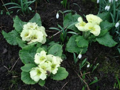
I have a young prunus ‘Autumnalis Rosea’ which struggles to show a few blossoms, I hope it will improve with age.This exercise of showing a month by month diary of my garden is beneficial in that it is highlighting gaps which I hope to fill. I notice my yellow witch hazel [Hamamelis] has disappeared and needs replacing. Within the last couple of days my pieris japonicas are just coming into flower – the aptly named ‘lily-of-the-valley shrub’.What will March have to offer?

THE GARDEN IN JANUARY.

I have been meaning to follow my garden through the seasons for awhile – January is a good place to start. Due to our topsy-turvy climate this year there are no pretty pictures of fragile blossoms pushing through the snow, though a spell of icy weather has retarded some plants. 

The photo above shows a rather bare garden with my progress in cutting down a 50year old Blue Spruce that lost all its needles a couple of years ago and unfortunately shows no sign of recovery. The best wood will fuel my stove but I’ve decided to shred the brash to use as garden mulch.

January is a difficult month for flowers and I’ve relied on hardy shrubs to bulk up this post. From the start of the year the Mahonia, Jasmine and Virburnum have been in constant bloom. Slowly the Hellebores have come into flower and that’s about it really but I’m hoping things will get going next month. Maybe I should plan ahead for next January with more plantings.

Mahonia Charity

Mahonia Charity

Jasmin nudiflorum.

Jasmin nudiflorum.


Viburnum Bodnatense

Viburnum Bodnantense.   

Helleborus argutifolius. Corsican Hellebore.

Helleborus argutifolius. Corsican Hellebore.

Helleborus sternii

Helleborus sternii

Helleborus purpurascens.

Helleborus purpurascens.                                                     

Helleborus niger.

Helleborus niger, Christmas Rose.

I’ve just come in from the garden as the sun sets and starlings congregate in a nearby tree for possibly some murmuration later.

A sparse but busy week.

After all the walking activity of the last few weeks things have slowed down, in fact stopped. For many reasons – visiting dentist and optician, purchasing new washing machine, boiler and car, catching up with family and introducing a new rescued cat to my household [phew] I don’t seem to have ventured far. But things are changing, there has been less rain and some sunny days, boulderers are venturing onto Craig y Longridge, joggers and cyclists are everywhere and the sunsets from my garden show promise of better things to come.

A Local Weekend.

Writing this whilst outside is a torrential downpour and distant thunder. The strange summer weather continues. This weekend I’ve managed two contrasting walks.

Saturday. A dull morning but things improved after lunch so I took the opportunity to complete a few more map squares I had signed up to for in the Ramblers ‘Big pathwatch’.

The idea is that every public footpath in England and Wales, all 140,000 miles, should be walked and any problems noted and hopefully duly sorted. I like to do my bit for the local paths around Longridge. No big problems found today – only one electric fence with no safe way through. However it is the height of summer and the height of vegetation is noticeable on lesser walked paths, you certainly need long trousers. So by the end of the walk I had had enough of nettles and brambles, and the Ramblers can’t do anything about that.


Sunday. After yesterday’s field path navigations I felt the need to be free up on the fells. The morning was warm and sunny with the threat of storms later so I was away relatively early to park above Chipping for my usual Saddle Fell, Fairsnape and Parlick circuit. The path goes through the yard of Saddle Fell Farm and steeply up an old peat collectors track. Several WD numbered marker stones are passed – a reminder that these fells were once a tank and firing range back in the 40’s. Saddle Fell also has a tragic past – on a sunny  Sunday, 25th March 1962, three teenagers, two brothers [11 and 18] and their sister [15] set off from Chipping for a walk over to Langden Valley. The weather changed with low cloud and a snow storm moving in, they soon became disorientated and hypothermic. Somewhere on Saddle Fell the boys sort shelter in some rocks but the girl staggered on to raise the alarm at the farm. Both boys were dead when found the next day and this led directly to the establishment of a mountain rescue team in this area. As I climb the fell I pass an old stone shelter and often wonder if this was the site of the brothers last night.There was a very strong Easterly wind and I virtually ran along the ridge. With some local knowledge this route can be achieved without any serious bog trotting. The air was warm and the haze hid any distant views but you do experience a strong sense of wilderness and space up here. Today I was really only interested in putting some miles below my mountain boots and a quick 1000ft of climbing as part of getting a bit fitter for a forthcoming trip in the Austrian Alps. A few pairs of grouse startled me as they flew out of the heather, so they haven’t all been shot since the ‘glorious‘ 12th. Strangely for such a sunny morning there was virtually nobody on the fells and the wind was too strong for the parapenters and gliders. Although I did witness the strange sight of a group carrying the model planes up to fly – it looked as though they were carrying crosses up to Calvary.

I was back at the car in under two hours and will return for some more training with a heavy rucksack next time.

A HAPPY BOWLAND NEW YEAR.

Since arriving back from La Gomera Christmas has come and gone, I’ve reacclimatised to the weather, caught up with family and friends, been walking and [indoor]climbing and now 2015 is upon us. So Happy New Year and here are a few random photos in the Bowland locality from this last week of mixed weather.

Langden Brook.

Pikefield Plantation, Slaidburn.

Hazelhurst Fell across Bleasdale.

Gliding past Parlick.

My boys under Fairsnape.

Fairsnape and Parlick.

Parapenting out of the mist.

Parapenting out of the mist.

Ascending Saddle Fell.

Ascending Saddle Fell.

Light into Chipping Vale.

Light into Chipping Vale.

Not me!

Not me!

Parlick in evening sun.

Parlick in evening sun.

What hope for Longridge in 2015?

What hope for Longridge in 2015?


WRITTEN IN STONE.

A short Longridge walk.

The glorious  day is disappearing under a pile of  ‘to do things’ – tax return, xmas cards, e-mails etc. So after lunch I draw the line and decide to get out. I’ve, like many of you, a library  of guide books, some international, some national but many local. Looking for inspiration I delve into a  local one and come upon a walk passing by ‘The Written Stone’ on Longridge Fell.  Somewhere I’ve not visited for years, perfect for this short afternoon.

Having no need for the car I walk up Mile Lane [though it’s less than 1/2 mile!] …

Looking back down Mile Lane.

… over the tail of Longridge Fell, past Craig Y Longridge and onto bridle ways leading to Written Stone Lane in Dilworth.Here near the eponymous farm in a curve of the lane is The Written Stone. An eight foot by two foot by one foot stone set into a wall and inscribed thus – Ralffe Radcliffe laid this stone to lye for ever AD 1655

Many legends and myths surround this stone, woe betide anyone who tries to move it. Tales of ghosts and boggarts abound….

The Written Stone of Dilworth

Safely on my way I pass the CORPORATION ARMS pub, formerly the BLACK BULL INN, built in the 1700s. It was bought by Preston Corporation Waterworks and renamed in about 1865. It is reputed to be the only pub in the country to be owned by a waterworks!

As I return home via the village shops the ice on the shady walls has not yet melted. Spooky.

LONGRIDGE TOWN “PLANNING”

  • LONGRIDGE.    “8000 friendly people, wonderful countryside and a great social life!  What else do you need?” — a quote taken from their own website. That at present is quite true, but there is trouble afoot. Due to a lack of forward local planning, developers are highlighting areas of land around our villages to appease the Government’s hypothetical and unrealistic targets for housing needs in the next decade. The map above shows the problem with up to 2500 houses projected [in red]. Roads, Schools, Doctors, Sewers — where are those plans? There is a genuine feeling of anger in the village over the proposals, but the councils seem unable to call a halt to these Developers’ speculative plans.     

To celebrate the millennium, Ribble Valley produced leaflets and waymarked six excellent walks in and around Longridge exploring the diverse landscape and heritage. [Available from our thriving local library] One of these is a 6-mile circular tramp around the village making use of tracks through the surrounding green spaces, these are the very same spaces that are now highlighted in red in the above plan. So today I thought it was an opportunity to repeat and enjoy this walk before all the changes. Bowland Homes have already filled in one corner of the Eastern rural approach to Longridge. Across the road from there are lovely fields earmarked by Taylor Wimpey so destroying this atmospheric entrance into the village. I followed the green lane up the side of this area into the quarried part of Longridge, with views over several reservoirs. Across the road into fields and one has the most wonderful views over Chipping Vale with the Bowland Fells behind. Surely this must be saved for our dependents.  The next area under attack, from Barretts, is all the fields around the cricket pitch on the road in from Chipping. This again will totally change a rural entrance into the village. The old neglected  ‘Gypsy Lane’ goes through fields onto Inglewhite Road and a field path leads to Halfpenny Lane. Here Gladmans have been given permission to develop the green fields across to the village. No buffer zone in the form of farming land any more. What is nature losing?  A few hundred yards around the corner and  Urbanregen  [how ugly a word is that?] have already started to prepare the destruction of Green Nook Lane! Further on the walk, in Pinfold Lane, United Utilities have decommissioned a reservoir to produce a wetlands environmental area with public hides for observing the wildlife. Highly commendable, but at the same time they are hoping to develop a housing estate on the north side of the site. Double standards or am I being cynical?  One has to be where land, development, planners, government and money are all involved. So my pleasant rural circuit around Longridge is complete — but for how long will you be able to experience these few countryside hours in the proximity of the village?  There are too many question marks in this post and I’m too afraid of the answers.

As one ages, it is said you don’t easily adapt to changes — count me in on that.

.

111111

50 SHADES OF GREY.

The more uninteresting the post the more catchy the title has to be.

There are hills up there in the grey.

After all the storms last week the forecast for today was dry and milder. My walking pals didn’t believe me and declined a short trip. How right they were. It was raining most of the morning but by lunchtime the skies had brightened. I was determined to get a walk of a few miles in as next week I’m going into hospital for that toe operation.

Hadn’t been out long before the greyness descended once more. Nobody else was seen on what is normally a popular circuit on local lanes, maybe the dogs refused to venture out.

‘Mile Lane’ Grey with a bit of green.

Drizzle set in to make everything appear even more miserable. Not much was visible so I was focused on my own inner world [toe operations!!] and on the ground to avoid the puddles.

Probably because of my limited vision a highlight of the walk was the sweet aroma of silage feed coming from a barn on route. Childhood memories of life on the farm.

The trees also drew my attention with their barren branches.

As I made my way home through the village the shops were closing on what had been a busy Xmas shopping day but now the street looked shabby and depressing. The miserable little Xmas trees doing little to brighten the place. At least my neighbour’s garden shone brightly in the gloom.

Talking of Christmas trees I’ve just returned from The Holy land and was in Bethlehem just before the famous tree was decorated. On the flight home we met the Christmas Decorators from Liverpool who had been doing the work!!  Watch the videos —

Will post on the Israeli trip soon – a land of contrasts and contradictions.

I can hardly believe that only a couple of days ago I was swimming in the Med off a lovely beach at Tel Aviv with the temperature 27 degrees! No wonder I’m feeling grey today.

Gordon Beach, Tel Aviv.

A BUSY WEEKEND. A long post of short walks, art and restaurants.

  A mad dash down to Preston station on Thursday to rendezvous with Mel, my old walking pal from way back. His wife had sent him up north for the weekend. Our usual first visit is to a local Indian takeaway  for a quick lunch of Samosas.   http://www.rksweets.com

Tempting delicacies.

The afternoon was showery with dry sunny intervals, we took the opportunity of one of these intervals for a quick walk, to blow the cobwebs away, around the forest tracks on Longridge Fell.

Pendle from Longridge Fell

Just made it before the next downpour.

The local curry house, http://hamadanrestaurantlongridge.co.uk/,    

had a half price meal deal, so no debate about where we should eat.  

 Liverpool was our destination for the next day. Down to the docks and first The Tate Gallery and some interesting linked art exhibitions showing the influence of the masters on the their successors.  In no particular order…

Girl in a Chemise. Picasso.

Jackson Pollock.

Simon Starling Five-Man Pedersen (Prototype No.1)

Haven’t been down here for a few years and the place is busy, some new statues including one of the iconic Billy Fury.

Billy Fury.

Liverpool 1 seems to have taken over in this end of town. Managed to find a Chinese buffet for lunch – cheep and cheerful! http://www.maysumrestaurant.co.uk/

Next on our whistle stop tour was the Walker Art Gallery with some early David Hockney paintings.

Early Hockney.

Watch this video for more interpretation. —

http://homotopiafestival.blogspot.co.uk/2013/10/david-hockney-early-reflections.html

I will return to the Walker soon to look at their other exhibits. But now we were down to the Liverpool Library. Wow what a place!

The writer Frank Cottrell Boyce has said that the new library had been completely overhauled to an unrecognisable degree.He said: ‘It’s like going to meet your gran and finding out that she’s turned into Beyonce,’       Just stunning.

Celestial!

Go up onto the roof for wonderful views of the city and North Wales.


View from the roof.

Time to go home and reflect on the days experiences. They were getting ready to switch on the Christmas lights and delightful stilted fairies were wandering about.

Christmas fairies.

Getting out of some of these gated and ticketed car parks is never straight forward. Have a dread of getting to the barrier, nothing working and a great line of cars behind me!

Saturday was for relaxing, a short afternoon walk in the local countryside…

….and a meal with the family at night.

We had arranged to meet up with more friends on the Sunday for a walk based on the Witton Weavers Way near Blackburn. Lucky to have a bright, clear day so that Mel doesn’t think it always rains up here.

The Three Stooges.

The Leeds – Liverpool Canal tow path was busy with dog walkers, runners and cyclists.

Soon we were in the Hoghton Gorge with the river running high.

Above is Hoghton Towers the home of the de Hoghtons since the 12 C. It was claimed James 1st visited in 1617 and ‘knighted’ a loin of beef, this is most likely a false etymology for sirloin. We reminisced of adventurous climbing escapades in the nearby quarry.

Below Hoghton quarry.

But thoughts of food drove us on to the hamlet of Pleasington and the pleasant surprise of the Butlers arms pub. hhtp://www.thebutlersarms.co.uk

Despite our muddy boots and disheveled appearance we were made welcome and enjoyed a good pint and food. Highly recommended. The walk back through Witton Playing fields was enlivened by realistic model airplanes strafing us from 50ft.

The evening was spent with more friends at a favourite Indian restaurant in Leyland run by  the lovely Jamal.  Bangla Spice.

Monday morning was spent up in the village and a coffee stop at the best cafe [there are so many now] in Longridge – the converted station which has the added benefit of a heritage centre with old pictures of the railway and associated mills and quarries.   http://cafe.longridgestation.co.uk/   We discussed the route of our next, annual, spring walk  – maybe St. Cuthberts Way or the Icknield way.

By coincidence it was the 11th hour of the 11th day of the 11th month so we attended the service at the memorial next to the cafe.

In the afternoon I did a guided walk of the interesting historic sights of our village and will post this separately sometime. But more to the point of this post we were thwarted in the evening by the local Thai restaurant being closed. So off to Preston and the revamped Ming Dynasty. A new crew here served up a wonderful freshly cooked banquet of Chinese food. Highlights included salt and pepper fried Tofu,Dim Sums and fabulous prawns in garlic and ginger. Thanks.  [Update = now closed!]

The next morning Mel was on his way back to London realising that we have some good eating places up north. I hope his wife doesn’t notice the weight he’s put on!!

So we walked maybe 25miles, stimulated our minds, ate x thousand calories and enjoyed the company of many friends and family.

Phew!

Can’t wait to do it again.

CARDWELL QUARRY, UPDATE

Just to keep people up to date. There have been some recent problems here – the farmer came across several groups barbequing in the quarry.  He, quite rightly, took exception to this and has asked for the BMC to advice that climbing is banned. They have updated there access site to reflect this. The farmer has erected signs prohibiting access.He is concerned about his legal liabilities. This just highlights the unthoughtful attitude of some people – it is his land after all!

I’ve been to talk to him and tried to explain the liability situation. In the mean time I would ask all climbers to avoid the quarry so we don’t aggravate the situation. Thanks for your cooperation. Try Kemple End in the meantime. http://bowlandclimber.com/wp-admin/post.php?post=13&action=edit http://www.ukclimbing.com/logbook/crag.php?id=17666     I’m hopeful that eventually we can achieve a compromise.

LONGRIDGE FELL CLIMBING/BOULDERING.

Its getting hotter by the day – up to 25º C here today. Our original plan was to go bouldering up in Croasdale but somehow the heat yesterday drained us. So plan B, with no walking uphill, sounded good to me. A tour of the bouldering venues on Longridge Fell with Robin, who is aiming to produce a bouldering guide to Lancashire – a big shout. This is my home ground and I was happy to go to all the esoteric crags that I’ve been playing on since time – since some time anyway.

First stop was Kemple End at the far end of Longridge Fell. Some classy little routes here and a good amount of bouldering. It was a little too hot in the morning sunshine. The young fit Robin [all things are relative] soon dispatched  all the problems at the left hand end. He then went on to climb [I’d call it a jump, but then I’m jealous] a new eliminate ?V5/6. Impressive.

going…

going…

… missed.

My low level crimpy and strenuous  traverse, Lowest Earth [there is a Tolkien theme here, he spent a lot of time down the road at Stoneyhurst College] proved more difficult than I previously remembered, maybe the grading is wrong, or it was too hot.
We had a look at possibilities on the steep, impressive Hodder Buttress across the quarry floor but everything seemed highball on this sweaty day. Onwards into Finlandia Quarry across the road to look at bouldering possibilities, to be honest they are limited. Some good micro routes though.  Called in at another obscure graffiti covered buttress in the forest which I’d climbed on years ago, but it didn’t look so good today. Would need re-cleaning and for what?

Our next port of call was down the road where I’d previously dismissed a quarry  above  a pond. But Robin knew better and had done his homework on a secret, secluded crag. Straight from the walk in this looked impressive from a bouldering point of view. How come I’ve missed this one, my reputation as a Longridge Fell connoisseur has bottomed out.

Despite the hot sweaty conditions we set about gardening the unclimbed crag and Robin was soon able to demonstrate his abilities on the lower parts. We will have to wait for the other areas to dry and be brushed clean. Watch this space.

Soon back at home to watch Andy Murray’s remarkable victory at Wimbledon.  Historic.

A DAY TRIP TO SPAIN!

I was out several days at the end of April walking with a pack to try and achieve some fitness for a further trip along the GR7 in Spain. I am hoping to finish the route this year. After May it gets too hot in Spain for comfortable walking. So last week my son dropped me off at Manchester airport [he only lives 10 mins away] for an early morning Jet2 flight to Alicante.

I have to say flying with Jet2 is far more pleasurable than with some other well known cheap airlines. Friendly staff, sensible boarding routine and good legroom. As usual the plane was full of noisy stag and hen parties on their way to Benidorm, they drank the plane dry! My sympathies go out to the air hostesses who have to cope with this crowd, but I do wonder about the wisdom of all the commercially driven alcohol sales in the airport and on the plane. I was mentally comparing my imminent trip into the mountains with theirs into the clubs.

We arrived on schedule, thankfully no trumpets, and I caught the cheap bus into town. It stops at the train station so I bought my rail ticket for the afternoon train to Xativa.

Wandered into the town to a useful climbing shop I know  to buy some gas for my stove. [www.elrefugiodeportes.com]  Then found a café for lunch and realised I wasn’t feeling too good, hot and flushed with a racing pulse. I hadn’t been rushing around so couldn’t explain why my pulse wouldn’t go below 100. Returned to the station and sat outside, but my pulse wouldn’t come down. When the departure time came I decided against travelling to the relatively remote interior.   What to do next?  Stay in Alicante for the night and possibly have to seek medical advice or get back to England tomorrow. Whilst I was sat there along came the airport bus and on impulse I Jumped on and was soon buying an expensive ticket back to Manchester! Fortunately there was an evening flight. My pulse eventually returned to normal. The new terminus at Alicante is quite comfortable for waiting around in.

Alicante Airport

Landed in Manchester at 9pm and returned to my bemused son’s house. Quite a day really – but one I could have done without. Back to square one and apparently no worse for wear.

*****

To get back to an outdoor theme it was a lovely bank holiday weekend, who needs to go to Spain. At a loose end, and with the garden up to scratch, I did some local walks through the fields which are starting to green up.

Longridge Fell with Pendle behind.

I always find something to complain about on these local walks – not the scenery or the wildlife – usually the abuse of the environment by persons unknown.

Quite a collection.

With the weather being so dry and warm I couldn’t resist some bouldering despite my painful toe. I thought a short session would do me no harm. So had a trip up to Kemple End quarry for some morning sunshine, actually very warm on Bank Holiday Monday. The rock was in perfect condition for some traversing and easy soloing – felt much better for that.  ‘Feeding the rat’  if you know the connection.

A bit of a mixed post but next week off to Scotland so should be more interesting.

LONGRIDGE FELL _ ON MY DOORSTEP.

Sunday. What a beautiful day dawned  – cold, clear and sunny. Perfect for walking. Hadn’t arranged anything with my walking mates so after a lengthy caffeine top up I decided on a full traverse of Longridge Fell. Able to do this from my doorstep! This is the definitive full crossing of the fell starting in Longridge itself. The route I did today includes parts of previous posted walks and is the last leg of The Longridge Skyline Walk in reverse.  [see posts – Tolkien Country.  Crosses, Stoneyhurst and the Hodder.   Fungi on the fell.  Longridge Skyline Walk.]

Set off up the road out of Longridge past the golf course for a couple of miles to the parking spot at Cardwell House. Here took to the fell on a pathway marked with small stone pillars.

Onto Longridge fell

This traverses nicely above the Thornley Valley and then rises gently to the wall leading up to Longridge Fell trig point. Several people were already up there admiring the views – wish I had been up earlier as the Three Peaks were in good clear visibility then.

Longridge Fell trig point in the distance.

From the trig point the way goes along a forest road and then dives into the woods on a clear path.

This path continues along the ridge meeting up with the forest road further on and then arrives at Sam’s View Point overlooking the Hodder Valley and the Bowland Hills.

Carrying on along the ridge you enter forest again on a muddy path with no views, today was eerily quiet.

Towards the end of this section there is a large area where the trees have been felled and already after a couple of years thousands of natural pine seedlings have sprung up like a miniature bonsai forest.

The path continues clearly down the ridge to emerge onto the road at Kemple End with its views of Clitheroe and Pendle. The gateway onto the road has had its metal gate stolen, as have several others in the area, presumably for scrap.   To complete the traverse I walked down the road to Higher Hodder bridge at the base of the fell. From here one can make your way back in fields either north or south of the fell. Today I chose the latter and walked through the grounds of Stonyhurst College and into Hurst Green.

Spring is in the air.

Called in at The Bayley Arms for a pint and a rest before dropping down an old lane to the delightful Dean Brook. The presence of at least two old bobbin mills bear witness to the cottage-industry that was once here.

The path goes over an old bridge and up a bridal way to the 17 th century Greengore hunting lodge with its abutments and camping barn.

  Soon the road on the fell is reached and access to a lane leading back up onto Longridge Fell. There was an interesting photo as I reached the top road.

Maybe the farmers don’t know the difference between beef and horse!!! Topical problem in the news at present.  From here  it is all downhill to Longridge itself and completed a rewarding traverse of  Longridge Fell.  On the way down a tree is passed that gives an idea  of the prevailing winds.

It’s grim up north.

*****

LONGRIDGE SKYLINE WALK.

Today was cold but sunny so there was no excuse not to get out in the countryside. All the snow from last weekend had disappeared, though this morning’s frost had firmed up the fields.

There have been some recent footpath diversions north of Longridge and these were affecting a route of mine, The Longridge Skyline Walk. I therefore took the opportunity to walk some of these paths to update my route description.

Parlick with Fairsnape brooding in the background.

Having brought my route description up to date I felt it was time to re-publicise this excellent route. I would love to see one of you keen fell walkers complete the circuit in a day! Here is my original, rather lengthy article………
                             LONGRIDGE SKYLINE WALK.
 Standing anywhere in the Loud Valley [The Vale of Chipping] north of Longridge one is aware of the beautiful surrounding scenery. Out to the west is space towards the coast but the remaining skyline consists of hills. Starting in the northwest is the well known Beacon Fell, and going clockwise around the horizon are Parlick, Fairsnape, Totridge, Birkett, Waddington and Longridge Fells. You will notice that these hills are all named using the northern word Fell, it is an interesting fact that Longridge Fell is the most southerly named fell in Britain.
Skyline and horseshoe walks have a fascination and draw for fell walkers, think of the many well known examples in our mountainous regions. They are usually fairly obvious in conception and provide a ready made visual and physical challenge. So it was for me, for many years living within sight of this round, and I have taken up its challenge on several occasions in the past, from the 70’s onwards. I soon realised the beauty, variety, relative isolation and rewarding views this walk provides.
However there was always a problem with my rounds, I was often trespassing!  Large tracts of the moorland areas in the east were private, often with shooting interests, with limited rights of way. So the walk was for private consumption only, but always very satisfying allowing one  knowledge of these ’hidden secrets’ of our northern hills.
However times change and with the implementation of the CRoW act nearly all the walk was either on Public Rights of Way or the newly created Access Areas. With the publication of O.S.maps showing the newly opened areas I was able to revisit more freely some areas of the walk and realised that a challenging circuit was now more feasible in design and description, if still no easier in physical execution.
Thus the 60Km / 37.5miles Longridge Skyline Walk  [LSW] was reborn.
Much of the Forest of Bowland is designated as an Area of Outstanding Natural Beauty and rightly so. Hence many areas are well known to walkers and country lovers alike, but you will find following this round many new corners to be enthralled by and whole areas of rough fell rarely walked in the last few decades. When were you last on Kitcham Hill or Waddington Fell?
Bowland’s diverse landscape – heather moorland, blanket bogs, wooded valleys and lowland farms – make not only for interesting walking but also provide a rich habitat for flora and fauna. The area is nationally renowned for its upland birds, so providing one with an opportunity of sighting many species on the walk. Red Grouse, Golden Plover, Lapwing, Curlew, Short Eared Owl, Ring Ouzel, Redshank, Merlin, Peregrine, Kestrel and the Hen Harrier. The latter has become the symbol of The Forest of Bowland. Take a small pair of binoculars.
By the nature of the ground to be covered, this walk should not be undertaken lightly, access land in the AONB offers some of the roughest and most remote walking in Lancashire. A sound experience of rough fell walking and the relevant navigational  skills are needed. Several miles are trackless and heavy going in the peat bogs. These areas are particularly difficult in the wetter months and are possibly best avoided at those times, not only for your progress but to lessen damage to the fragile terrain. Clear weather is a must really to help with navigation and to enable you to fully enjoy the outstanding views that the walk provides. The access areas may have seasonal restrictions which will be posted locally or found in advance from the usual sources. [Try Lancashire County Council] It would not be possible to take dogs on the whole route.
If the walk is started in Longridge the village of Dunsop Bridge makes a good halfway stopover if split into two days. There are limited bus services in the rural areas but Dunsop  Bridge is serviced from Clitheroe. Other smaller stages  over three or four days can be planned with the limited B&B accommodation in the area.  Completing the walk within a day would be a severe challenge for the fittest of walkers and maybe not the best way to appreciate the scenery. There are a few refreshment stops notably Beacon Fell Visitor Centre, Dunsop Bridge Café/PO, Bashall Barn and of course Longridge itself.
Longridge — Beacon Fell.  10km / 6m
Starting from the Millennium Cross in Longridge one is soon out into the countryside with early views of the skyline task ahead. After a short stretch of road walking the route goes onto a series of pleasant paths through farming land, both arable and stock. The agricultural changes in recent years are evident with the loss of hedges, expensive barn conversions, diversification with fishing lakes and a new golf course. As the ground rises to Beacon Fell views open up across the Fylde. Beacon Fell was opened in 1970 as one of Lancashire’s first Country Parks and has proved very popular with its easy access and good tracks suitable for all. The information centre is worth a visit as you pass on the way to the summit [266m] with its viewfinder. This summit is the first of the day and hopefully the weather will be clear for the extensive views.
Beacon Fell — Fairsnape Fell.  7km / 4.5m
Northwards the land now begins to change to rougher pastures approaching the higher fells, again the paths are clear and fairly well used. A wonderful area in spring for the sound and sight of Lapwings. Soon the bulk of Parlick is in front of you, but a winding old peat-sledge track takes you up the quieter side of the fell. The area is popular for gliding, parapenting and model planes so there is usually something in the sky to keep you distracted on the climb. Once at the top the fells stretch out before you and a good walking surface, enjoy it while you can, enables an easy section up to Fairsnape Fell with its shelters and trig point [510m] although the true summit [520m] is further on to the northeast.
Fairsnape Fell — Dunsop Bridge.  10.5km / 6.5m
The enjoyment of the next couple of hours along the ridge to Totridge Fell [496m] will depend on recent rainfall. Although there is a fence to guide you most of the way do not underestimate the difficulty underfoot and detours around the worst peat bogs are unavoidable. On a day of good visibility this is an exhilarating stretch with views to the Lakeland Hills, the vast uninhabited area of desolate fells to the north, the Three Peaks area, Pendle and the Lancastrian Fells to the south. The last legs of this walk over Waddington and Longridge Fells become clear. At the end of the ridge the beauty of the Hodder below you can be appreciated before the steep descent into the valley. The Trough of Bowland road can be busy at weekends but fields lead past a pheasant breeding farm to follow the River Dunsop into the village by its bridge. This a popular destination and after the solitude of the fells the number of trippers can come as quite a surprise, but the ice cream is great!
Don’t forget to look at the unique telephone box celebrating being at the centre of Great Britain.
Dunsop Bridge — Waddington Fell.  9.5km / 6m
This section of the walk covers new ground for most people and being trackless in parts will feel longer than the map suggests. It starts pleasantly along by the idyllic Hodder and then climbs to the exquisite wind blown, untrodden and heather clad top of Kitcham Hill [283m] From here rough moors are crossed to emerge through trees at the historic farm of Crimpton [Our Lady of the Fells] More rough trackless ground is crossed over Marl Hill [311m] heading for the mast [if you can see it!] on Waddington Fell. At one point navigation is helped by an old ditch once serving as a deer boundary for the important Browsholme Estate. Reaching the summit of Waddington Fell [395m] is a relief and most of the harder work is behind you. Once again you have stunning views from an unusual angle particularly good westwards down the length of the valley you have navigating round.
Waddington Fell — Higher Hodder Bridge.  9.5km / 6m
Downhill all the way! From the trig point you follow the obvious ridge southwards by the wall and continue down the mapped access area until it stops 0.5km short of the next Public Right of Way. Having overcome this problem field paths lead to the delightful Talbot Bridge, on past an old packhorse bridge and close to the old Bashall Hall. Soon you will be enjoying refreshments in Bashall Barn, the type of farm diversity I appreciate. More field paths bring you to The Higher Hodder Bridge.
Higher Hodder Bridge — Longridge Fell.  5.5km / 3.5m
A short stretch by the River Hodder and then you climb up to Kemple End a well known viewpoint over the Ribble Valley and Pendle. Now for a contrast you enter the sometimes gloomy forest leading uphill. Clearings are reached overlooking the Loud and Hodder valleys for relief until eventually you reach the final top of Longridge Fell [350m]. From the trig point enjoy the views northwards of patchwork fields below and the background of the route you have followed.
Longridge Fell — Longridge.  8km / 5m
The long descent to complete the round. If you have been blessed with good weather you will be able see Snowdonia ahead and pick out the Isle of Man Hills across Morecambe Bay with a background of the setting sun. Or then again it may be raining! Following the very edge of the fell you will come to the road at Jeffrey Hill car park. Here there are interesting  information boards about the area. There is the suggestion that the river Ribble may have reached the sea through the vale of Chipping at one time, being diverted by glacial deposits to it’s present more circuitous route to the south of Longridge Fell. The road has to be followed past the golf course for a couple of kilometres until you can take field paths towards Longridge. Near the end join the route of the old railway line which took stone from the extensive quarries to supply many Lancashire cities. Soon you are back at the Millennium Cross and maybe enjoying a pint in the Townley Arms reflecting on the last 60km!
Contact me if you would like detailed directions.

Walk your paths … if you can.

Here is an extract from a letter I had published in a local paper a few years ago at this time of year–

                                WALK YOUR PATHS.

Regular physical exercise is recognised to be highly beneficial to us all, young and old. Gyms have sprung up everywhere and seem to be popular, at least a month or two after Xmas. However a brisk walk is as good a general exercise as any and it’s free and has little impact on the environment. We are fortunate to be within easy access of The Lakes and The Pennines which have a wonderful variety of footpaths, but is it really necessary  to have to travel [usually by car] on our crowded roads.

Within a few miles radius of Longridge there are literally hundreds of Public Rights Of Way, all interconnecting and reached from your front door. Walks can be planned from a couple of miles into the teens depending on you desire and time available. Most of the footpaths have been there for hundreds of years and are thus of historic importance to our locality.

 The local network of paths is generally well maintained and signed, some [but not all!] farmers having made a particular effort in this direction. Several local walks are included in popular guide books and there is an excellent series  of  leaflets published locally and widely available. The 1:25000 OS maps show all the paths in detail and any amount of walking circuits can be devised.

So why are there so few people using the local paths? I rarely meet anyone off the roads. These paths need to be walked to preserve our unique national heritage. Come on you people of Longridge try a few of the field paths and you will be amazed at the amount of beautiful scenery and nature on your doorstep. Your health will benefit and the paths will survive into another century. Hope to see you out there.

Since that letter was written I think that more people are walking as a form of exercise and I do now meet more groups on our paths, so that is good. But the downside is in the last couple of years the wet weather, which has left our fields waterlogged. These last few months it has been no joy to walk in the local fields [see my posts] and even I have recently spent a few days walking on the local quiet roads, fortunately quite scenic, avoiding the mud and deep puddles.

Is it that the rainy climate is going to stay with us and if so what is the viability of some of our paths? I only hope I don’t have to write a letter in the next few years urging people to Walk Our Roads!

View from the road.

FUNGI ON THE FELL.

One of my regular walks in winter is on the forest tracks of Longridge Fell.  This is what I had in mind for today – a mixture of sun and showers.There is parking at SD 664 396. As you enter the forest you will have to be careful to avoid the piles of dog shit on the first 200m of the forest track!

They must be bursting when let loose. No comment.

Mind the poo!

Today on the radio is news of a fungus attacking ash trees – Chalara die back disease. This  fungus is thought to have been brought into Britain on infected stock from Europe. My experience of ash is that it seeds everywhere so why couldn’t  we have used indigenous seedlings for our forests??  Too late as it is spreading through Britain.
So it is distressing to find at the start of today’s walk signs warning of Ramorum fungus affecting the larch trees in the forest.

Ramorum fungi

When I first came to live in Longridge in the 70’s the fell was only recently planted up with forestry. As you walk around now you can still see traces of the walls that divided the fell previously. Probably most of the fell had been used for sheep grazing.

Old boundary wall.

There are lots of lovely tracks through the trees.

Longridge Fell track

Continuing on the walk you can arrive at the trig point of Longridge Fell  at 350m. From here there are views of Chipping Vale and beyond. Morecambe Bay, the Bowland Fells and the Three Peaks in Yorkshire. A track leads east into the woods  and several alternative routes bring you back to your starting point. It’s worth going to Sam’s View on the main track for his view. No idea who Sam was.

Sam’s view.

Continuing now one goes through an area of felled trees. In the past Tilhill forestry have been very conscious of maintaining the environment of the fell with small pockets of tree felling taking place. Now because of Phytophthera ramorum disease they have to fell large areas of trees to try and prevent the spreading of the disease. This has led to some unsightly looking areas on the fell.

Devastation

One hopes that this may be helpful, but as the spores can be transmitted by the wind I have my doubts. The same applies to the ash problem. We didn’t solve the Dutch Elm disease problem! We just lost them.  I suspect that the larch and ash diseases are beyond our control now. Maybe better quarantine systems would have helped, but if these fungi are airborne then there is very little we can do about it.

I’m not sure whether all the procedures to eliminate these fungi will have much affect. Will be interesting to return to the fell in 30yrs time, though I don’t think I’ll be around. In the long run nature will take its own course with me and the forest trees.

You can’t change the overall view from the Trig point, thank heavens!


    Just get out there and walk the local tracks.

LONGRIDGE QUARRIES.

Following on from the last post I have found some old pictures of the quarries in Longridge.

Tootle Heights Quarry

At the end of the 19th century, a third of Longridge’s workforce was employed in the stone quarries. High-quality stone was used in Liverpool, for the docks, Blackpool and locally for housing. Quarrying was a dangerous activity as the two following shows. As bricks and concrete became more established, the quarries declined and the larger concerns pulled out. Despite this Copy Quarry [Green Bank] was reopened briefly to provide hardcore for the M55 motorway to Blackpool. Hence we have now inherited ‘Craig Y Longridge’ secured by the BMC. [British Mountaineering Club]

Craig Y Longridge. Pre 1970

Glimpse of sun on shopping trip!

Feeling cooped up after another miserable weekend and a foul dose of laryngitis/sinusitis. Even today started badly but by lunchtime there was a glimpse of brightness so a dose of fresh air was deemed essential.

Fairsnape across the wet fields.

I needed some vegetables and flour. My nearest shop is only just round the corner but to make the trip more beneficial I incorporated a six-mile walk to get there. Still aware of the dire state of the field paths I needed to stay on the tarmac. Normally any walk I set off on I try to avoid roads wherever possible – but needs must. I’m lucky that the local lanes are relatively quiet and give good views of the nearby fells within a hundred yards of my house.

Tell that to the boy-racers.

Forest of Bowland Sign.

The road I am walking lies between the Bowland hills of Fairsnape to the north and Longridge Fell to the south.

Longridge Fell.

Longridge Fell.

Fairsnape across the wet fields.

Fortunately, there are many small lanes and tracks leading up to a series of farms at the base of Longridge Fell. You can see from the OS maps that they all lie along the 150m contour line, well above the present road, and I suspect this must be the spring water line.

Track to Longridge Fell.

The views improve as you rise onto the fell and today the sun shone adding improved the lighting to the fells. As you can see from the tree there was a stiff wind blowing, but in Longridge this always means that any showers soon blow through. It was that sort of a day, sunshine, black clouds scurrying across the valley and the odd drop of rain – quiet uplifting really. Once up onto the fell it is an easy downhill stroll into the small town of Longridge. This place has been known in the past for its cotton mills, its stone quarries and local reservoirs supplying the Preston plain.

 The reservoirs are still there and provide a  habitat for waterfowl which are easily accessed and viewable. Ducks, coots, water hen and grebes are a common sight. The stone quarries of Longridge were famous for the quality of their gritstone and used in many Victorian enterprises in the north-west. Many have been filled in or adapted for other uses such as the caravan site passed on today’s walk.

Tootle Heights Quarry.

No chance of climbing in here anymore! Did some routes here when I first moved to Longridge in the Seventies. But all is not lost as at Greenbank Quarry, the home of Craig Y Longridge, the BMC has funded the purchase of this site to preserve the nationally famous climbing. Even today, in not the best of conditions, there was some brave soul battling with the overhanging traverse.

Craig Y Longridge.

When the weather improves I’ll give an impression of a bouldering session at Craig Y. It seems that since I started to post that for one reason or the other I’ve not really done much climbing in Bowland!! Hopefully, this will be redeemed before long. In the meantime I feel a foreign trekking trip coming on, just to boost up my Vitamin D levels for the winter.

A gentle walk down the main street, Berry Lane, window shopping, brought me to my destination –

— other brands are available in Longridge.