Not all those who wander are lost. Bilbo Baggins.
Yes, you’ve guessed it, I’m on the Tolkien Trail, for the umpteenth time. I don’t think I progressed from reading The Hobbit to the Ring series, so I don’t understand all of the associations of Tolkien’s fantasy worlds and our Ribble Valley. JRR Tolkien indeed visited the area whilst his eldest son was studying at Stonyhurst College in the 1940s, and no doubt he explored a little, being an advocate of nature, but did he really lean upon the area for inspiration? It would be good to know if the green rolling Ribble Valley, which we so appreciate today, is in the background somewhere.
In these days of Instagram and social media, many places tied to a film, book or TV scene have become must-visit spots for that selfie. The shopkeepers and pubs nearby will be rubbing their hands if their village or street is featured on TV week after week, but what of the local population who have to endure inconsiderate parking and intrusive behaviour? Try going to Haworth on a weekend. The same is happening to previously hidden beauty spots; the litter generated in some corners of the Lakeland is staggering. Internet searching even provides lists of ‘iconic’ locations.
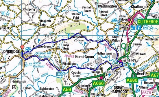
So how does The Tolkien Trail fit into the scheme of things? Many of us have explored and enjoyed the area around Stonyhurst for decades without a thought of Tolkien or Middle-earth. Local enthusiasts and the tourist board seem to have hit upon the idea in the early 2000s, conveniently at the height of the Lord of the Rings film series’ popularity: literary connections were made and leaflets printed, and it has increased in popularity ever since. It has been included in several guidebooks, and YouTube videos are freely available. There are no standout Tolkien locations for the Instagram brigade, aside from perhaps Cromwell’s Bridge, to distract the walker. This trail is all about the natural scenery, which one hopes the visitors appreciate.
I arrive in Hurst Green at lunchtime, the streets are packed with cars, signs implore considerate parking, and there is a small car park at the village hall (voluntary contributions). I know I am adding to the problem. Why didn’t I catch the hourly bus from Longridge or come midweek?
I tend to walk the route widdershins, thus avoiding that long drag back up from the river to the village right at the end of the day. Most of the leaflets and guides go clockwise, and this is reflected in the steady stream of folk coming towards me all afternoon. Without exaggeration, at least a hundred; at one point, I wondered whether there was a sponsored walk underway. But the wide landscape easily swallows them, and as I said, there are no real honey spots. On reflection, I don’t recall seeing any litter.
A wedding reception is in full flow at the Shireburn Arms, a popular venue with stunning views over the Ribble Valley. Through their car park, a gate leads into a field that drops down to the River Ribble. 


Towards the bottom, it narrows alongside a steep gorge before crossing the stream.


Alongside the river, the pipeline carrying water to Blackburn is a graceful addition to the scenery.  One is uniquely walking on Astroturf. A solution to prevent erosion on this popular stretch. Strips salvaged from an athletic track were laid down a decade ago and seem to be lasting well.


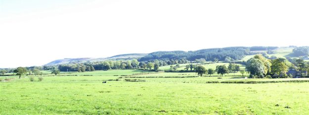
Pendle pops up on the horizon and is with us all day.
Yellow Loosestrife and Geraniums give some colour. 

Approaching Jumbles…

…and Tracy’s seat.

The giant hogweed we are warned against. Do not touch!

Hacking Ferryman’s house, Kemple End in the background.

17th-century Hacking Hall.

Site of the Hacking Ferry, which operated until the 1950s, Tolkien’s era. The Calder is joining in.
For more on the ancient ferry – https://bowlandclimber.com/2020/02/23/roads-to-nowhere-part-2-hacking-ferry/
All along this stretch, chattering Sand Martins are swooping over the river. One is just as likely to see a Little Egret as a Heron these days.

The Hodder is joining from the left.

The ancient Winckley Oak.

I learned to drive one of these before I was a teenager.

Stonyhurst College towers come into view.

That iconic bus shelter with a handy seat…

… and a view of Pendle.

C16th packhorse bridge. Cromwell’s army unlikely crossing.
One is now following the Hodder, which is mostly hidden by the summer vegetation. There are some good little bays for paddling along this stretch. 
And a lively weir further on. 
The trail climbs away from the river to Hodder Place, once a preparatory school for Stonyhurst College, but before that, a cotton mill owner’s property. Was there a mill on the Hodder below? I don’t think so, his must have been elsewhere..
I march through the grounds of Stonyhurst College before taking the footpath back to the village, arriving down Smithy Lane next to the photogenic Shireburn Almshouses.

Gothic Revival style St. Peter’s.


Almshouses.
I enjoyed my slow wander through our beautiful countryside and, like Bilbo Baggins, didn’t get lost once.
For a shorter version of this walk – https://bowlandclimber.com/2025/03/01/tolkien-in-the-mists-of-time/


 The fields around Blackmoss are studded with molehills; some look ginormous.


 We part company at Sainsbury’s, and I return home after a decent and interesting ramble. It’s not been easy taking pictures on my phone one-handed.


 It’s difficult to give an impression of the water’s power in a photo so I tried a video for better effect.
 Instead of returning the same way I picked up an unmarked track near one of the little footbridges; this took me up the hillside towards Rydding’s Farm, where walkers aren’t exactly welcomed with “dogs running loose” signs.
 I bypass them and take the farm track leading back to Birdy Brow. Looking back, a rather hazy Pendle Hill dominates as usual around these parts.
  I hadn’t walked far for my first walk of 2025. I’m pleased to see my car hadn’t been washed away and drove carefully back over the high road, stopping only to view the floods below in Chipping Vale.


 The quarry is hidden away just before the road starts its winding ascent. It’s late morning when I park up under the old Sykes Lead mine and the roadside Lime Kiln. The quarry faces west so should be sheltered from the easterly wind. A regular procession of motorcyclists pass me as I walk up the road to the gate.


 The clocks have changed, but my body hasn’t caught up as yet. Today had a sparkling alpine start and promised to be the best of the week. I struggled to get up having lost an hour somewhere. But with the minimum of faffing I’m away by 10.30. It only takes me a half hour to drive out to Dunsop Bridge. I know the sun doesn’t set tonight until after 7pm, so there is no rush, that’s the way I like it.


 The lime kiln gives a clue as to the bedrock hereabouts, but I shall soon be high in gritstone country.
 The track soon peters out, and I’m left on boggy pathless territory forever upwards. This is designated as a bridleway, and I remember coming this way on a mountain bike 35 years ago with my son. No chance now. This area is isolated from the usual Bowland haunts, and I’m surprised to meet three walkers descending the pass. A friendly trio and we exchange banter. They have driven up from Manchester, preferring this area to the crowded Peak District. They soon become a dot on this vast landscape as they descend towards the Trough Road and I struggle upwards. Across the way Totridge Fell keeps its head above most of the fells around here.


 Looking back I was surprised to see how steep and craggy are the northern slopes of Whin Fell. At Brennand Farm (notice how it complements Sykes Farm passed earlier) all is pleasant with newborn lambs in the fields, no Spring walk is complete without some lamb photos. On down the Brennand Valley and then strangely back upwards to join Whitendale.