Category Archives: Yorkshire Dales.

MISSION ACCOMPLISHED, CONFUSED ON CROOKRISE.

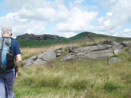
                                                   Crookrise and Embsay Crag in the early morning.

*

Most of what I have to say today is irrelevant. Putin is focused on invading Ukraine on false premises, and a peaceful nation is being annihilated.

*

The object of the day was to reach the trig point on Crookrise at 415m. Sir Hugh has had an ongoing mission to visit all the 76 trig points on OS map 103, mainly in the NW part of Lancashire, although today we are in Yorkshire. This would be the final summit, and he duly touched the shining white pillar early in the afternoon, congratulations on another challenge completed.

Fortunately, we had chosen a blue sky day and the views were sparkling. In the background, on the picture above, is the lovely little ridge of  Sharp Haw on the edge of the busy Dales town of Skipton. Down the Aire valley was all floods. In a northerly direction, the monument on Rylstone was prominent and the rift of Deer Gallows showed up clearly, reminding me of a long day when we climbed on all six crags on this edge of Barden Moor with a lot of rough walking between them.

Our rendezvous on this occasion was the free car park in Embsay village to make a hopefully interesting circuit, it turned out to be a full day in the hills. Above the historic village, once busy with mills, is the shapely Embsay Crag, and this was our first objective, although at the time we hadn’t realised it. In my mind, the path traversed below it en route to the reservoir, but no, we were slowly guided onto the summit. And what a summit, surrounded by gritstone craglets with a 360  degree view. The vast interior of Barden Moor with Deer Gallows, distant Beamsley Beacon, Embsay and its reservoir directly below, even more distant Pendle and the fell wall leading up to the Crookrise summit. Along the valley below, a steam excursion was puffing on the short stretch of restored railway.

C18th Embsay Kirk.


C19th Embsay Church of St. Mary the Virgin.


Embsay Crag.


Beamsley Beacon and Eastby Crag.

Looking back to Beamsley Beacon and Eastby Crag.


Embsay Reservoir and sailing club.

A problem was how to reach the route up onto Crookrise without loosing too much height, we failed and followed a decent path down to the reservoir. This took us past a secluded ghyll complete with a lively stream, magic.

Rough ground to Crookrise (top right)


Back up to Embsay Crag.

I was glad of not carrying a full climbing rack and rope up the steep track, past the perfect little boulders where we used to stop off for some warm up entertainment before the main event. Sir Hugh had promised a nostalgic visit to Crookrise Crag after the celebratory trig visit

Heading up newly flagged path.


Trackside boulders.


First view of the crag over the wall.


That trig point.


Floods in the Aire Valley.

 My regular climbing partner years ago lived in Skipton, still does, so Crookrise, on his back door, was a frequent venue for our early struggles on gritstone, I knew it well. From the trig point I thought I saw a way down to the base of the rocks – but our first attempt, and second, and third, ever more precarious, only landed us into a world of moss and conifers, many of those precariously toppled by recent storms. Obviously too far west. Back up to the top, we retreated several times and yet tried again without success. This was jungle warfare that stretched Sir Hugh, and I felt embarrassed and responsible. Let’s sit down and have lunch was my best solution. I didn’t know it as well as I remembered. I tried to distract him with views across to the splendid crag at Deer Gallows.

A tight squeeze.


Pulling on heather.


Temporary escape, time for lunch.


Deer Gallows and Embsay Crag.


Zoom to Deer Gallows.

Composure restored, we climbed the wall onto the access track and headed down the fell, our tails between our legs. More stiles were passed and investigated without any obvious ways down, but the last seemed to ring a bell in my memory. I was over and looking down on the End Slab of the main crag. Sir Hugh was ‘keen’ to follow, and soon we were stood below the slabs. The rock was in perfect condition, and I was regretting not throwing my rock shoes into my sack. But maybe my memories deceived me, the slab was steeper  and relatively holdless, drawing one on to even more difficulties higher up, which I may not be able to succumb. I was content therefore to admire smugly from terra firma. The rest of the crag stretching west into the trees will have to wait for another time, even I was loosing my enthusiasm.

There must be a way down.


At last.


Another time.


Can we go now?

Moving on…

Back on the descending track, we met up with a pleasant couple, ‘birders’ by the look of them, who were out for the day with their binoculars. In typical Yorkshire banter, they  commented on farmers, walkers and most emphatically irresponsible dog owners. On the whole, we had to agree with their sentiments, though we debated the finer points as we progressed down past the reservoir. Our contributions to bird watching were Greylag Geese on the water and Oyster Catchers swooping above.

Heading down.


Greylag Geese.


Oyster Catchers.

The industrial heritage of Embsay was in evidence, with mill chimneys and mill races as we entered the village past the Manor House. It was difficult to believe it was 4 o’clock back at the car, I’ve no idea where the time went. Sir Hugh hasn’t divulged his next project as yet.

Past history.


Manor House, 1665.


Could be interesting.

For Sir Hugh’s version of the day, see    conradwalks: Trigs 103 – Final trig of 76 – Crookrise Crag

and for those interested in the crags mentioned

UKC Logbook – Embsay Crag (ukclimbing.com)

UKC Logbook – Deer Gallows (ukclimbing.com)

UKC Logbook – Crookrise (ukclimbing.com)

    *****

SALT OF THE EARTH.

                                             Salt’s Mill.  Oil on two canvasses.  D Hockney 1997.

Titus Salt was born in Morley  on 20th September 1803, the son of a successful wool merchant. He joined the family firm, which became one of the most important worsted companies in Bradford. He took over the running of the firm in 1833 when his father retired, and eventually owned five mills in Bradford. The city became a horror story of the Industrial revolution, with poor working conditions, squalid housing, polluted air and water supplies. Life expectancy, of just over eighteen years, was one of the lowest in the country.

To improve matters, Titus decided in 1850 to move his business to a green field site where he built an industrial community on the banks of the Aire and next to the canal. Salt’s mill, Italianate in style, was the largest and cleanest in Europe. At first his 3,500 workforce travelled from Bradford, but to improve their lot over the years he built housing for them. He integrated into the Saltaire village:  parks, churches, schools, hospital, almshouses, railway station, public baths, libraries and shops. But no Public House. Clean water was piped in, gas for lighting and heating, and outside loos for every house. He did charge a rent for his properties but provided superior living and working conditions, a model of town planning in the C19th.

Titus Salt died in Dec 1876 having given away much of his wealth to good causes. The business continued under his sons but over the years declined, wound up and sold to business syndicates in 1893.  Textile production continued into the mid C20th and finally closed in 1986. The village itself had been sold to the Bradford Property Trust in 1933 thus enabling the houses to be bought by their occupiers.

An outstanding entrepreneur, Jonathan Silver, bought the Mill the following year and within months opened a gallery exhibiting the work of his friend, Bradford-born artist David Hockney. With Silver’s enthusiasm, the mill developed into the vibrant space we see today. He died young, but the enterprise is still run by his family.

Saltaire was added to the UNESCO World Heritage List in 2001, recognised for its international influence on town planning.

Well with all that write up it was time I paid a visit to Yorkshire. A wet Sunday in February was chosen. I drove through the floods down the Aire Valley. You realise the scale of the mill and village as you pull off the hectic suburban road.  The car park was busy despite the foul weather. As well as the historic buildings and the connection with the artist Hockney: the mill now houses cafés, upmarket retail outlets, artist materials, an excellent book selection, antiques, cycles etc. All waiting to make a hole in your wallet, though the parking and entry are free. I had come basically to see Hockney’s artworks, but was impressed with everything else that was on offer. Everything is on a grand scale here, from the size of the stone building blocks to the massive indoor floor spaces.


You enter into the long ‘1853 Gallery’ with works by Hockney from different periods as well as a large selection of artists’ materials, all under the gaze of Titus Salt. The walls are all windows, so ingenuity has been needed to display the Hockney pictures. Time to get  used to the large scale of this place.  Hockney started his career at Bradford College of Art school (1953–57) and the Royal College of Art, London (1959–62), Portraits have always been an important part of his works and some early examples are exhibited here…

Red Celia. Lithograph 1984.

Margaret Hockney. 1997 oil on canvas.

…as well as some of his more recent computer generated portraits.

The next floor up was a gigantic book and poster shop where I had to be extra strict with myself. The queue for the diner looked daunting. Somewhere behind in the depths of the mill was an antique centre, an outdoor outlet and an upmarket home and kitchen showroom.

Having manoeuvred around all these, I arrived in a long gallery with some of Hockney’s abstract offerings from his time in Malibu Beach.

Round the corner was a stunning ceramic installation depicting Batley and Bradford by Philippa Threlfall, 1972.

I eventually found the way up to the top floor where I sat and watched a video of the history of Saltaire from which I gleamed my information for this post. In the next room were some historical artefacts.

As you move around the galleries, there are views out of the windows reminding you of the extent of this building and the surrounding village.

The major Hockney exhibition was on the top floor. In the first space was a video presentation of his iPad and iPhone pictures using the brushes app, which he emailed to friends. They came up three at a time and were a variety of vibrant styles. The larger exhibition was entitled “The Arrival of Spring” – a series of iPad paintings done on different days from his car parked on a Yorkshire Wolds lane from January to May in 2011. He made the most of the portability and speed of using the hi-tech iPad, capturing  subtle changes in the light. He was able to print them out on a large scale

“These pictures celebrate fleeting moments of intense beauty, and remind us of the importance – and the joy we get from looking closely.”

I’m ready for Spring – aren’t you? Worth clicking for enlarged images.

I came out of the mill to a broody winter day with hail showers moving in. I wanted to have a look at some nearby Saltaire streets, under the shadow of the mill, before the light disappeared. The terraced houses were obviously now desirable properties, and the shops on Victoria Street appeared prosperous. Chic Yorkshire.

Next time I will give myself more time – a grand day out.

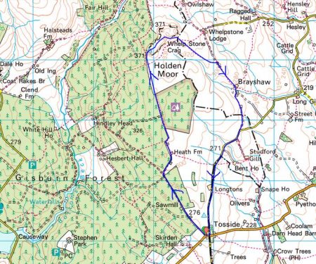
WHELP STONE CRAG – Gisburn Forest.

                            Distant view of Whelp Stone Crag peeping out of vast acres of Gisburn Forest.

I parked in Tosside; a church, a village hall, a war memorial in the middle of the road and an inn that is closed.

St. Bartholomew.

War memorial and ‘pub’


On the map the track leading to Whelp Stone Crag looked straightforward, a lane to a farm and then a footath alongside Gisburn Forest. As far as the farm the lane was good but the path onwards diabolical, difficult to follow on the ground, encroaching trees and waterlogged for most of its length. Why do I always seem to find these horrors?  I could hear the mountain bikers on the Gisburn Forest trails whooping with delight, I hope they could not hear my cursing. I would not recommend this approach, there are probably better traks within the forest.

The crag in sight over more rough ground.


Anyhow I arrived at the trig point, 371m, on top of a fragmented gritstone edge. Ravens were cavorting about in the updrafts. There must be some good bouldering on these rocks. From here I could look down on the bikers speeding along the trails. There were 360 degree views over Pendle, Bowland and into Yorkshire although the higher peaks were cloud covered. I was the only person up here.

After a snack as I was preparing to leave a couple arrived on the summit. ” That was the worst path we have ever been on” was their opening conversation. I had no idea what they meant.

The ongoing ridge was a delight before trackless slopes took me down to squelshy fields where farmers were rounding up their sheep. Across the valley, A65, were the limestone hills of the Settle area.

The unmarked footpath just about navigated me through or around, I was never sure which, several farms called Brayshaw. They all had a well worn look to them and were undoubtably of vintage.

Passing a smarter residence I reached some tarmac on a minor road. I threw in the towel and followed it back to Tosside. I think I was in Lancashire most of the afternoon but the oulook was Yorkshire Dales country.

*****

RIVER WENNING AND ‘THE BIG STONE’.

The River Wenning comes out from the Craven limestone dales and heads towards the Lune.  Today we were constantly reminded of the Dales by the presence of the Three Peaks on the horizon. The river takes its name from the old English ‘wan’ meaning the ‘dark one’ and within yards of the carpark we were crossing its rushing brown waters. These waters in the past powered mills in the Bentham area, originally for flax but later turning to cotton and silk. Here at Low Bentham modern accomodation has been developed in some of the old buildings.

It was a pleasure to walk upsteam chatting to Sir Hugh especially after the last few stressful weeks. Before we knew it we were in a massive caravan park, part residential and part tourism. We were impressed as to the quality of the park but what would you do here all the time.

After exracating ourselves from the park we climbed little used paths linking farms up the side of the fell. Some tidier than others.

Fourstones Farm

Once on the open fell the object of our walk appeared on the horizon across boggy terrain. The Great Stone of Fourstones stands on the Lancs/Yorks boundary. Known locally as ‘the big stone’, it is a glacial erratic gritstone. Originally as the name suggests there were three others which were broken up by farmers, but I can find no reference as to any dates or why one stone survived. A feature of the stone is a set of worn steps carved into the side, easier to climb than descend. I remember playing here with my children and finding more adventurous ways to the top. Today we were entertained with an ascent by a passing motorcyclist in his unsuitable footwear. The stone is covered in carved graffiti.

Leaving here we weaved a way across the fell to descend past interesting farms with the dramatic view of the Yorkshire hills ahead of us.

Gragareth, Whernside, Ingleborough and Penyghent.

Grusckham.

A late lunch was taken sat on a couple of stones only to pass a perfect wooden seat within a hundred yards. This is a frequent occurence on walks which remains an unexplained quandary.

Dawson.

From time to time we were strafed by Chinook type helicopters which had the conversation ranging to ‘Mash’ – Hawkeye, Hot lips and Radar. We are of a certain generation.

Back on the River Wenning we bypassed Higher Bentham village using a lane by riverside mill cottages. Once through another large caravan park we took paths on the north side of the river to Lower Bentham.

Sleepy Lower Bentham.

Yet another interesting walk in unfamiliar territory. Are there more in this area?

*****


A SETTLE CIRCULAR. Second day.

“I may not have gone where I intended to go – but I think I’ve ended up where I needed to be”  Douglas Adams.

As I slogged up the steep lane out of Stainforth I was regretting the good and filling breakfast I’d just eaten in The Craven Heifer. I’d had a quick look around the churchyard, crossed the stepping stones over the beck and then followed the Pennine Bridleway signs. At the top of the lane was a gate giving access to some more spectacular waterfalls – Catrigg Foss. A placid beck wanders through upper pastures before disappearing into woods. Looking down from the top only revealed a very steep ravine with the water rushing way down below, it was time to explore the lower reaches by a steep path. The falls tumble down in two stages through vertical strata. A magic place to while away time.

Back on the Pennine Bridleway, I cross fields to reach a footpath going towards Attermire, passing a prominent erratic on the way. The day was not looking good with low cloud covering all the tops, down to about 400m. The bridleway I was intending to follow would be in the mist all the way to Ryeloaf Hill which couldn’t be seen – my resolve faltered. I was close to Jubilee Cave so I thought I would climb up to have a look not having been here for years. The two entrances were obvious and I went into the main one but didn’t explore further. This cave and several others in the area have been excavated finding animal bones from before the last ice age and evidence of early human since. There is a large platform area outside the cave, more evidence of human activity, where I sat and had a coffee and debated the day. Why not explore a few more caves at Attermire and then take a shortcut to Rye loaf if the cloud lifts.

So I took the footpath leading around the corner passing Wet Cave … … just spotted on the photo that good looking layback crack to the right of the cave.

Higher still was the larger Victoria Cave, discovered in 1837 and excavated extensively. Plenty of animal bones were found. The earliest, at 130,000 years old, [Upper Pleistocene interglacial]  when the climate was much warmer than today, included hippos, rhino, elephants and spotted hyenas. The glaciers returned and the cave filled with clay.  After the last Ice Age brown bear and reindeer bones were found as well as an 11,000-year-old antler harpoon, the first evidence for people in the Yorkshire Dales.  More recent Roman layers yielded bronze and bone artefacts including brooches and coins. The inner depths of the cave are now barred to preserve any further archaeological finds but I remember years ago exploring deeper connecting passages.

Returning down to the main path which goes south through the gap between Warrendale Knotts and Attermire Scars.

The back of Warrendale Knotts.

This area was one of my favourite climbing venues with a whole range of buttresses and tiers of limestone, all facing south and giving a huge variety of routes.  The scene as you approach the rocky crest from the south reminds me of those old cowboy films when hundreds of Indians suddenly appear along the horizon. Today one could hardly make out the features shrouded in mist. Anyhow, I walked on to find the trod leading up through the screes to the long escarpment where I remembered Attermire Cave should be.

It seemed much steeper and exposed than I recall but I think the mist added to the atmosphere. I reached an area of solid rock which I recognised from past climbs, Hares Wall etc, some of the best VS to E1 routes hereabouts. The vertical rock is immaculate limestone with cracks and pockets leading to overhangs higher up. I was pleased to identify so many climbs but I couldn’t find Attermire Cave itself. Exploring around the corner I came across the vertical cleft of Horse Shoe Cave, more of a landslip than a cave. Now pacing back and forth along the base of the cliffs I remembered that the cave I was looking for was on a higher shelf. [It’s there on one of the photos above!]  So  I scrambled up at a likely spot and traversed airily along a ledge to an exposed step into the mouth of Attermire Cave. The cave entrance is smoothed off from the previous flow of water, phreatic, and one can walk in, under an ominous wedged boulder, for several metres before a crawl takes you through to another chamber. I was not equipped for crawling today but the light on my mobile illuminated the outer large chamber well enough. Again this cave has yielded animal remains but also more recent human artefacts including of all things part of a chariot suggesting the cave had some spiritual significance.

Views were restricted so I retraced my steps carefully and descended the screes below. In the valley floor, previously a lake at one time, are metal targets apparently commissioned in the C19  when it was thought France may invade. They were used again before WW1.

There was no point going up the valley to climb Ryeloaf Hill as it was completely obscured by the low cloud. Another time. To save the day and incorporate a ‘loaf’ I climbed the easy low Sugar Loaf Hill on the way back to the car.

On reflection, my amended walk would be better called ‘Caves and Fosses,  AKA Loaves and Fishes’. I had made the best of today’s weather by keeping low and searching out those caves. I ended up climbing 20000ft in the space of 5miles.

*****


My Settle Circle below…

Caves and Fosses Walk.

A SETTLE CIRCULAR. First day.

You often hear the sound of crashing waterfalls before you reach them. A sign off the road directed me to Scaleber Foss in a wooded valley. Scrambling down to the base gave the best views as the water cuts through the horizontal strata. There are some lively smaller falls before  the beck disappears down a valley at a more sedate pace to be met later.

I had just started another walk plucked from the LDWA database. A circular 23-mile walk in Limestone country from Settle in North Yorkshire named  ‘Loaves and Fishes’. I enjoy a two day walk away from home, I’m not sure this brings it into the long-distance category but it is a good excuse to have a night in a pub halfway. Considering the winter days and my level of unfitness this walk would seem to fit the bill perfectly. At the last minute, whilst parked up at the start I changed the direction of my walk to fit in with the weather forecast, rain today and maybe drier tomorrow when I would be higher in the fells.

Back up onto the road, I was soon on an old lane following Brookil Gill, this is Langber Lane an ancient drove route linking Settle with Otterburn and on through to Skipton. Easy walking left me thinking on important topics: the state of the world politics, our future after so-called Brexit this Friday, Coronavirus, our own mortality and is that water getting into my right boot?

After a hop across the beck, a path continued into pasture land where the stream from Scaleber Foss joined at a wooden footbridge. An ideal wild camping spot.

A steep climb out of the valley and I joined a lane overlooking Long Preston, one minute I could see it and next clouds and hail showers obscured the view. As I came out onto a road there was a bench perfect for an early lunch. I’m not sure why this road heading onto the moors is surfaced, there are no properties up there. On old maps it is Queen’s Road [? Elizabeth I ] and was the direct route from Long Preston to Settle over Hunter Bank before the turnpike road was built in the valley in the 18C. An old milestone was thus inscribed.

Dog walkers told me of the fine views up and down Ribblesdale, not today. Once over the top, I took to a direct footpath and a blurry Settle appeared below me. Little lanes, some still cobbled, thread their way into town. I took a coffee and dried out in The Folly, a late C17th manor house built by a wealthy lawyer Richard Preston.

I didn’t have time for more coffee and cake in the Ye Olde Naked Man, formerly an undertakers with a ‘naked man’ on the outside wall, 1663 covering his privates. There were more delights to discover off the beaten track in Settle. Narrow streets, quaint cottages, a Quaker burial ground and an old Victorian Music Hall.

I was aiming for a footbridge over the Ribble and then I would follow the river upstream past Stackhouse and Langcliffe Weir to Stainforth. The imposing large quarries at Langcliffe were in the gloom. I must be on a Long Distance Walk according to the signage. The going was muddy and by the time I arrived at Stainforth Falls, the light was fading. Sat-Nav is responsible for wide vehicles becoming stranded and damaging the old packhorse bridge.

I stayed the night in The Craven Heifer,  a friendly and comfortable inn. There are a number of pubs named after the Craven Heifer, a massive cow bred on the Duke of Devonshire’s Bolton Abbey estate at the beginning of the C19th.

The restaurant was fully booked for a Chinese New Year banquet but the chef was able to cook a fish and chip supper for me in the bar before festivities commenced. There was talk in the bar of a new virulent virus spreading in China.

The fish was significant as it was the only one I saw all day – remember the title of the walk. The loaves come tomorrow but the fish are the salmon seen in October/November leaping the falls at Langcliffe and Stainforth, not my battered variety.

Gung hay fat choy!

*****


BARDEN MOOR AND RYLSTONE, last of the summer wine.

A vigorous day visiting old haunts with wide-ranging views.

The Duke of Devonshire, Bolton Abbey Estate, owns a large area of grouse moorland NE of Skipton. Confusingly Barden Moor to the west of the Wharfe and Barden Fell to the east. I’ve spent many days on these moors mainly on their edges climbing on Rylstone Crag, Crookrise, Eastby and Simon’s Seat. I felt it was time to revisit and make a walk of it across the moors. The Pieman doesn’t get out much so when he phoned suggesting a walk this week I gladly agreed and decided on this walk on his local hills. I cajoled JD into the party to show him a new area. Wednesday was the day and the forecast was for improving weather, but first we had to get rid of the tail end of Hurricane Dorian. Early morning and the rain was still heavy, I even had a phone call from Skipton querying opting out but I’m made of sterner stuff. Miraculously as we drove across the skies cleared and the sun came out, there was a sneaky breeze when we met in Rylstone.

Rylstone with its duck pond and church; the famed ladies who produced the original nude Calendar;  the inspiration for Wordsworth’s 1808 poem ‘The White Doe of Rylstone’ and above the village Rylstone Cross.  The latter was visible on the fell as we set off but it would be several hours before we stood alongside it.  Originally a stone figure, the ‘Rylstone Man’,  changed to a wooden cross to commemorate the ‘Peace of Paris’ in 1814. This had to be replaced several times until the wooden structure was replaced by a stone one in 1997. I remember a wooden cross held by a metal frame from early trips to Rylstone Crag.

A bridleway climbs away from the road and was followed easily into the heart of the moor. We chatted away and hardly noticed the increasing tailwind. The heather, unfortunately, was past its best. Views started to open up to familiar hills but putting a name to them often eluded us. Simon’s Seat across Wharfedale was prominent. Upper Barden Reservoir came into sight and veered off on a track to it.  Sitting on an ancient stone gatepost out of the wind we had an early snack. Across the dam was an old waterboard house, we speculated on its value – isolation and views against accessibility.

The estate has signed most of the tracks and we changed course once again heading back to the moor’s northern edge.  Another small reservoir was passed and we focused on an old chimney up the slope, this with some obvious old pits suggested past mining activity.

As we reached the edge I regret not diverting a short distance to look at Numberstones End, a small gritstone crag.

By now the wind was almost gale force and difficult to walk into, JD’s hat became the focus of attention as it somehow stuck to his head. We took our second break in a beaters’ shelter, the shooters more commodious lodge being firmly closed. We gazed across upper Wharfedale to Grassington, Buckden Pike and Great Whernside, Grimworth Reservoir with Nidderdale behind. The Three Peaks were hidden in cloud.

Refreshed we commenced battle with the wind as we bypassed Rolling Gate Crags and made a beeline towards an obvious Obelix, Cracoe War Memorial erected to honour the dead from the Great War with a plaque added for the 2nd WW. It was difficult to stand up on the summit because of the wind and we set off down the ridge towards Rylstone Crag and its Cross. Now below was the limestone country around Cracoe and the contrasting greens of the Winterburn Valley.

A visit to the base of the main face of Rylstone Crag was obligatory to gaze up at President’s Slab, Dental Slab and all those other climbs that have given me so much pleasure in the past. Last climbed six years ago.

President’s Slab.

Dental Slab.


The cross was another gale swept vantage point now looking towards Pendle.


  A couple of boulders took our attention and we played around trying to stand up in the hole or reach for an edge, only long-limbed JD was successful with the latter. We reflected on ageing bodies and ‘the last of the Summer wine’ as we trotted down the hill back to the car, getting out of the wind and enjoying the warm sunshine.

*****

Not a grouse was shot during this walk.

*****

NORTHING 438. SALTAIRE TO HORSFORTH [LEEDS]

What could have been an uninspiring day in the hinterland of Bradford and Leeds turned out to be almost a green corridor of pleasant walking. It was not difficult to keep close to our lateral line with the proviso from Sir Hugh to incorporate a visit to his primary school in Thackley.

From the rail station in Saltaire we quickly reached the Leeds – Liverpool Canal to follow it off and on throughout the morning. At first all was industrial, historically relating to the canal with some fine mill buildings brought into the 21st century.

There were a few scattered sculptures including this one which was a pun on the Salt Mill connection…Hanging on the wall of my garage is an Ellis-Briggs cycle frame, probably 40years old, so I was delighted to pass their establishment which has been building steel frames since 1936. The cycling scene was booming in the 1930’s and the other notable established builder was W.R. Baines, whose factory was based at Thackley, see above and further into the walk. Coincidentally I rode a 1950’s Baines ‘Flying Gate’ cycle for many years.


Some nondescript scenery followed enlivened by some dubious and unsuccessful canal boat manoeuvering, it is difficult to do a three point turn.

Climbing away from the canal on cobbled paths above railway tunnels we entered Thackley, a mixture of old stone houses and modern estates, and found Sir Hugh’s school still open and extended since his time. Up here was the local cricket club with a very challenging sloping pitch, Sir Hugh’s father had been a member.

From the map we were not sure whether we could access the canal towpath from open country but thankfully there was a bridge. Soon we were sat on a bench looking down locks near Apperley Bridge, this was a busy stretch with pedestrians but no boat movements.Crossing busy orbital roads took time unless there were lights. We switched from the canal to follow the River Aire alongside the sports grounds of Woodhouse Grove School. The river continued through remarkably rural scenery despite being close to the railway and new housing developments.

Pleasant suburbs gave us twisting streets heading for Hawksworth Park which turned out to be a wooded valley. More parkland and upmarket housing and we arrived at our excellent budget hotel for the night.

*****

SKIPTON TO LONGRIDGE 1 – another straight line.

Skipton to Barnoldswick.Following on from the success of the straight line from Longridge to Arnside completed with Sir Hugh at the end of last year I have persuaded ‘the pieman‘ a resident of Skipton to undertake a similar scheme between our respective abodes.

The Pieman.

He is a lifelong friend, possibly blood related though I tend to ignore that, with whom I’ve shared many backpacking trips throughout Europe but recently we have not been able to meet up as much as required. So this was a good opportunity to get 2019 off on a better note. Thus I was drinking coffee in his house in Skipton early this morning before setting off on what could only be described as a drab day.

My local guide takes us across Aireville Park, where I used to play as a child, over the Leeds Liverpool Canal and out of town through an industrial estate with some interesting relics awaiting restoration.

Airedale Park.

We crept under a main road and crossed the placid River Aire on an old track into Carleton. This essential bridge for our route was just within the mile either side of our arbitrary straight line  The C19 mill in the village was originally for cotton-spinning but I remember buying carpets there in the 70s, apparently it is now luxury apartments.

Carleton.

Today we didn’t visit the village but took to unmarked footpaths through green drumlin fields. I have to concede that satellite tracking maps were a great help in navigating this section. We were going parallel to a disused railway [Skipton to Colne] and eventually we found ourselves walking along it for convenience until stopped by vegetation.Possibly we touched on a Roman Road leading to Elslack where there was a fort. Our priority was to find a picnic bench and there right in the middle of the hamlet was one in some sort of memorial garden. Having put his instant coffee powder into a cup he looked for the flask containing the hot water, unfortunately it was on the worktop back in Skipton. I had hot apple tea in my flask so he ended up with a strange brew.

We walked past the C15 Elsack Hall but at a discreet distance and then along the abandoned railway into Thornton-in-Craven joining the Pennine Way for a short stretch. The village has interesting old houses but no shop or pub and the heavy traffic deterred us from lingering.

Tree planted for the Coronation of Queen Elizabeth.

?Millenium Clock.

On the edge of the village are Almshouses built for poor women, there is not much of that charity evident today.

By the church a sign guided us to a Holy Well in the grounds, dating from Saxon times it is covered by an octagonal structure erected in 1764 by the rector.

On a short stretch of golf course we joined The Pendle Way. It weaved around a church and graveyard where every grave was decorated with flowers, presumably from Christmas.

Rolls Royce have a large presence in Barnoldswick and we passed one of their factories before joining the Leeds – Liverpool Canal for the final stretch into town. My overall impression today was of green fields and a rich historical background.

*****

TWISTLETON SCARS. Climbing on the SW Face.

The main crag at Twistleton hosts many low grade classic limestone climbs and was once a regular venue but slowly the polish increased meaning it fell out of favour with my group of climbers. Thats a shame as the rock was of such good quality and the situation in Chapel-le-Dale spectacular with Ingleborough brooding above on the opposite side of the valley. I wonder if due to less people climbing, not just because of the polish but with the rise in popularity of bolted routes and bouldering, left to nature the rock may roughen once more.  A few outlying crags were developed but we found these a bit short and scrappy, nowhere near the quality of the main crag. The exception to these was a separate area the South West Face, a small compact crag which in fact hosted some of the earlier climbs on the scar back in the 60’s Allan Austin era. This area had avoided the excesses of the main crag particularly no groups and remained a bit of a connoisseur’s area with climbs only on the lower grades.

My gardening induced shoulder pain had stopped me climbing for a few weeks so for today’s outing with Dave I wanted something gentle and he volunteered to do all the leading to tempt me along. He had taken a bit of a beating on gritstone the week before so when I suggested the SW Face limestone he was happy. My day didn’t start well as the cheap Aldi trousers which I had climbed in for over a decade finally disintegrated, a sad loss.  It is so long since either of us had been in Ingleton we were not even sure of the lane to take leading to the crag and once on it were surprised by how narrow it was. Anyhow eventually it straightened out [thought to be of Roman origin here] and we were in the correct valley, the northern side of Chapel-le-Dale. Ingleborough was indeed brooding over us and the show caves on its flanks seemed busy with cars and coaches, it was a lovely Summer’s day.

As is usual the approach to the crag seemed longer and steeper than in our younger days. On previous visits we had probably ticked most of the climbs but had to get out the guide book to reacquaint ourselves.

The start of the starred VD above our sacs looked a bit bold and sketchy so we looked elsewhere for a warm up route. The short easy one we did convinced us of the quality of the rock here and the lack of any polish so we were feeling pleased with our choice of venue. Back to that VD, well maybe not yet. There was a good steep climb left of the tree which followed a line of solid flakes that was very enjoyable. After a leisurely lunch soaking up the sun we avoided that VD by climbing a series of jugs up a steep rib – not a bad move on the route whose name gave a clue. After that we couldn’t procrastinate any longer. A closer look at the steep wrinkled wall in front of us revealed small flakes and even a crafty threaded runner so Dave had a sequence worked out and was soon finishing on the upper wall. The climbing was indeed quality but we both thought under graded for an onsight ascent. To finish the day there was another starred severe crossing a black wrinkly slab round the corner. The start was uninviting and the traverse unclear, though I don’t remember on past visits any difficulty. Anyhow I was in Dave’s hands today and he found an alternative start further right which used flakes to climb more directly up to the superb finishing wall, could even be a new variation route.

The pictures may give some indication of the quality of the rock, the vegetation was not a problem. The climbs were only 10m or so.

Tree Stump Crack D

Tree Wall S *

Juggernaut S **

Play For Today VD ? *

Twinkle Variation S *


THREE DAYS IN MAY. 3 – CLIMBING AT POT SCAR. Almost perfect.

Third time lucky. Things have changed in the tiny hamlet of Feizor where you always felt you were intruding into the residents’ private territory. Someone has opened a tea room which is proving very popular. The added benefit of this is that lots of parking spaces have been provided in a yard whereas in the past parking was fraught. Honesty box for the Air Ambulance, you never know when you might need them.  It’s a short pleasant walk up to the limestone crag of Pot Scar in the midst of classic Dales scenery, rolling green fields and all those stone walls. In the background is Ingleborough and across the valley distant Pendle and the Bowland Fells. Wary of the polished routes on the main face  [I recall climbing here 40 years ago and witnessing that polish developing gradually on the classic lines of Nirvana, Addiction, LSD etc, there was a name theme here]   we head left to a little buttress with routes suitable for us oldies. The sun is shining and the day warms up quickly despite there still being a brisk wind. The first easy climb is on perfect cracked limestone with no hint of polish, maybe nobody climbs this end. For the second climb I become entangled in trees and vegetation on what would have been a good line, Dave admonishes me for all the delay gardening. Lunch is taken in the sunshine looking at the scenery with the occasional party of walkers going through to Stainforth, no other climbers appear. I next enjoy a steep crack climb with quite reachy moves and the usual grassy mantelshelf near the top. Despite warnings of loose rock Dave quickly climbs a crack, a tree and a flake, as I follow a lot of the holds disintegrate. Another steep crackline and we are ready for home but well satisfied with the day’s climbing. Next time we will visit the cafe and then try the polish.


Half way up Domino.

Out of the tree on Periwinkle.

Finishing Feizor with Domino to the right. Notice the blue sky.

For the record…  Fingers Climb D,  Dodger VD.  Domino S.  Periwinkle VS.  Feizor S.

THREE DAYS IN MAY. 1 – CLIMBING AT ATTERMIRE. Too cold.

Sitting in Dave’s garden this morning drinking coffee in the warm sunshine  – what  a great day it was going to be. We decided on a trip to Yorkshire with a visit to Attermire Scar for an outing on limestone.

Neither of us had climbed here for years although at one time I was exploring here regularly with my cousin from Skipton, long evenings and walking out in the dark. There was often a bull in the field! I remember also an occasion, ?20 years ago, achieving 1000ft of climbing in a day as part of a sponsored event to raise money for a climbing wall in Clitheroe. That was a lot of routes. Each sector has its own character and memorable climbs Hare’s Wall, Fantasy, Brutus, Red Light, Flower Power.

When we parked up there seemed a change in the weather, the sun had gone and there was a northerly wind. But relying on the good forecast we were not unduly concerned, though I did throw in an extra fleece. It’s a great approach walk as when you breast the rise the whole extent of the scar is displayed in front of you reminding me of a set from a Western cowboy movie, I half expect to see Apache warriors appearing on the tops of the crags ready for an ambush.

Today we make the long traverse to the SW end passing under Legover Groove area, all the climbs here are tough. There is one line of weakness, Ginger VD, this will be our warm up. As I climb lovely big holds up the steep start I realise my hands are freezing, the temperature has dropped and the wind is blowing strongly across the face. A committing blank move left at half height on more compact rock has me thinking. Then it is simple to the top as the angle eases, grassy top outs are common here and care with choice of belays in the blocks is needed. The wind was even stronger up here and I was glad Dave climbed quickly. Back at base more layers were added and hot tea drunk.

The slab in the middle is Ginger.

We moved along the crag but could not get out of the wind. As I climbed the next route, Wrinkle Slab VD, Dave gave commentary on a cloud that tantalisingly hid the sun whilst all around the sky was blue. I was constantly having to warm my fingers to feel the small flaky holds. I wasted time by going left rather than right at half height which meant reversing and faffing with runners. By the time Dave came up his fingers were white and we knew it was time to retreat, we never did warm up.

Unlucky choice of crags and weather.

Under Wrinkle Slab, ready to go home.

SIMON’S SEAT.

Bolton Abbey Estate riverside car park Tuesday 10am.

£8 please.

Eight?!

Yes it’s half term. But if you had come last week it would have been £4.

It has been in the news this week about airport carparks doubling their charges for school holidays so this is just another example of greedy businesses taking advantage of families. Rip off Briton.

The ‘pieman’ and I set off on today’s walk in a grumpy mood. We had chosen today to climb Simon’s Seat as there was sunshine forecast. Way back this was a regular winter walk for us, then we would extend the route to include the moors above Appletreewick [an interesting name] and Trollers Gill. A straightforward 9mile circuit was planned for today. The paths seemed to have changed now that the land is open access, I seem to remember sneaking in to some of these areas. At one time we also had a major offensive on the climbing routes on the summit rocks of Simon’s Seat – an atmospheric place to be on a summer’s evening. Stand out routes were Arete Direct VS and Turret Crack HVS. See later photos of crag.

The path into the estate passed by some ancient oak trees which must have been several centuries old. The Valley of Desolation was entered and the stream and woods followed upwards – the name derives from a storm in 1826 when most of the vegetation was destroyed but not the oaks obviously. A hidden waterfall was glimpsed through the trees. Once onto the open moor a cold wind kept us on the move. All the surrounding fells had rocky outcrops but we were heading for the highest group of gritstone, 485m, Simon’s Seat itself. The land rover track passed the shooters lunch stone. Scrambling up the summit boulders was tricky with slippy snow scattered on the rocks, it was still winter up here. Goback called the grouse. dsc05552

Below the crag we found a convenient lunch stone of our own, out of the wind, with views over to Perceval Hall and beyond. Classic Dales scenery. Reminisces of shared past trips kept us humoured, the Pyrenees, Greece, Turkey, Dolomites, France, La Gomera, Spain. Above we could trace routes on the rocks. We have been lucky.

Our lunchstone.

Our lunchstone.

The classic arete on the left of the crag.

A paved track cum water course took us steeply down into the valley where we joined the Dales Way, another old favourite. We now met people strolling the river bank commenting on the lovely weather – no idea what it was like up on the tops. We kept to the left bank path on the Wharfe which proved ‘undulating’. Good views down to the deadly Strid though.  https://www.youtube.com/watch?v=mCSUmwP02T8

The car park was full of £8 vehicles when we arrived back at the busy Pavilion. Coffee at the pieman’s was the most economical option before driving home.

ANCIENT WAYS.

Beamsley Beacon and Round Hill.

Two ancients going their own way.

There will be lots of posts with Autumn colours at this time of year, I went abroad a week ago whilst the leaves were green and have returned to spectacular trees. But today I hardly saw a single tree on these bleak moors. The general visibility was poor also but a combination of The Pieman and The Rockman as companions was sure to provide an entertaining day.

I have driven below on the A59 hundreds of time and looked up at the craggy top but I had never ventured up there. By our roundabout stroll we found were reminders of ancient routes long before the present roads. There were numerous old mile/directional stones and many boundary stones suggesting lots of foot and mule traffic at one time. Tracks tend to connect and the places mentioned on the stones give some idea of destinations. What was the nature of peoples travel – monastic or trade routes?  – people certainly wouldn’t have come up here for pleasure. On the map there is also a Roman road shown but no trace of this was passed today. The whole area was rather boggy, an understatement, and progress was slow and must have been troublesome for those who passed before. There is no trace of paved mule routes here, whereas in many Pennine areas these are an outstanding feature. On the map there are mentions of ‘cup and ring’ stone markings but we didn’t notice any, didn’t look hard enough.

Enough of way stones – there didn’t seem to be many obvious paths…Up on the drier heather slope there had been some harvesting of the heather which was bailed up – to be used for what? There was yet another mystery, two detached boot soles.

Having traversed Round Hill [409m] we arrived at Beamsley Beacon itself [393m], a more popular destination being a short walk from the car park. The prominent Beacon was part of the chain of fires that could be lit as warnings during the Napoleonic wars, recent uses of these beacons have been more celebratory. The large stone cairn is thought to be a Bronze Age burial site but has never been excavated. The trig. point bares a memorial to a crashed Lancaster Bomber crew from the Royal Canadian Air Force killed 5th November 1945.Will have to come back for the views.


MORE YORKSHIRE GRIT – EASTBY CRAG.

I must have climbed here as much as anywhere over the years as one of my original climbing partners lived in Skipton. Looking back at my red 1974 guide it is well ‘dirty’ thumbed.  The front cover features Allan Austin climbing at Ilkley with the rope tied round his waist and it was he who pioneered many of the outstanding lines at Eastby. The routes here tend to be slabby and when a subsequent guide book appeared YMC brought in P grades:

P1 Well protected with falls only damaging egos,

P2 Bolder, sparse protection with plenty of air time, could be painful,

and P3 You will be lucky to walk away from a lob, get life insurance.

It was then we realised how challenging had been some of the slabs, particularly pre-Friends. Nonetheless the classics were slowly ticked Knuckle Slab, Mist Slab, Nose Climb, Whaup Edge and even The Padder although I never could muster up the courage to lead Pillar Front. This crag is relatively low lying, dries quickly and gets any sun going so I think we often visited early in the year before venturing onto the ‘mountain crags’. So today, almost August, we were surprised by the vegetation, fortunately a track wove up through the head high bracken, it was like being in a maze.  You no longer have to have written permission from the Cavendish Estate to climb here, sorry I’ve misplaced my permit.We were beaten by a few minutes to the base of the crag and left the only other team to start on the well trodden Eastby Buttress. We went right to below Knuckle Slab but chose easier climbs to start. Birch Tree Crack was a mistake, despite being a good line many holds were obscured by vegetation. Scoop and Crack was much cleaner and I, with prior knowledge, avoided the finishing boot wide crack [unprotected ankle scraping and thrutching]  for a delicate step left onto a slab. That’s more like it. The descent was as hairy as the climbs ?P2.

Now we were able to get onto Eastby Buttress …… and enjoy some classic wall and crack climbing. Once your wrist is locked into a crack just pull up and find somewhere for your feet – repeat and repeat and you are at the top. Great views of Pendle and Longridge Fell in the distance and down below little steam trains chugging along on the Embsay & Bolton Abbey line.

We finished on Nose Climb Original, a steep wall pops you onto a holdless slab to run up and reach a  final secure jamming crack.

Not a P3 in sight.

CREAKING GATES ON ROLLING GATE.

Climbing at Rolling Gate.

It’s the hottest day of the year with temperatures in the 30s. This high Yorkshire crag faces NW and seemed an ideal choice for the conditions and so it was. A sweaty walk deposited us in the shade of the scattered rocks which form a rather broken edge.                                                      The obvious start was Veterans Flake which wandered about to eventually surmount the large flake, all a bit of an anticlimax. It was however pleasant to belay on the top in a breeze with views over Grassington into upper Wharfdale.                                                                                  Next up was Long Crack a proper gritstone thrutch around several noses in a corner, sweaty work today. The descent  brought us to the foot of The Main Buttress and the start of Rolling Gate Buttress the starred route of the crag. The first steep and bold 10ft seemed hard, my left hand reluctant to leave a decent slot for small slopers above with only slanting footholds – surely not severe. Eventually a hand on the arete enabled my feet to move higher and the ‘better’ hand holds above reached, heart in the mouth stuff. Then large ledges were shuffled onto and left insecurely round bulges with no protection, I’d not brought the big friends. Don’t seem to remember it being this hard 40 years ago!

Rolling Gate Buttress.

Rolling Gate Buttress.

We retreated to a shady corner for lunch and composure, our gates were certainly creaking and our resolve weakening in the heat. However to the left was a rib leading to a cracked wall which looked inviting, The Pillar, and we couldn’t resist. Easy climbing up the right side of the lower rib was almost alpine in nature. A stance was taken below the top wall which close up looked steeper and longer.  Once committed a lovely sequence of slots, ledges and cracks led to the top on perfect gritstone – the best of the day. We only wished it could have gone on for another 50ft but life is not like that.

I finished with a quick solo of Six Metre Wall, there are lots of other good looking boulder problems hereabouts.

Fortunately we arrived back at the lane just as the farmer was wanting access for contractors with oversized trailers. [they were in a rush before tomorrow’s potential heavy rain] We thought we had parked responsibly but could now appreciate his problem and were soon on our way. What a change however to meet a pleasant and chatty farmer, in the circumstances, to round off our great day out.

SHARP HAW – Skipton.

Sharp Haw.

Sharp Haw.

Sharp Haw is not quite the Matterhorn of Skipton but it is an eye catching shapely fell standing like an island in the Aire Valley. Driving across from the west this morning its numerous peaks promised a day of exploration. Dragging The Pieman away from his garden we parked at the start of the track saving a couple of miles walking in the day. On our last visit we had just walked out of his house in Skipton but I think we were both feeling lazy today. Instead of following the bridleway over Flasby Fell we headed over rough ground to the rocky ridge overlooking Gargrave to make the most of the views. All around are familiar hills, nearby is the Embsay/Crookrise/Rylstone ridge whilst Waddington Fell, Longridge Fell and Pendle are prominent to the west. There is a birds eye view down the Aire Valley with its enclosing hills. As we made our way along the crest gritstone boulders littered the ground and there was evidence of chalky visits, UKC now lists over 200 boulder problems for this fell. The Pieman showed me a particularly nice slab which he used to solo as he passed on his regular fell run. A quick ascent had me pleased. Next stop was across some boggy ground to the shapely summit and trig point, this was already occupied by two girls so we dropped down through the woods and found a classy metal bench for lunch and putting the world to right. [Memorial to a Helen Handley a local artist and politician].

Pendle, Longridge Fell and Waddington Fell with Gargrave below.

Pendle, Longridge Fell and Waddington Fell with Gargrave below.

–

Coming out of the woods we went through Flasby hamlet, all of six houses, and into the parkland of the Hall. All well manicured English scenery.  A short stretch on the road took us past the stately Eshton Hall  where my guide for today had attended when it was a school, he thinks it is apartments now. After a few fields we were on the towpath of the Leeds – Liverpool canal for a couple of miles back towards Skipton. A friend lives on a barge here but I think the other side of Gargrave. Uphill lanes were followed through the scattered houses of Thorlby and Stirton where most of the farms have been upgraded to exclusive living. More interestingly by the road side is a ‘Tin Tabernacle’, a disused Methodist chapel built with corrugated iron probably at the beginning of the 20th century. The Pieman can remember his father auctioning off the harvest festival products for chapel funds many years ago. I wonder how long this building will last and if it is listed, you don’t see many now.

Eshton Hall.

Eshton Hall.

So if you are in this area maybe eschew the higher hills and explore this rocky island.


Gone with the wind.

Giggleswick Scar, Dead Man’s Cave, the Celtic Wall and more.

The ‘pieman’ and I have postponed several recent meetings because of bad forecasts, it was no different for today but we said “what the hell”. And so we found ourselves being battered by 50 mph winds on the limestone pavements above Giggleswick. Wainwright’s Walks In Limestone Country gave me some ideas, always dangerous, and I wanted to visit some of the out of the way features. I cannibalised three of his walks into one rough itinerary. Living in Skipton I presumed the ‘pieman’ would have up to date maps of the area around Settle, but no – so we had to make do with Alfred’s drawings, as good as any map I would say. The only problem being my copy was from 1970 and not all the wall gaps still exist so we had some fairly hairy up and overs, no walls were damaged on this walk!

First off was Schoolboy Cairn, above that big quarry, maybe had something to do with Giggleswick School down below. A  high level promenade above the bypass road gave us a gale battered but splendid bird’s eye section above the South Craven Fault.  The floods in the Ribble Valley below were all to obvious. We clambered up to the conspicuous Wall Cave, the wall seems to have gone, from where we had a view across the golf course. apparently there was previously a tarn here. There are lots of strange features in this limestone area. Below us somewhere are the popular bolted climbs on the steep scar.

Spurning other caves we marched along to Buckhaw Brow, the garage and cafe of Wainwright’s era have long since gone. Without giving any secrets away we arrived at Dead Man’s Cave and were glad of its shelter for lunch as the gale blew past. The bodiless sanctuary gave us chance to think and talk, previously these had been impossible. Guess what the ‘pieman’ dined on. The odd drip on our heads was of no consequence. My next new rendezvous was the so called Celtic Wall on the hillside above, we could not really miss it. 20m long and 2m wide and constructed of massive blocks it stood in splendid isolation. 2000 years old and possibly a burial site – who knows?

In front of us across a valley was the escarpment of Pot Scar [previously a regular climbing venue of mine until it became too polished for comfort. Climbers have a skewed take on places – Cannabis, Nirvana, LSD, Addiction, The Pusher and A Touch Of Grass were all popular lines.] and next to it Smearsett Scar. We had not knowingly been to the latter’s summit so a direct assault was commenced. We had to cling to its trig point to avoid being blown away. Views to Ingleborough, Penyghent, Fountains Fell and Pendle were glimpsed but photography was almost impossible. We spied a way off which we followed  to Little Stainforth, the famous packhorse bridge above the falls and then along the Ribble to finish.

Schoolboys' Cairn with Pendle in the background.

Schoolboys’ Cairn with Pendle in the background.

Looking out from Wall Cave.

Looking out from Wall Cave.

Giggleswick Scar.

Giggleswick Scar.

Dead Man's Cave.

Dead Man’s Cave.

The Celtic Wall.

The Celtic Wall.

Pot and Smearsett Scars above.

Pot and Smearsett Scars above.

The isolated Celtic wall.

The isolated Celtic wall.

Distant Penyghent.

Distant Penyghent.

Stainforth bridge and falls.

Stainforth bridge and falls.

By the way despite the forecast we didn’t have a drop of rain, the sun shone briefly, it was great to meet up with the ‘pieman’ and a first class day’s walk was  grasped from nothing.

Memo as usual  – buy some up to date maps.

zCapture.JPG giggleswick

PEN-Y-GHENT and PLOVER HILL.

If I had labelled this post just Plover Hill most wouldn’t have heard of it, whereas Pen-y-ghent is justifiably popular as a walk and as an iconic view along with its neighbour Ingleborough. Yes – it has a Welsh name [hill of the winds] because a version of Welsh was spoken throughout Britain before the Anglo Saxon invasion.Just enjoyed a grand half day’s walk up here. I didn’t get away early as the day was supposed to brighten later – it didn’t – setting off from Horton at 12am. To avoid the unpleasant, steep and crowded direct route from Brackenbottom I used the lanes past old barns and Dub Cote farm to join the bridleway up to a shake-hole named Churn Milk Hole. From here one gets a dramatic view of Pen-y-ghent rising above you, the bands of limestone capped with a gritstone helmet. High up round to the left out of sight is a gritstone cliff where I’ve climbed in past years. A climb called  Red Pencil Direct featured in the Ken Wilson Classic Rock ‘tick’ book, all the climbs here are steep and have a terrific sense of exposure.There are some recent reports of rockfall, it always felt a bit scary with some loose rock and those overhangs above you.

Until now I had seen only sheep but once onto the main track it became a circus of people struggling up, even being pushed up the steep bits, and falling down the slippy limestone bits.  I didn’t linger with the crowds on the summit, 694m, as the mist had come down making it cold and miserable with no views. Going due north along the ridge brings you to the subsidiary rounded summit of Plover Hill, 680m. The sedgy grasses along the way seemed to be taking on an attractive Autumnal colouring. I’d forgotten how eroded and boggy the way was, surprising really as we have had a month of relatively dry weather, any rain and it will be a quagmire!From the summit there were views of Pen-y-ghent, Ingleborough and Whernside as the mist lifted off their tops for a brief moment – the Three Peaks. Leaving the top and heading north takes you down to an extensive limestone bluff  through which the path takes a delightful rake. From here looking into Foxup valley the lines of limestone sink holes following some fault are clearly seen. The whole area must be perfect for geology field trips.

Returning along the valley I just had to make the detour to Hull Pot, a massive hole in the ground with only a trickle of water today.

Along here the Pennine Way is joined but I also realised I was following ‘A Pennine Journey’. This is a relatively new 247 mile LDW based on the journey of the celebrated Alfred Wainwright,  undertaken in 1938, up the East side of the Pennines to Hadrian’s Wall and back down the West side to Settle. His story of this trip is worth reading not only for his own personal observations but also an insight into rural life in the years leading up to WW II. How things have changed.

The enclosed bridleway gave quick walking back to Horton with distant views to Pendle. The clocks have just gone back so dusk came early and smoke was rising from the cottage chimneys, the sign of cold dark nights to come – maybe time to head off to warmer climes.


The 4th Day of June – Robin Proctor’s Scar.

Another good forecast, two in a row!,  we were off for half a day’s climbing on Yorkshire Limestone. The afternoon turned out hot and sunny with little wind left over from  the last few days, perfect for the often breezy Robin Proctor’s Scar. Situated at the southern end of Norber, famous for it’s erratics – gritstone boulders perched on the limestone.

An erratic sheep.

An erratic sheep.

Despite my lack of climbing I made up the team with Dave and Rod, someone has to take the photos. A perfect Dales scenery presented itself when we parked up for the short but steep walk in.

Crummackdale.

Crummackdale.

Crummackdale to the north east looked stunning, the crags there providing some classic climbs in the HVS – E2 range. I remember well Olympus, Venus, Little Pink Clare, Feeling the Pinch and Brothers. All brilliant routes requiring delicate technique and offering rather poor protection my diary tells me. That was then but this is now – we are heading for a similar steep crag which has been transformed by a good clean up and bolting, thanks initially to Alan Steele. When we arrived there were about eight other climbers in action – I wonder how many on Crummackdale? Sign of the times.

Steep approach.

Steep approach.

Dr. Frank's Nightmare.

Dr. Frank’s Nightmare.

Tombstone Blues.

Tombstone Blues.

There was plenty of chat with old acquaintances and some geriatrics were climbing at a good standard. This is a superb venue. Sunbathing at the base of the crag was a  treat after the recent cold windy weather.The view is tranquillity itself.  I managed to second a few steep and technical climbs on good limestone, but felt I was so far away from leading at this modest standard which was rather depressing. Think I need to get up to the Lakes and put some easy routes under my belt.

For the record –

Gone With The Wind. F5+

Just Cruisin’ Living The Dream. F5

Dr. Frank[enstein’s] Nightmare. F5+

Tombstone Blues. F6a                  There is an inscription at the base of this climb recording the death of someone who fell over the crag in 1893. Spooky.

Thank God for bolts.

Thank God for bolts.

As we left a team were climbing the hard for the grade The Marshall Plan F6b+  –  a perfect backdrop to a perfect day.

Climber on The Marshall Plan.

Climber on The Marshall Plan.

PS. Who was Robin Proctor? The story of Robin Proctor is not a particularly happy one. He was a farmer who lived in a Crummackdale farm with his wife and two small sons. He was a good farmer and his business was quite successful. Every night he would take his horse out of the stable and ride down the valley to the local hostelry. These nights of drinking and laughter became longer and longer and sometimes it would be well into the early hours before Robin was ready to make the long ride back up the dale to his house. He would often be so tired and drunk he would climb on his horse and fall asleep.  It was fortunate for him that the horse was old and clever and knew the way back to the farmhouse with Robin Proctor asleep in the saddle. Sometimes he would fall off and wake up with a start as he hit the ground, but often he was still asleep when the horse arrived back at the stable. Being a clever horse it found a way of dropping Robin Proctor into the straw where he would sleep until morning.  One night however the weather was very bad and the wind and the rain were awful. Robin’s wife told him not to go out with the weather so terrible but he would not listen and put on his greatcoat and took out the horse and rode off to the inn. He was not a bad man and before he started drinking he put his horse in the stable behind the inn for some shelter, as had some of his friends. The evening was a very merry one and after lots of beer Robin Proctor had become quite drunk. He did however remember that his horse was in the stable. He went to the stable behind the inn, brought out a horse and set off back home. Unfortunately he was so drunk that he hadn’t realised that he had taken the wrong horse! It was too late. He set out riding the horse back towards his farmhouse and quickly fell asleep. This horse had no idea where it was going but being a good horse it kept on going up the lanes and was soon in the middle of the moors in the terrible storm, walking in the dark with Robin Proctor asleep on its back. The poor horse continued until it arrived at the top of a cliff and, not knowing any better, it kept on going, plummeting over the edge and falling on to the rocks at the bottom! They were both killed instantly and ever since the cliff has been known as Robin Proctor’s Scar. It is said that on wild and windy nights the sound of horses hoofs can still be heard around the cliff.  [Ingleborough Hall Outdoor Education Centre]

Heading home.

Heading home.