THE GEOPARK WAY. Alfrick to Colwall.

Sat. 13th July.

The Leigh Brook.

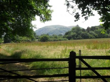
Up early for the best breakfast of the trip so far. Lots of fresh fruit and a perfectly cooked ‘English’. Once again the inn came up trumps and I obtained a lift back to Alfrick. Walking through fields brought me to The Knapp & Papermill gorge on the Leigh Brook [ a nature reserve.] Somebody had been before me and amazingly left all the gates open!!!  Met them on their way back, three youngsters, and they seemed unconcerned about their slovenly habits.  No wonder land owners get ruffled.

More complicated fields and diversions past posh houses brought me out near a pub on the roadside. Fairly average place, but a pint of lemonade never did anybody any harm in this heat. Leaving, after a brief stop, the Malvern Hills became more prominent and needed to be climbed.

Ever since I viewed Ken Russell’s Monitor documentary on Elgar in 1962 depicting a young Elgar riding a white pony over the Malvern Hills accompanied by his music I’ve wanted to walk these hills. Certainly picked a very hot day to do so!          Several springs lie below the hills and these gave rise to  Malvern Bottled Water. Famous for having nothing in it!!    I passed the Beauchamp Fountain whose daily out put was 10,000 gallons.

I was surprised how steep the ascent onto the Malverns was from the north end. Toiled up alongside various groups of young people, the girls naturally in high heels. These hills are Pre-Cambrian resistant volcanic rock,  granite, with dolerite intrusions visible as crags on the hillsides. There has been extensive quarrying on the lower flanks. Eventually I reached Worcester Beacon the highest point at 425m. There is a toposcope [erected 1897] highlighting the visible points from the summit. Apparently this was ‘stolen’ in 2002 but has since been replaced.

Sat looking at the rather hazy views with the temperature in the 30s. Swifts were flying low. Sounds drifted up from Malvern town below, the colleges and churches clearly visible.

The ridge southwards was a lovely stroll…

Looking south.

…and I was soon down at The Wyche cutting, the original low route through the hills before the railway tunneled below. The tunnel opened up the Colwall area for many businesses, including brick works and a bottling plant. The latter now handles 12million litres of Malvern Spring water annually. One of the ventilation towers for the railway tunnel stands by the path and apparently is home to a large colony of Horseshoe Bats. Loss of concentration at the end of a very hot and tiring day meant I added to my distance by wandering on the wrong paths in parkland.

Looking back to Worcester Beacon.

Eventually found my cosy little B&B in the village, cold shower and lots of fluids.    Went out for supper to the pub later, few people in – just too hot to bother.

THE GEOPARK WAY. Great Witley to Alfrick.

View back to Abberley church.

Frid. 12th July.

The limestone ridge was soon gained before the sun really got going. There were views back to Abberley with the church tower prominent. The ridge was mainly tree covered and I was glad of the shade. Buzzards seem very common in this part of the country and I spent some time trying to get a photo of their beautiful soaring flight. However the calm and stillness experienced on the ridge that morning watching them wheel around is difficult to describe. Nobody else about as usual.

I’ve had the same frustration with my photographic attempts of the numerous butterflies in the fields, and I must brush up my identification skills. Flowers were easier prey for me as shown by this magnificent wild rose…

‘Bull in field’ became a reality further on requiring a detour on the other side of the hedge.

I skirted Woodbury Limestone Quarry and could hear Peregrines. The vertical strata of the rock showed well and there was a large deep pool in the quarry floor. There have been several drownings this week in the area with youths cooling off in these dangerous waters.

Another shady ridge brought me down to the River Teme which was sluggish this morning at the site of an old mill. Pleasant change to be near water again although the Horse Flies were a pest.

Arrived in the village of Martley to find the Crown Inn closed but luckily the little Mace convenience store sold all I needed for dehydration and a picnic lunch in the shade. The local church of St. Paul dates from the12th century and was built from the local sandstones. Apparently the tower has a set of 6 bells from 1673 – the oldest complete peal in the country. Inside has lovely timber work and some faded medieval plaster wall paintings, some depicting animals familiar to the country folk. All this was explained by an electronic ‘listening post’ – excellent.

A rather pointless climb back up onto the ridge brought me to Ankerdine Hill, from here there were no views because of tree growth despite being shown on the OS as an all round viewpoint. Felt a bit frustrated with all the climbing to no avail in this heat. Soon down to Knightwick where my B&B was situated, The Talbot Inn. Arrived early and as tomorrow would be a long day decided to do a few more miles today. The kindly bar lady at the inn gave me a lift to the next village of Alfrick and I walked back through orchards and hop fields by the river Teme, to arrive in time to buy her a drink before she went off duty. Cheers Sue.

Hop plants.

There are some expensive looking houses in the area, some even being converted hop kilns. Quintessentially old English.

 A lovely evening was passed outside over a light supper and the beers [THIS, THAT and T’OTHER] produced at the Talbot Inn from the local hops.

The Talbot Inn.

THE GEOPARK WAY. Bewdley to Great Witley.

The River Severn.

Thur. 11th July.

Looking to make life easier in this heat I decided to use The Severn Way from Bewdley to Stourport instead of the more tortuous Geopark. At least it being a named trail along the river there should be no problem with overgrown paths.

The waymarking on the Geopark Way  has been good to sporadic and a careful reading of the guide along with the OS maps is needed to follow it easily. The logo on the waymarks is a stylised image of a trilobite fossil from the Silurian Period, I never found one [a fossil that is] on the way.

A quiet stroll along the river, with few people about but lots of semi residential caravan parks in close proximity. This area is the escape route from the midlands. Green woodpeckers were flying from tree to tree. Soon I was walking into Stourport where The Staffordshire and Worcester Canal  [1771 – James Brindle] appears joining the Mersey and the Trent to the Severn. This canal and its extensive basins established Stourport as a major port, making Bewdley redundant. Sarsons Vinegar was one of the industries benefiting from it. It was fascinating to wander around the old basins with their present day boats and the associated warehouses all connected by a complicated series of locks. Genuine industrial heritage.

But why, oh, why Stourport have you allowed one of the basins in the middle of all this heritage to be used as Treasure Island Pleasure Park? I’m not snobbish about these places but surely there was somewhere else to locate it!!!

Made a hurried retreat across the river to escape [what must it be like in the school holidays] Along the river bank you come across Redstone Rock, a soft sandstone cliff that has been excavated in the past, 16th century, to create an hermitage. Unfortunately you can’t gain access to the interior now.

Redstone hermitage.

Moving away from the river I seemed to go astray but found myself on a minor road that led to Larford Lake, a popular commercial fishery which looked very attractive with its water lily beds. Not bad for 10 quid a day.

I was getting hot and tired by now and glad to reach and follow the river bank to arrive at The Hampstall Inn at The Burt. A pleasant place on the riverside. Further on the route followed a side stream, Dick’s Brook, hard to believe this had once been navigable, as a canal with locks, to an iron furnace and forge.

Dick’s Brook.

Continuing in the same line I arrived at the retreat of Glasshampton Monastery which was originally the stables of the manor which was burnt down twice. Careless!

Glasshampton monastery.

Across the hillside could be seen the church of St. Peter’s at Astley. This proved to be of great interest with a lovely sandstone exterior and an interior with many religious relics.

Tombs of the Blounts.

Interesting barrier at the church gate – didn’t have time to wait till evening.

From Astley steady climbing in the heat of the afternoon gained the ridge of Abberley Hill at the limestone quarry of Shavers End. It was not possible to see directly into this quarry and as there seemed to be some police activity in the area I continued on along the way below the ridge. I was climbing up and down in trees most of the way so views were limited and orientation difficult. I knew I had to leave the ridge before the end to reach my, off route, evening destination. With a maize of paths to choose from I was lucky to choose one that descended out of the woods into open fields. From on high I got my first glimpse of the Malvern Hills and also the continuation of today’s ridge for the morning.

Distant Malverns.

The fields luckily led directly down to the road at my hotel – The Hundred House. This place was rather behind the times but my room was comfy, the food good and the staff friendly. The hotel needs some care and attention -but that costs money. The hotel name dates from centuries ago when  the building was used as the collecting house for the tithes gathered from 100 districts in the county.

In the bar at night got chatting to a visiting worker who turned out to have a house in the Lot Valley in France from which I’d just returned. [see post]
Remarkably we knew a lot of mutual friends from the area and share a love of our favourite café in Duravel.  Small world!

The Hundred House.

A long but interesting day.

THE GEOPARK WAY. Highley to Bewdley.

Wed. 10th July.

Shared a breakfast table with overnighting fishermen who were not catching anything because of the heat. They were taking the day off and having a trip on The Severn Valley steam train, for a while I even contemplated the day’s journey using the same means. Made of stronger [read stupider] character I set off with large reserves of water, steeply, up past the authentic looking Highley station, that takes those of a certain age back in time! Note the platform ticket machine.

Highley station Severn Valley Railway.

On through the site of the old Highley coal mines. This area has been expertly transformed into a local country park with several reminders of its heritage.

The morning was getting hotter by the minute, so I was glad of a shady walk following an old colliery railway along a valley. The whole area is scattered with industrial relics. Stopped to talk to a gentleman walking in the opposite direction, it turned out he had been a coal miner in the Highley pits. Fascinating encounter, he had left the mines in 1962 as the coal dust was getting on his lungs. He remembered following seams of coal only for them to disappear in a fault. He described going down the mines on the Alveley site [east] and coming under the Severn into the Highley [west] system. He also remembered several deaths due to tunnel collapses. He was 74 and most interested in the detailed mining information in my guide book.      The mines closed in 1969.

Came out onto the road near Ray’s Farm attraction, which offered refreshments. Enjoyed a coffee whilst watching the local school kids coming close to nature – a few goats and chickens.

Today’s walk was quite long and tortuous, so I decided to save a couple of miles on a shortcut down a lane and then through fields. Things didn’t work out too well as the footpaths were overgrown and almost impassable, also I got lost and ended up bushwhacking and cursing across fields and fences to escape. Shortcuts don’t work! Not many people come this way. Not a good plan on these hot and sweaty days…

…lost…

… no wonder my hayfever was playing up!

Eventually sorted myself out and came onto the road right next to the Eagle and Serpent pub. Not a name I’d come across before.

Not a very inspiring pub but a half of beer and a pint of lemonade were to become the norm on this overheated trip. There does seem to be an awful lot of local breweries producing decent beers in this area – see later re. hop fields.

More wading through crops [actually quiet a lot] but through beautiful countryside…

… brought me into The Wyre Forest.

This turned out to be one of the most memorable sections of the walk. This is  a great recreational area. It served as a royal hunting ground in medieval times, then its timbers were valued by the ship builders. In the 17 -18th centuries the wood provided fuel for the local iron forges as well as besom and basket making. It is one of the most important ancient woodlands in the country. I loved the variety of trees.

A highlight was walking along the Dowles Brook – I spotted kingfishers, dippers, herons, wagtails and woodpeckers along with buzzards and red kites above. Managed a picture of the Dipper but what  chance the Kingfisher?

Dipper mid-stream.

Further along was an old semi-preserved flour mill, apparently there were previously several along this stretch.

The afternoon wore on in oppressive heat, I joined the River Seven again for the last mile into Bewdley. This stretch of path coincided with The Worcester Way and I could hear the whistles from the steam trains on the other bank. This attractive town on the banks of the river was once an important port and there are many fine Georgian buildings. Today it was overrun with tourists enjoying the fine weather.

I enjoyed a pleasant old fashioned friendly B&B up in the old town. [Bank House]

An interesting way to advertise the ales of the local brewery

THE GEOPARK WAY. Bridgnorth to Highley.

The Geopark Way is a semi-waymarked 109 mile walk through the heart of the Abberley and Malvern hills, from Bridgnorth in the north to Gloucester in the south. The guide book has been written not only to allow you to follow the way but also to explain in detail the geology of 700 million years that you pass over. So there are Sandstone, Limestone , Volcanic and the Metamorphic rocks.  Geology lesson over.

Tues 9th July.

The bus from Wolverhampton to Bridgnorth was packed with concessionary travel carded trippers. Local knowledge gained from my fellow passenger allowed me to alight from the bus at the top of the Medieval town. First stop, the castle remains …

The keep leans at an unlikely 15 degrees. behind is a church designed by Thomas Telford in 1792. There is a confusion of steps leading down to the lower town on the Severn or you could take the only inland funicular railway.

Found a great little cafe for a brew and a light lunch,  Olive’s Cafe by the the bridge over the Severn. A pleasant alternative to the organic cafes and wine bars  prevalent all around. Olive was quiet chatty and informative. Every one around here seems to have a friendly Brummy accent – lovely.

The walking started seriously as the heat of the afternoon built up, this was to be the pattern for the next week’s heat wave.  Mainly dog walkers and the occasional fisherman encounted on this stretch of the River Severn.

  Coming away from the river and into the woodland of Dudmaston Estate was a delight. Here  because of enlightened planting a hundred years ago there is a wonderful mix of trees now manged by the NT.

 Particularly impressive are the ancient chestnuts.

 Whatever the tree I was glad of the shade.   Arriving at Dudmaston Hall I realized I’d forgotten my NT card so couldn’t gain entry to the gardens and more importantly the cafe. Had to make do with a bottle of ‘Dandelion and Burdock’ purchased from the kiosk. Very refreshing – as many of my drink stops prove in this hottest week of the year.

A  walk along The Long Covert brings one to Hampton Loade  [ferry] where the foot ferry doesn’t seem to be in operation.

From here I climbed up the sandstone ridge to the village of Alveley and the friendly  Three Horse Shoe pub for further refreshment. This area is the site of extensive coal mining in the 20th century. The path I followed down to the river was the line of the coal tramway to link up with the railway on the north side of the Severn. All day I could hear the whistling steam trains on the preserved Severn Valley Railway but I never coincided for a picture. Likewise I could hear deer in the forests but never saw any. A delightful path led along the river to emerge at the Ship Inn, my accommodation for the night.

The Ship Inn.

In the past this Inn was always popular with coalminers and day trippers from Birmingham. Now it is a destination for the well healed and the local fishermen. It proved to be an excellent overnight stop.

LONGRIDGE FELL CLIMBING/BOULDERING.

Its getting hotter by the day – up to 25º C here today. Our original plan was to go bouldering up in Croasdale but somehow the heat yesterday drained us. So plan B, with no walking uphill, sounded good to me. A tour of the bouldering venues on Longridge Fell with Robin, who is aiming to produce a bouldering guide to Lancashire – a big shout. This is my home ground and I was happy to go to all the esoteric crags that I’ve been playing on since time – since some time anyway.

First stop was Kemple End at the far end of Longridge Fell. Some classy little routes here and a good amount of bouldering. It was a little too hot in the morning sunshine. The young fit Robin [all things are relative] soon dispatched  all the problems at the left hand end. He then went on to climb [I’d call it a jump, but then I’m jealous] a new eliminate ?V5/6. Impressive.

going…

going…

… missed.

My low level crimpy and strenuous  traverse, Lowest Earth [there is a Tolkien theme here, he spent a lot of time down the road at Stoneyhurst College] proved more difficult than I previously remembered, maybe the grading is wrong, or it was too hot.
We had a look at possibilities on the steep, impressive Hodder Buttress across the quarry floor but everything seemed highball on this sweaty day. Onwards into Finlandia Quarry across the road to look at bouldering possibilities, to be honest they are limited. Some good micro routes though.  Called in at another obscure graffiti covered buttress in the forest which I’d climbed on years ago, but it didn’t look so good today. Would need re-cleaning and for what?

Our next port of call was down the road where I’d previously dismissed a quarry  above  a pond. But Robin knew better and had done his homework on a secret, secluded crag. Straight from the walk in this looked impressive from a bouldering point of view. How come I’ve missed this one, my reputation as a Longridge Fell connoisseur has bottomed out.

Despite the hot sweaty conditions we set about gardening the unclimbed crag and Robin was soon able to demonstrate his abilities on the lower parts. We will have to wait for the other areas to dry and be brushed clean. Watch this space.

Soon back at home to watch Andy Murray’s remarkable victory at Wimbledon.  Historic.

LE LOT – FRANÇAIS MISCELLANIA

To tie up a few loose ends, I’m adding this post.

As I mentioned the weather was starting to improve just as we were going to leave!  On one of the evenings the ‘Supermoon’ appeared above the hills, giving a spectacular sight. So much so I forgot to fetch my camera.

“The moon reached its closest point in its orbit this weekend, June 23rd, during a full moon, giving rise to the “supermoon,” appearing 30 percent brighter and 14 percent larger than a typical full moon. While the supermoon is mythically associated with werewolves and strange natural phenomena, really it’s just a good reason to gaze skyward. If you missed it, the next one will pop up in August 2014.”

Maybe it was the effect of the moon but I was awake very early the next morning and was lucky to see a small flock of Hoopoes on the boules court in the garden. They seem to be regular visitors this year.

Below is my poor attempt to photo them……..

The other regular wild life are the deer in the woods and sometimes they come into the garden for fallen fruit. Again another poor photo…….

The wild boar are more seclusive – but they are out there.

Within easy walking or cycling distance of the house is a most beautiful courtyarded house which has recently been resurrected as a café, Le Caillau. This proved very popular this trip as an afternoon refuge for coffee and cake.

Le Caillau courtyard.

What a great ambiance. If only the guy would smile a bit more!

The house has a good example of a pigeonnier tower. This was traditionally used to house pigeons as a food source and also to collect their droppings as a fertiliser. These structures are common place throughout the Lot area.

To revert back to our friend from Martignac  he is an excellent bread maker and appeared one evening with this magnificent offering…

The Breadman.

So we had to reciprocate and arranged an evening’s dining at a local restaurant. Unfortunately we chose the night when the electric storms were at their worst and the power was off and on all evening. They still managed to cook us an excellent high class French dinner – ‘haute cuisine’ – elaborate preparation and presentation served in small and numerous courses and accompanied by fine wine. You have to experience this fine hospitality at least once on any trip.

All at a price! I still feel that the lunch menu at the Duravel cafe gave a far superior culinary experience and much better value. Not to mention our own cooking at the house……

Bon appétit

    J’adore la région du Lot!         

    Jusqu’à la prochaine fois.

LE LOT – UN APERÇU DU SOLEIL.

As the week progressed the weather began to improve a little, sometimes the sun shone between showers. Managed a few short swims in the pool most afternoons and shivered myself dry. We even ate outside a couple of evenings. A friend lives in a nearby village, Martignac, where he is doing up an old house. This is an interesting place with a 12th century church well known for its painted frescoes. We were invited for coffee and to see the progress in his renovations. Whilst the others would drive up I decided, as the weather was fair, to leave earlier and walk the 12k or so.

From the house one goes on tracks through the vines passing the beautiful Château Gaudou, whose wines are available in England.

Looking back to Château Gaudou

Going over several small ridges you enter Puy-l’Évêque by a bridge over the River Lot. Here one has an impressive view of the medieval village with buildings dating back to the 13th century.  Wandering the alleyways of Puy-l’Évêque is like stepping back in history. This was once an important port on The Lot for timber, limestone and wine before the coming of the railways. In recent years the locks on the river have been restored in an attempt to make this section of The Lot navigable again. There are canoes available for hire on this stretch  – great fun gliding down the river.

Puy-l’Évêque

As I walked up into the village I realised I was way behind schedule but luckily the others passed in the car and I was able to get a lift up the hill through the village for a couple of kilometres. I was dropped off so I could follow the old lanes up into Martignac.

Further on you pass the village washhouse which has been recently renovated and provides a pleasant barbecue area.

Washhouse

As you enter the village on the edge of a field there is a very good example of a  caselle or gariotte. This is a dry stone hut once used as a shelter for shepherds in this area of France.

The village of Martignac consists of a few scattered houses [one restored wooden building was once a tobacco drying shed] surrounding the church, which has a prominent elevated position.

It is inside the church that the faded but still discernible wall paintings are the great attraction. Above the altar is the God of all the world. On one side are the Seven Heavenly Virtues and on the opposite aisle are the graphic and imaginative Seven Deadly Sins to scare the congregation!

Seven Deadly Sins.

Our friend is doing well with his home improvements but I think he is enjoying the French social life a little too much to get his house finished on schedule. Can’t blame him – it must be good living out here. Didn’t have to walk back.

LE LOT – PAS DE AMELIORATION DANS LE TEMPS.

Another couple of days passed by with damp conditions. Mike and I checked out the orienteering course in the nearby woods and caught up with the gardening. Meanwhile the ladies hit the shops – that’s a big disadvantage of the bad weather. Not able to make the most of alfresco dining at the house we went into the nearby village of Duravel for lunch at the Restaurant de la Mairie.

This traditional café caters for workmen, locals and tourists at lunchtime with it’s ‘menu du jour’ ……

The board in the window doesn’t do justice to the feast inside. A large tureen of country soup arrives with a basket of bread and a bottle of red wine. After enjoying their lovely flavours, you go up to the salad buffet for a selection of fish, meat and salads. Don’t overdo it as you have only just started. The main course is served next – often some obscure French speciality [ie gizzards] but today, a Friday,  thankfully fish, ‘filet de merlu’. By the time you have finished this another bottle of wine has appeared on the table.

The cheese board comes with a selection of local and regional cheeses. Linger over this with some more fresh bread and red wine.

Next you have to choose from the extensive sweet menu – gateaux, tartes aux fruits, crème glacé etc. Then you can relax with the strongest coffee you have ever tasted. All for 13Euro!!

The only downside today was that  I had to ride back to the house a ‘new’  bike bought at a sale. Thankfully all the lower gears worked. The lanes around here are perfect for cycling as there is so little traffic, but there are some sharp hills. There is lots of opportunity for ‘off road’ cycling in the forests and vineyards.

BEAUCOUP DE PLUIE DANS LE LOT.

I’ve been going out to The Lot Valley in France for several years in the same week of June and have always enjoyed wonderful weather. Well this year things were different, as many of my other endeavors have been, and it was dull and rainy most days. The sun bathing and swimming were off the menu but there was so much more to do. Restless the first morning – so despite the gloomy outlook I went off for a stroll up the combe behind the house intending to traverse the ridge past a communications tower in the picture below.

Communications Ridge.

Most of the other properties were shuttered up as it is still ‘pre-season’ for the French.

The next field had not been cut so there was an abundance of flowers, orchids and butterflies.

I was wet through quickly from the long grass but once up onto the ridge there are good tracks. The usual views across the valley back to the house were  disappointing and there were no buzzards circling.

Once at the base of the ridge a track winds between the wooded slopes and the vineyards all the way back to the house.  I always think how well tended the vines are in this area.

There was a new addition to the scenery this year, possibly an old Simca or a Panhard??        Where did it come from?

Soon I was back enjoying a glass of white fizz [£1 a bottle at local supermarket!] and a fresh salad. The misty afternoon was spent at  the nearby Château de Hauterive tasting their latest rose and red wines, along with the potent Eau de Vie made from their prunes. The Filhol family have owned this land for five generations. They cultivate with traditional organic methods.  The gravelly/clay soil is particularly suitable for vines. Malbec grapes form the basis of the richly coloured and tannin full Cahors wine. Nowadays Merlot grapes tone down the wine which is much improved with age.  It’s a pleasure to talk to Mr. Filhol and his two sons and we came away with enough wine for the week.

THE SANDSTONE TRAIL – off the ridge. Day 3

Hampton to Whitchurch.

Farmyard Pump.

Sun streaming through the curtains this morning and a hearty farmhouse breakfast were a good start to my last short day. Also staying at the b&b was a gentleman from Germany who was on his eighth day cycling from Lands End to John o’Groats. Of course, he spoke perfect English so we dallied over tea and toast discussing long-distance walking and cycling, their ups and downs. He was trying to keep to the smaller byways, but finding this gave him lots more climbing. This last week, whilst the weather was fine, he had been battling with a constant headwind; the cyclists’ nightmare. Seeing today’s forecast, he will probably be blown along with a strong tailwind and the rain it will bring.

Off to John o’Groats!

A stretch of field walking took me off the ridge with views south to The Wrekin and other Shropshire hills. This reminded me of a walk I did with a friend in 2005 called simply The Shropshire Peaks Walk. Those 100 miles incorporated the main summits of south Shropshire ie Titterstone Clee, Brown Clee, Wenlock Edge, Long Mynd and The Stiperstones. A beautiful area and a reminder of the good hillwalking one can access away from the traditional mountain areas.

As I mentioned previously The Sandstone Trail is well signed and waymarked with bright yellow discs. I did not have a guide book [out of print] and my old 1:50,000 OS map did not have the route highlighted. But for two days I’d not gone astray.

Things always get more complicated in lower farmland fields and maybe one becomes a bit laxer with navigation. It doesn’t help when the land you are passing through is Bickley Hall farm admirably managed by Cheshire Wildlife Trust. They have preserved some of the meres in the area to provide wild life habitats and set up marked trails through the farm to appreciate the diversity. I think it was one of the marked trails I was following towards Bar Mere when I realised I was heading East instead of South and there were no TST yellow markers. A minor diversion but it shows how easily an extra half hour is added to the day.

A happy group of schoolchildren were pond dipping across the field – what a delightful pastime – where’s my net?

Pond Dipping.

The farm also bred Hebridean Sheep and traditional Longhorn Cattle.

What a contrast at the next rather unwelcoming farm – this was the sign on the Right of Way through their yard.

The field paths abruptly finished on the tow path of the Llangollen Branch Of the Shropshire Union canal at Willeymoor Locks and inn. A waiting queue of narrow boats were going down the canal here.

My last stretch was 3miles along the canal to the outskirts of Whitchurch. I had barely begun when with a clap of thunder the heavens opened and I was subjected to a torrential downpour. All the canal boat enthusiasts seemed happy as they drifted past and the ducks were in their element.

Garden boat.

Wet ducks and camera!

Walking quickly in the downpour I soon arrived at Grindley Brook Staircase Locks but I was slowly drowning, so made a quick dash into The Horse and Jockey pub. Despite my soaking appearance I was made to feel welcome and enjoyed a pint and a chat until the rain ceased. Top marks.

Disappointingly there were no boats using the ‘staircase’ when I returned to the canal.

Grindley Brook Staircase.

A short walk brought me to the small branch canal leading to Whitchurch, I crossed to it using a ‘Van Gogh’ style bridge.

This was the end of the canal and the walk petered out in  Jubilee Park, not a very satisfactory ending, so maybe I’ll walk the route in the opposite direction next time. There is  lots more to explore on this trail which I either missed or didn’t have time for this occasion. Certainly worth another look at this great little route which I’ve thoroughly enjoyed.

End of the Line.

THE SANDSTONE TRAIL – a connoisseur’s route. Day 2.

Utkinton to Hampton.

My photos on this post have mysteriously disappeared, sorry.

The eggs at breakfast really tasted freshly laid – which of course they were. The weather was OK. In a good mood I set off wandering through potato fields towards my next objective on the sandstone ridge – Beeston Castle.

Beeston Castle.

Beeston Castle.

First I had to cross the Shropshire Union Canal and the rail link to Chester running together in the valley. I arrived at Wharton’s Lock on the canal just as a boat was passing through. Everyone having their own adventures.

Lanes took me up to the restored gate house of Beeston Castle. The castle is sited on an impressive sandstone bluff and was started in the 13th century to protect an Earldom. Apparently the view from its walls extends to eight counties, I did not test this as time was pressing and the admission fee only worth it for an extended stay – which I’m sure would be magical.

A delightful interlude through fields full of poppies followed.

On the next part of the ridge was the Victorian Gothic Peckforton Castle inspired by Beeston castle.

Peckforton Castle

Thankfully some of the estate is open for a footpath climb back through trees up onto the ridge.

A great stretch of walking brings one out onto a minor lane near Higher Burkwardsley where I had heard rumours of a good inn half a mile off route. It doesn’t take long to walk half a mile and find oneself at The Pheasant Inn.

I was intending just  having a pint of the local Weetwood Cheshire Cat blonde ale until I saw the menu – I was tempted by smoked salmon on a bed of rocket and cottage cheese  bagel. The staff were very friendly and I enjoyed my sojourn in the sunshine on their patio, with views stretching to the Liverpool cathedrals.

An afternoon of a roller coaster along the sandstone ridge lay ahead. First over Bulkeley Hill with its ancient sweet chestnuts.

…. and views eastwards to Jodrell Bank, the Pennines and Derbyshire.

Soon I was climbing again up to the highest point on The Sandstone Trail – Rawhead 746 ft / 227m,  identified by a special trig point.

On the way along the ridge there were some spectacular views of the sandstone cliffs

Apparently the sandstone from here was used in the past for scouring the stone flags in the local houses. The path went steeply downhill from here only to reascend up onto Bickerton Hill. This is owned by the National Trust and they are trying to re-establish the important heathland of heather and bilberries. To this end they are grazing with ponies to remove saplings and other vegetation.

This hill top is also the site of one of the six Iron Age Forts along the ridge. Because of the trees it is difficult to see any fortifications. I was able to get  good views back to Rawhead and Bulkeley hills before cloud and drizzle moved in from Wales.

Plunging down now through wet vegetation brought me through fields to the horse racing training complex of Manor Farm where ex-Liverpool and England soccer star Michael Owen has invested millions. Looks a very impressive place from the periphery, which is as close as one can get, some rights of way having been diverted to protect the rich and famous.

A few small lanes took me to Hampton House my accommodation for the night. Another excellent b&b run by retired farmers, [had to get out of dairy farming because of low profit margins]  Whatever their profit margins are now this was one of the better b&b s I’ve ever stayed in. Just like going home to your parents, if you know what I mean.

http://www.hamptonhousefarm.co.uk  to give them a plug.

Another eventful day’s walking.

THE SANDSTONE TRAIL – a hidden gem. Day1.

The Sandstone Trail is a 34mile/55K walk along a ridge of sandstone from Frodsham to Whitchurch. That statement really doesn’t do this distance walk justice. I have just returned from two and a half days glorious and varied walking – one of the best short routes I’ve experienced in England.

Unfortunately my photos on this post have mysteriously disappeared.

There is good transport to either end; there are excellent friendly pubs, cafes and b&bs along the way; the waymarking faultless; the varied scenery and walking underfoot superb.  Used all my hyperbole in one sentence!  Just go and see for yourself.

Frodsham to Utkinton.

After two weeks of dry sunny weather the forecast was not good and as my train arrived in Frodsham the rain had just stopped. I’d traveled via Warrington where I was given a chocolate bar to warn of service disruptions in the near future. A unique gesture – which I’ve eaten.

I knew I was in the right place when I alighted from the train ….

….and wandering through the town came across this unusual phone/stamp/posting box.

The start of the walk was soon found outside The Bear’s Paw inn

Dull weather accompanied me up onto a morning’s invigorating 5mile walk along the sandstone ridge. Notice the distinctive yellow footprint waymark logo. This wooded escarpment is composed of  sandstone with several lines of rusty red outcrop cliffs giving  views over the Wirral on a good day.


Helsby and the Wirral.

Coming off the escarpment, I was pleasantly surprised to come across a café at Manley. This is Stonehouse Farm, [b&b] which has been in the same family for 6 generations. As all the seating was outside, I was glad that it was dry, even if a little chilly. Soup and coffee were great, I passed on the scones [see later].

This was followed by  different walking through the vast Delamere Forest. There is a maze of tracks in here, all well signed for walkers and cyclists. The tree population is varied with mixed conifer and deciduous  and areas of undrained ‘meres’ giving  further habitat diversity.

Good walking took me back up onto the ridge continuation for three or four miles.

Came out into more rural farming land with the distinctive metal kissing gates installed on the trail  —–

After you.

Couldn’t help but come across another wayside café with friendly staff. Felt I had to support them with a minor purchase of tea and scones. They were telling me of being cut off for a week in the snow storms at the end of April, the café can only be reached by very minor steep roads. Nevertheless, today it had a steady  stream of regulars. What would the British countryside be without these simple institutions? Happy to give them a plug.

By now the day had brightened up and there was some warmth from the afternoon sun making the last 4 miles or so a delight, with views to the Clwydian range of hills in North Wales. A feature of the whole walk was the ever present crying of Buzzards circling overhead. Hopefully this gives some indication of a healthy population of these majestic birds.

The distant Clwydian Hills.

My accommodation for the night was a beautiful old Cheshire farmhouse, just off route, and well used by walkers.

Neighbouring properties were more along the lines of those seen in Cheshire Life and costing the earth. As a measure of the wealth I noticed a Lamborghini, a Ferrari and a Porsche all in one drive, I kid you not.

My more humble working farm  turned out to be an excellent B&B, and I was well looked after. Didn’t need to go out at night as I still had my lunch left over — made redundant with the day’s two café stops!

Yew Tree Farm

Very relaxing rural evening after a full and interesting first day.        http://www.yewtreebb.com

INGLORIOUS INGLEBOROUGH.

Driving over from Lancashire in the sunshine held promise of a glorious day like the preceding few. Alas on crossing the border into Yorkshire greyness reigned and did so for the rest of the day. Good to meet up with old friends for today’s walk. We  arrived in Austwick at the same time thus avoiding, on all sides, the usual derision as to our time of rising or navigational skills to the chosen venue. It was presumed we had one map between the four of us, compasses weren’t mentioned. We were soon into our stride out of the delightful village of Austwick…

Last of the summer wine!!

…past lots of characterful stone cottages.

It had been very warm this last week –

Our first objective was to visit the hillside which is home to the famous Norber Erratics. These are sandstone boulders and were transported  by glaciers,  15000 years ago, from cliffs 1km away to the north in Crummackdale and were deposited  on Carboniferous limestone when the ice melted. Some of the larger erratics have protected the limestone beneath them as upstanding  pedestals of limestone. On the hillside are  a mass of such boulders but our ‘Team Geologist’ was unable to find the the most photogenic. We were in luck as the local SARDA were running a practice dog rescue on the hillside and their leader, knowing the area well, was able to point us in the right direction and assured us that if we became lost or cragfast the dogs would find us.

One of the best.

By now the morning was passing rapidly and we had various problems with navigating through the fields we had mistakenly become enclosed in without damaging any farmers stone walls. We realised our only map was woefully out of date by about 40 years.

 Once on the correct bridle way we made better progress until it started going downhill in the wrong direction, a heated discussion resulted in a rather uncoordinated attack on the limestone pavement above us. This off-piste route did however reward us with a fine cluster of purple orchids.

Soon back onto  one of the main thoroughfares, from Sulber Nick up onto Ingleborough, and we were made aware of the vast amounts of footfall that these paths take. Masses of Three Peak walkers started to stagger down past us. Good luck to their chosen charities. The path was ‘protected’ by stretches of stone flagging  and the less durable boarding.

Even in our small group  competitive hurdling appeared –

  — as we progressed towards the summit.

This was Ingleborough, 724m or 2573 ‘Wainwright’ ft, poor views, late lunch in a cold wind and hoards of people enjoying the experience on their smart phones! The top was flatter and more confusing than I previously remember.

Hint — a compass would be helpful in all but the best of visibility.                       Incidentally where does the ‘borough’ originate from?  It usually denotes a town.           We careered over Little Ingleborough and down to the unmistakable Gaping Gill.

This is probably one of the best known British potholes, the awesome surface rift leads to a vertical shaft of 340ft and a gigantic cathedral like chamber. For the full experience try to go down on one of the organised ‘cave rescue’ events on a winched chair in May or August bank holiday breaks.

Onwards now and into the dry valley of Trow Gill, which today was busy with climbers ascending the vertical limestone walls. The gorge has been transformed into a sports climbing venue — i.e. bolted, and is proving very popular.

A few miles, of I must say, rather tedious stony bridleways –

– brought us back to Austwick and the welcoming  Game Cock Inn.

The Game Cock.

Over a pint we solved  the in or out of Europe question, we considered the benefits of Pacer Poles and we worried about male breast cancer, I can’t remember why.
Till we meet again.

WHAT GREAT WEATHER.

Just a quick post to celebrate the lovely June weather.

Dry and sunny with the temperature in the 20’s. Somewhat incapacitated from active  climbing – I don’t even want to know where my mates have been out cragging today. After catching up with the garden, I couldn’t resist a late afternoon look at Craig y Longridge. Quite a few out bouldering.  I have been waiting for the base of the far ‘Pit Area’ to dry out as I have a trio of tasty traverses there. Almost possible today, but one or two stubborn damp patches, give it a couple more days.

Pit Area when dry. 2011

So decided to have a walk up Longridge Fell in the evening sunshine. The usual circuit from the parking at Cardwell House up to the trig point and then round the forest tracks to give a pleasant 5 miles. The Vale of Chipping was looking very green and verdant. I have to appreciate what  a beautiful area is on my doorstep.

Chipping Vale.

Noticed lots of cars parked up on the roadside at Cardwell Quarry, so wandered in to find the Preston Mountaineering Club enjoying the sunny evening. Soloed a few routes and was entertained by the assembled climbers. Friendly lot as you would expect.

A busy Cardwell!

Enjoyed a lovely sunset later.

THE SPEYSIDE WAY. Fochabers – Buckie.

Our last day.

The weather has changed again and this morning there is a bitter north wind with heavy showers forecast. We walk down to the banks of the Spey and then along under a new bypass – which explains why the town was quiet last night. Continuing through mixed woodlands with gorse and broom in flower made for pleasant progress. There were glimpses of the river in full flow with the persistent fly fishermen. You never see a woman participating in this sport.

Heavy sleety showers passed quickly through and eventually we came out at the shingly mouth of the Spey.

In 1768 a salmon fishing station was built here. The large Tugnet Ice House [1830] still remains. Only a third shows above ground level. Ice was gathered in winter  and stored in the ice house to keep the salmon  fresh. The buildings have been converted to be used as The Moray Firth wildlife and dolphin centre.

We didn’t have time for any dolphin watching and the next storm was blowing in so we headed to the  Spey Bay golf links and their welcoming clubhouse/cafe. The near by hotel has closed but we were able to enjoy a coffee here and listen to the banter of the golfers who were not in a rush to set forth in the rain and wind.

Braving the weather we continued, the Speyside Way now taking the same route as the Moray Coast Trail. For three miles we were in the sheltered woods just inland of the links so had no view of the sea. The last of those damn metal squeeze traps was passed.

We emerged at the small harbour village of Portgordon looking rather bleak in today’s weather.

Amazingly, in this run down place we came across the small Lennox Inn and enjoyed a pint in the tiny cosy bar. The landlady was only too pleased to chat, took us back a few decades in time.

Traditional hospitality.

A little further along the coast we had a view of seals basking on a rock just offshore.

Maybe because of the beer we managed  to loose our way in the gorse bushes around the next golf course but eventually arrived at the  harbour of Buckpool which was the end [or beginning] of The Speyside Way.

The End.

This seemed a little unsatisfactory leaving us to wander through streets for another mile into the unpretentious town centre of Buckie. Would have been preferable to continue on the coast to Buckie harbour and then up to the centre.

All that remained was to catch the bus into Inverness for the night and the traditional end of walk curry. Oh and the long train journey home the next day.

So I would highly recommend The Speyside Way. It has given us six days varied walking through grand scenery. There were lots of interesting diversions along the way, we met some lovely friendly people and enjoyed the wildlife. It gave me a good chance to catch up with my old mate and we probably both put on a few extra pounds! I look forward to our next annual hike.

Take a look at the official web site for all the information you need – http://www.speysideway.org

THE SPEYSIDE WAY. Craigellachie – Fochabers.

The day was much brighter with some blue sky showing through the previous grey clag. A short stretch of old railway bridge over the River Fiddich and an old inn on its banks.

By all accounts this is  an unique place steeped in the past, wish we had had the foresight to visit last night before supper.

We were now walking on a minor road into the Ben Aigan forest. We slowly were gaining height in a beautiful  woodland setting.

The gradient was so gentle that we reached the highest point on the Way before we even realised, having expected a tough ascent. There were views down the Spey northwards  to road and rail bridges at Boat of Brig, we would arrive here an hour later. The Moray Firth was also visible and can just be made out at the top of the photo if you click to enlarge. Lots of walkers were met coming the other way, the characteristic midway rush hour.

The route was very undulating from here on and we didn’t see a soul on this section of minor road. At one high point there were rather restricted views back south to the snowy Grampians from where we had come.

The gorse was in full bloom on this stretch.

We diverted to a high view point over the River Spey. There were men stood in the river up to their thighs with a stick and line. Apparently they pay up to a thousand pounds a day for this! And I thought long distance walkers were verging on madness.

We eventually arrived in the sturdy, granite constructed, traditional village of Fochabers.

A no nonsense B&B and a no nonsense fish and chip shop were our delight followed by a couple of pints in a no nonsense inn.

Fochabers is the home of the  Baxters food company, of the Royal Game Soup fame. As I was walking with a Baxter I had hoped to get a photo of him outside the factory. Unfortunately it was well off route!

THE SPEYSIDE WAY. Ballindalloch – Craigellachie.

By having an early breakfast we were able to book onto the first tour of the morning in the nearby Cragganmore Distillery. We were the only two so had a private trip with guide. This is only a small outfit and we got to see, and smell, all of the processes at close hand. The distillery was set up in 1869 to take advantage of the Craggan Burn and the nearby railway. Cragganmore Single Malt is one of the most complex Speyside Malts.  The distillery’s unique flat topped spirit stills and the slow condensation in traditional worm tubs, promotes Cragganmore’s complexity. The whisky is stored in either  Bourbon casks imported from the states or Sherry/Port casks – each giving a different taste. There were vast bonded warehouse spaces filled with ageing casks, quite a sight.

The whole process from mash to spirit is now computerised and can be virtually run by one man from a central console! At the end of the tour we got to sample two of their single malts and as we were the only ones a couple of other malts as well.           Unusual to start a days walking fuelled by whisky.

The day continued with a whisky theme as the walk followed the Speyside railway for 10miles past several other distilleries and their abandoned halts.  Speyside  has the greatest number of distilleries of any whisky producing area.  First we crossed the Spey itself on the iron girdered railway bridge.

At the far end we were awarded the sight of  a red squirrel in a nearby tree – giving a good photo opportunity. We in fact saw red squirrels most days of the walk, so hopefully they are thriving up here.

Easy walking gave us fast progress with the river close at hand. Several other way walkers were encountered and the abandoned line was popular with cyclists. Abandoned railways can often become monotonous to walk along but somehow today had plenty of interest.

Eventually we arrived in the pleasant small  town of Aberlour for afternoon coffee and then the last couple of miles along the Spey to the even smaller Craigellachie. This consists of a distillery, a handful of houses and two hotels.  We were staying in The Highlander, the more modest of the two. Greeted by a Chinese girl with blue hair! Also serving on were a Thai and a Dutch girl. What’s going on? Not a Scot’s accent in the place, which is renowned for its collection of malts in the bar. They have over 400 different malts, which is nothing compared to the hotel across the road which has 750! The Whisky ‘menu’ was a volume in itself, I restricted myself to sampling the malts from the local distillery in the village. Everyone in the bar were enjoying themselves and all seemed very knowledgeable about the whisky, particularly the large number of German visitors.

Another varied day.

THE SPEYSIDE WAY. Cromdale – Ballindalloch.

Again a dull morning but enlivened by a great breakfast served by the lad who is a highland marathon champion. I bet he has porridge. Off again along the railway and soon into a gull colony where we attacked by the BIRDS.

Black Headed Gulls. No damage.

For a couple of miles it was easy going on the old track but then suddenly we were faced with steep ascents into the forest. With the mist down the woods took on an aerie atmosphere.

The undulating route took us out of the woods and up onto a ridge which would have given us views back to the Cairngorms if it had been clear. We met a man going in the opposite direction who was 77 and recovering from a hip replacement – impressive.    The ground was rather difficult being boggy and bouldery  so we made slow progress.

The days walk was characterized by the style of stile on route. A sort of squeeze stile updated into a springing metal trap. Must have passed through a hundred of these today.

We were often fenced in by barbed wire, to separate us from the cattle, so it was not a good walking experience.

The woods we travelled through were heavily encrusted with lichens, which gave an added aspect to the scenery.

Eventually we dropped down to the old railway  by the Spey for the last couple of miles to our Ballindalloch B&B – Cragganmore House. This large house had been the property of the founder of the Distillery back in the 1860s. The present owners have furnished in a period style making it popular with visiting tourists.

We thought the £32 evening meal a little pricey so survived on cup-a-soups and biscuits in our room. Very peaceful night in the middle of nowhere.

THE SPEYSIDE WAY. Nethy Bridge – Cromdale.

It rained all night. The superb breakfast was enhanced by the tales from the three crazy bird watchers . The whole region is busy with twitchers hoping to see the Osprey and the Capercaillie.  Suitably fortified we wandered down beside the River Nethy to join the old Speyside Railway.

This section of the railway has not been reopened, although the enthusiasts would like to extend the steam route to Grantown. The railway originally started in 1863 and linked Aviemore to Forres.  This line was heavily used by the whisky distilleries that set up beside it. Beeching closed the passenger line in 1965. Goods continued till 1968. The well graded route gives good walking and we were soon on the outskirts of Grantown crossing the Spey on an old bridge.

The morning had been rather dull but as we walked up into town the rain started, fortunately we soon reached the welcoming Chaplin café.

Too cold for ice cream but we had lovely toasties and pots of tea whilst we dried out. Forcing ourselves to leave we braved the afternoon rain with a superb walk through the Anagach Woods. These woods are home to the Capercaillie but of course we never saw any.

Crossing the Spey by a metal bridge we see an enthusiastic fisherman casting in the river, no doubt at great expense.

Past the old picturesque Cromdale station …..

……and soon we were in the unpretentious but friendly Haugh Inn in Cromdale. What a great little hotel. Good room, good food, friendly staff from the Wirral and a fine selection of beers and whisky. Whilst Mel sampled the Windswept 6% Dark beer from a new micro brewery I started on the single malts from the Spey we had walked so far.