Tag Archives: Pennines

SOUTH PENNINE RING – Sowerby Bridge to Huddersfield.

As I stepped off the train in Sowerby Bridge I was face to face with an old climbing friend, Sandy, whom I’d not seen for a few years. A brief chat before the doors closed and he was on his way to Leeds. One of life’s unusual coincidences.

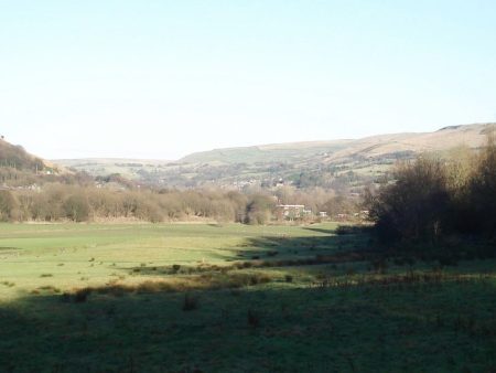
My walking trip around the South Pennine Ring was interrupted last week with the arctic weather which cut off this area.

From Sowerby’s main street the last section of the Rochdale Canal is reached and a couple of locks go down into the town’s basin. This morning I was pleased to see a barge coming up, a couple had taken 6 months leave to follow an ambitious circuit of the country’s canals. In the historic basin itself little moved. This was the beginning of a short section on The Calder and Hebble Navigation which travels to Wakefield and is part canal and part River Calder, hence the name ‘Navigation’. It was engineered by a renowned 18th century canal builder, John Smeaton. The work started in 1759 and the canal opened in 1764, much earlier than the others.

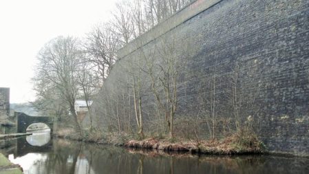
Walking out of town I was surprised by the amount of house building on low ground between the canal and the river- watch this space in a few wet winters’ time!  A long level towpath, popular with walkers and cyclists, brought me to Salter Hebble locks where previously a branch ambitiously climbed up to Halifax. Lots of interesting canal architecture on display as I dropped under busy road intersections to a calmer stretch. An electric guillotine lock lies at the bottom.  Down here are the usual grouping of canal, river, rail and road. There are some impressive arched bridges constructed by the railway companies.  More industrial heritage followed, some ruinous others renovated and reinvented. Balconies on mills mean apartments. I lost my way a bit in Elland where roads have blocked the towpath which swaps sides, a short diversion over a bridge and down Gas Works Lane had me sorted. Elland was noted for the production of Gannex Macs, a favourite of Sir Harold Wilson. More of him later.  High heeled office staff from canalside offices were walking to lunch, I was heading to Brighouse, The river was in close proximity ready to join in the action.

Two tall towers, disused wheat silos of Sugden’s Flour Mill, greet you at Brighouse. They are now unusual climbing walls.  My excellent lunch was taken at the busy No 43 cafe, canals get you to the heart of these Yorkshire industrial towns. The canal basin is alongside shops and car parks. Unfortunately soon my way was blocked and I took to the desert of an industrial estate, is this what keeps Brighouse alive?  Interspersed with the metal sheds were remnants of workers back to back cottages.Where do the workers live now, not in the luxury mill apartment conversions I bet.

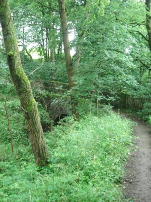
Canal trust workers were busy tree cutting and lock mending but I squeezed past to a surprisingly rural section. Up to now the towpath had been a metalled walkway but from here on after the M62 was a muddy path, soon to get worse. Lancashire and Yorkshire Railway markers remind one that as the canals lost their influence the railways took over. The River Calder joined the canal for several sections. The path alongside became dangerous and I had doubts that I could reach Cooper Bridge where the Calder goes off to Wakefield and I would join the Huddersfield Broad Canal heading back up west. Opened in 1776 it was known as Sir John Ramsden’s Canal, a wealthy Huddersfield landowner at the time. Coal was carried from  East Yorkshire to power stations until 1953. A friendly man lives in the lock-keepers cottage at the start of the canal.

The canal immediately starts climbing. Industry reappeared, its never been far away in these valleys, with a mixture of derelict structures and modern sheds.  The light was fading as I entered Huddersfield, dubious characters and graffiti appeared so I cut short the day at the elaborately engineered  Locomotive Lift Bridge, a vertical lifting bridge from 1865 now under electric operation, and climbed past the seven storey Brierley mill to the station for a quick trip back to Manchester. Things will look better in the morning.


A long walk and hence a long post – two canals in one day.


*****


SOUTH PENNINE RING – Todmorden to Sowerby Bridge.

When I was a youngster I would travel alone across the Pennines by rail to stay with an Aunt and Uncle in Manchester. A whole new world would appear to me as the steam train travelled down Calderdale, I have a long lasting vision of steep sided enclosing valleys, running streams and tall weaving houses with mullioned windows. All very atmospheric.  Well I was here again today –  stepping out of the train, albeit a diesel rail car, onto a platform deep in the valley.

Notices told me that Todmorden was Incredible-edible, an initiative focusing on local food and growing vegetables for the community. Throughout the town are plots planted up by locals with information on eating and crops to pick, well there wasn’t much at this time of year. An applaudable venture but I wonder how successful.

Everywhere was quiet as I slipped back onto the towpath in the town centre where there is a watering station for the boaters. Immediately there were boats, I should really be calling them barges, which had been conspicuously rare on the previous sections of the Rochdale Canal in the last two days. A basin full of lived in boats, alternative lifestyles are common in this valley.

Many mills have been demolished and replaced by anonymous industrial sheds.

I caught a glimpse of Stoodley Pike high up on the moor but most of the day was hemmed in by the valley sides, it was bitterly cold when in their shadow.

A canal barge chugged by with jolly occupants, the first vessel I’ve seen in motion. Obviously this area will be busy in the better months with canal traffic. I noticed there were several companies offering canal trips.The river Calder runs alongside the canal and severe damage was caused by the catastrophic floods of Boxing day 2015. A lot of repair work has been carried out in the intervening years.

Approaching Hebden Bridge are Stubbing Locks and Hebble Mill, the workers cottages here are classic ‘back to back’. Hebden Bridge’s centre is a crystals throw from the canal and is thronged with tourists visiting the new age emporiums. Thankfully I find a cafe on the edge, it turned out to be far superior to what its appearance suggested. Cool music, excellent coffee and tasty homemade quiche. Its long list of fancy teas betraying the town’s hippy roots. Back on the canal all was peace and quiet man.       Mytholmroyd was virtually bypassed.  It was the area where counterfeit ‘coiners’ operated in the 18th century, the industrial revolution brought many mills and foundries to the town and it was the birth place of Ted Hughes, the late poet laureate, whose early work was influenced by local nature. A cast iron statue by Kenny Hunter of a hawk  commemorates Hughes’ poem Hawk Roosting and has  connotations to the nearby Hawksclough Mill.        Sympathetically renovated mills and warehouses contrast with the sheds further on.       The canal continues with the River Calder alongside. In the area of Luddenden Foot there must have been vast mill workings judging from the amount of derelict land. A large complex of weaving sheds are being used for other purposes. The surrounding country side is surprisingly green and the canal is a popular recreational pathway in Calderdale.Approaching Sowerby Bridge mills crowd in and then suddenly the canal comes into a town centre car park where I mingled with shoppers. In front is the prominent parish church.The deep Tuel Lane Lock takes the canal under the main road on its way to join the Calder-Hebble canal – but that’s for tomorrow. That prominent Wainhouse Tower in the distance on the edge of Halifax is the tallest folly in the world. The nostalgic Jubilee Refreshment Rooms at the train station provided a good beer whilst I waited for my train.

A couple of extras …

Don’t feed the birds.

Good use of an old mill.                                                                                

***

As I write this the weather forecast for tomorrow is dire. Siberian winds bringing in snow, subzero temperatures and a significant wind chill factor. Maybe the east side of the Pennines isnt the place to be.

***


SOUTH PENNINE RING – Rochdale to Todmorden.

Three lovely  ladies were clearing litter from the tow path this morning.  They do it twice a week and there is always bagfuls.  To cover the optimum length they are riding bikes!       A Canal and River employee is also walking the banks checking for any problems. So it seems that this stretch is well looked after but why are there no boats? Apparently the locks this side of the Pennines are difficult to operate, some moorings are unsafe and there is often low water due to reservoirs previously being sold off. That all seems a shame considering all the work and expense to reopen the Rochdale.  The more you think about it the more audacious does the plan in the late 18th century to take water in a canal over the Pennines become.

Today’s walk had started by a side branch serving the town itself though only a short length remains. Close by is a fine bridge. A few more derelict mills and some housing developments  are passed and then the countryside is reached through bridge 56 with the Pennines in the background.

The inspection man.

This seems a popular stretch. Alongside runs the Manchester to Leeds railway with a boundary stone evident. The towered Firgrove Mill has workers cottages attached… … its redundant steam engine is in the Manchester Museum of  Science and Industry,  watch

Ahead at Clegg Hall there are some well kept former weavers’ cottages and a refurbished mill with apartments.I am heading towards Littleborough but my attention is drawn to a clock tower in the NW, it belongs to the closed Birch Hill Hospital which was built as a workhouse and opened in 1877. It had wards for ‘imbeciles’ and ‘fever’ patients, in addition to an infirmary block.The canal slides past Littleborough but I need a coffee so make the detour into a town bedecked with Lancashire red rose flags, maybe they don’t like being part of Greater Manchester. A busy little place and I find a great little cafe frequented by locals, Rebecca’s, for coffee and toasted teacake. Back streets lead me to the canal where new houses are being built.

I’m now heading for Summit the highest point of the Rochdale Canal by a series of locks in open moorland.There are bays where stone from the quarries was loaded and more mills, mostly derelict. I got chatting to a man who’d worked in Rock Nook Mill, originally a cotton mill but diversifying under Fothergills to high performance textiles.  A fire in 2015 devastated the mill and it now stands forlorn and open to the elements.An abandoned mill further up is unexpectedly the base of a theatrical scenery production firm supplying the whole country.

A few more locks and I arrive at the west end of the Summit basin at 600ft. At the top lock there is a lock-keepers cottage and then the canal widens and contours through rough moorland for about about a mile to the first lock going down the east side of the Pennines.The train line has disappeared into a tunnel.

Passing into Yorkshire 8 locks take the canal down to Walsden, whose church spire is prominent from a distance. The industrial landscape reappears with mills and weaving sheds canalside.

A little group of post war ‘prefab’ bungalows seem out of place. One of their owners, of a similar vintage, is proud they have lasted this long. Nearby are a couple of modern rabbit hutches – wonder how long they will last.At Gauxholme warehouses and boats appear and the canal passes under a cast iron railway bridge with Gothic abutments. More locks drop the canal down quickly passing back to back cobbled streets and then in front of you is ‘The great wall of Tod’. This massive wall of blue brick supports the railway high above, quite dramatic and hidden away from the rest of the world. How many millions of bricks? A Dipper, that iconic northern water bird, was passing up the canal, a Waterhen taking a lift on a plank and a Robin singing its heart out on this sunny day.

The canal entered  busy Todmorden at the main street with an abrupt guillotine-like lock dropping it down on its way, without most of the tourists knowing its there.. I had a train to catch so exploring the town will have to wait.

*****


SOUTH PENNINE RING – Manchester to Rochdale.

This was a 12 mile day full of interest with old mills coming at me thick and fast. The Metrolink tram took me to Piccadilly and I quickly found my way onto the canal basin where the Rochdale Canal emerges from the depths having already passed 9 locks since Castlefield. 3 years ago Sir High and I had braved these subterranean passageways on our Cheshire Ring jaunt.

Today my way was blocked by a locked gate meaning I had to retrace my steps and try again on the opposite side. The numbers on the bridges didn’t seem to tally with my map until I realised I was confusing lock numbers with bridges.  Not a good start, you shouldn’t get lost on a canal!

The Ancoats area of Manchester where the Rochdale Canal next passes through is known, tongue in cheek, as The New Islington because of all the new buildings many which utilise the old mills and warehouses in luxurious conversions. Marinas dot the developments. It is good to see this rather than dereliction, vandalism and demolition. The cranes are busy again with city centre living.

Some famous buildings are passed – Brownsfield Mill the old AVRO factory for aircraft manufacture;  the Royal  Mill a rebuilt 20th century cotton mill now under residential use, originally named New Old Mill a plaque commemorates a royal visit in 1942 and hence the name change;  the Beehive a former cotton mill connected with Sankey’s soap at a later date now earmarked for commercial use. There are many more. Names allude to the past – Cotton Fields, Coal Pits Lock etc.

But before long I’m back amongst average housing, urban sprawl and litter. The honking Canada Geese are everywhere fouling the towpath. Even the graffiti is not up to standard. But the sun is shining, there are few people about and I feel glad to be setting off on a new exploration.

To compensate there is the fine 19th century Victoria Mill canal side, a former cotton spinning mill. It was designed as a 6 storey double mill with a shared central chimney. Now office and residential use.

The next area is Newton Heath which had an industrious past associated with the canal – die works, bleach works, a tannery, rope works, glass works, brick works as well as the textile mills. A row of maisonettes is named after one of the young Man United players killed in the Munich air crash, 1958, I wonder if the other 7 are likewise nearby, I wish I’d looked.

I nip up a side street for a morning coffee with toast and jam in a basic cafe frequented by locals lingering over their fried breakfasts. Modest housing fronts onto the canal in contrast to the large Regent Mill whose brickwork is exquisite.It bears the names of Russell Hobbs and Remington and I believe they are still trading there.

Failsworth arrives with Aldi, Lidl, Tesco and KFC, the latter temporarily closed due to lack of chickens which has almost reached a national disaster according to some news outlets. The canal continue obliviously to pass the large Ivy Mill. This cotton mill was converted for aircraft assembly during WW2 and is now office space.A brief stretch of ‘countryside’ was passed through before the canal is squeezed under the M60 without a towpath, an elaborate foot bridge over the motorway reunited me on the other side heading for the Boat and Horses pub. A name recollecting the passage of hundreds of horse drawn cargo boats, it did not look inviting today having become a rotisserie and carvery for roadside travelers. The  nearby J.W. Lees Greengate brewery has produced real ale since 1828 and is still family run. I couldn’t pass through the area without sampling their product so at the next more modest canalside pub, Rose of Lancashire, I had a quick half. This inn opened in the early 1800’s as the canal was being developed and was a haunt of local radicals and reformers trying to influence parliament to improve the lot of the working class. The Peterloo Massacre 1819, in Manchester, was a defining moment in that struggle. The canal winds its way through the outskirts of Oldham with the railway a constant companion. This is the Manchester to Leeds engineered by George Stephenson and opened in 1841, I was to become well acquainted with its course in the next few days.  In the vicinity the railway crosses the canal on a beautiful cast iron bridge.

Over the River Irk, past the open spaces of Chadderton Park before more locks rise at Slattocks.

The next barrier is the M62 where the canal has been diverted under a culvert with an ingenious floating towpath. The original line is a boggy passage to the left. A lad was fishing for pike with a large lure which he expertly cast down the water. A previous fisherman told me that it was too cold for the fish, there was almost a layer of ice on the water.

The way into Castleton was enlivened by a cheery mural from a local primary school.

Just when you thought you’d had enough mills the massive Arrow appears. Cotton has given way to storage. I’m not sure how the canal goes under the M627 but I was diverted through retail parks to meet up with it for the last pleasant mile into Rochdale where I was accompanied by many dog walkers. Well the canal, despite its name, ironically doesn’t go into Rochdale but skirts the town at a discreet distance. Things have changed in Rochdale since the mills closed.

The train journey back on that line to Manchester Victoria only took 15mins.

*****


SOUTH PENNINE RING – A CANAL WALK.

I can’t get away from canals at present. Family duties will see me down in Manchester for a few days so I decided to look at this circuit which I’ve had on the back boiler for awhile.

The South Pennine Ring is a 71mile circuit north of Manchester combining parts of the Rochdale, Calder & Hebble, Huddersfield Broad and Narrow and Ashton Canals.

Completion of the circuit by boat has only been possible since 2002 with the restoration of the Rochdale and of the Huddersfield Narrow. Enthusiastic and dedicated pressure groups made this feasible but major engineering work was needed, particularly where motorways crossed the defunct system. Money came from many sources and various plaques reflect the Millennium  Lottery Charity funding.There are a large number of locks, needed to cross the Pennines twice, and the highest and longest tunnel [Standedge] in Britain. The original canals played an important role in the area’s industrial and weaving heritage. Several interesting towns are visited and  there are reminders of the past everywhere. Obviously the only canal traffic now is pleasure boats but the towpath gives the additional benefit of a long distance circular walk.

The Canal & River Trust was launched in 2012, taking over from British Waterways, to oversee    canals, rivers reservoirs and docks in England and Wales. Throughout the walk there will be much evidence of their work, aided by volunteers, to maintain this important heritage.


I had previously walked most of the Ashton from Piccadilly to Portland Basin three years ago.  So the plan was to walk the rest in a clockwise direction over a few days using my son’s house in  Stretford as my base, taking public transport at the beginning and end of each day. An economical and fairly practical way of completing the ring. This would be another step towards my fully fit walking rehabilitation since overuse damage to my left hip’s ligaments last year.

An excellent map is available –


THE BURNLEY WAY. Day Five.

Portsmouth to Towneley Park.

If you google Burnley to Portsmouth by bus you can imagine the result –  a ten hour journey to the south coast. Today’s more modest journey went like clockwork, leave home 9.45, park up at Towneley Park, 10.43 bus to Burnley bus station, 10.55 bus to Portsmouth [the one in Cliveger Gorge] and I was walking back into Lancashire by 11.30. I’m becoming a bit of Burnley Bus nerd. The weather today was perfect for a change.  A track climbed steeply from the main Calderdale road and headed into the hills, unusually it was unmarked. Roe deer ran before me and disappeared in the bracken, only their barking could be heard. This was steep climbing and I was soon looking back down into Calderdale and up to distant Stoodley Pike.

Once above a remote barn conversion a smaller path made a beeline for Heald Moor.  A rough track then led along the ridge to Thieveley Pike which was marked by an Ordnance Survey Pillar, 449m,  the highest point on the BW. This was the essence of open Pennine walking just me, skylarks and cotton grass.

Halfway along the ridge was a stone marker plaque who’s origin I cannot find, any ideas?


The extensive views were back to the Coal Clough Windfarm, down Calderdale to Stoodley Pike and The Peak District, Lancashire Moors, Hameldon Hill, distant Bowland and then Pendle and the Three Peaks and more of Yorkshire…

  A subsidiary ridge went over Dean Scout Rocks  which made a convenient lunch stop looking down into the Cliviger Gorge. A steep track descended through more sections of the Burnley Forest. Going under the railway I joined a section of the Pennine Bridleway, this turned out to be a delightful peaceful pastoral passage past old farms on what must be an ancient track. Ripe raspberries in the hedgerows were a bonus.

I was circling a hillside plantation named the Fireman’s Hat though I couldn’t see the resemblance, this has been made even worse by a communication tower which has somehow been allowed to be placed in this prominent natural position, money must have changed hands. I walked my way through Walk Mill and payed a quick visit to the Barcroft Hall a 17th century building. Interestingly there was of those old American caravans in the garden.

I then entered the extensive grounds of Towneley Hall and met the masses enjoying a sunny day, children and dogs included. There are paths and avenues everywhere. An ice-cream van by the bridge over the Calder River was doing a good trade and I couldn’t resist a cornet. A stroll  past the hall itself, note to visit in future, and then up a mature lime avenue to the gates on the main road and my car.


So I’d completed The Burnley Way, in more days than planned and in poor summer weather conditions but had thoroughly enjoyed the experience. Met some lovely people along the way. Good varied walking with fascinating natural and industrial features in an area not known for its walking. My photos don’t do it justice. It is well waymarked and the guide leaflets from Burnley Council clear and accurate. I had learnt a lot more of this area and I highly recommend.


THE BURNLEY WAY. Day Four.

Worsthorne to Portsmouth.

Rain all morning, once again the summer weather had conspired against me but rather than be inactive I opted for another short stage. My lunchtime arrival in Worsthorne coincided with a brightening but showers were still in the air, however I didn’t need waterproofs for the rest of the day. A flagged path across a field took me into Hurstwood described as a delightful Elizabethan village with attractive buildings – most seemed to be under renovation at present so I didn’t dally. A lane crossed the infant River Brun which I had come across a couple of days ago in Burnley centre. The now cobbled lane passed isolated farmhouses onto the moor, I pondered on the man-hours  needed to construct these old highways. Dropping down into Shebden Valley the reason for the lane became apparent – an extensive area of quarrying. Apparently this was for limestone extraction using hushes and what remained was piles of unwanted stone, the sheddings. I joined The Pennine Bridleway at the bridge but for some reason I was directed to a smaller path into the workings, this soon became indistinct and my wanderings were more and more erratic until I hit the Long Causeway road.  [Stay on the bridleway!] This straight road possibly dates back to the Romans and was used as a packhorse trail in the 18th century. It is characterised now by the Coal Clough Windfarm which it runs alongside, I remember this as one of the first in this area. From up here Pendle dominated the skyline to the north.  At a corner a farm track continues on the original line and I just followed this although the footpath supposedly takes to the field. Another isolated farm is passed and a lovely little building which would make a good bothy but more likely an expensive holiday cottage.

The path traverses above a wild clough and passes through plantations which are part of The Forest of Burnley a lottery funded scheme to create new forest around the area, I had noticed secveral others on these walks. Pathfinding through the new plantations is not always easy and waymarking could have better. I found myself on the top of a gritstone cliff, Pudsey Crag according to the map, a diversion was taken to view it from the valley. It looked worthy of climbing but is apparently out of bounds on private land. Deep wooded cloughs are entered as one progresses towards the Cliviger Gorge, occasional cottages appear out of nowhere – this is a secret place. Coming out of one of the cloughs towards Brown Birks farm I was confronted by a large brown bull right on the track, I was so overawed I didn’t even get a picture. Backtracking I picked up another footpath circumnavigating the field and with a bit of ingenuity safely avoided the bovine obstacle. I was now dropping into Cliviger Gorge and looking at the climb out on the otherside which will start my next stage. Looking down were the back to back terraces of mill villages Cornholme and Portsmouth. I jumped on the bus to take my me back to Burnley but found it pulled off the main road to visit some smaller villages and I surprisingly saw I was only a mile from my start so I was dropped off and walked into Worsthorne. Another day of discovery.

THE BURNLEY WAY. Day Three.

Briercliffe to Worsthorne.

Another shortened day to accommodate the weather. I was back at Queens Mill and no sign of it opening to highlight Britain’s last remaining steam mill engine. Mill streets led to allotments and hen houses on the edge of town. The Parish Lengthsman pulled up and switched off his engine for a chat. He had been watering flower displays and was now off to do some path strimming. Throughout history lengthsmen have been employed to keep parishes tidy and the post has been revived in recent years to provide on the ground local maintenance.  We found we had mutual friends in Longridge and our chat covered many topics, he didn’t seem in a rush to get to work and I’m never in a rush when local knowledge can be gained.

Eventually I crossed several field to arrive at the grounds of Happa [Horses and Ponies Protection Association] and their modern cafe, as you know I won’t willingly walk past a cafe so I found myself inside enjoying a good Americano. Others were tackling mammoth portions of fish and chips, the cafe has a loyal local following. As you would expect horsey types were in strong evidence.

Skirting horse enclosures and then fields full of inquisitive cows I then began  descending towards the Thursden Valley but became a little entangled in boggy grounds and barbed wire fences – the way marking could be better. The valley itself is like a lost world with a small brown peaty brook meandering along. A path of sorts pushes through the sedges with occasional clumps of purple orchids and lots of meadow sweet. Horsetails seem to be trying to affect a takeover in some areas.

I came out onto a road with steep lanes leading into it – I recognised the situation from when we used to drive over to Widdop for a climbing session. The road leading out of the valley always appeared steep and exposed with a car seemingly wrecked down the slope to the left. I was amused to see its rusting form still there today.

A steady plod up the wild road and a descent brought me into Yorkshire with views down to Widdop Reservoir and the crags we so often climbed on. Prominent at the right-hand end was Purgatory Buttress, home of some classic extreme climbs. I was always attracted to the Artificial Route up the front and despite its scary moves was often drawn back to it. Below it are some beautiful boulders for a more relaxing if not taxing time.

Off the road a little track headed through the heather towards a stream where I found an ideal lunch spot. A Blackcap settled in the vegetation in front of me. A boggy section headed across the valley to join a distinct bridleway which climbed above Widdop Reservoir and onto open moorland close to Gorple and Hare Stones. More reservoirs came into view and Stoodley Pike was prominent across the Calder Valley. This track seemed very isolated today not another soul in sight and a rather broody sky.

…not another soul insight…

Distant Stoodley Pike.

A family of chirpy Wheatears were running on ahead of me. Burnley soon came back into view and you realise how close to the town this circular walk keeps returning. Down to my left Hurstwood Reservoir appeared where the route heads to but rain was in the air so I just continued straight down the bridleway into Worsthorne , with some interesting houses, for the bus, Hurstwood can wait till next time.

Hurstwood reservoir.

As I came down the track a mountain biker was heading up which reminded me of a ride I did with my teenage son many years ago on a long loop to Hebden Bridge and back. That was just at the beginning of the mountain bike revolution.


While on the subject earlier in the day I passed signs for a MB charity challenge, in a very good cause, from the previous weekend – why have those responsible not removed these by now. I consider these as litter once there purpose is over. Shouldn’t have ended the day on a sour note.

Name and shame.


THE BURNLEY WAY. Day One.


Towneley to Hapton.

I had chosen Towneley Hall as a convenient starting point for the 40mile Burnley Way which I’d broken down into three days’ walking. I’d obtained an excellent leaflet guide from Burnley Council which detailed the walk very well and it is marked on the 1:25,000 OS map OL21. I could see that a radial bus service would ease getting to and from daily start and finishing points, living so close it wasn’t worth paying for B and B.

A late start and a shortened day to let the morning’s rain abate. On the no 483 bus this morning was a man in full golfing regalia with trolley and bag so I knew we had arrived at Towneley Golf Club when he got off. I could have been anywhere but crossing the road I came across the first of the BW waymarks with the birds beak giving the direction up a little lane. I couldn’t make out the coke ovens which were supposed to be hereabouts but soon came across an art installation, part of the Wayside Arts Trail, a red brick kiln which is sadly falling apart or has been vandalised – a depressing thought. I realised I’d forgotten my camera so out came the phone.


Onto an affluent housing estate old tracks passed between properties, not the terraced housing one associates with Burnley, this is the west side of town.  Crossing a busy road I climbed up the hillside and was immediately looking down on the town and its moorland surroundings, this view was shared by the golfers I joined on an interesting looking course. I navigated my way between greens and across fairways without causing too much trouble and out onto the open fell. Up here apparently was the site of an Isolation Hospital serving smallpox and scarlet fever at the beginning of the 20th century and later TB patients, it was certainly isolated, how things have changed in a hundred years. Away to the left was the Singing Ringing Tree a well known sculpture I’ve visited on other occasions, its a shame it was not incorporated into the BW by following the Arts Trail. 

The Singing Ringing Tree from a previous visit.

Downhill in poor visibility towards Clowbridge Reservoir to cross another busy Pennine road linking the mill towns of the area, this one was heading to Rossendale I think. By the road were signs of previous mining activity with adits going into the hillside, this turned out to be the site of 19th century Wholaw Nook colliery. Four stones from the foundations have been carved by Ian Grant to represent Four Seasons in a Day, a reference to the local weather.


On the open moor track on the otherside of the road I met a couple from Bury who had been on the SW Coastal Path about the same time as myself so we swapped stories. They are hoping to backpack the BW in the near future. I found negotiating Nutshaw Farm a bit complicated with all the building work, I was not the only one as further on up a rough cart track was a delivery van with a puzzled driver trying to follow his satnav, I suggested he turned round while he could and sorted a route out for him on the good old fashioned 1:25,000 OS.

Approaching Nutshaw Farm.

A steady ascent above Clowbridge Reservoir and I was on Hambledon Hill, but not the trig point, with its various communication towers. Pendle Hill was visible to the north but south I couldn’t identify the moorlands. Even up here there was a burnt out car.

Looking back from Hameldon Hill over Clowbridge Reservoir to Thievely Pike.

Ahead was Great Hambledon but the BW doesn’t seem to bother with isolated summits, I was however drawn to a prominent cairn on the edge of the escarpment. This involved crossing boggy ground on a vague track with small stone quarries below me along the rim. The cairn gave me a chance to eat my sandwiches while watching the wind turbines to the east, these are always prominent from the A56 as you wind out of the Ribble Valley. Pendle was still misty and views into Bowland disappointing.

Towards Great Hambledon.


Murky Pendle above the Hapton Valley.

First of many windfarms.

Because I’d gone off route I had to find a way down the rocks which now encircled the moor and this proved tricky and time consuming. Once down there was a stretch of rough ground, an old firing range, an almost impregnable plantation and some irritating farm tracks. The plantation was one that had been developed with the help of lottery funding creating the Forest of Burnley project with many sites on the route. Then I was in Castle Clough Woods. I had been here before on The Hyndburn Way and was intrigued by the deep gorge apparently created by glacial meltwater. I was keen to explore further and left the BW once more and dropped into the gorge itself which has a small stream running down it. Heavily wooded steep slopes with quarried rocky outcrops must provide a diverse natural habitat – this is a hidden gem.

Deep in Castle Clough.

I managed to find a way out into Hapton playing fields and back to the station just as the weather was starting to improve.


TAME VALLEY WAY. 1 Denshaw to Stalybridge.

Denshaw, Delph, Dobcross, Uppermill, Mossley, Heyrod –  not names familiar to all. Its freezing and I’m stood outside the Junction Inn on the edge of the Pennines, think ‘Last of the Summer Wine’ country. I find a small waymark and set off down the Tame Valley Way. I love two day mini long distance walks, enough variety and an overnight stay. It’s taken me 5 difficult hours by public transport to arrive here. The metro tram took me out of Manchester to Oldham Mumps Interchange, a grand image which turned out to be a desolate street with a couple of bus stops. I escaped eventually on a local bus into the Pennines. Free at last to set off walking. The infant Tame is a trickle through flooded meadows and yet mills soon appear, they must have been water powered at one time.  Going through the yard of one mill I hear working machinery and looking inside see raw wool being fed into a carding machine and subsequently spun and dyed. Everywhere things were whirling.

I contemplate mill life in the last couple of centuries before most mills have been demolished or used as storage or one man garage workshops. Before conversion of the manager’s  house into a gated luxury property and the humble mill workers’ cottages into desirable commuter residences. There was ample evidence of those in today’s walk.

These valleys have almost a secret existence these days

Of course, I had to get into conversation with an allotment and whippet devotee. One suddenly arrives along the river in Delph, a busy Pennine village of solid stone houses. The chip shop dates back to 1769 – not sure it was serving chips then. Disappointingly my ‘bag’ of chips for eating along the way comes in a polystyrene carton. I’m sure the central library/art gallery was a subject for one of Lowry’s paintings…Anyway onwards along the river through more small settlements with many reminders of their history.The Huddersfield Narrow Canal was joined on the outskirts of Uppermill and the Tame crossed on stepping stones to reach refreshments in the Saints Cafe tucked away in a cobbled weaving square. In the bustling town there is an evocative statue of Ammon Wrigley [1861-1946] a woolen mill worker who won fame for his prose.For most of the afternoon the Huddersfield Canal was followed with the River Tame in close attendance. Short stretches of abandoned railways were also used through reclaimed industrial land, gas works and mining areas. As Stalybridge is approached river, canal, road and railway are hemmed in together, even now the oppressive industrial atmosphere prevails and I was glad to escape to my B & B in Heyrod overlooking the valley.   During the clear day the temperature had not risen above 5° and was plummeting fast. A mistake was to walk north to south into the low winter sun which had me squinting all day. Presumably the same tomorrow.

Reflection of plane's jet stream in the canal.

                             Reflection of plane’s jet stream in the canal.