Category Archives: Walking.

TENERIFE GR131. The Parador.

A day of rest.

That should really read  “an expensive day of rest

Last night was not good, I was up and down with abdo. pains. It is almost a year to the day since my last episode cramped our progress in Gran Canaria and I can’t believe it’s happened again. Is there something about the Canary Islands?  I skip breakfast and go back to sleep. JD wanders off into the caldera but is soon back because its raining and miserable. We manage to book another expensive night here, there is not much other choice. I resign myself to not going up to the Altavista hut on Mt. Teide tonight and we only had the one reservation. As it happens the afternoon is foul with wind and rain, probably snow higher, so we console ourselves with a coffee in the cafe filled with hapless tourists. The young English couple return from an early morning [pre-permit] ascent of Teide and are in ebullient mood – congratulations. We are treated to a spectacular rainbow behind the hotel towards sunset. The Parador is the only hotel in the Teide Park and seeks to recreate the ambience of a mountain lodge, especially in the public rooms
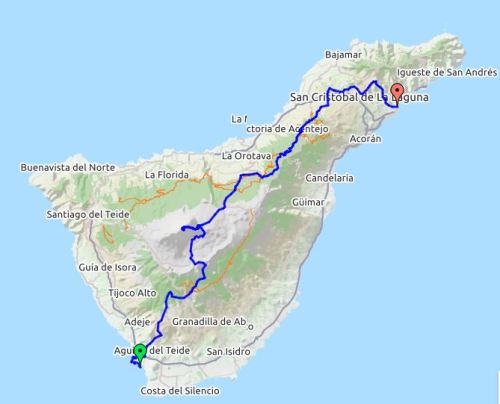
The evening is made pleasurable by an excellent meal with good wine in the restaurant, I could happily slip into this luxury life, I didn’t say that – back to tomato sandwiches tomorrow. We replan our onward journey on the GR131, scaling Mount Teide will have to wait for another day.

TENERIFE GR131. Vilaflor – Parador Teide.

Ash and lava.

Breakfast was spent with the young English couple, both active fell runners from the Peak District, who were on a tighter more ambitious schedule than us oldies.  Good to see their enthusiasm, we were away before them but soon overtaken!

From the village, the ancient way climbed steadily on a well defined paved path through terracing of vines and into woods. Steady progress was the order of the day as we had 1400m to climb in the hot sun. There were no fuentes  so all liquid had to be carried and frequent refreshment stops made. As it was a Sunday there were more people out walking, running and mountain biking this popular trail.

Distant Guajara mountain.

Distant Guajara mountain.

We were heading for Guajara, 2715m, which we would circle to a col before dropping into the caldera. Highlights today were first all the volcanic ash we walked through and then the amazing lava fields and formations higher on the mountain. The compressed ash was metres thick and all colours, reminders of distant eruptions. Out of interest whilst we were here new low-level seismic activity was reported. Mount Teide  erupted in 1909 and the previous last reported increase in seismic activity dates back to 2003 when a rift opened on the north-east of the volcano. Needless to say the ground didn’t tremble below our feet. A section of eroded white ash was followed by a whole field of black ash up which climbed an endless avenue of a path. The authorities don’t want people wandering everywhere. From the top of the ash field a tortuous rocky path eventually landed us at Degollada de Guajara, 2373m. Gran Canaria was seen to the east. We stopped for lunch whilst walkers were appearing from all directions, this area around the Parador is easily accessible. Also spotted was a Great Grey Shrike. Dropping into the caldera a wide track was followed past weird lava shapes. I realised that I had previously climbed in this area and I recognised some of the routes, some climbers were busy today enjoying the warmth at this height. Mount Teide loomed above.

Degollada de Guajara.

Degollada de Guajara.

Climber in lefthand crack.

Arrival at the Parador was a bit of a shock, cars everywhere and the cafe and terrace packed with people. We booked into our room and sat in the hotel lounge to avoid the melee.

TENERIFE GR131. Arona/Ifonche – Vilaflor.

 A shortened day.

We were a little chastened after yesterday and neither of us feeling ready for a long day with 1400m of ascent, I know I’m getting soft. Walking to the bus station at 7am we suddenly decided to shorten the day by going directly to Ifonche by taxi, saving 7k. This leaves me with another little section to finish some other time but there looks to be a pleasant circular walk from Arona. We were dropped off at a bar, unfortunately closed, and wandered off for a view down the dramatically named Barranco Infierno and distant La Gomera. Once back on the Gr131 waymarks were plentiful as we climbed a ridge between two deep barrancas. Tagaste [white broom], prickly pear cacti and Cistus [rock rose] give way to pine forest. There have been forest fires here but the Canarian Pine is able to regenerate low down from the charred bark. We drop into the Barranco del Rey and then through old terraced plots and the occasional ‘era’ threshing circle. In the next barranco there is a fine old bridge, a good spot for lunch. Going up Montana de la Vica, high point of the day 1600m, there are many paths in the red ash and lots of people heading in the opposite direction. Water pipes are everywhere and down the otherside fields full of potato plants, papas arrugadas is the commonest dish in Canary cafes. Vilafor is a small town with an attractive church square where outside cafes serve beer and coffee. We chat to a young English couple who had passed us earlier in the day.  Our hotel, Rural Vilaflor, is an old house in a quiet side street strangely run by a friendly Russian couple. Tourists disappear in the evening and most cafés close, but we find one open for an average dinner.

TENERIFE GR131. Los Cristianos – Arona.

Escaping the suburbs.

This should have been an easy stroll but we arrived in Arona hot and sweaty after a frustrating morning and a climb of 900m. We had underestimated the climb and distance and come to realise our map is poor. The GR131 didn’t exist on this section. Not a good start and in the evening we need a good meal and wine to lift our spirits.

Playa de la Americas and distant Mount Teide.

Playa de la Americas and distant Mount Teide.

From our airbnb we headed down to the harbour and began a coastal walk – the well known Los Cristianos, Playa de las Vistas and Playa de las Americas. It is already above 20°, people are heading for the beach, joggers are sweating past and the hint of full English breakfasts wafts out of the cafes. In fact we stop off for an orange juice and scrambled egg.        There has been no sign of any waymarks for the GR131 but we follow the red line depicted on my map and head inland. Busy roads are negotiated and the motorway crossed. We are feeling pleased with ourselves until we become trapped in a new housing  maze not shown on the map.  The hills can be seen across vast banana plantations, but there is no way out and we turn tail and head down again, always a humiliating experience. The locals can’t help and thoughts of giving up cross our minds as we traipse the pavements and overheat.  By chance, we meet a Dutch couple doing a circular walk, their GPS points us onto a scruffy lane marked private. At last we are heading into the hills up this narrow road which leads to a water pumping station. A fortunate small arrow points our way and silver paint marks help keep us on a small track up to an aqueduct crossing the now rough hillside towards Roque del Conde.  However familiar plants appear, deep gorges drop away and we feel  in the wilds at last. Steep climbing brings us to a col with views back down to the holiday sprawl. In complete contrast, an isolated pig and goat farm is passed which looks to be in another century. Steep lanes lead into the small town of Arona where lots of walkers seem to be congregating, no doubt having enjoyed pleasanter paths than ours. There is no accommodation here so we hop on a bus, full of walkers, back down to Los Cristianos.

TENERIFE GR131.


JD and myself are back on Tenerife and staying once again in a fabulous airbnb next to the church, Nuestra Señora del Carmen in Los Cristianos. All is peace and tranquility with this family. We go round the corner to the busy locals’ Restaurant Raymond  and enjoy a typical supper, salad and then Merluza with Papas Arrugadas. The house Tenerife wine is good but the large serving of post dinner fire water Orujo  [ a transparent spirit from the distillation of the remains left after pressing the grapes with an alcohol content often over 50%] could mean trouble. Their paella apparently is superb – next time.

The GR131 through Tenerife follows in the main part El Camino Natural de Anaga-Chasna an ancient route crossing the island used when most people lived away from the piratical coast. My map shows the route from the harbour in Los Christianos to the harbour in Santa Cruz, 125k, thus linking with ferries to the other Canary Islands, the original idea of a continuous route through all seven. The Cicerone guide only details it between Arona and La Esperanza, 85.5k, as does the signing on the island, we were to find out later why.

We also intended to visit the summit of Mt. Teide on the way which involved pre-booking the Altavista Refuge on the mountain to avoid the restricted permit system.

ANCIENT WAYS.

Beamsley Beacon and Round Hill.

Two ancients going their own way.

There will be lots of posts with Autumn colours at this time of year, I went abroad a week ago whilst the leaves were green and have returned to spectacular trees. But today I hardly saw a single tree on these bleak moors. The general visibility was poor also but a combination of The Pieman and The Rockman as companions was sure to provide an entertaining day.

I have driven below on the A59 hundreds of time and looked up at the craggy top but I had never ventured up there. By our roundabout stroll we found were reminders of ancient routes long before the present roads. There were numerous old mile/directional stones and many boundary stones suggesting lots of foot and mule traffic at one time. Tracks tend to connect and the places mentioned on the stones give some idea of destinations. What was the nature of peoples travel – monastic or trade routes?  – people certainly wouldn’t have come up here for pleasure. On the map there is also a Roman road shown but no trace of this was passed today. The whole area was rather boggy, an understatement, and progress was slow and must have been troublesome for those who passed before. There is no trace of paved mule routes here, whereas in many Pennine areas these are an outstanding feature. On the map there are mentions of ‘cup and ring’ stone markings but we didn’t notice any, didn’t look hard enough.

Enough of way stones – there didn’t seem to be many obvious paths…Up on the drier heather slope there had been some harvesting of the heather which was bailed up – to be used for what? There was yet another mystery, two detached boot soles.

Having traversed Round Hill [409m] we arrived at Beamsley Beacon itself [393m], a more popular destination being a short walk from the car park. The prominent Beacon was part of the chain of fires that could be lit as warnings during the Napoleonic wars, recent uses of these beacons have been more celebratory. The large stone cairn is thought to be a Bronze Age burial site but has never been excavated. The trig. point bares a memorial to a crashed Lancaster Bomber crew from the Royal Canadian Air Force killed 5th November 1945.Will have to come back for the views.


LIGURIAN COAST and CINQUE TERRE, day6.

                                Cinque Terre.      Corniglia – Manarola – Riomaggiore.

On our final day the plan was to complete the Cinque Terre walk but Tren Italia workers had other ideas and called a strike., fortunately a rather soft one – from 9am to 5pm. So with an extra early start we were in Corniglia just after 8am at the base of those 382 zigzag steps we had descended a few days ago. There is a sign at the bottom advertising a pharmacy at the top – ?oxygen. Once at the top we were ready for some breakfast in one of the  cafes in the little square of this rather strange promontory village. The coastal path has been destroyed so we take the higher route over the headlands via Volastra, this involves some fairly stiff climbing up stone steps. There are some great views back down to Corniglia to take our minds off the task. Most of this area is devoted to vines with stone walls supporting terraces down the steep hillsides. Any grapes grown here involved arduous work over the centuries. In recent years a type of rack rail has been installed for transport on the slopes, it all looks very precarious. No wonder the wine tastes good. The day is perfect with hot sunshine and blue skies and this section of the walk is relatively quiet. Soon we are descending steeply into Manarola with its busy streets above the harbour. The bar I chose for a light lunch of bruschetta and tomato has the only miserable waitress seen all week. From here to Riomaggiore the famous Via Dell’Amore clinging to the cliffs has also been destroyed by landslides so once again we haul ourselves  [literally in parts]  up steep steps. The place has suddenly become very popular with all sorts of humanity struggling along the trail. The drop into Riomaggiore is just as steep and we are hot and sweaty by the time we reach it. A swim in the stony bay round the corner is first priority and a lazy lie on the beach to dry off in the sun. There is time to explore the higher narrow streets of the village before going through the tunnel to catch a train back, now the strike is over.

In the evening we enjoy a rather over elaborate and expensive meal in a hilltop restaurant, La Ruota, the free Grappa at the end reminding me with a headache for the journey back to England the next day. It has been great to be back in Italy and this area is certainly spectacular if over touristy. I would like to return, alone or with a couple of friends, and explore some of the quieter coastal paths and the routes going into the hills inland.

LIGURIAN COAST and CINQUE TERRE, day5.

                                           Santa Margherita Ligure to Portofino.

Years ago there was a good Italian restaurant in Preston named Portofino, candle lit dinners serenaded by a guitarist who happened to be Spanish, but never mind. The name stuck with me and I had a hankering to visit this place. So this morning we get off the train in rather elegant Santa Margherita and walk across the promenade past a statue of Christopher Columbus. He was born in Genoa up the coast so I’m not sure of the significance of his statue here.

Santa Margherita.

Santa Margherita.

It was raining as we set off into the hills –– steep tracks through pine and chestnut trees eventually brought us out at a cafe next to an old mill.  Here a welcome coffee and a drying out helped us on our way. The whole area was very green and luxuriant but there was a lot of damage from recent storms.  Soon we were looking down on the natural harbour of Portofino.Portofino has become the Italian playground of the rich and famous and was full of tourists. I didn’t  venture into the jewellery and fashion boutiques, in fact I ate a sandwich on the castle promontory, there are some fabulous views of the harbour from up here. I then braved a coffee in the over priced Bar Pasticerria up the side street. They had photos of the visiting rich and famous from the past.


We had a route march back along the coast to catch the train in Santa Margherita.                                            Portofino – been there, seen it, couldn’t afford the T shirt.


LIGURIAN COAST and CINQUE TERRE, day4.


                                                 Boat trip Monterosso to Portovenere.

There were no walks scheduled for today, people were doing their own thing. I considered a walk northwards from Moneglia but fancied a change and the weather forecast was for morning rain. So after a leisurely start, I meant to say the breakfasts at the hotel have been excellent,  I was on the train to Monterosso again. From here I was joining the tourists on the boat trip down the Cinque Terre coast and on to Portovenere. Actually there weren’t many people on the little boat as it was miserably damp. All the five towns were viewed from the sea which gave a different perspective to the walking days. We called in at Vernazza, Moneglia and Riomaggiore, Corniglia doesn’t have a harbour.

MONTEROSSO.

MONTEROSSO.

VERNAZZA.

VERNAZZA.

CORNIGLIA.

CORNIGLIA.

MANAROLA.

MANAROLA.

RIOMAGGIORE.

RIOMAGGIORE.

I stayed on for the longer leg to Portovenere. By now the weather was stormy and most people had retreated off the upper deck. This a much larger town, again a UNESCO World Heritage Site, at the far end of the peninsula before La Spezia Bay. Its harbour is lined with brightly coloured houses. All these towns seem to have perfect pastel painted houses, I wonder if there is a plan or colour coordinating police?Narrow medieval streets lead up the hill to a castle and a church on the promontory, once the site of a temple to Venus (Venere in Italian) from which Portovenere gets its name. The main street, lined with shops, is entered through an ancient city gate. Here a small family cafe, Bar Zurigo, rather than one of the expensive restaurants was chosen for a lunch of Anchovies with a view over the harbour. By now the sun had come out and I strolled up the hill to the church and views up the rocky coastline and across La Spezia bay to Palmaria Island.

A tortuous bus ride to La Spezia and then the train back to Moneglia. I’m becoming very familiar with the stations on route but the line generally is disappointing due to all the tunnels, it serves a purpose.


LIGURIAN COAST and CINQUE TERRE, day3.

                  Cinque Terre.           Monterosso – Vernazza – Corniglia.

Looking back to Monterosso.

The coast back to Monterosso.

This week is different for me and I’m not sure about walking with ten other people no matter how charming they may be. I feel I’m missing things on the way – flowers, birds, houses, shrines etc. OK you see them in passing but if I was on my own or with another much more time would be spent observing and absorbing. More time is spent chatting rather than experiencing the route. If you drop off the back to contemplate the rest are waiting for you to catch up – I don’t need that!  Anyhow worse is to come today as we hit the crowded Cinque Terre paths.

Our morning train takes us to Monterosso the most westerly town of the Cinque Terre – Five Lands.  The old part of town with narrow streets full of cafes also had two unusual churches. All humanity was here – Americans, Japanese and the rest of the world’s tourists. Some are content to eat ice creams in the expensive port but many are clambering in various attires along the famous cliff hugging path. Traffic lights would not seem out of place to regulate the flow of people. An entry ticket is needed by the way. Anyhow the path high above the sea is dramatic. We walk through pine and oak forests and terraced vineyards. There are good views back to Monterosso and eventually down to our next destination – colourful Vernazza,  with its natural harbour dominated by the Doria Castle.

Monterosso station.

Monterosso station.

Monterosso beach.

Monterosso beach.

Lunch, local Focaccia bread with Pesto, is taken in a little cafe away from the port itself but everywhere is crowded.

Then more steps climbed out of the village and we traversed high again towards Corniglia which is perched on a promontory rather than at sea level. It was  an interesting place to explore with little passageways leading nowhere and good views of the coast. There was time for an ice cream before heading down flights of steps [382 I didn’t count them] to the station platform for the return train.

Looking back down on Vernazza.

Looking back down on Vernazza.

Corniglia.

Corniglia.

Onwards to Manarola.

Onwards to Manarola – for another day.

dsc03694My antisocial self survived, actually enjoyed, the day: I’m getting into tourist mode. Back in Moneglia a swim refreshed me ready for a meal at a small restaurant [U Limottu] up an unfrequented side street. Ate the best fish so far in this town and the best wine from Colli di Luni a complex red Niccolo V.

LIGURIAN COAST and CINQUE TERRE, day2.

                                             Rapallo, Montallegro and Chiavari.

Back on that train again, this time to Rapallo. But for some strange reason the train only goes as far as Sestri Levante where we have a 40 minute wait for an ongoing train, time for a walk round the town of impressive buildings and a coffee. Once at Rapallo we cross the small town to make our way up to the Funicular station for a squashed 500m ride to the upper station. A short walk up steps leads to The Sanctuary of Our Lady of Montaleggro. Here in 1557 a vision of Madonna was seen and a sanctuary built for pilgrims, the present day impressive marble facade dates from 1896. dsc03547From here we had a well paved level track [with stations of the cross]  along a ridge of oak and chestnut trees, unfortunately the mist interrupted coastal views.

Looking across the Tigullio Gulf towards Portofino.

Looking across the Tigullio Gulf towards the Portofino peninsula.

For most of the day the pilgrim/mule trail was cobbled, often between old stone walls running across terracing on the hillside. Inland low hills, with scattered farmsteads, led up to the distant Apennines whilst down to our right were glimpses of the coast. There was a steep scramble up a rise in the woods and we were nearly mown down by mountainbikers on the descent. The ornate church of La Madonetta suddenly appeared in the trees further on.From here paved ways led down to the town of Chiavari which had some grand buildings in its centre and lots of alleyways leading nowhere. The railway station was tucked away in a tunnel.  dsc03575 dsc03573This was a relatively short walk as we had a wine tasting to attend in the early evening. This took place in an old house used in the past for the preparation of Anchovies which were an important food through the winter months. Our host runs a restaurant here and gave an entertaining and informative presentation helped by his young daughter. [blurry picture below] One of the grapes used in this region is the  Vermentino producing a light fruity dry white wine. We tried four from slightly different areas and methods.  After that we staggered out into the street and into a nearby restaurant [Gian Maria] for a tasty prawn spaghetti and of course more wine.

LIGURIAN COAST and CINQUE TERRE, day1.

                                     Framura, Delva Marino and back to Moneglia.

Breakfast was promising. Our group of ten also.

The railway along this coast connects all the towns directly whereas the roads are a convoluted and slow affair. Both commuters and tourists use the train. In the cool morning we await the train heading south to Framura, two stops away, only 10mins late today. Once at Framura the walking starts, typically we are to find, with steep steps out of town. Now is not the time to chat with one’s new companions. Soon we are high above the coast with spectacular views east.A sunny square materialised with an old defensive tower and then we were heading down again on a track through pines, giant heathers and strawberry trees.A few streets led us onto the beach at Deiva Marina and I couldn’t resist a swim in the invigorating Mediterranean, I was soon dry in the hot sunshine. A nearby cafe provided caffe macchiato. There was a chestnut festival in the village which was just getting going with music and roasted chestnuts.Jollities over a steep ascent through oak forests brought us out at a wooden cross high on Monte Telegrafo, 443m, but views were restricted by the trees. Downhill once again to the prominent village of Lemeglio with it’s black and white church –  – and then on old paved tracks back to Moneglia.

Moneglia

Moneglia

For a first day’s walking this had been quite tough with steep gradients and nearly 3000ft of ascent. This area is outside the Cinque Terre region and few other walkers were seen. A session in the hotel’s Jacuzzi helped aching muscles before an excellent meal of mainly fish and ten new names to recall.

LIGURIA and the CINQUE TERRE – arrival at Moneglia.

“Cinque Terre is a string of centuries-old seaside villages on the rugged Italian Riviera coastline. In each of the 5 towns, colourful houses and vineyards cling to steep terraces, harbours are filled with fishing boats and restaurants turn out seafood specialties along with the Liguria region’s famous sauce, pesto. The Sentiero Azzurro hiking trail links the villages and offers sweeping sea vistas.”

That sold it for me.

I’ve only really been to the Ligurian coast once – climbing based on Finale west of Genoa. We also came close finishing the three week GEA in the Apennines to the north of La Spezia a few years ago but hadn’t time to visit the coast.

This time I’m heading straight to Moneglia a coastal village between Portofino and the Cinque Terre. My fellow passengers on the flight were from Durham and I slipped back into my early accent as chat passed the time quickly. Its interesting how a common background leads to familiarity. An early arrival at Pisa airport, thanks Easy Jet, had me on a bus to town. The ticket queues at the rail station were a testament to Italian inefficiency but after half an hour or so I  was on a train to La Spezia. A dash saw me on the coastal train onwards. Glimpses of the Med. and the iconic villages flashed past but a lot of the time we were in tunnels.

Moneglia looked a bit run down but improved as I approached my hotel, Piccolo, near the sea front. Disappointingly there seem to be buildings blocking off the sea front itself. I realise later that this little town is much quieter and less touristy than the other resorts.

I’m here in roundabout way on an Exodus walking holiday, the rest of the group are coming later on a flight from London. So I make myself at home, have a swim in the sea, refresh and go out to find supper. My choice, Restaurant Vela, is a great little family run place and they look after me well.

Moneglia -our street.

Moneglia -our street.


A weekend walking by water.

One can’t always be in exotic areas, Lancashire is enough. Mel was up for a few days, my planning had been delayed by other arrangements, so on the hoof we enjoyed the following days.

Thursday. 11.30 Pick up at Preston station .                                                                                     12.00 lunch at the five star RK Sweet Centre – masala dhosa £2.50.

14.00 a walk around the reservoirs in Longridge visiting the shops to purchase delicacies and drink for tonight’s home cooked Italian meal.

Longridge reservoir.

A Longridge reservoir.

Friday. A late start saw us in a compulsory Chinese buffet in Southport.

After the Egyptian Room in the Atkinson Gallery we spent time looking at the eclectic historical exhibits relating to the Sefton coast –  lifeboats, Bootle Docks, shrimping, Dan Dare, Meccano.

On the spur of the moment we drove down the coast to Crosby to view Antony Gormley’s ‘Time and Space’. It was mid tide so the figures ranged from full bodies to heads barely visible in the sea.

Crosby beach.

Crosby beach.

Saturday. Another late start, shan’t tell you why, and we were following the Ribble Link canal towards the Ribble. We didn’t go all the way but cut across a golf course to the Lancaster Canal which we followed back towards Preston, stopping off at a cafe in the UCLAN sports ground. We skirted Haslam Park and continued along the surprisingly green route into the centre of Preston where goods from the canal were transferred to trams to cross the river and join up with the Leeds/Liverpool canal. The modern Ribble Link strives to do the same but I wonder how many boats use this facility.     A glorious sunny day.

Lancaster Canal in Preston.

Lancaster Canal in Preston.

End of the line in Preston.

End of the canal in Preston.

The excellent  Egyptian cafe in Preston provided food as good as Cairo in the evening.

Sunday. The weather remained good. Another ‘watery’ walk, taking in Cockersand Abbey, coastal walking, Glasson Dock, another canal and Thurnham Hall, was enjoyed in the sunshine.

Cockersand Abbey.

Cockersand Abbey.

Glasson estuary with the damaged Plover Scar light.

Glasson estuary with the damaged Plover Scar light.

Glasson Dock.

Glasson Dock.

Link canal with Bowland Fells in the distance.

Link canal with Bowland Fells in the distance.

Back home it was time for an ‘Indian’.

Monday. Take Mel back to the station until we meet again next Spring on the Thames Way for some more ‘watery’ walking.

http://www.rksweets.com/

http://www.gourmethouserestaurant.co.uk/

http://www.theatkinson.co.uk/

http://www.lolaegyptiancuisine.co.uk/

http://www.hamadanrestaurantlongridge.co.uk/

Zillertal Rucksack Route. VIII.

Friesenberg Haus – Breitlahner and home.

This hut had closed early this year but we wanted to do more of the high level walking on our last day so we walked up to it and along the ZRR before coming down to the valley. It was a misty morning but promised better, the Russians disappeared early up towards the Furtshaglhaus and higher things. We trudged up through the woods into a vast hanging valley meeting some of the staff from the Friesenberg coming out for the last time. An excellent stone track zigzagged out of the valley up to the hut on a higher bluff. At almost 2500m this is the highest hut in the Zillertal. It has an interesting history – built originally in the 20’s as a private Jewish establishment. As the war approached the area was used to train elite German troupes  which put the hut warden in a difficult situation. But tolerance prevailed between mountaineers and there is a bronze plaque outside the hut celebrating against “intolerance and hate”. Today we sat on the steps for a short break as the shutters were closing for winter. We continued along the route in and out of clouds, it was arduous and we realised we couldn’t get as far as we had hoped. Fortunately there was a signed track leading down to Breitlahner – this we followed but it didn’t seem to be used much. Marmots were screaming at us in one area, we realised that we hadn’t seen much wild life on this trip – birds were particularly absent.  Down and down we went into boggy ground and then welcome dwarf pines. The day became hotter and on reaching the valley floor we were ready for a rest. Paths led alongside the gorge, the road had disappeared into tunnels, until we emerged at the Breitlahner which turned out to be an old traditional alpine hotel. A bus whizzed us through Ginzling into Mayrhofen, the scenery was spectacular all the way.


Spot the marmot.

Spot the marmot.


Good to be back at the friendly Zillertal Gasthof, we enjoyed a celebratory meal featuring wild mushrooms at the excellent Tiroler Stuben – the rockman had a headache the next morning! The journey back to Janbech and Munich was easy. We found ourselves by chance in the wonderfully atmospheric  Augustiner Restaurant, the Oktoberfest is just getting underway.

The SBahn train to the airport was halted because of people on the line. We didn’t really know what was happening but decided on a panicky train back to Munichost  and then an expensive taxi ride had us at the airport with minutes to spare. An exciting end to our trip.

Quote of the day –   that was close”      at the airport.


Zillertal Rucksack Route. VII.

A trip up to Italy – PfitscherjochHaus.

The weather reverted to rain and low cloud so an easy walk up to Italy was the obvious choice for today.  We passed some fine waterfalls up the valley and before we knew it we were at the old border post. A little further the Italian hut appeared out of the mist. There was a warm welcome in the modern hut. We settled in for lunch – pasta and good coffee. A large group of cyclists arrived from somewhere to stay the night. The hut has a chequered history, it was blown up by the Italian army in 1966 due to border disputes, rebuilt in 1980 and has continued to provide mountain accommodation.

Compare with yesterday's view from the balcony.

Compare with yesterday’s view from the balcony.

Pfitsherjoch Haus 2277m

Pfitsherjoch Haus 2277m

More food - Italian this time.

More food – Italian this time.

We stole away and retraced our steps down the valley in the mist.

Back at Dominikushûtte supper was interesting – can’t remember the food. A man in soaking camouflage kit burst in from the dark carrying a baby kangaroo style, his wife followed. They turned out to be Russian and doing a similar trip to us! The baby must be hard as nails.  An unfortunate retarded chap [sorry for any unpolitical phrasing] was having supper with his carer and making grunting noises. I went to the loo downstairs and whilst there had the scary movie moment as a stumbling grunting ogre came towards me. Enough said.

Today’s quote – “mustn’t grumble”    determined to enjoy the rainy day.

Zillertal Rucksack Route. VI.

Neumarkte Ronde to the Olperer Hūtte.

The day dawned unexpectedly bright and sunny. We made a quick decision to do this high level circular walk after booking in at the Dominikus for a couple more nights. The breakfast was rather disappointing considering the accessibility, no fruit or eggs, so we were away early.  Back along the road to pick up the signed way, 535, a gradually ascending good path up the side valley, the unpronounceable  Unterschrammachbach.  Lots of people were descending from an overnight Saturday at the hut, suggesting a cramped and noisy night. Fast flowing streams were crossed on new bridges until we met up with the Berliner Höhenweg in a large mountain bowl under the Olperer 3220m. Four lads were heading up to an unseen pass leading to the Geraes Hütte.  Signposts put us on our more modest way switchbacking across the contours coinciding with The Peter Habeler Way [the famous alpine and Himalayan mountaineer haling from Mayrhofen] This route, established in 2006, was well paved with slabs of rock – how do they move them? Views down to the Schlegeis lake and up to the Hochfeiler became more impressive as we moved round. Eventually the Olperer Hütte came into sight on its perch looking most unimpressive from an architectural  point of view, ‘hen-house’ was the phrase we used. It was rebuilt in 2006 and was certainly impressive inside. We sat on the balcony with our teawasser [stingy Brits] enjoying the view down the valley. A group of pygmy goats entertained us below. The way down was heavily used and unpleasant until it entered the pine forest before reaching the road. People seemed to be ascending late in the day. We were back fairly early in the Dominikus enjoying a Radler [citrus shandy beer] and chatting to the family [see quote of the day]. the hut seemed to get busier as the evening went on. Dumplings and sauerkraut were on the menu!

Morning view from the balcony.

Morning view from the balcony.

Unterschrammachbache.

Unterschrammachbache.

The upper bowl.

The upper bowl.

Looking back down hanging valley.

Looking back down hanging valley.

Well paved Peter Habeler Way

Well paved Peter Habeler Way

Olperer Hutte coming up.

Olperer Hutte coming up.

Sandwich with a view.

Sandwich with a view.

You have to be there.

Dumpling – you have to be there.

Quote of the day – “the sun shines on the right shoes”  our hosts’  misinterpretation of righteous!

Zillertal Rucksack Route. V.

Furtschaglhaus – Schlegeis, Dominikushütte.

Woke to sleet and snow with nil visibility. So a leisurely breakfast and sitting around for a late start as fortunately we were heading down the valley and decided to take a half day. We phoned the Dominikushütte and booked a room, they sounded pleased to have us as the bad weather would put a dampener on the weekend. There was a trail through the snow going down steeply to the valley below, the rocks were slippy and we took our time. Very few people were coming up and our route of yesterday would be out of the question. We arrived in the valley next to the provisions lift from where a track ran to the lake/reservoir. By now it had stopped snowing but the clouds were down revealing only occasional glimpses of the surrounding mountains. We dawdled along the lakeside track, walked through a mainly deserted carpark and arrived at the dam. This 70m wall was built in the 1960s and provides hydroelectric power as well as flood control for the Mayrhofen Valley. The original alpine hut was destroyed in the process and our present accommodation, Dominikushütte, was constructed higher above the water. We received a warm welcome from the family and dog, bowls of Knödel soup went down well as we dried out. Our room was airy and spacious, a change from the mountain huts. We are still at a height of 1800m and the afternoon was gloomy with no one else about, time for festering [an unusual verb describing our activity]     They had given the chef the night off as nobody else was expected but slowly more people started arriving and by evening it was quite busy.  By special request we had Tyrolean Grosti with a great celeriac remoulade for supper. A wicked schnapps finished off the meal.We had three days left and wanted to visit the last three high huts but the forecast was poor, We deliberated over various options but went to bed undecided, lets see what the morning is like.

Quote of the day – “this is better than sleet”  as the morning snow piled up.

Zillertal Rucksack Route. IV.

Berliner Hütte – Furtschaglhaus.

The Schonbichlerhorn.

The Schonbichlerhorn, today’s objective.


Today takes us over one of the highest ‘walking’ passes in Austria. The forecast is for rain later so we plan an early getaway. The breakfast in the Berliner is poor and expensive, they could do so much better – some fruit juice and maybe boiled eggs. The hardy young crowd who eat their own breakfast on the terrace are away early, we are happy with 7.15am. It was uphill all the way, at first through shrubs on zigzags and then at a rock wall we took a shelf up to the right into a rocky area. Here a ridge soared upwards towards a vertical rock face, surely we don’t go up there but yes a few hundred metres of scrambling led on. Poles were packed away for the hands on experience, there were cables but they weren’t needed as the rock was solid and full of jugs. From the col the summit cross of Schonbichler Horn, 3133m, was 5mins away. The rockman proudly bore the summit stamp on his forehead and we signed the book “post Brexit”. Fantastic views as you can imagine, a whole new world opened up to the NW, The Tuxertal Alps with the Olperer 3426m prominent. To our left were glacial systems coming off the Grosser Moeler, 3480m, and the  Hochfeiler, 3510m, the highest peak in the Zillertal. We sat and ate more of that stale bread and cheese whilst looking around. Cables led us down loose ground but there was no hard packed snow that had been so difficult last year, our micro spikes were never used. After an 8 hour day the Furtschaglhaus was a perfect traditional hut with super friendly guardians. An early supper and we were in bed way before the beer-swilling weekenders at the hut. We never meet any British walkers.

Looking back to the Berliner and yesterday's pass.

Looking back to the Berliner and yesterday’s pass.

Easy cables on the lower ramp.

Easy cables on the lower ramp.

It goes up there somewhere...

It goes up there somewhere…


Pausing for breath.

Pausing for breath.

Easy scrambling to the top.

Easy scrambling to the top.

The Grosser Moseler in the distance.

The Grosser Moseler in the distance.

Sliding down.

Sliding down the otherside.

Hochfeiler at 3509 the highest in the Zillertal.

Hochfeiler at 3509m the highest in the Zillertal.

The Furtschaglhaus.

The Furtschaglhaus.

Serious eating and drinking.

Serious eating and drinking.                                                                                                                                                    Quote of the day – “this must be where the cables start”  –  as we looked up at the precipitous face.