You will notice that GR131 has not appeared in today’s title. Instead of going back up the mountain, we were going to the seaside. An hour’s bus ride across and through the Island [2.10 euros] and we were changing buses in Los Llanos to go down to Puerto de Tazacorte. I managed to hobble down to the black beach and have a dip in the waves until I realised my leg didn’t want to swim. A hilarious moment happened when we tried to walk across the beach barefoot and realised our feet were actually burning on the black ash, a lot of hopping and jumping onto clothes ensued. A decent fish restaurant served us lunch whilst looking up at the steep path we could have been coming down on the GR131. Ah well, some other time.
The night was spent in the delightful old part of Los Llanos. Tree lined streets were perfect for the relaxed café culture. The trees are 150yr old Indian Laurels, a type of Ficus, and are crying to be climbed.
Santa Cruz was explored the next day. Old narrow streets, flower decked balconies, museums, seafront restaurants, little bars. Not bad for an anticlimax.
A final float in the sea and we were heading home well impressed with La Palma – La Isla Bonito. Hasta luego!
Tropical the island breeze All of nature wild and free This is where I long to be La isla bonita…
I said yesterday’s walk was the Island’s most popular, well maybe for serious hikers as this morning there were crowds heading to the lighthouse. Not Virginia Woolf’s soul searching one. We had a leisurely start after the usual bar desayuno – freshly pulped orange, tomato tostada and a coffee, not bad for 3euro. The coffee on the Canary Islands varies in quality, I think they grow and roast their own which often has an unusual taste.
Navigating out of town was made easier than usual by heading for a black volcano cone. A large visitor centre has been built here, Volcan de San Antonio which erupted 1677. It looked interesting but only accessible through the centre who charge for the privilege.
We followed the fence around it down ash slopes where vineyards have been established.
Ahead was Volcan Teneguia which erupted as recently as 1971, it makes you wonder when the next one will be. [watch the video below] The path alternated between blocky larva flow and very loose ash, all the time aiming for the Atlantic and the two lighthouses at Faro. The last time I’d seen such young rock was on Iceland from where I picked up a specimen only 2 years old.
A few fishing boats were bobbing in the waves off what looked an inhospitable coast. We commented on the fact that you hardly ever see a seagull.
The sea was wet as wet could be, The sands were dry as dry. You could not see a cloud, because No cloud was in the sky: No birds were flying overhead— There were no birds to fly.
By now there was a steady stream of walkers coming down the paths to join the crowds of tourists arriving by car to look around the salt pans at the Faro. The original basalt lighthouse had been decommissioned following tremor damage and replaced with the more modern one in 1985, but this is automated now.
On the larva beach there are extensive salt pans and today men were working in them, not sure how much of a commercial venture this is or more of a tourist attraction.
We retreated to the pleasant veranda above the shops’ hustle and bustle for a beer and tapas, papas arrugadus and cheese croquettes with mojo sauce. We were feeling pleased with ourselves for finishing this difficult four day section of the GR131 and planned the next two days. We had descended from 2426m to sea level and in those days also climbed 2200m if you see what I mean – no easy downhill.
Slowly the place filled up with walkers quenching their thirsts before catching the bus back to their hotel or Fuencaliente. We joined them for the bus trip first along the coast through all enclosing banana plantations to a ghastly looking hotel complex in the middle of nowhere then back up the twisting roads to town. We picked up our rucksacs from the pension, yes we had enjoyed an easy morning unburdened, and caught the next bus up to the east coast, Los Cancajos. Strangely it was only when we alighted here that I realised I could hardly walk for pain in my hip. On that recent trip to Cornwall I had noticed pain with all the steep steps but ignored it prior to coming here. Presuming it was just spasm from sitting I soaked in the bath and had a beer only to find I could hardly walk to the restaurant for supper. Tomorrow was to be another long committing walk down the central caldera from Roque de los Muchachos towards the west coast with no escape possibilities. I agonised over dinner and prompted by JD cancelled the early morning taxi to the summit. Once that was decided we enjoyed a very good local red, Tamanca Negramoll, changed plans and hobbled off to bed.
[ Just a word of praise for our apartment block, La Caleta. The staff couldn’t have been more friendly, they were interested in our exploits and very helpful with our change of plans. The rooms were basic but spacious, lovely pool area, tranquil atmosphere and good dining. https://www.lacaletaapartamentos.com/en/home.html ]
This is the most popular one day walk on the Island following a ridge of volcanoes. Even while we were packing in the dark taxis were bringing walkers to the start. It is Sunday and lots of young walkers passed us throughout the day. Our plan was to get away early and do the climbing before the heat of the day. We had been told that the excessive heat we were experiencing was due to tropical air and dust from the Sahara – the Calima. Ahead of us in the trees were three seizmologists taking readings on the ground. There has been recent activity under La Palma but these three told us that it has diminished, still it was reassuring to have our personal warning team proceeding in front of us.
Slowly we gained the crest and weaved between volcanic cones on black ash paths.
Most of these erupted back in the 15 -16th century though Monte Negro on our right appeared in 1949.
On the left were seas of black larva flows, dramatic geological features set out before us.
Someone must have time on their hands…
Higher up there was a short detour to the rim of the massive crater of Volcan Deseada. Disappointingly we never had the distant views to the other Canary Islands.
Ahead were more volcanic cones but the track wound down into a large ash area with scattered trees, one of these trees gave us shade for lunch – the last of the tuna! Still at 1800m. On and on through the vast ash scenery as the temperature reached the 30’s with little shade from the scattered trees. We marveled at the tenacity of these trees to get a footing in the arid ash. This is dusty walking.
The Walrus and the Carpenter Were walking close at hand; They wept like anything to see Such quantities of sand: ‘If this were only cleared away,’ They said, ‘it would be grand!’
Some awkward larva rock made walking difficult on the final descent into Fuencaliente [Los Canarios], 780m,
At the entrance into town there is a statue celebrating all the walkers who come this way and more importantly contribute to the local economy. Glad to oblige we headed straight to the nearest bar for refreshments. Near the statue we later found plaques recording results from recent Transvulcania Ultramarathons with unbelievable times now below 7hours for the 74km course.
We had a great little pension up a side street for the night. A shower washed off most of the sweat and dirt but when we shook our boots out we were amazed at the amount of black ash that fell out – sorry if we blocked any drains. A hidden restaurant in the lower part of town provided some fabulous food but dubious local wine.
We had heard there maybe a food van at El Pilar where we planned to bivy tonight so set off with high hopes. Today was much easier walking with well graded paths and not so much ascent. Steep zigzags below the refuge brought us back onto the caldera rim, though there were still no decent views into it. A late breakfast was taken sat on a branch of one of those magnificent Canary Pines.
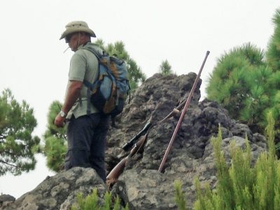
A gun shot scared us, today is Saturday and one is allowed to hunt the introduced Barbary Sheep, a large horned goat, Arruis. All along the rim were hunters, presumably waiting for the prey to be driven up the hillside. Later we saw them driving away in their jeeps – I don’t think it was a successful day.
At Reventon there was a tap and a wall to sit on for lunch, we are slowly eating our way through the heavy load. We spent time watching a group of La Palma chaffinches coming to the font for water.
There was a sign announcing the incorporation in 2008 of the GR131 into the European walking route E7.
From here on a dirt track ran all the way along the ridge to El Pilar but the 131 has been diverted off it through the Laurisilva woods. We walked a bit of both as it was so humid and hot on the undulating ridge.
We were glad to arrive in the recreation area, El Pilar, and enjoyed a coffee from the van. There were lots of families enjoying the day barbecuing on wood fires, free wood seems to be provided. We approached the warden about bivying somewhere later and before we knew it had an official camping permit. Well we didn’t actually have it but we had signed a bit of paper. Supper of veggieburgers from the van was taken on one of the picnic tables, washed down by an unexpected bottle of wine, from the van! We even had time for coffee before he drove off. There were free toilets and showers on site. I had to explain to JD that this did not classify as a real bivi. Once the noise of revelers died down we slept fitfully as the night was so warm, no need for a sleeping bag at1500m.
The moon was shining sulkily, Because she thought the sun Had got no business to be there After the day was done— ‘It’s very rude of him,’ she said, ‘To come and spoil the fun!’
Roque de los Muchachos – Refugio Punta de los Roques.
The taxi deposited us at Roque de los Muchachos, 2426m, the highest point on the Island overlooking the vast Caldera de Taburiente. I felt rather sick from the twisting ascent. There is a car park, a little information hut and a water tap. The road is maintained to serve the numerous Observatories scattered near the summit. At this height clear skies and lack of light pollution provide astronomers with perfect conditions. The trail, with its usual red and white marks starts along the rocky rim in close proximity to the eerie saucers and spheres.
We were expecting cool conditions up here but in fact the temperature was into the 20’s. Heavily laden with 4 litres of water, food and bivy gear we stood out from the tourists exploring the area, exaggerated further when within minutes we passed a bikini clad lass. The views into the caldera were a little obscured by cloud and sightings of other Islands likewise. That would be disappointing to the coach trippers but we were staying high for days so expected better to come.
Volcanoes have rough surfaces to walk on so a feature of the GR131 is that it is bordered by stones defining the way, over time the track itself becomes smoother to use. Along here to avoid the road we were led up little garden paths which seemed unnecessarily rough and steep, after a couple of hours we had hardly covered three kilometres. By the time Pico de la Cruz was reached we were ready for some lunch, the first of our tuna with crisps for me, oatcakes for JD. Whenever we stopped Ravens would appear looking for scraps.
‘A loaf of bread,’ the Walrus said, ‘Is what we chiefly need:
Pepper and vinegar besides Are very good indeed— Now if you are ready, Oysters dear, We can begin to feed!
En route JD was learning by heart Lewis Carroll’s The Walrus and the Carpenter so from time to time I may put in an appropriate quotation.
The path undulated along the crest with surprising amounts of descent and ascent until Pico de la Nieve was reached, we climbed up to its cross but again views down to the caldera were disappointing, however all around were fantastic volcanic rock features in all colours. People were climbing this top from somewhere on the road below.
Better tracks continued down into the Canarian Pines with their burnt and twisted trunks. Zigzags led into a gap, Degollada del Rio, from where a small trail climbed across a rock face to emerge once more on the ridge. By now we were reduced to a snail’s pace and were glad to come round a bend and find the stone Refuge Punta de los Roques, 2040m, next to the path. Before I could appreciate the surroundings I collapsed onto a bunk for half an hour, glad to get the weight off my shoulders. The refuge turned out to be perfect, A kitchen area with tables, sleeping platforms with a few blankets, solar powered lighting and water [needed purifying] in the tank from the roof. Across the caldera rim we had walked could be seen the observatories at Roque de los Muchachos. Way below us in the haze was the town of El Paso which lit up after dark. The night was very warm, probably 15 degrees, but we were too tired to come out for star gazing. We never saw the resident mouse.
Continuing my saga of walking the GR131 through the Canary Islands the next venue was to be the volcanic island of La Palma…
For a start flights from Manchester only go on Thursdays so a week would have to suffice. The route is some 65k long and climbs to 2425m with no real opportunities for restocking or accommodation. I’m not sure I want to carry 4 to 5 days food, plus the necessary water up to those heights. So JD and I came up with a simple plan, have a taxi to take us up to the top, Roque de los Muchachos, and walk down in three and a half days via Refuge de la Roques, El Pilar, Fuencaliente to the Faro [lighthouse]. Then taxi back to the top and walk down to Puerto de Tazacorte on the west coast. Even that idea involved bivouac gear and a substantial weight of food and water.
The first day would end at an unmanned refuge, Roques, at 2000m with no suitable water. The second day at El Pilar, 1500m, with water but no accommodation. We would have a pension on the third night in a village, Fuencaliente 780m. A bus would transport us from the lighthouse back to the east coast ready for the next trip to the summit ready for the shorter second leg. Is that cheating?
Amazingly this is basically the route of an annual 73.3K Transvulcania mountain race with the present record of 6.52.39!
We were booked out of Manchester Airport just as reports of fresh volcanic activity under the Island were being reported, rather dramatically by some of the red tops – panic on La Palma. It last erupted in 1971.
I had a day to spare but was unable easily to get back up into the mountains so I decided on a leisurely day in town. Puerto del Rosario is the working capital of the Island and is based on its busy port. First impressions are of a self contained town with the locals going about there business away from the general tourist traffic. My hotel http://www.hoteltamasite.com/ was a typical Spanish town centre option – basic and practical. Centrally situated, Spanish speaking staff, small room, noisy evenings, as a plus this hotel had a sun roof with views over the harbour. There are always bars around for breakfast and supper.
Hotel Tamasite – the blue one!
From my window I looked down onto a courtyard that had been blocked off – including an old ‘dormobile’ left in situ.
Spot the wreck.
After a wander down to the small TI office on the harbour in the morning I was armed with a street map of a sculpture trail. There are more than 50 installations created in the last decade or so as part of an International Sculpture Symposium held every year. So off I went, on the sea front the sculptures had a marine theme – shells and fishermen, in the streets above local characters, abstract objects and goats. The number of goat statues was puzzling until I read that the town was formally called Puerto de Cabras [goats] until it was thought in 1957 the new name [rosary] was more attractive. Several of the installations were on roundabouts making photography dangerous. I called in at the museum based on the house where philosopher Miguel de Unamuno lived while in exile in 1924, I’d seen his statue in the hills yesterday. Next door was the simple Señora del Rosario church and that was it for tourism here. I regret not seeing the massive barracks of the Foreign Legion which was moved here in 1975 and apparently are still used on a smaller scale.
I only had my phone for the poor quality pictures.
Unamuno outside his house.
Senora del Rosario Church.
According to a well known review site two of the better restaurants on the Island are within a short distance of my hotel so I chose one for lunch. La Jaira de Demain lies up a side street above the harbour and is simply decorated with an outside terrace. I went for the menu – octopus and squid vinaigrette starter and than hake with mojo sauce for the main. Plus a sweet and wine 12euros. Beautifully presented and delicious.
Needed a lie down on Playa Chico, the town’s beach, before my afternoon swim.
Later in the evening popped round the corner to El Bounty del Muella another small restaurant. Run by Italians the menu is Mediterranean/Canarian and is a little bit over the top presentation wise, I don’t like slate slabs to dine off. I chose ‘catch of the day’ grilled vieja [parrot fish] which was exceptionally tasty, an expensive end to my short stay on Fuerteventura.
Our conversation at breakfast was a strange mixture of Italian/French/English/Spanish, seemed to work. The resident hens provided superb fresh scrambled eggs for breakfast and the ginger kitten wanted to come with me. A detour around an observatory had me back on route. The Canary Islands are famous for their star gazing opportunities and observatories, it would have been good to spend time in this one. A prominent windmill was my next point, this one having originally six sails where most have four. An information board here told of las parcelas – plots of land given to settlers last century and now mostly abandoned. The photo from yesterday showed the modern version of ‘parcelas’ distribution. Full circle.
The next stage was desolate barren land, I could see why a trail shelter I passed would be useful. The rolling hills to the north looked beautiful though and little rural houses reminded me of Tunisia which I used to visit often, how times have changed there! Further on, approaching a town identical unimaginative modern properties built on parcels of land lining the road. Each had its own barking dog tethered to a kennel, there must be a good business in prefabricated kennels. The village of Llanos de la Concepcion had nothing to offer apart from an 18th century chapel so I pushed on to Valle de Sante Ines where there was a very welcoming roadside shop/bar run by a delightful lady who provided lunch on the terrace watching the world go by. The world consisted of the occasional local popping into the shop for a minor item and on the road a steady stream of cycling clubs powering through. When I arrived the music was Spanish but subtlety changed to a Rod Stewart rock album whilst I dined – nice touch señora, hasta luego.
Trail signage to the extreme.
Never identified this common ground succulent.
African atmosphere.
Modern ‘parcelas’
Convoluted lanes eventually led me out of town into a fertile valley heading to the hills where yesterday’s storms had been raging. Height was gained on roads then suddenly the GR went off at right angles onto a paved path straight into the hills. A fairly direct ascent took me towards Coral de Guize at 588m, human statues on the pass seemed to be belittling my slow upward progress. On arrival at the windy pass I fell into conversation with a German cyclist with tales of yesterday’s floods and the wonderful winter training opportunities. We collaborated with photos emphasing the scale of the statues, indigenous Guanche chieftains from the Island’s past.
An ancient path led down into Betancuria whilst the road wound its modern way down on the other side of the valley. Betancuria was at one time capital of the Island and is dominated by its church. Little lanes run everywhere, Little cafes serve coffee. I had been unable to find accommodation here prior to leaving UK and was due to catch the last bus out at 4.30 to Puerto del Rosario. This gave me time to inquire about Tomas who has rooms in town. The first cafe I went into knew him, phoned him and arranged for me to meet him. His apartments were not easy to find but having done so I obtained contact details for a subsequent visit, all very useful. On the bus out were two ladies who had forsaken their all inclusive holiday in Fuste to experience inland villages off the tourist trail – good on them and I hope they made it back for happy hour. I was happy with my simple hotel at the heart of Puerto del Rosario overlooking the harbour.
The number 8 guagua dropped me off at 9.30am with nothing much stirring in the village. The only sign of life were a few fancy dress stragglers on the bus returning home after a night’s carnivalling on the coast. A track left the village past a strange modern building and then a small chapel and monastery heading for the fine peak of Mt. Tindaya. This mountain was considered sacred by the indigenous people, looking at the picture taken from the chapel there are some ominous black clouds ahead. The ground is barren to say the least and again there is virtually nothing for the odd homestead to survive on. A board offers ‘parcelas’ of land for sale an echo of the schemes in the 40’s to try and attract farmers onto nearby land, each family was given a house, 2hectares and 56 pesetas towards equipment. Few remain.
Mt. Tindaya.
Arriving suddenly into the outskirts of the village of Tindaya a coffee was enjoyed in a little cafe bar, Los Podomorfos. Further in a shop provided some food and drink for an al fresco lunch and I didn’t visit the noisy bar. Sat outside the shop on a wall I was amazed at the number of cars that pulled up for a quick small purchase, the village seemed to be more roads than houses but a lot of people must live in the environs. Enclosures on the outskirts were full of untended Prickly Pears. These were originally introduced as an impenetrable spiny plot boundary and for there edible fruits. In the 19th century they became a source of income derived from the Cochineal beetle living on them and producing a red dye, now superseded by synthetic dyes – hence the number of abandoned plots in this area. Human ingenuity always astounds me. Hoopoes were skipping about in the fields.
Ahead was a vast empty plain with a range of volcanoes to the SE, worryingly the sky had turned even blacker and rumblings were coming from those hills. On my right above was a statue of Don Miguel de Unamuno a Spanish philosopher exiled because of his political views to Fuerteventura in 1924 – there is a museum in his house in Puerto Rosario which I hope to visit. I don’t know why this statue is here of all places. Moving on the storm worsened, I was on the very edge of it with the occasional dollop of rain as the thunder and lightening raged on. A garden centre appeared with an unusual planter.
I was hoping to get to Tefia before being soaked and I did but the bar was permanently closed so a bus shelter was my refuge for half an hour. The village was deserted, a familiar statement, as I continued past an hermitage and made for an eco-museum on the outskirts. I had booked a remote villa for the night and they had asked me to phone from the museum where they would pick me up. That is always a worrying scenario for backpackers – you are losing control. There was no shelter at the museum, which consisted of an interesting group of buildings representing rural life in the last century, but the storm stayed in the mountains. My hosts eventually arrived with tales of severe flooding in other areas of the island. Their small villa was indeed remote, two Italian guys who had bought a ruin and were in the process of trying to build a tourist business. First they need to sort out their location info as nobody would find them at present. Great boutique rooms and lovely food in an idyllic setting, if you like remoteness, made for an enjoyable stay and it turned out the GR131 was only a few 100m away. [ Villa Cecilio. ]
Across the road from the bus stop was a surfing shop highlighting the need to clean up our beaches, complete with a striking installation being made up of beach detritus. Lajares despite being well inland seems to have become a surfing centre with lots of related shops and schools.
Picking up the GR markings I followed a tarmac lane out of town passing housing, this became a dirt track passing more scattered modern properties with cactus gardens, then became a narrower path running between walls reminiscent of The Dales. Abandoned fields still had the occasional fig tree growing inside its own protective wall. There were clumps of wheat scattered in the rocky ground, no doubt seeding itself over the years since last grown here. One certainly had the feeling of walking through an abandoned subsistence landscape.
Walled lanes and fields under M. Arena.
I was slowly gaining height on the slopes of the prominent Mt. Arena with views back to scattered Lajares and yesterday’s volcano walk. At the pass I came across my first trail shelter built to provide the GR walker with wind and sun protection in this harsh landscape. Up here the lava has a green lichenous covering which in the past was collected for dye production.
Back to Lajares and volcanoes.
From here La Oliva was spotted down in the valley whilst more volcanic ranges stretched out to the south. A Chiffchaff caught my attention high in an Agave plant. On a hill ahead were two prominent windmills used previously for grinding grain. As I descended the usual collection of put together buildings with associated yapping dogs were passed, there only purpose seemingly a few goats or hens. La Oliva itself has a smart central square with its church and muscular tower.
La Olivia with M Muda behind and the shapely Tindaya to the right.
There are shops and bars and importantly a bus back to Corralejo for a late lunch and a swim. These short days are suiting me.
Getting out of Corralejo seemed complicated, bits of waste land, a deserted failed development with nothing built but roads, signs and lighting and eventually a dirt track heading into the hills. The GR131 waymarking was now frequent making me think I’d come the wrong way at the start.
Looking back to Corralejo and Isla Lobos.
The way to Lajares crosses a vast area of lava known as Malpais of Bayuyo – badlands – between volcanic cones. There were a few habitations with a few goats. A natural gas cave was seen on the right and was bizarrely being visited by a man wearing a thong accompanied by a normally dressed lady, I kept a safe distance.
Don’t click.
On the left was a caldera on the flanks of Bayuyo, ahead however was a more prominent volcano, Calderon Hondo 248m, and this became my objective despite being off route – it was asking to be climbed. A track led to it and a steep ascent reached the crater which provided a pleasant circuit. This seemed a popular venue, a land rover track giving easy access for tours, and lots of people were taking selfies against the 100m crater. The ash cone showed fantastic laval bandings. The rocks provided some footing for low plants and mountain goats were running around up here. Extensive views over the malpias below with occasional old enclosed agricultural areas with Corralejo and Lobos Isla behind and Lanzarote just across the channel. People were bending over taking pictures of the hungry and cheeky Barbary Ground Squirrels. This species was introduced from Africa, only a 100k to the east, in 1965 [why?] and has proved a good source of food for the frequent Buzzards. Ravens were flying past in raucous cry. At the back of my mind was the film of Mt. Etna erupting last week, but surely this volcano is completely dormant…?
Calderon Hondo.
Distant Lanzarote.
I dropped out of the wind for a lunch of bread and tomatoes, don’t these fresh local tomatoes taste great. A camel train passed me carrying tourists and further down the mountain I came across their base. My path was well constructed through the lava fields to make easy walking and soon I was heading down a track into Lajares and rejoining the GR131. A cafe was open and served good coffee, while I was there it was inundated by a posse of 4×4’s depositing tourists on an adventure trip. Time to find my little bus stop for the number 8 guagua back to town.
Path to Lajares
Reliable bus service?
Hint – I’m glad I searched out the Kompass 1:50,000 map to replace the Discovery 1:100,000 which would have been inadequate for navigating. The signage and waymarking however are superb.
I’m stood at the lighthouse on the northern end of the island of Lobos, just across the sea is Lanzarote where my journey on the GR131 through the Canary Islands began a couple of years ago. To reach here I’ve flown from Manchester, in the company of five lovely scouse sisters on a jolly; caught the bus to the surfing centre of Corralejo, booked into a great apartment; crossed the sea on a glass-bottomed boat and walked 5k up the eastern side of the tiny Lobos island. A familiar sight of a wooden GR131 way post has me started on this next stretch. The weather is perfect and the walking an easy 6k stroll back to the jetty – what a way to start a short holiday.
The lighthouse was opened in 1865, originally powered by olive oil giving a red light. From 1883 a lamp ran on paraffin, and then in 1923 acetylene. A system of solar panels and batteries now provide the power for a halogen lamp and when the lighthouse was automated in the 1960s the keeper and his family were the last to leave the island. The only temporary residents now are conservation staff and a few fishermen. At the southern end of the island are a few ‘huts’ all that is left of the village of El Puertilo above its tiny natural harbour. Here there is a small restaurant which, when I arrived, was being restocked from the ferry by wheelbarrow.
Stocking the Island.
El Puerlito.
Faro de Lobos.
Lobos is of course volcanic, last activity 10,000 yrs ago, magma frozen in time. A nature reserve where one is allowed to follow a few delineated tracks. I had read of rare birds – petrels, shearwaters and osprey but all I saw were a few gulls. The flora was easier to observe, if not identify.
Following the GR131 back across the island I passed the base of a volcanic cone but time was short [there will be plenty more] and I opted instead for a swim off the Playa de la Caldera. There was time however to visit the salinas, evaporating pools for salt extraction which were not apparently ever used.
Salinas and caldera.
Playa.
The sea was calm for the short trip back to Corralejo. My apartment block turns out to be tops – lovely warm swimming pool to relax in, studio room with sea view and kitchenette. A cheap supermarket round the corner sorted out my meals for the next few nights. The room rules included “no board in the room” I thought immediately food not allowed until I realised they meant obviously no surfboard. http://www.surfingcolors.com/
The tram took us back up to La Laguna and that was the easy bit. We walked up the nearest hill, good view back to La Laguna, but our way from there looked awkward so we dropped down to the road again and picked up the ‘correct’ lane further on. Higher up we met a Dutch couple who seemed to be in completely the wrong place, they were using an alternative Kompass map which didn’t seem much better than ours. As we climbed the lane numerous runners in various states of exhaustion were pounding down. Obviously some sort of training run was in progress and the only person to stop and chat said they had already done 20k on a circuit from La Laguna. Higher up a farmer tending his frisky cattle gave us some indication of a route through to Santa Cruz. At the highest point we rested whilst more runners came through. A track led off in the right direction through cacti and other prickly shrubs. All was going well and we met up with a ‘Camino Lecheras’ which promised a continuing way. Research later has shown this was the route for transporting dairy products from La Laguna to Santa Cruz. This was quoted on one site – La vegetación predominante en esta zona es una variedad del cardonal tabaibal, abundando bejeques, balos, cornicales, faro, incienso, verode, cerrillo, mato risco, tederas, tasaigo, magarza, pitera, gomereta, jediondo, culantrillo y otras. I think we must be missing something. Anyhow we managed to loose that camino and took our own way down to the road at Valle Jimenez where we thought we had found our route. Crashing through undergrowth brought us onto a lane heading in the right direction. Then it was hopefully back up a cleared path, Lamesa, seemed to be going somewhere but ran out at the upper road near some transmission stations. We were challenged by security as to what we doing but when we said walking to Santa Cruz our obvious stupidity allowed us through. The embarrassing thing was that we could soon be retracing our steps. At a view point we could see Santa Cruz and decided to make a break for it down ancient terracing. All went well and soon we were on a road which zigzagged all the way into town. We celebrated our completion, almost, with a beer in a cafe near the port.
Next morning we relaxed over breakfast and repacking. A stroll through town to the market and then the emblematic Auditorium, an arching concrete structure. Past the inviting ‘lido’ was the Palmetum where we spent an hour marveling at the diversity of botany. Back to the bus station for lunch and the transfer to the airport.
Ficus sycomorus.
Crinum Asiaticus.
Pandanus.
Life is not always a bowl of cherries – the morning after at the bus station.
Snow on our local fell has not melted since our return.
So we walked almost coast to coast across Tenerife. The GR131 only existed between Arona and La Esperanza and was excellently waymarked. The bits we did at either end linking to the ports, surely the original idea of a route through the Canaries, were virtually nonexistent. With a little more research we could have found a better way through what is good walking territory, it was good fun trying. Can’t imagine the local authorities will get round to completing the route.
We knew it wouldn’t be easy, the dogs made it worse.
We are now off the official GR131 and trying to cobble together a port to port route which my map shows. At this stage I feel the need to name and shame – Freytag & Berndt 1:50000. From the first day the depicted red line for the 131 has not matched up to what is on the ground but in the middle section we could rely on the official waymarks. We were now on our own at the mercy of said map and Spanish paths. I wonder if there is a better map available.
A bus took us back to last night’s point and we walked along the road for awhile. Turning down the lane of the red line all seemed simple, we were on our way. Every dwelling had some variety of vicious dog barking at us from behind bars, this turned out to be the pattern for the day whenever we passed a dwelling – is the crime rate so high that they need so many barking dogs. The flowers and fruits by the wayside were a distraction until we were stopped dead by a house built across the lane. Back up and then down the next which thankfully gave us a way out onto other lanes which dodged under the motorway.
We found ourselves in a leafy suburb with smart mansions. A footpath at the edge of a barranca was picked up and this took us through cork oak and eucalyptus woodlands on a ridge in the right direction. Then it stopped and perhaps we chose the wrong option down through streets to the very edge of the motorway. We figured we were on a slip road so carried on in dangerous proximity to fast moving traffic. With relief we escaped onto a winding road back into the hills. We relocated ourselves on the map and climbed out of the urban streets, as soon as we saw a hill we set off up it on a scrambly path – probably our next mistake. Emerging through dense under growth onto the top with a trig point, possibly El Pulpito 710m, we reassessed and were nowhere near where we thought. Below us was the runway of Tenerife Airport North which we had at least circumvented. It was fun to watch the planes landing and taking off.
A new course was set with more confidence across wide muddy tracks and up into another range of volcanic hills, Montana de la Atalaya. Ridge walking was a joy and we strode out with more ranges of hills on the horizon. Coming back down to housing we lost the plot. We hoped to reach Ermita de San Diego but never got near it and eventually just took the easiest option into La Laguna. On the outskirts dogs were ever present noisily stalking their premises. It was good to be back in the friendly central streets, we picked up our excess luggage at Hotel Aguere and enjoyed a beer in their spacious atrium. We may have walked 20k.Because we were behind schedule tonight’s accommodation was booked in nearby Santa Cruz so we took the modern tram, again so cheap, down to the coast. Our Hotel Pelinor was only a few hundred metres from the tram stop and again fortunately in the old town. The recommended restaurant, La Hierbita, proved a great success.
Over beers last night we had several options to talk through, today’s problem was to get back to yesterday’s final point in the woods and we didn’t really know where that was. Unsurprisingly we woke with no clear plan. Breakfast at the bus station and a unanimous decision taken , not difficult with two, to try a taxi into La Victoria and then as high as he would go. Our willing driver with the help of my GPS took us 600m up narrow lanes before he blanched at the sight of a 1in3 concrete track. Dumped on the pavement our efforts to ask the way encountered the whole of the area’s intellectually challenged. The next kilometre was some of the steepest roads I’ve ever walked. The whole hillside was given over to viticulture and men were walking up and down effortlessly between plots. We just staggered and perspired under our loads. A game of who could roll a chestnut furthest down the hill was invented to distract us. The ripe chestnuts were falling all around us and several parties were collecting them for the local markets. At the end of the tarmac we followed a track forever upwards, just when we thought we had gone too high, 1300m, we suddenly emerged at the shelter of Siete Fuentes which we instantly recognised from last night.
Escobon for animal fodder.
Time for a rest and snack. We noticed a functioning tap at the site and this would have been a godsend for a bivvy – please note if that is your intention. Now back on the GR131 and our red wriggly map line all was plane sailing. There was another path marked with ?angel heads wandering into the forest but we never discovered its origin. Council workers were out pruning the laurisilva for environmental reasons thus giving the locals free firewood. We enjoyed the warm sunny weather at this height and thought of England freezing away. Buzzards soared overhead whilst we ate lunch. The official 131 was left in favour of our coast to coast, port to port, quest and at a roadside end the Titsa bus arrived and took us to La Laguna. What a fascinating old town it proved to be and our 18th century Hotel Aguere was right in the middle of the action. The town had become rich from trading between Europe and the Caribbean when it was safer to live inland than on the piratical coast. This is another of those Canarian towns where all the doors are oversized.Needless to say we made the most of our clement evening wandering the streets and sampling the bars and restaurants, this could be habit forming.
On paper today looked straightforward, a red wriggly line marked on my map. The distance was 30k and the book said 10 hours. Unfortunately the first bus back up through Oratava to La Caldera didn’t leave till nearly nine so we had no chance of an early start. Our plan was to get as far as we could and then get off the mountain somehow. The caldera is now used as a natural amphitheatre and recreational area. When we arrived there were only a few people about and the cafe wasn’t open for coffee. After a couple of kilometers on a good track the GR131 was signed unexpectedly up a narrow path and it continued climbing for another 500m. Obviously not what our map showed but once committed we had no other choice. The scenery was dramatic on the edge of a barranco with views back to Teide. We traversed above Roque de Topo and then spent hours somewhere on Montana de Joco up and down wooden steps, every time we thought we must be at the highest point the path descended and then climbed again. We clocked 1200m in the day and we thought it was going to be level. Some, most, of the barrancas crossed were steep and rocky and the path had been hewn out of the rock faces. The day was as usual hot and sunny and walking on a bed of pine needles was a delight, the warm smell of resin intoxicating.
Smell that pine.
Lunch, the usual tuna roll, was taken on a log which immediately snapped. We discussed our options – the map was of no use at all but the waymarking was good and we just had to follow it as our whereabouts were a mystery. We might have to do the full 30k and calculated finishing in the dark god knows where at about 7.30. I had very little spare clothing with me and we only had one headtorch, this was supposed to be yet another easy day. I spotted a sign to El Rincon marked on the map and thought this may offer us an escape route in the light, I voted for that although I think JD would have continued to the bitter end . We, perhaps recklessly, abandoned the 131 and wound down the forest road to a junction with confusing signs. A shelter and signs at Siete Fuentes was soon reached, amazingly back on the GR131. We thought by now we were on our map’s red wriggly line. Several people were out in the forest collecting firewood but none seemed of any help in directing us off the hillside. We plodded on and asked another couple just finishing loading there truck, the conversation was a bit of a blur but before we knew it we were bouncing down the tracks in the back of their van. They took us to La Esperanza and dropped us off at a lonely stop assuring us there would be a bus along at 5.30. It came, we arrived in La Laguna bus station and next we were on a bus back to Puerto de la Cruz by 7. Sometimes it just happens like that. So instead of walking in the dark, or if tired and lost bivvying unequipped in the forest, we were having a shower and going round the corner for a beer and another superb Canarian meal. Tomorrow would take care of itself.
The only bus back up to El Portillo departs the bus station at 9.15 and when we arrive there is quite a queue of walkers and mountain bikers, the Teide National Park is popular. The island’s buses are run by TITSA, an unfortunate name. They proved reliable, comfortable and user friendly with screens updating stops. We never payed more than a few euros for quite long distances, this morning’s journey was an hour long and rapidly ascended hairpins for 2000m. Coffee was soon being enjoyed in the sun at the cafe we had visited yesterday afternoon.
Crossing the road the GR131, still the Anaga-Chasna way, was picked up as a little track heading down rocky ground into the pine forest. The day was warm and sunny and it was a delight to be walking downhill on good tracks. The forest was varied with pines, tree heathers and strawberry trees. Occasional views down to the north coast appeared. We couldn’t find water at the whiteshrine near Barranco Siete Ojos, Cruz del Dornajito. The day drifted on as we followed the ample 131 signs. At times when we were on a good forest road our track seemed to disappear into the trees only to reach the track further on. It felt we were being kept off the easy trail, used by mountain bikers, in favour of smaller tracks. Towards the end we just followed the forest road to avoid unnecessary ups and downs.
Strawberry Tree.
We emerged onto the main road next to the entrance to the ‘Caldera’ a tourist hot spot and a few hundred metres of climbing through the trees brought us out at a bus stop for our return to Puerto de la Cruz. Easiest day yet and we would leave the Caldera till tomorrow. Within an hour we were back in the now familiar back streets and enjoying dinner and an early night.
Teide Volcano and the Cañadas caldera. Image courtesy NASA
The above image gives a superb view of the Caldera, our walk was from middle left to lower central [where the trees start] and was an easy 17k with only 350m of ascent.
We took advantage of a good breakfast in the Parador and retraced our steps round to our path from Guaraja from the other day. There now stretched before us a flat track below cliffs to the SE with Mount Teide towering above us to the NW. If all had gone to plan we would have been descending from up there this morning. We walked through several flat Canadas, which apparently hold water after heavy rain or snow. There was evidence of old huts used by goat herders in the past. This area is also a good environment for Tajinastie, an Echium called Mt. Teide Bugloss, its red flowers were fading when we walked past. The other common plant in this barren landscape is White Broom. Onwards in the heat with no shade.
Tajinastie.
At the end on the road a visitor centre was busy and we had time to look around the ‘volcano exhibition’ including a video explaining how the Canary Island aboriginals (guanches) believed Guayota, the devil, lived inside Teide. Outside was a ‘botanical garden’ which I was looking forward to visiting to identify the volcanic plants we were seeing. What a disappointment, a scruffy lava hillside with few plants and even fewer labels, Our boots were completely covered in volcanic dust by the end of the day. Down the road was a welcome café where we passed the time waiting for the only bus of the day to take us down to Puerto de la Cruz, the nearest accommodation.
The bus station happened to be a few hundred metres from our good budget hotel, Puerto Azul. Due to a mix up with my booking we were upgraded to a balcony room with clear views up to Teide. I just had a feeling he was mocking us for our failed ascent. Throughout our stay the summit was clear, even at night with the full moon, we got to calling it Mount Tidy. Puerto de la Cruz turned out to be a pleasant place to stay, our humble hotel being right in the middle of the old town with lots of little alley ways and good restaurants. We had to try the local wine but were not impressed – tajinasty.
That should really read “an expensive day of rest“
Last night was not good, I was up and down with abdo. pains. It is almost a year to the day since my last episode cramped our progress in Gran Canaria and I can’t believe it’s happened again. Is there something about the Canary Islands? I skip breakfast and go back to sleep. JD wanders off into the caldera but is soon back because its raining and miserable. We manage to book another expensive night here, there is not much other choice. I resign myself to not going up to the Altavista hut on Mt. Teide tonight and we only had the one reservation. As it happens the afternoon is foul with wind and rain, probably snow higher, so we console ourselves with a coffee in the cafe filled with hapless tourists. The young English couple return from an early morning [pre-permit] ascent of Teide and are in ebullient mood – congratulations. We are treated to a spectacular rainbow behind the hotel towards sunset. The Parador is the only hotel in the Teide Park and seeks to recreate the ambience of a mountain lodge, especially in the public rooms. The evening is made pleasurable by an excellent meal with good wine in the restaurant, I could happily slip into this luxury life, I didn’t say that – back to tomato sandwiches tomorrow. We replan our onward journey on the GR131, scaling Mount Teide will have to wait for another day.
Breakfast was spent with the young English couple, both active fell runners from the Peak District, who were on a tighter more ambitious schedule than us oldies. Good to see their enthusiasm, we were away before them but soon overtaken!
From the village, the ancient way climbed steadily on a well defined paved path through terracing of vines and into woods. Steady progress was the order of the day as we had 1400m to climb in the hot sun. There were no fuentes so all liquid had to be carried and frequent refreshment stops made. As it was a Sunday there were more people out walking, running and mountain biking this popular trail.
Distant Guajara mountain.
We were heading for Guajara, 2715m, which we would circle to a col before dropping into the caldera. Highlights today were first all the volcanic ash we walked through and then the amazing lava fields and formations higher on the mountain. The compressed ash was metres thick and all colours, reminders of distant eruptions. Out of interest whilst we were here new low-level seismic activity was reported. Mount Teide erupted in 1909 and the previous last reported increase in seismic activity dates back to 2003 when a rift opened on the north-east of the volcano. Needless to say the ground didn’t tremble below our feet. A section of eroded white ash was followed by a whole field of black ash up which climbed an endless avenue of a path. The authorities don’t want people wandering everywhere. From the top of the ash field a tortuous rocky path eventually landed us at Degollada de Guajara, 2373m. Gran Canaria was seen to the east. We stopped for lunch whilst walkers were appearing from all directions, this area around the Parador is easily accessible. Also spotted was a Great Grey Shrike. Dropping into the caldera a wide track was followed past weird lava shapes. I realised that I had previously climbed in this area and I recognised some of the routes, some climbers were busy today enjoying the warmth at this height. Mount Teide loomed above.
Degollada de Guajara.
Climber in lefthand crack.
Arrival at the Parador was a bit of a shock, cars everywhere and the cafe and terrace packed with people. We booked into our room and sat in the hotel lounge to avoid the melee.
 You will notice that GR131 has not appeared in today’s title. Instead of going back up the mountain, we were going to the seaside. An hour’s bus ride across and through the Island [2.10 euros] and we were changing buses in Los Llanos to go down to Puerto de Tazacorte. I managed to hobble down to the black beach and have a dip in the waves until I realised my leg didn’t want to swim. A hilarious moment happened when we tried to walk across the beach barefoot and realised our feet were actually burning on the black ash, a lot of hopping and jumping onto clothes ensued. A decent fish restaurant served us lunch whilst looking up at the steep path we could have been coming down on the GR131. Ah well, some other time.


 A final float in the sea and we were heading home well impressed with La Palma – La Isla Bonito. Hasta luego!