I hope this will be my last post for now on the ills of the grouse moor. I’ve recently tried to highlight raptor persecution and today want to bring to your attention the vast losses of other wild life occuring on grouse moors. The more the public become aware of these killings the more the pressure on politicians. So read the article, spread the news and sign the petition.
Hundreds of thousands of innocent animals – foxes, stoats, weasels, and hedgehogs, as well as birds are killed in traps and snares on Scottish grouse moors every year. This is having a massive environmental impact as these moors cover a fifth of the land in Scotland. The same is happening in the rest of the UK.
The League Against Cruel Sports have just published an article with a link to the full report.
Inverness to John O’Groats – 147 miles of coastal walking.
A trail of two halves, not just the way I did it but geographically also. The first half to Helmsdale is rural walking often along the shoreline whereas the northern half is rugged cliff top walking. Over the years many LEJOG walkers have ended up walking the dreaded A9 to finish their Odyssey which must be an anti-climax. Local walkers, Caithness Waybaggers, started looking at a coastal route away from the road and an American Jay Wilson who’d settled in the area became enthused by the idea. In 2016 a charity was established to promote the walk – Friends of the John O’Groats Trail and they have their own website http://www.jogt.org.uk/
Volunteers have worked hard on researching and way-marking a route, with more funding stiles and bridges have started to appear and the route is getting publicity and more people are walking it. A ranger, Jim Bunting, has been appointed with funding for a year which will help push things forward.
I first became aware of the route last year when I was planning a week’s walking to help complete my own personal LEJOG walk which I’d been doing for over 50years without realising it. I’d recently finished off gaps down in the west country and was left with the way north of Inverness. So last summer I set off from Inverness with the main idea of staying off the A9, it was only when on the way that I fell into step with the JO’GTRAIL. Waymarks were rare but the walking was easy, mainly on small lanes and tracks with lots along the low coastline – lovely sandy beaches which could be used at low tides for easy walking and a quick swim when needed. Seals were constant companions along the coast. There was a bed at the end of every stage. I was enthused.
Fast forward almost a year, interrupted by illness, and I’m back on the trail. This time I have a Harveys Map which I hardly used – too small a scale for my eyes, but more importantly a draft guide from the powers that be. This was a work of art, Wainwright style, which will hopefully come to publication. [I’ve donated to the cause for the use of it and whatever else] I worry about commercial intrusions from the likes of Cicerone. The volunteers who have put so much into the route deserve their guide to be definitive.
A lot changed in a year and waymarking is coming on a treat. They have adopted an octagonal emblem reflecting the octagonal house of the legendary Jan de Groot and his brothers, Dutchmen of the 15th century who plied a ferry from the Scottish mainland to Orkney, Their house was one room, with eight windows and eight doors, to admit eight members of the family; the heads of different branches of it, to prevent their quarrels at the table.
This northern half of the trail is ‘not for the inexperienced’ as is the mantra – a trail in progress.
Despite the main road being within a few miles inland you feel very isolated on the cliffs. Many fences have to be climbed without stiles as yet, lots of barbed wire to rip your best Gortex pants to bits. Depending on which side of the fence you find yourself there are the dangers of frisky risky cattle or crumbling cliff edges.
Crossing rivers can be a challenge depending on rainfall and tides. I was impressed by some of the bridge-building that has recently taken place. I was also impressed by the depth of fast-flowing water on other unbridgeable burns. Take care!
Despite all that this trail is an experience not to be missed. The geology is amazing, the birdlife incredible, the flora unique, whales and dolphins common sights, historical sites around every headland, the local population welcoming. The geos [sea inlets] are outstanding even if they seem to double the distance of each day’s walk. The little simple harbours, most long ago abandoned, are evocative of the herring fishing industry of the 18/20th centuries. A novel by Neil M Gunn, a native of Dunbeath, The Silver Darlings refers to the sight of the masses of fish visible to clifftop watchers. As the shoals were spotted small boats would be launched from the harbours to maximise the haul.
What more do you want?
I can foresee that once established and trodden [the summer bracken growth is a problem] this will become one of the most sought after challenging walks in Britain. I’m glad I walked it in its infancy for the adventure it provided.
The same bus driver picked me up this morning as had transported me back yesterday, he was keen to know where I was heading today. By the time he dropped me off at Nybster we were on first name terms, they’re a friendly lot up here.
Walking down to the small harbour the weather was awful, maybe I’d misjudged the forecast. Anyhow I was on my way. There were a couple of geo’s and the odd sea stack for starters though the rain was getting on the camera lens.
Ahead in the mist were some castle ruins on a headland. Bucholie Castle dates from a 12th-century Norse nobleman but what remains today is from a 15th-century rebuild.
By now the rain had thankfully stopped but the wind remained strong.
Lovely open walking around Ness Head brought Freswick Bay into view. On a sea stack fulmars were kings of their castle. The other house/tower/castle call it what you like has Norse origins which are normal in Caithness. I was able to wade a stream, have lunch and then walk leisurely across the beach towards Skirza Head.
A diversion sign took me on minor roads to avoid some clifftop properties although I was tempted to go direct. Maybe access negotiations are delicate so I didn’t want to inflame matters. At least I didn’t end up in the field with this chap.
I arrived back on the coast at a small harbour.
Rough and dramatic walking along the cliffs covered in Sea Thrift, it seemed to take me an age to get around Skirza Head and a couple of geos. There were lots of seabirds on the cliffs with guillemots doing their best penguin impersonations.
Ravens meanwhile were doing their best acrobatic displays, I wonder if they are responsible for this egg stealing. More likely to be Herring Gulls.
Yet more dramatic clifftop walking with my first distant view of Duncansby Head and its stacks.
Then I was peering down into the largest geo I’d seen, Wife Geo. A complicated chasm with stacks and caves within its depths.
Open boggy moorland lay ahead and then the impressive Stacks of Duncansby held my attention for some time.I came round Duncansby Head below the lighthouse and joined the masses milling about in a car park. Some were whale watching. Stroma, Hoy and South Ronaldsay were just visible in the mist.
I left the road as quick as I’d joined it and took a bearing across the open moor to the Bay of Sannick, I was the only person on its beach. A bit of scrambling around the headland, Ness of Duncansby, and I was on a made gravel path heading straight to the circus of John O’Groats.
A couple from the Wirral took my picture at the appropriate signs, I bought a postcard for my old walking buddy Mel who is now on kidney dialysis. I enquired without joy at the TI office about bus times, had a coffee from the kiosk who gave me the correct bus times – one in 5 minutes.
I’m now in Thurso for the evening before a long train journey home tomorrow and reflections on my journey.
No not me reaching J O’Groats – but a short walk past some historic sites.
I woke early. uneasy about the weather. The forecast had been dire with heavy rain and strong winds and looking out of my window that’s just how it was. I wanted to enjoy Duncansbury Head and my arrival at JO’Groats so some quick decision making came into action at breakfast.
“May I stay an extra night here?” – “No problem”
“May I change my reservation with you to tomorrow night?” – “No problem”
“What are the bus times?” – ” ??? ”
Decision made, between mouthfuls of Muesli. I would do a short walk and hopefully catch a bus back and hope tomorrow is better.
There was nobody out on the coast this morning, not that I’ve met many people all week. Just after the small harbour of Keiss there was a Broch. The information board suggested that it had been of some importance in the Middle Iron Age. I was unimpressed by the pile of stones.
So onwards passing WW2 pillboxes to a prominent castle built in the late 16th century by the Sinclair clan [them again]. When it fell into disrepair they built a new one nearby.
The cliffs are low now and the rock strata giving horizontal beds exposed at low tide. The path ran outside fields and one enthusiastic sheepdog ran alongside protecting his patch, I was hoping the fence was intact.
By now I was soaked and suddenly realised I’d dropped my camera somewhere so it was back about a mile to eventually find it near a stile I’d had difficulty negotiating. At one point I was obviously on the wrong side of the fence when I had to balance along the top of a slippery wall hanging on to the barbed wire. Everything’s getting wetter and wetter including my camera.
A few interesting geos were passed as usual.
Then the larger Nybster Broch appeared, here one could clearly see the circular structures. Nearby was an impressive monument to Sir Francis Tress who had excavated the site in the 1890s. There were a couple of other monuments nearby, for what reason I don’t know.
I was cold and wet but soon on a bus back to the comfort of my hotel. A drink in the bar at lunchtime was entertaining listening to the locals, though every other Scottish word seems to begin with an F.
Well rested for tomorrow.
*****
PS. Just noticed on the JOGT facebook page for today – I think I made the right choice.
Near my b&b in the old part by the harbour was a building – Telford House, further research shows that the famous engineer and architect Thomas Telford designed the area, Lower Pulteneytown, and harbour which allowed the herring industry to flourish from the beginning of the 19th century.
Wick is also in the Guinness Book of Records for having the shortest street in the world. Ebenezer Place is just 6ft 9in long. The street is one end of the Mackays Hotel built in 1883 by Alexander Sinclair who returned to Scotland having made his fortune in America.
Nonetheless I can’t say I was sorry to leave Wick, maybe I’m being harsh.
In view of the weather I had thought of taking a short cut on roads to Ackergill but the guide suggested it would be a shame to miss Noss Head and Castle Sinclair.
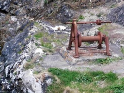
The forecast was for rain all day but as I walked along to Staxigoe it was the wind causing discomfort rather than the light drizzle. I used the shelter of a bus stop to weatherproof myself for the rest of the day. The little harbour at Staxigoe had all the usual features of an old herring port but there was also an unusual barometer pole from 1850 to help the fishermen gauge the conditions at sea, fairly bleak today.
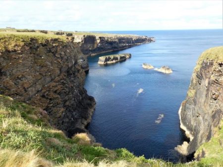
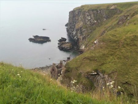
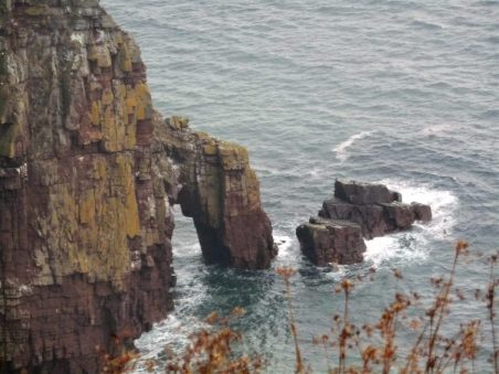
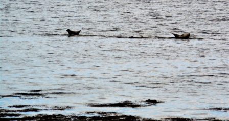
Walking on the road led to Noss Farm, the guide mentions a sign ‘Walkers Welcome’, it’s covered over – I wonder what happened? Some pleasant cliff walking followed, although the cliffs are much lower the scenery is still very dramatic. Grey seals lazed on the flat rocks and in the bay their heads were bobbing above the waves. A couple of geos were passed with small flat sea stacks.
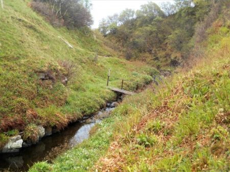
The way towards the lighthouse was across marshy ground with several varieties of orchids growing. No idea what they are.
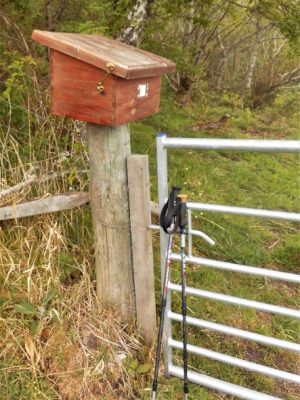
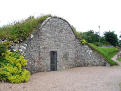
The lighthouse is still operational and has its own letterbox with a quirky sign, where else would you find this – must be a lovely community around here.
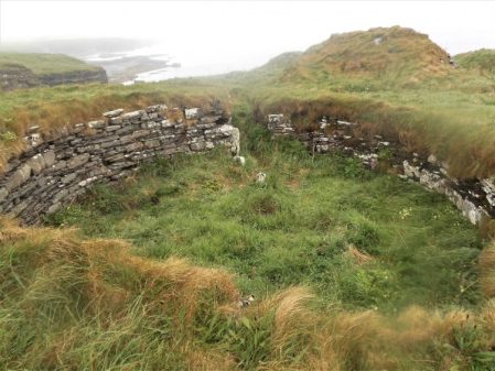
When I saw Castle Sinclair Girnigoe ahead the longer route was vindicated. An impressive and evocative structure in a stunning setting. It has a long and varied history as is common with these Scottish outposts. The powerful Sinclair family were residents from the early 14th century to the mid 17th century. By now the wind was bringing in heavy showers so it was head down across the fields to Ackergill Haven. Up the lane was a scattering of houses and what looked like a village hall, wondering about some shelter I approached the open door to find an active gym with people doing their stuff. It seemed incongruous out in this remote place.
Round the back the route was signed into a field containing inquisitive, nervous and sturdy cattle, I crept around an adjacent field.
I think these are whale bones, on a wall…
There was a private driveway leading to Ackergill Tower, a stately looking building possibly a shooting lodge, surrounded by high walls. I found a relatively sheltered corner with a picnic table, perfect for lunch.
At this stage I was still relatively dry but once out of the shelter of the estate buildings the way went onto exposed sand dunes. Ahead in the mist was a golf clubhouse and I had visions of hot coffee, alas all was locked – no golf today.
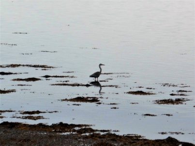
Pushing on I was able to avoid the taxing ups and downs of the sand dunes and walk along the beach, it was a long beach. The birdlife was different, waders at the water’s edge and terns flying overhead.
I came to the crossing of the River Wester and realised how deep and fast flowing it was on the beach made worse because of high tide. I was prepared to bypass it all together until a little inland the water was wider and I paddled across, I was already soaked anyhow.
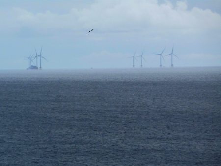
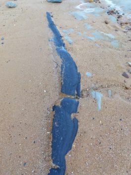
The next obstacle was the railway for launching pipelines into the sea.
At Keiss there is a small sheltered harbour and beyond it I could just make out Noss Head back across Sinclair Bay. One can imagine the relief of those fishermen when they returned from stormy seas to harbour. There is not much else here.
Appropriately my lodging is the Sinclair Bay Hotel, cosy and warm with some decent food and ale. The forecast for tomorrow looks grim. Sweat dreams.
I slept in. A relaxed breakfast followed so I didn’t set off till after 10am. There was no rush as it was drizzling slightly, I’d only gone a few fields when I saw a sign for Puffins. Sure enough on a small cliff near the path the little birds were arriving prior to nesting. I made my way along the narrow ledge to relish the experience.Along came the farmer who’d seen my approach, not to admonish me but to engage in good old honest chat. He had an interesting history and was full of information about the locality. Further up the trail as I walked inland he reappeared to take a picture for the JOGTrail Facebook page.
The next few hours were a delight on a mainly good path alongside the continually interesting coastline. Lots of large Geo’s to get round, sea stacks galore and the prolific bird life.
Ellen’s Geo.
Stack of Ulbster.
Sarclet Haven
Riera Geo
Riera Geo
At the massive Broad Geo I met a party coming southwards and found that their leader was no other than Jim, the new path warden, more conversation followed. This was a great spot for bird watching – I told you there was too much to see.
Mainly guillemots.
Razorbills
Broad Geo
A little further on and along comes the highest sea arch in Britain, the Needle’s Eye at the head of Ashy Geo.Off shore are a couple of hundred new wind turbines, I could just make them out.
I became lost once or twice on the broader, lower fenced areas, beware of your best waterproof trousers on the barbed wire fences.
The cliffs now are much lower but still show a diversity of geo’s, stacks and caves.
By the time I arrrived at Old Wick Castle my enthusiasm was waning. It is one of the oldest castles in Scotland, though originally built in the early 12th century by Norse kings who then ruled Caithness, it was well situated between defensive geos.
Minor roads through industrial areas, probably most connected to off-shore work. The harbour was busy, you can catch a boat to the Orkneys from here.
My simple b and b by the harbour had the steepest stairs up to the second floor, no pity on the weary.
Wick town centre was a little run down, but I managed to find a cheerful Italian for supper.
Accommodation – Harbour Guest House, 6 Rose Street.
*****
Out of interest here is the elevation profile for the day –
For this section the guide keeps mentioning to look back at the views – so I often did. A reminder that if the sea is on the right in my photos I’m heading North, if on the left I’m looking South.
Halfway through breakfast my landlady was called away by a friend who’s car had broken down, leaving me to fend for myself. On her return we put the world to rights so I didn’t leave till after 10.30 with a gift of two hardboiled eggs in my pocket. I walked down that main street like John Wayne, everyone stayed indoors.
The first stile just out of the village seemed to have been appropriated from a swimming pool. After crossing a small burn I was on the cliffs using a tortuous path, more of a narrow sheep trod. I realised that keeping within the narrow line made me walk like a catwalk model. The day was just clearing and the views opening up.
In the first large geo [sea inlet] was an abandoned building presumably related to the herring trade of the 18/19 centuries. The first of several small harbours and geos which all involved a considerable inland detour and descent/ascent to cross streams.
A disturbing sight alongside the fence was a tip of some farmer’s rubbish, where does he think it will go?
Once round White Head a stream had to be crossed between pretty waterfalls.
Back on the cliff top the roller coaster ride continued with lots of stacks and arches along the way. One of the finest stacks had a stone cairn on its summit implying an ascent in the past. Everywhere were birds mainly fulmars, kitiwakes, razorbills, guillemots and shags.
The long abandoned Clyth Harbour was a delight.
Back on slightly lower cliffs the path was easier to follow towards a disused lighthouse and it was here I saw a pair of Orcas, actually I heard their blowing first and then watched them swimming away only surfacing occasionally. Along this stretch were several skerries, low rocks off the coast, The rock strata here is much more horizontal ideal for drying cormorants and a diving shag.
Past the lighthouse I found a lunchtime stone, enjoyed the sun and watched the birds flying by.
Line Geo was spectacular and the cliff edge path getting round it equally so.The cliff ledges are home to thousands of birds, the noise is deafening in some of the geos. Kittiwakes, razorbills and guillemots.
Halberry Head was my next objective.
The massive Stack of Mid Clyth. big enough to be called a dependancy, is in fact a giant sea arch.
Another hairy crossing of a large geo on a narrow track. More sea stacks and and caves followed. This is possibly the best days walking so far and I was enjoyingmyself. More was to come in the next mile with Long Gate Geo showing outstanding hidden depths.
After that I was lost in gorse bushes and dropped too low down the cliff slope. My first attempt of climbing back up through the inpenetrable gorse led to retreat and a further detour that left me scrambling up the very edge of the deep Red Geo. I thakfully came out close to the A99 road. The final few fields seemed awkward, one final geo and I was glad to see ahead my lodgings for tonight. The famous Whaligoe Steps Cafe, though it looked uninspiring from the outside. The weather was just closing in as I arrived, I can’t believe I’ve only walked 7 miles, a lot has happened.
I was made very welcome by John and Edna and their two Highland Terriers, an Aswam tea revived me sufficiently to go down the 300+ Whaligoe steps to the original herring harbour in the geo. It was a quiet low tide and all was tranquility. I sat and was able to watch some of the birds at close quarters.
Fulmar.
Shag
Razorbills
Climbing back up those steps I thought of the women carrying baskets of herrings to the store which is now the cafe.
I awoke early and looked out onto the camping site, the backpacking lady had broken camp and was well on the way, never to be seen again. The eclectic international selection of camping vans were asleep.
The sea mist was in as I left the B and B and wandered down to the little harbour. In a shed there was a restored fishing craft used in these parts in the 18 – 19th centuries, the heyday of the herring fishing industry. Old pictures showed the harbours on this coast packed with these vessels. I can’t imagine going out to rough seas in one of these small boats. Further along was an old ice house for storing the fish.
The day’s climbing began up onto the first headland, the cliffs along this stretch were rugged and varied with sea stacks and arches. The path was close, often too close, to the edge giving spectacular views down. The walking was easier than the last two days and I made good progress with time to stare.
Further along where the path moved into inland fields the guide suggested walking on the road to avoid cattle. I was only too pleased to conform as I don’t like meeting bulls. The A9 was surprisingly quiet and I walked on for maybe half a mile then realised I was cut off from the coastal path by a high deer fence which took some precarious manoevers to overcome. I crossed a field towards the coast passing perhaps some ancient stones only to find myself up against another deer fence.
My climbing technique had improved and I was soon back on route on a much gentler, lower cliff top still with lovely inlets and stacks. The weather was improving and the sun had burnt back the mist.
I was now approaching Latheronwheel harbour and a few more walkers were out. A track lead down and over a surprisingly sturdy bridge onto the road which climbed towards the village. I took off at a bend to regain the headland with more sea stacks.
The next stretch of cliffs were grassy and apparently home to puffins but perhaps they haven’t arrived yet. There was a lengthy diversion inland to get over the deep Burn of Latheron.
Back on the open cliff tops there was a strange stone structure, not marked on the map, perhaps a beacon or lookout. I had a rest and snack on Robbery Head taking in the views up the coast and watching the birdlife. Looking back at the cliffs there were some amazing foldings in the rocks. There’s certainly plenty to see on this walk.
Robbery Head.
The day was moving on and there were still more ups and downs ahead. The next down was over the Forse Burn and then up to a headland with the precarious looking remains of the medieval Forse Castle. It reminded me of that game where you remove a brick without it all falling down – Jenga. Below was a beach with a ruined building, presumably related to the herring fishing. I was tempted to drop down to investigate when I met a mother with two lads who were going down using a fixed rope, it all looked very exciting.
There was an even steeper drop into the Achsinegar valley. Down here just above the sea were the extensive and evocative ruins of a herring processing station from 1810.
Rough ground followed below Swiney Hill. I found a seat and fine viewpoint above Lybster bay. Then soon I was above Lybster harbour, the last of the day, as a little boat came in probably from visiting lobster pots.
The main street of Lybster is far wider than most towns, nobody seems to know why.
A shop next to my friendly b and b provided supper. I’ve just found my first tick despite being extra cautious.
Accommodation – Bolton House B & B Main St Lybster
The excellent weather of yesterday couldn’t last and I spent most of today in drizzle, not that it mattered much as I was looking below at the cliffs and all the birdlife.
Yesterday’s bus driver welcomed me aboard for the short trip back to Berriedale,I was the only one alighting. I avoided the temptation of the cafe and made my way down to the harbour, I don’t think many boats tie up here. A bouncy suspension bridge crosses over to a row of cottages above the rocky bay. Proper ornithologists have their telescopes trained on the conveniently placed cliffs, I spot kittiwakes through my pocket binoculars but fulmars are also pointed out to me. The waves are crashing into the shingle beach.
A green path heads up towards a small cemetery but there I become lost in earthworks for another straightening of the A9, as if it is not fast enough already. My frustration is tempered with good views back down to the harbour. A bit of bashing through gorse soon has me back on track but on the wrong side of a fence which can create a problem.
Once on the clifftop I kept mostly outside of fences and walls – this was proper cliff walking – right on the edge. A good head for heights is useful in some places and I wouldn’t like to be here in a gale.
The Bluebells are late flowering up here and they give a colourful show with Pink Campions and Greater Stitchwort
In rough land there was someone’s private bird hide, I imagined the owners bragging at a cocktail party “oh we have our own private hide – don’t you?” It did have a fantastic view though. A little further just entering some trees was a box containing a signing-in book for the trail, only about 25 had done so this year.
Ahead the headlands were all a bit vague in the murk but here was my first sea arch.
Through a high cliff the Allt na Buaidhe stream tumbles in a spectacular waterfall, it was a bit short of water today.
I worked my way round to the valley of the stream where there was a new footbridge to cross. Strangely a path had been strimmed to the very edge of the falls, a every dangerous spot, Samaritans help number needed, but good views back to that small sea arch. You would have to lie on your stomach to look over at the waterfall – I didn’t.
The path to nowhere…
Moving on I was getting ready for lunch and spotted a stone bench, this turned out to be the perfect viewpoint for watching the birds on the An Dun headland and it’s massive arch.
I dont think I’ve ever seen so many birds, literally thousands on every ledge available. Mainly Guillemots and Razorbills. The latter are distinctive closeup.
The Kittiwakes and Fulmars tended to stay aloof.
After all that excitement in the next bay was The Cleft sea stack, it remained in sight for some time.
The going became difficult in long rough grass with only faint sheep trods to follow. However a group of sheep startled by me proceeded ahead creating a path as they went – a good idea for helping open up the trail.
Another stack appeared as I traversed high above the sea.
Diversions inland around Dunbeath Castle weren’t too bad how does this fit with the so called Scottish right to roam?
The gates to Dunbeath Castle are not overly friendly to walkers, a lot of these estates have been bought by rich foreigners who would like to keep the likes of us off the land. I didn’t get the feeling that there was much opposition to this denial of the right to walk wherever as allowed by Scottish law. Maybe time for a mass tresspass.
The old A9 entered the scattered community that is Dunbeath, everywhere was shut.
An old path goes down to the Dunbeath harbour from where there is have a steep climb to my B and B.
As soon as I was on my way this morning the familiar sounds and smells of the coast came flooding back. I was glad to be here though this is supposed to be the most arduous day of the whole trail.
A gentle stroll along from the harbour, just above the beach, and then at a ruin a sudden dog leg climb towards Navidale, a few houses and a cemetery. For the rest of the day I was well above the sea but it was ever-present. The Ord of Caithness was prominent ahead, I am in Caithness for the rest of the trail.
The most notable detail throughout today’s walk was the gorse, I have never seen it so brightly coloured before and in places I became heady with its coconut fragrance.
Easy walking through rough fields was tempered by the lack of waymaking on this stretch. Apparently some landowners don’t want markings but you are still free to walk across their land in Scottish Law. There were a few small burns to cross and then indistinct trods climbed gorse slopes to meet a more distinct track heading back down again. You could easily get lost hereabouts. Somewhere along here a couple of WW2 lookout huts were passed and waymark posts appeared. The Ord burn was easily crossed and then height gained steeply into the moorland of Ord of Caithness. Fairly random trails across damp moorland were followed almost to the A9 road and yet I felt a long way from civilisation.
The sounds of the sea were still prominent despite being well above it. Below was the green table, a flat promontory and site of an ancient fort. A secluded bay to its north gave an idea of the birdlife to come.
The green table.
Shags or comorants?
The ground became boggier but as there has been little rain in the last two weeks it was pleasant to walk on rather than troublesome. A burn was followed gently downhill past ruined buildings from the 19th century and a recognisable broch from the iron age with its chambered entrances.
Over the next steep stile the ground dropped away alarmingly into the deep ravine of Ousdale Burn. Attempts are in progress at building wooden steps but for now I was grateful for the trees I could swing off [opening photo]. Eventually down the burn was no problem as a bridge has been recently erected, there is a surprisingly large amount of new infrastructure appearing. I must make a donation to the charity responsible, I suspect a lot is a labour of love.
Of course it was steep up the other side of the ravine.
One came closer to the sea and seabirds were flying everywhere whereas before it was mainly smaller birds amongst the gorse.
Sheep trods weaved over the headland between the gorse bushes, a tough section. Then there were the ruined buildings of Badbea and there in front was the monument to honour the tough families forced off the land in exchange for more profitable sheep. Life at Badbea would have been harsh, many residents emigrated in search of a better life and the memorial commemorates many of them. A good spot for some lunch. Having seen nobody all day suddenly people started appearing from nowhere, well actually the close-by A9, all attracted by the ‘clearance village’ signs.
Through the gorse there was much bird song and I managed to capture a photo of a Brambling on the monument itself.
Easy walking on heathery tracks continued over the headlands, if not quite on the edge of the cliffs close enough to hear and see more seabirds. Inland were the Caithness hills with the conical peak of Morven, at 706m the highest, in the background.
Two towers, navigational aids from the 19th Century were useful markers today. They were aligned for approaching Berriedale harbour and used to carry lights, the Duke of Portland’s Candlesticks.
More headlands appeared ahead but I’d done enough for today. The harbour of Berriedale was below and dropping down to the A9 I headed for the renowned River Bothy tearooms for tea and cake whilst waiting for a bus to take me to my B and B in the scattered village of Dunbeath.