Monthly Archives: February 2018

SOUTH PENNINE RING – Todmorden to Sowerby Bridge.

When I was a youngster I would travel alone across the Pennines by rail to stay with an Aunt and Uncle in Manchester. A whole new world would appear to me as the steam train travelled down Calderdale, I have a long lasting vision of steep sided enclosing valleys, running streams and tall weaving houses with mullioned windows. All very atmospheric.  Well I was here again today –  stepping out of the train, albeit a diesel rail car, onto a platform deep in the valley.

Notices told me that Todmorden was Incredible-edible, an initiative focusing on local food and growing vegetables for the community. Throughout the town are plots planted up by locals with information on eating and crops to pick, well there wasn’t much at this time of year. An applaudable venture but I wonder how successful.

Everywhere was quiet as I slipped back onto the towpath in the town centre where there is a watering station for the boaters. Immediately there were boats, I should really be calling them barges, which had been conspicuously rare on the previous sections of the Rochdale Canal in the last two days. A basin full of lived in boats, alternative lifestyles are common in this valley.

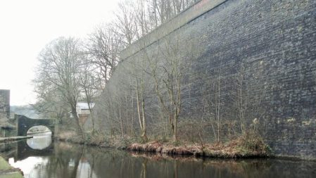
Many mills have been demolished and replaced by anonymous industrial sheds.

I caught a glimpse of Stoodley Pike high up on the moor but most of the day was hemmed in by the valley sides, it was bitterly cold when in their shadow.

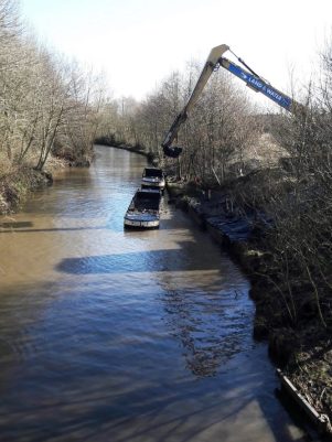
A canal barge chugged by with jolly occupants, the first vessel I’ve seen in motion. Obviously this area will be busy in the better months with canal traffic. I noticed there were several companies offering canal trips.The river Calder runs alongside the canal and severe damage was caused by the catastrophic floods of Boxing day 2015. A lot of repair work has been carried out in the intervening years.

Approaching Hebden Bridge are Stubbing Locks and Hebble Mill, the workers cottages here are classic ‘back to back’. Hebden Bridge’s centre is a crystals throw from the canal and is thronged with tourists visiting the new age emporiums. Thankfully I find a cafe on the edge, it turned out to be far superior to what its appearance suggested. Cool music, excellent coffee and tasty homemade quiche. Its long list of fancy teas betraying the town’s hippy roots. Back on the canal all was peace and quiet man.       Mytholmroyd was virtually bypassed.  It was the area where counterfeit ‘coiners’ operated in the 18th century, the industrial revolution brought many mills and foundries to the town and it was the birth place of Ted Hughes, the late poet laureate, whose early work was influenced by local nature. A cast iron statue by Kenny Hunter of a hawk  commemorates Hughes’ poem Hawk Roosting and has  connotations to the nearby Hawksclough Mill.        Sympathetically renovated mills and warehouses contrast with the sheds further on.       The canal continues with the River Calder alongside. In the area of Luddenden Foot there must have been vast mill workings judging from the amount of derelict land. A large complex of weaving sheds are being used for other purposes. The surrounding country side is surprisingly green and the canal is a popular recreational pathway in Calderdale.Approaching Sowerby Bridge mills crowd in and then suddenly the canal comes into a town centre car park where I mingled with shoppers. In front is the prominent parish church.The deep Tuel Lane Lock takes the canal under the main road on its way to join the Calder-Hebble canal – but that’s for tomorrow. That prominent Wainhouse Tower in the distance on the edge of Halifax is the tallest folly in the world. The nostalgic Jubilee Refreshment Rooms at the train station provided a good beer whilst I waited for my train.

A couple of extras …

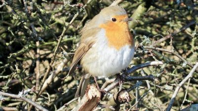
Don’t feed the birds.

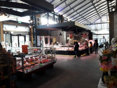
Good use of an old mill.                                                                                

***

As I write this the weather forecast for tomorrow is dire. Siberian winds bringing in snow, subzero temperatures and a significant wind chill factor. Maybe the east side of the Pennines isnt the place to be.

***


SOUTH PENNINE RING – Rochdale to Todmorden.

Three lovely  ladies were clearing litter from the tow path this morning.  They do it twice a week and there is always bagfuls.  To cover the optimum length they are riding bikes!       A Canal and River employee is also walking the banks checking for any problems. So it seems that this stretch is well looked after but why are there no boats? Apparently the locks this side of the Pennines are difficult to operate, some moorings are unsafe and there is often low water due to reservoirs previously being sold off. That all seems a shame considering all the work and expense to reopen the Rochdale.  The more you think about it the more audacious does the plan in the late 18th century to take water in a canal over the Pennines become.

Today’s walk had started by a side branch serving the town itself though only a short length remains. Close by is a fine bridge. A few more derelict mills and some housing developments  are passed and then the countryside is reached through bridge 56 with the Pennines in the background.

The inspection man.

This seems a popular stretch. Alongside runs the Manchester to Leeds railway with a boundary stone evident. The towered Firgrove Mill has workers cottages attached… … its redundant steam engine is in the Manchester Museum of  Science and Industry,  watch

Ahead at Clegg Hall there are some well kept former weavers’ cottages and a refurbished mill with apartments.I am heading towards Littleborough but my attention is drawn to a clock tower in the NW, it belongs to the closed Birch Hill Hospital which was built as a workhouse and opened in 1877. It had wards for ‘imbeciles’ and ‘fever’ patients, in addition to an infirmary block.The canal slides past Littleborough but I need a coffee so make the detour into a town bedecked with Lancashire red rose flags, maybe they don’t like being part of Greater Manchester. A busy little place and I find a great little cafe frequented by locals, Rebecca’s, for coffee and toasted teacake. Back streets lead me to the canal where new houses are being built.

I’m now heading for Summit the highest point of the Rochdale Canal by a series of locks in open moorland.There are bays where stone from the quarries was loaded and more mills, mostly derelict. I got chatting to a man who’d worked in Rock Nook Mill, originally a cotton mill but diversifying under Fothergills to high performance textiles.  A fire in 2015 devastated the mill and it now stands forlorn and open to the elements.An abandoned mill further up is unexpectedly the base of a theatrical scenery production firm supplying the whole country.

A few more locks and I arrive at the west end of the Summit basin at 600ft. At the top lock there is a lock-keepers cottage and then the canal widens and contours through rough moorland for about about a mile to the first lock going down the east side of the Pennines.The train line has disappeared into a tunnel.

Passing into Yorkshire 8 locks take the canal down to Walsden, whose church spire is prominent from a distance. The industrial landscape reappears with mills and weaving sheds canalside.

A little group of post war ‘prefab’ bungalows seem out of place. One of their owners, of a similar vintage, is proud they have lasted this long. Nearby are a couple of modern rabbit hutches – wonder how long they will last.At Gauxholme warehouses and boats appear and the canal passes under a cast iron railway bridge with Gothic abutments. More locks drop the canal down quickly passing back to back cobbled streets and then in front of you is ‘The great wall of Tod’. This massive wall of blue brick supports the railway high above, quite dramatic and hidden away from the rest of the world. How many millions of bricks? A Dipper, that iconic northern water bird, was passing up the canal, a Waterhen taking a lift on a plank and a Robin singing its heart out on this sunny day.

The canal entered  busy Todmorden at the main street with an abrupt guillotine-like lock dropping it down on its way, without most of the tourists knowing its there.. I had a train to catch so exploring the town will have to wait.

*****


SOUTH PENNINE RING – Manchester to Rochdale.

This was a 12 mile day full of interest with old mills coming at me thick and fast. The Metrolink tram took me to Piccadilly and I quickly found my way onto the canal basin where the Rochdale Canal emerges from the depths having already passed 9 locks since Castlefield. 3 years ago Sir High and I had braved these subterranean passageways on our Cheshire Ring jaunt.

Today my way was blocked by a locked gate meaning I had to retrace my steps and try again on the opposite side. The numbers on the bridges didn’t seem to tally with my map until I realised I was confusing lock numbers with bridges.  Not a good start, you shouldn’t get lost on a canal!

The Ancoats area of Manchester where the Rochdale Canal next passes through is known, tongue in cheek, as The New Islington because of all the new buildings many which utilise the old mills and warehouses in luxurious conversions. Marinas dot the developments. It is good to see this rather than dereliction, vandalism and demolition. The cranes are busy again with city centre living.

Some famous buildings are passed – Brownsfield Mill the old AVRO factory for aircraft manufacture;  the Royal  Mill a rebuilt 20th century cotton mill now under residential use, originally named New Old Mill a plaque commemorates a royal visit in 1942 and hence the name change;  the Beehive a former cotton mill connected with Sankey’s soap at a later date now earmarked for commercial use. There are many more. Names allude to the past – Cotton Fields, Coal Pits Lock etc.

But before long I’m back amongst average housing, urban sprawl and litter. The honking Canada Geese are everywhere fouling the towpath. Even the graffiti is not up to standard. But the sun is shining, there are few people about and I feel glad to be setting off on a new exploration.

To compensate there is the fine 19th century Victoria Mill canal side, a former cotton spinning mill. It was designed as a 6 storey double mill with a shared central chimney. Now office and residential use.

The next area is Newton Heath which had an industrious past associated with the canal – die works, bleach works, a tannery, rope works, glass works, brick works as well as the textile mills. A row of maisonettes is named after one of the young Man United players killed in the Munich air crash, 1958, I wonder if the other 7 are likewise nearby, I wish I’d looked.

I nip up a side street for a morning coffee with toast and jam in a basic cafe frequented by locals lingering over their fried breakfasts. Modest housing fronts onto the canal in contrast to the large Regent Mill whose brickwork is exquisite.It bears the names of Russell Hobbs and Remington and I believe they are still trading there.

Failsworth arrives with Aldi, Lidl, Tesco and KFC, the latter temporarily closed due to lack of chickens which has almost reached a national disaster according to some news outlets. The canal continue obliviously to pass the large Ivy Mill. This cotton mill was converted for aircraft assembly during WW2 and is now office space.A brief stretch of ‘countryside’ was passed through before the canal is squeezed under the M60 without a towpath, an elaborate foot bridge over the motorway reunited me on the other side heading for the Boat and Horses pub. A name recollecting the passage of hundreds of horse drawn cargo boats, it did not look inviting today having become a rotisserie and carvery for roadside travelers. The  nearby J.W. Lees Greengate brewery has produced real ale since 1828 and is still family run. I couldn’t pass through the area without sampling their product so at the next more modest canalside pub, Rose of Lancashire, I had a quick half. This inn opened in the early 1800’s as the canal was being developed and was a haunt of local radicals and reformers trying to influence parliament to improve the lot of the working class. The Peterloo Massacre 1819, in Manchester, was a defining moment in that struggle. The canal winds its way through the outskirts of Oldham with the railway a constant companion. This is the Manchester to Leeds engineered by George Stephenson and opened in 1841, I was to become well acquainted with its course in the next few days.  In the vicinity the railway crosses the canal on a beautiful cast iron bridge.

Over the River Irk, past the open spaces of Chadderton Park before more locks rise at Slattocks.

The next barrier is the M62 where the canal has been diverted under a culvert with an ingenious floating towpath. The original line is a boggy passage to the left. A lad was fishing for pike with a large lure which he expertly cast down the water. A previous fisherman told me that it was too cold for the fish, there was almost a layer of ice on the water.

The way into Castleton was enlivened by a cheery mural from a local primary school.

Just when you thought you’d had enough mills the massive Arrow appears. Cotton has given way to storage. I’m not sure how the canal goes under the M627 but I was diverted through retail parks to meet up with it for the last pleasant mile into Rochdale where I was accompanied by many dog walkers. Well the canal, despite its name, ironically doesn’t go into Rochdale but skirts the town at a discreet distance. Things have changed in Rochdale since the mills closed.

The train journey back on that line to Manchester Victoria only took 15mins.

*****


SOUTH PENNINE RING – A CANAL WALK.

I can’t get away from canals at present. Family duties will see me down in Manchester for a few days so I decided to look at this circuit which I’ve had on the back boiler for awhile.

The South Pennine Ring is a 71mile circuit north of Manchester combining parts of the Rochdale, Calder & Hebble, Huddersfield Broad and Narrow and Ashton Canals.

Completion of the circuit by boat has only been possible since 2002 with the restoration of the Rochdale and of the Huddersfield Narrow. Enthusiastic and dedicated pressure groups made this feasible but major engineering work was needed, particularly where motorways crossed the defunct system. Money came from many sources and various plaques reflect the Millennium  Lottery Charity funding.There are a large number of locks, needed to cross the Pennines twice, and the highest and longest tunnel [Standedge] in Britain. The original canals played an important role in the area’s industrial and weaving heritage. Several interesting towns are visited and  there are reminders of the past everywhere. Obviously the only canal traffic now is pleasure boats but the towpath gives the additional benefit of a long distance circular walk.

The Canal & River Trust was launched in 2012, taking over from British Waterways, to oversee    canals, rivers reservoirs and docks in England and Wales. Throughout the walk there will be much evidence of their work, aided by volunteers, to maintain this important heritage.


I had previously walked most of the Ashton from Piccadilly to Portland Basin three years ago.  So the plan was to walk the rest in a clockwise direction over a few days using my son’s house in  Stretford as my base, taking public transport at the beginning and end of each day. An economical and fairly practical way of completing the ring. This would be another step towards my fully fit walking rehabilitation since overuse damage to my left hip’s ligaments last year.

An excellent map is available –


MY ANNUAL SERVICE AND MOT.

“Your car will be ready about 4pm, we’ll phone you”

I’m in one of the outlets on the vast ‘motor village’ out by the docks in Preston where one can buy just about any make of vehicle. It was just after 9am in the garage reception area, more like a lawyers office than a garage but the mechanics must be hiding somewhere. Last year I took the opportunity to cycle round the Preston Guild Wheel but I’m limited to easy walking at the moment. The day was perfect, blue skies and winter sun.  I had to make the most of it so I planned on walking a 7 mile stretch of the Guild Wheel, its NW segment. But first a free coffee and a read of the paper – I had a lot of time to fill.

I knew from past experience that I wouldn’t enjoy the first noisy mile alongside the main road but as soon as this was crossed and left behind peace and tranquility returned. One’s mind becomes clearer and the rural calm helps with those nagging problems. The sun always helps.

I found myself on the Ribble Link which gives access at long last from the Lancaster Canal to the rest of the network once across The River Ribble. On a whim I decided to follow it towards the river but after a short distance and a couple of locks the the ‘path’ was too boggy for my trainers. As it is a new structure, 2002, there was no need for a traditional towpath. This link is basically Savick Brook which has been widened and equipped with locks to make it navigable. At a nearby bridge I watched some regular dredging going on and was able to chat about the Link with the Canal Trust workers. I have never seen a boat on this length before and wondered about its usefulness but they assured me 300 boats passed through last year.

Through the UCLAN sports grounds and  alongside housing at Cottam on maturing paths, dog walkers, pram-pushers, runners and cyclists all sharing and happy in the sunshine.

Soon one wanders into new developments appearing everywhere in north Preston like the pox. Their names are fanciful. They never come up with Muddy Meadows, Crowded Copse, Restricted View, Non-environmental Nook, Flooding Fields, Ruined Manor…

Broughton village however has recovered its relative tranquility since the long awaited by-pass has opened. The road is barely recognisable. Where’s the traffic queue? Probably somewhere else but they deserve a bit of peace for awhile.In a slower mode I noticed for the first time a stone ‘pinfold’ [where stray animals were held until collected] by the path and also a war memorial.

I walked on crossing the new road, named in honour of a local man awarded the Victoria Cross in the WW1. I was eager to see what has become of the cycle route along Durton Lane since the road works, again it is a changed world. There is no longer any through traffic but engulfing housing will eventually destroy its character.

A couple of snippets from this area …

The sign says No fly tipping.

Wouldn’t like to learn to swim here,

I let my phone guide me through the residential streets near the hospital and then on familiar ground down Plungington Road to enjoy a late lunch in my favourite south Indian cafe, RK Sweets. Vegetable thali for £5.

Rather than catch a bus just yet I wanted to put more miles into the lovely day so on I walked through the University area and past the international cafes of Friargate. What an opportunity to look at the newly refurbished market hall which though not yet fully running could give some life back into Preston city centre. I don’t come into town very often and I ended up in Wilkinson’s Camera shop spending money on an impulsive purchase of a replacement compact. Nearby was the bus station which is also being refurbished as part of Preston’s improvements.  The crowded bus dropped me a mile short of the garage so in the end I’d walked about 13 miles by the allotted 4pm

“Everything is OK and you’ve passed the MOT”     So all’s well.


A NOTHING DAY ON LONGRIDGE FELL.

The weather was ‘nothing’ this morning, from my house I could see a mist hanging over Longridge Fell. The exciting curling match on TV, GB v Italy, had me enthralled and delayed any outdoor activity.  As an aside a curling ice rink is being constructed up the A6, there aren’t many around and the Winter Olympics coverage should give it a boost when it opens. I hazard a guess that they had scheduled its opening to coincide better with the Olympics.

A late decision was made to get out and walk the roads at the western end of Longridge Fell. A dry circuit on tarmac but with some steeper sections than I been willing to do recently. I didn’t expect any views but wanted to build on my recovery strategy and put my hip ligaments to the test. They have been improving with recent flat walking and my resistance-band side stepping exercises. To that end I completed the circuit quite quickly and was pleased with the 700 ft height ascended. Job done.

The road goes up past the Golf Course where a little activity was taking place – the wall running alongside the road took my attention for awhile as I admired the shades of green – the road itself has suffered this winter and like most others in the area will not be repaired quickly.

The busy New Drop inn is at the cross roads, the walls of this inn carry a white cross insignia and history records it was previously known as the White Cross Inn. Why the change and I wonder what the cross signified? The road I’ve travelled is the old road to Clitheroe over Longridge Fell which avoiding the valley bottoms. Turning left I follow a straight road which I always thought was part of the Ribchester Roman Road over Longridge Fell heading for the Salter Fell road and on to Carlisle but a dotted line on the map  suggests the Roman Road was to the west of the modern road.

There was only a vague view of Beacon Fell from Jeffrey Hill where the Roman Road changed direction. More nothingness.

On the return leg back to Longridge I couldn’t resist a look into Cardwell Quarry. Climbing here was banned by the landowner a few years ago and he has refused to be persuaded otherwise. I was surprised that the rock was not completely covered in vegetation due to lack of use. The outlook from here on a summer’s evening made a visit worthwhile – maybe someday.

Down past the golf course once again and today’s modest road circuit was completed. That constitutes a ‘nothing’ day in my eyes.

***

 Did you know the Americans celebrate an annual  National Nothing Day on January 16th, [I had my timing wrong].  Monty Python characteristically  took the idea further with their Adventures of Ralph Mellish – nothing happened …..


A BLEASDALE BABBLE.

The streams coming off the Bowland Fells were babbling, full of water, and we babbled, full of air, as we strolled round the tracks. The walk passed by pleasantly with all the chat and we occasionally glanced at the hills which a few days before had been plastered with snow but were now in Springlike condition.

I persuaded JD, of Canary Islands GR131 fame, to accompany me, he was hankering for the open fells – give me another week or so. When I phoned him early morning, a perfect bright sunny and dry one, he had just returned from a morning gym session so I was doubly grateful for his company.

I have described in greater detail variations of this walk several times before. Usually done in the winter when it provides a fairly solid surface to walk on, particularly important in this season’s exceptional wetness. The farmer we met on his quad bike described it as the wettest he had experienced, we could only take his word for that.

At the start a few parapenters were soaring above Parlick and a little further we spotted four buzzards doing there own soaring on the distance.

We walked right round the base of the fells  Parlick, Fairsnape, Holme House and Hazelhurst past farmhouses where hill sheep farming has changed little over the years, then on through the Bleasdale Tower estate to emerge onto the road leading to Oakenclough. There were hazy views over the Fylde from up here, a good place for a spot of lunch in the sunshine. Whilst I chewed on my banana JD tried to figure out how to open his tin of tuna which turned out not to have a ring pull – ah well he is on a diet.

Road walking took us past Tootle Hall which I remember was once a homely farm cafe serving chicken in the basket with chips, ham and eggs or a substantial afternoon tea. In the area in those days several farmers’  wives supplemented their incomes with meals in the family dining room. [There is one remaining in Ford Lane, Goosnargh – The Cottage. Go there soon if you wish to recreate eating out in the 60s and 70s. Its all gastro pubs now.]

Walking on past that wonderful beech hedge and we were back at the car within 3hours. A perfect babble and one I will no doubt repeat many time in future winters.

                                                              *****

BLUE PLAQUES IN LONGRIDGE.

How to make the best of a sunny afternoon whilst I’m not able to climb the fells?

I have had in mind for some time a walk around my home town of Longridge visiting the buildings bestowed with a blue plaque. A quick piece of research of Longridge Heritage Committee information told me they had placed 15 in total – so off I went, camera in hand.

I intend to let the plaques give you the history whilst they are legible …

No 1. CRAMPOAKS MILL.

At the bottom of the main street, Berry Lane, is Booths Supermarket. From the front it could be any retail outlet but viewed from the side the telltale ‘saw tooth’ north-facing roof lights marks it out as an old mill, there were many such cotton mills in Longridge, spinning and weaving.           

No 2. Youth centre.

Across the road on the corner is an undistinguished building housing a community and youth centre with several notable past uses including the Bond Minicar developed in town.

No 3. The Towneley Arms.

A popular local pub situated next to the old station. An adjacent level crossing was used on Berry Lane where the line crossed to sidings for the mills and on its way up to the quarries.

No 4. The Old Station.

The station has been sympathetically restored as a Heritage Facility and a popular central cafe utilising the platform space as well as the station building. There is always a wealth of local information available in the heritage centre. Searches on the internet will soon provide more history on the Preston – Longridge railway and its unique branch to Whittingham Hospital which in its heyday was one of the largest Mental Institutions in Europe.

No 5. The Co-operative Building.

On the next block up is another imposing stone building previously holding our co-op. When I first arrived in town I would shop in the various departments of the large store. The plaque mentions the ballroom upstairs but I mainly remember the Polash Indian Restaurant up the stairs when the space had been divided – good old Ronnie was an excellent chef and I still have contact with his family in Burnley. The present co-op store has moved to a new building next door and the lower floor shops are now charity and betting – a sign of the times. The rest of the building is however used as semi affordable flats. Shame they didn’t restore the clock which is visible from most of the lane.

No 6.  Methodist Church.

This Wesleyan Methodist Chapel is now in private ownership having been sold off and the congregation incorporated into the United Reform Church down the road – now the thriving Christ Church. Needs must. I have never been inside it.

No 7. The Stone Quarries.

I hit a problem here – I couldn’t find the blue plaque! I presumed it was by the tunnel linking the railway to the quarries. In the past the railway line continued from the town centre through what is now John Smith’s Park and connected with a horse drawn incline up into the extensive quarries, Tootle Heights, producing high quality stone for many construction projects in the NW. Liverpool and Preston docks and many public buildings in Preston. The raison d’ètre of the line.

Tootle Heights Quarry in its heyday.

No 8. The Quarryman’s Arms,

Just below the quarries is this old pub building – now my favourite Thai restaurant.

No 9.  Club Row.

Walking back down Higher Road you come to a row of cottages on the left. They have an interesting history.

No 10. Cinema.

Unfortunately the cinema is under scaffolding at present, undergoing refurbishment with new owners who hope to continue operating it as private cinema. It has been a unique experience with ice cream usherettes, tea and coffee in mugs and the National Anthem, lets hope it continues to be.

Its noticeable how many properties in the old parts of town were previously involved with  hand-looming.

No 11.  Fell End.

Continuing down the hill there is an old building, now a funeral parlour, on the corner bearing the plaque. The Duke William pub opposite is now private housing.

No 12. St. Lawrence’s Church.

Opposite across the main road is the parish church in a prominent position approaching the town.

No 13. New Town.

Round the corner on the busy Preston Road is an area known as New Town which is now a conservation area. The water pump has been restored. As a bonus here we get a Red plaque.

As it was…

No 14.  Stone Bridge.

The busy roundabout at the end of Preston Rd is built on Stone Bridge where the railway entered town. Not the most salubrious environment – don’t hang around.

No 15.  St. Wilfred’s Church.

The prominent church further along Derby Rd is Roman Catholic, an important religion in the town.

So a walk of about 3 miles has included all the plaques but there are so many more interesting stone buildings in town that I feel I could produce another circuit.

LANCASTER CANAL 8. Sedgwick to Kendal.

For our last day the sky was blue, the ground hard with frost and the surroundings covered in snow – magic. Of course this was all planned.

We were soon back up to the line of the canal and making good progress through the fields on the edge of Sedgwick which seemed to have some pleasant housing tucked away from modern hectic life. The village first enlarged due to the nearby gunpowder works on the River Kent, subsequently residential properties have been built in what was probably the estate of Sedgwick Hall mentioned in my last post. The canal crosses a road on a skewed aqueduct in the middle of the village, these were built for strength.

Lovely countryside was traversed with drumlins to our right, isolated bridges and then woodland giving variety.

Looking to the east above St. Marks Church in Natland was an attractive Fell I didn’t recognise, looking on the map it is named The Helm and has an Iron Age Fort [Castlesteads] at its southern end. Yet another place to explore on a return visit.

Onwards under more isolated bridges with the lower Kentmere fells  in the background. This area is well walked being just a stroll out of town.One can see why Kendal is a popular place to live – a lively historic town in beautiful surroundings.

And then we were into the streets and parks of Kendal, the line of the canal still walk-able with frequent signs. A walking cycling corridor out of town. Passing behind the leisure centre the site of old coal wharves has been utilised by local schools to provide environmental studies. 


One renovated bridge had iron work alluding to the history of rope-making  hereabouts.

A crossover bridge is encountered and duly crossed, there have only been three on the whole of the canal. Obvious old mills are passed, the castle is up to the right somewhere. More filled in wharves at Lound, with informative interpretation boards,  and then the main terminal basin is reached, now only identified by warehouses. These are now used for other purposes though some have links back to the past. A small building is signed as being the original ticket office for the packet passenger boats. In the last warehouse, now modernised, is the head quarters of Gilkes manufacturing turbines on this site since 1856. Apparently inside are some original features of the basin.One can only imagine the industry and flow of goods right in the centre of Kendal in the 19th century. A return visit is needed to explore this industrial heritage further.

Below is an old aerial shot of the terminal basin [Stricklandgate House Trust]


Our way across Gooseholme Bridge was closed due to flood damage, so we braved the traffic on a road bridge to reach Baba Ganoush for a welcome bowl of delicious soup. This was followed by the three of us ‘running’ to catch the 555 bus, thanks to the driver for waiting for us.

So my journey up the canal from Preston is completed. It has been a very pleasant stroll helping my hip ligament rehabilitation but more than that has been full of interest and kindled my desire to explore this area further.


LANCASTER CANAL 7. Holme to Sedgwick.

We were the only ones stood waiting for a bus on the deserted slip road off the busy A590 roundabout but sure enough the 555 appeared and took us back to Holme and bridge 149 on the canal. Driving up the motorway this morning the snow covered Lakeland mountains looked majestic, blue skies and bright sun promised a good day – on the Lancaster Canal not those mountains.  I have just realised we are now walking in Cumbria so ignore my tagging of Lancashire, somebody moved the boundaries.

Today’s stretch is along isolated truncated parts of the canal which in its demise suffered at the hands of the road builders, notably the M6. Despite this there were some beautiful stretches of countryside as well as awful noise from the motorway.

The start on the edge of Holme is dominated by Farleton Fell to the East. we could trace defunct tracks used to bring limestone down from quarries to the canalside basins. Over to the west the cliffs of Whitescar were prominent with the Coniston range behind. Soon the canal was blocked by the M6. A diversion through fields alongside the motorway to a crossing meant backtracking, for the sake of completeness, to the point where the canal emerges from a culvert under the road. Swans were starting to nest build on this watery cul-de-sac. I recall the kingfisher that flashed past somewhere back near Galgate, haven’t seen much else but ducks, oh and the odd Heron.

Through Farleton remains of one of the stables used for the ‘fast’ packet boats was passed, horses were changed every 5 to 7 miles to maintain momentum. Remember, as the cars speed by on the M6 and trains on the nearby main line, the 57miles from Preston to Kendal took passengers 8 hours. The industrial haulage was more like a week for the round trip.

A little further on and there was an aqueduct over Farleton Beck, I dropped down to view the structure and found what appeared to be a fish ladder next to the beck, but I think is just an overflow from the canal.  Notice the first use of beck, a Norse word for stream used mainly in the north of England.

Another stretch by navigable water ended at a culvert under the A65, we used the underpass and again a short while later at the M6 again. There is no way the Northern Reaches of this canal will be restored. History is littered with bad, short sighted planning decisions. We are still making plenty of them unfortunately. In between on the short section of canal swans glide regardless of the situation. 

From here on to Stainton the canal is navigable if you can get a boat into it. The only craft we saw was the Lancaster Canal Trust’s small boat moored at Crooklands. The main canal feeder from Killington Reservoir enters, disappointingly as a mere trickle through a fence bordering an industrial unit. Killington Lake is known to many for its M6 service station on the way south. Up to 17 million gallons of water a day enter the canal here!

There is an aqueduct over the Peasey Beck which supplied the gunpowder factory mentioned below and is interconnected to the Killington supply. In the vicinity we passed a canal side coal wharf and the larger Wakefield’s wharf which was connected by a tram-way to a nearby gunpowder factory at Gatebeck, yet another place to explore. Saltpeter and sulphur came from foreign lands but the charcoal and water power were local.

Wakefield’s Wharf.

Lunch was taken at the Canal Trust’s restored packet stables but was interrupted by a short hail storm  on an otherwise sunny cold and clear day. Looking back on our meandering route Farleton Fell looked surprisingly close.

The section northwards was through glorious English countryside and would be a joy to canoe.

Another small feeder comes in and then an aqueduct over Stainton Beck. Storm Desmond two years ago caused serious damage to the stonework and repairs will be costly.

The semi functioning canal finishes  finally at a damn where the water no longer exists. The next length of canal, optimistically named First Furlong, is being cleared and re-puddled with the hope of returning to water. But a few volunteers will be no match for the hundreds of navvies working two centuries ago.

A dry section can be followed to the entrance to Hincaster Tunnel, the only one on the canal, When built to go under the hill there was no towpath so horses had to be taken over on the path we now follow. There is much interesting stonework associated with the canal structures here and the modern railway goes overhead. How often do the railways parallel the canal? Down the otherside is another packet stable.

A short stretch by the dry overgrown canal course is made interesting by installations of models, figures and other artifacts introduced no doubt by some local children who may have been involved in the clearing of the ‘towpath’. A nice touch much appreciated.

The canal has been demolished by the A590 and a lane is taken. Below is the estate of Levens Hall, which is well worth exploring. A short climb brings us up to the course of the canal, now in filled, and a field crossed to the obvious isolated canal  bridge,177. We are above the interesting Gothic like Sedgwick Hall which was previously a school and now converted to individual living accommodations.

Our car is not far away leaving us a short section of ‘canal’ to complete into Kendal.

Corniest boat name of the day category. We only saw one boat all today … Waterwitch, it will have to do.