As I write this today, with the rain coming down, yesterday’s welcome sunshine seems a distant memory. After several Lancashire walks taken directly from a guide book it was time to visit a different area and plan a route for myself in hopefully contrasting scenery. It worked out better than expected.
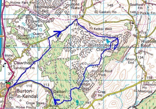
We were up the motorway out of Lancashire and into Cumbria, but only just. Not the Lakes but a quiet corner hidden away in the extreme south of the county. In the past I travelled here often to climb and boulder on Hutton Roof crags, beautiful sculptured limestone in the exquisite landscape above Dalton. It was time for a revisit and going over the map the night before I came up with a circuit including the summit trig point which I had not knowingly visited before, my focus then being primarily on the climbing area. It’s complicated up here with several ‘rakes’ of rock running across the fell, presumably fault lines in the limestone, creating miniature walls of rock. Paths are everywhere, but don’t always go anywhere and once the bracken is up it’s like finding your way through a maze.
I phoned Mike at a respectful time in the morning to see if he fancied a walk, but he was due to visit family on this Coronation weekend. Maybe I should therefore go for a longer walk in Bowland? Before long however he phoned back to say he thought, taking advantage of the good weather, he would postpone family to another day. I outlined my planned walk with only vague ideas of how we would navigate across the limestone plateau. Sandwiches hurriedly made we set off.
It was almost noon when we parked up in Burton-in-Kendal, but this worked to our advantage as the misty morning had given way to bright sunshine and blue skies. The first pleasant surprise was the old bridleway, Slape Lane, leading out of the village. A Panoramic Viewpoint has been erected to honour Queen Elizabeth’s Golden Jubilee in 2002, the distant Lakeland Hills depicted were unfortunately hazy in reality. At least closer at hand Farleton Fell appeared prominent. 

Between hedges and walls the bridleway snaked slowly up the open fell side, first through farmland and then into forestry. Our attention was taken with the spring flowers and the unidentified bird song in the trees.


Cumbria Wildlife Trust seem to have a hand in managing the woodlands and provide helpful information boards and permissive paths going who knows where. We stuck to the bridleway which came out onto a short stretch of road leading to a col where the Limestone Link footpath crosses Farleton Fell on its way from Kirkby Lonsdale to Arnside or vice versa. Nearby Newbiggin Crags look worthy of exploring.


Turning right we followed the footpath through coppiced woodlands and then onto more open limestone fell. Purple Orchids sporadically appeared giving a splash of colour. What a place for our lunch, looking out over fertile farmland and farther into Cumbria and the distant Howgill Fells. 
I knew, or thought I did, my way to the climbing area, marked as The Rakes on the map. Soon we spotted climbers along the edge. Most were doing roped routes, and we stopped to watch for a while – what a perfect afternoon for them. Can you spot South America? 


Now for the difficult bit. There was a path leading away from The Rakes which I thought might take us to the trig point, but it kept going down. Trying to make a straight line back up the hill was impossible across the shrub covered limestone blocks. Not wanting to break a leg we surrendered and back tracked on the path we had come in on. This brought us back to our lunch spot! I glossed over this by praising the weather and suggesting to Mike it was good training for him, he’s off to the Amalfi Coast in a couple of weeks. We struck off on a higher path heading in the right direction only to find it twisting and turning through the rocks. Forward visibility was obscured by the vegetation, one just had to keep going the most obvious way. Junctions caused some serious discussion, but we might as well just have tossed a coin. A runner appeared coming in our direction, on asking him if he had come from the trig point he looked baffled obviously not recognising the term. Onwards. A well-used path came up from the valley, so we joined it. A couple of dogs came past us followed by their owner who gave the impression of knowing the way but in fact this was her first time too. We followed the dogs and suddenly came out on to the more open top with the summit trig clearly visible.


A true 360 degree viewpoint, now with Ingleborough coming out of the cloud. The Bowland Hills were clearer than the Lakes. Morecambe Bay was a silver shimmer and one could see Blackpool Tower through binoculars if you wished. I don’t seem to have taken may picture at the top. It would be worth getting up here early one morning in the crisp air to make the most of the visibility. And what sunsets you could witness. 

If we didn’t get a move on we might have been seeing one of those sunsets. But once into Dalton Hall’s woods the forest tracks lead us unerringly down to a lane through the few houses of Dalton and down eventually to Burton. 
It was 6 o’clock back at the car – oh well I could forget about cutting the lawn.
What an exceptional walk this turned out to be. On reflection, I see on the map public footpaths from Dalton that would have taken us to Burton without the road walking, maybe next time as I’m sure there will be a next time.
***



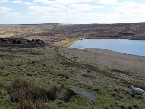


 I couldn’t resist a decent hill day as the weather remained fine. All change next week. ‘Head east old man’ was my mantra as I sped along the M65. Everyone else was going west to Blackpool or the Lakes. Boulsworth Hill my objective. So far so good, but the last chapter of Mark Sutcliffe’s Lancashire Cicerone guide would have had me parking above Wycoller. If there ever was a honeypot then Wycoller deserves that title. A secluded village of agricultural and hand loom workers in the C16th to C18th. Along came power looms in the C19th in nearby Lancashire towns and the population moved out. By 1896 the majority of people had moved away from the village, and it was virtually deserted. But a renaissance occurred in the mid C20th, the area was incorporated into a Country Park and people started moving back into the village renovating the properties. I well remember Longridge acquaintances of mine telling me of their plans for one of the houses in the 70s. I suspect you would have needed a bottomless purse to go ahead. For more information look at


 A good start to the day, although by now it was after noon. The expected crowds were milling around in the hamlet. Crossing and recrossing the series of


 I have a few ideas for some hilly walks now the weather has improved, but they would involve travelling on the busy Easter roads, so I manage to procrastinate the morning away. Let’s just stay local and have a wander up Longridge Fell checking out a few bird habitats at the same time. I’m keen to see the Great Crested Grebes performing their mating dance on the little reservoir at the top of the village. This is where I park my car. Craig Y Longridge is busy with climbers.