ROMBALDS MOOR – STONES AND POEMS.
25 Replies

Eden Benchmarks are a series of ten contemporary stone sculptures located at intervals along the length of the river Eden between its source above the Mallerstang valley and Rockliffe, north of Carlisle, where it runs into the Solway Firth.
“Each sculptor worked in residence for six weeks and this enabled them to formulate their ideas by familiarising themselves with the locations and talking with local people, including schools, who were encouraged to visit their workshops to see the sculptures taking shape. The artists’ brief allowed as much creative freedom as possible to produce site-specific sculpture, which harmonises with the landscape and captures the essence of each unique locality.
Collectively the sculptures give visual expression to our awareness of the river’s ecology and the need to look after it; individually they foster a profound sense of place, their capacity as seats accommodating an interactive focus for quiet reflection.”
These sculptures were funded and commissioned by the East Cumbria Countryside Project group in 1996. It disbanded in 2008 when funding dried up, but the sculptures are still there even if not officially cared for.
I have already discovered the first two in the last couple of days, ‘WATER CUT’ in Mallerstang and ‘PASSAGE’ in Stenkrith Park, Kirkby Stephen. Today I intended to visit as many of the remaining eight before I ran out of daylight. It would mean more driving than walking, I had plotted a route down the Eden between all the village sites. The satnav on my new phone proved invaluable.

I’d enjoyed my two nights at the Black Bull in Nateby and they sent me off with a hearty breakfast, I didn’t eat again until I was back home in the evening. I stopped briefly in Kirby Stephen to take that photo of Lady Anne Clifford’s statue which I used yesterday. I noticed this seat with its friendly notice, I didn’t have time for chatting but what a good idea. As the benchmarks have all been sculptured to provide a seat to sit and contemplate this was a good start to the day.
A mad dash up the scary A66 and I was taking the road into Appleby. A little side lane, Bongate, lead down to an old ford over the Eden by a derelict mill and a small carpark. At the edge of the carpark was a rough looking boulder – could this be the benchmark? It was only when I walked around the other side of it that I could see fully the carved flower. I brushed the leaves aside and sat in it for awhile watching the river flow by. Stunning.
“Shaped from a nine ton block of St Bees Sandstone, the Primrose Stone magnifies the ‘inscape’ of the much loved first rose of spring. As you approach the sculpture from behind it looks like a rough erratic boulder and the carved petals of the flower at the front come as a surprise. It envelops the sitter in a bowl shape that is positively seductive and, like a primeval satellite dish, amplifies the sights, sounds and smells of the river”.
Joss Smith lives in London. His work is mainly studio based and traditionally figurative but has recently been making accessible sculptures for public places.


*
I needed more time to explore Appleby but I was soon on the way farther north. I found a bit of roadside parking by the cricket pitch on the outskirts of Temple Sowerby and strode across muddy fields towards the river. You can see the state of the ground after all the heavy rain. The sculpture came as a surprise with the spheres scattered over the surface ripples. There was a distinct feeling of motion as the spheres ran into the river. I loved the ripple effects she had created around each grain.
“The stepped slabs of Lazonby Sandstone in this sculpture represent the contours of the landscape and its light, shade, pattern, shape and form. The spheres, reminiscent of gigantic pebbles in a fast moving stream, are a powerful evocation of the river and its energy but also, like hugely enlarged grains of sand, recall the origins of sandstone in the shifting sand dunes of Triassic Cumbria”
Victoria Brailsford’s work relates to ecological issues and ranges from charcoal drawings to wood carving and large stone sculptures. 


*
Back across the boggy fields and reset the satnav for Edenhall, a tiny red sandstone hamlet across the river from Langwathby. I park in a small pull off and ask the couple on the adjoining garden if I’m OK there. They don’t see many strangers in the village and I explain my mission. They are proud of their nearby Benchmark and regale me with their favourites, they haven’t made it to the Water Cut in Mallerstang as yet. I leave them to their pond maintenance and walk down the lane towards the squat red sandstone C12th church. I turn off at the wheel headed cross, the base looks ancient but the shaft as is often the case much more modern, There used to be a manor house down here which explains the churches isolated position surrounded by parkland. It also explains the name of the river bank walk I was about to set of along – The Ladies Walk. Built for the manor house occupants, a level path above the river with old iron railings and stone seats at intervals, fit for a lady. Not sure how far along I would have to go, met a bloke walking the other way but he knew nothing of Benchmarks. Up some steps and there is the sculpture. Two curved pieces of red sandstone in juxtaposition. They have graceful curving lines and wonderfully detailed surface rippling. The low lying one is being gradually covered by green moss and for a moment I think of cleaning it to reveal the detail, but I stop myself in time. These sculptures were specifically envisaged to reflect the landscape and now I feel they are slowly becoming part of it. That is probably hidden praise for the sculptor’s skill in the first place. I was warned that the ongoing path was flooded so I turned tail and followed the ladies alongside the ever enlarging river.
“Made from Lazonby Sandstone, ‘South Rising’ pays tribute to a vigorous ecosystem, representing the river’s perpetual journey and the annually recurring movements of migrating fish and birds. The horizontal stone alludes to the river itself, flowing north, and the tall vertical stone, with perhaps a passing resemblance to Long Meg, inclines south toward the rivers distant source. Chiselled with a surface texture reminiscent of water reflected sunlight, both stones have been carved in sweeping curves like the surrounding landscape, creating a rhythmic energy passing from one to the other”
Vivien Mousdell trained in ceramics but switched to wood and stone carving and letter cutting. A skilled and versatile artist she has specialised in public commissions such as the stone boundary markers on the Cleveland Way and a variety of wood carvings on the Whitehaven to Ennerdale cycle path. She is also a puppet maker and performer and video artist. Some people are just so talented.


*
Straight up little lanes in picturesque scenery, through Great Salkeld, I need to visit Long Meg and her Daughters on the other side of the river some day. Down there by the river are Lacy’s caves, chambers carved into the soft sandstone, which I distinctly remember from my Eden Way walk all those years ago. There was also an excellent climbing crag which is unfortunately now banned. Public footpaths and access are at a premium along this stretch which is a disgrace. The Settle-Carlisle line comes through the middle of Lazonby, I duck under it and head for the riverside picnic area. The Eden is in full flow. In rather drab surroundings the next benchmark lies low in the grass, can you spot it? 

This one really is becoming organic. Moss is taking over and obscuring most of the stones’ cyphers. I see the sun or is it moon at one end and that’s about it. I do like the view up to the graceful bridge though.
“The sculptor presents us with a series of puzzles to be decoded. The combined stones mimic the river landscape and contain various references to human history. A sun and moon have been carved at one end of the sculpture representing the winter solstice and a variety of images are portrayed elsewhere, including a fish, a Roman 1996, a Celtic horses head’ a rams horn and decorations taken from a Norse tomb”
Frances Pelly lives in Orkney. As well as carving stone she also works in bronze. 


*
Where next? A short drive along the valley to another delightful village, Armathwaite. This a spot I know well having climbed on the riverside crags many happy times. I parked at the bridge and walked through the grounds of the Fox and Pheasant and up into Coombe Woods on a carpet of leaves until quite high above the river and the crags. The path leveled out and there was the carved block in a ring of smaller stones. I could easily pick out the intricate carvings of discarded clothing from the bloke who has gone for a swim. What an imagination, the sculptor’s not mine. I found a lower way back closer to the roaring river. A magic stretch of water.
“A solitary walker reaches a plateau in Coombs Wood where beneath him, between the trees, he can see the winding river Eden. Nine stones form an ellipse in clearing. It is a hot day and he removes his clothes and goes for a swim. This sculpture is about walking in the countryside and being at one with nature. The largest of the stones is carved with representations of various items of clothing and a map, which also functions as a sundial. A tiny face depicted on the cap is reference to a series of faces carved on the cliffs below in 1885 by William Mounsey who famously walked the length of the Eden”
Graeme Mitcheson lives in Derbyshire. His work is based in traditional stone masonry and he turns his hand to everything from commissions for bird baths and garden ornaments to architectural restoration and memorials.


*
An easy drive and I was parked on the village green at Wetheral near the church. It was just after one o’clock and for the first time I thought I might make the Solway today. A steep little lane took me down to the river and there was the next sculpture on a flat piece of land. This was a large affair, a bench with angels’ wings, cushions and arched panels reflecting the nearby bridge.
Tim Shutter is a master stone mason in the classical tradition. He is based in London.


Back on the village green I became distracted by some tiny yellow fungi hidden in the grass -possibly Golden Waxcaps? There’s beauty in the minutiae too. 
*
I was apprehensive of my detour into the centre of Carlisle for my penultimate benchmark. I new there was some parking near the castle so I asked my phone to take me there. It was clever enough to warn me that “the castle may be close today” Despite the heavy traffic delays I eventually arrived in the car park but couldn’t understand how to operate the pay machine. Two ladies took pity on me and as they had just finished their shopping spree gave me there still in time ticket. I felt the day was slipping away with these delays. 
I walked towards the river only to find another car park without charges, the dog walkers used this one. Somehow rivers either bring a city to life or become subjugated into the background. The river Eden in Carlisle is of the latter character – lost between rail, roads and industrial sites or maybe it was the dullness of the afternoon that prejudiced me. The four stones were set in a line in the parkland alongside the river. Strange angular carvings which didn’t relate easily to me, erosion usually produces smoother features. OK they are smooth on one side but I find the other angles jarring.
“The four components of this sculpture are manifestations of the sculptor’s intense and mathematical explorations of the stone itself and, almost incidentally, describe a sequence of water eroded stone running parallel with the flow of the river nearby”
Hideo Furuta sadly died in 2007 aged 57. He was an artist of international standing and was based at a granite quarry in Dumfries and Galloway. 


*
Maybe I was a bit harsh about Carlisle as I know from my trip on the Hadrian Wall path that the Eden is in magnificent form either side of the city. Anyhow I was pleased to find an easy way out of the city to my last destination, the village of Rockcliffe on the Eden before it slips into the Solway.
The clock had turned three and the light was fading and I couldn’t find anywhere to park. I eventually used the carpark of a nearby pub and walked on down past the church to a little red cliffed bay area next to the river. Flood debris showed that it is often underwater. At the end I could see my final benchmark and thankfully it was a thing of beauty reminding me bizarrely of the amoebae I used to study under the microscope. How does the sculptor achieve such smoothness and shapes out of a block of sandstone? My only thought is that it could have been positioned closer to the Solway estuary itself but there may have been practical reasons against that. Here I saw the river slipping around the corner into that unseen estuary. I found a place to sit inside it and watched the sun fading in the greyness over the flat marshlands.
“The title of this sculpture is indicative of its global perspective. Situated where the river Eden flows out to sea there is an expanding awareness of the wider world. It could simply be a huge sea creature washed onto the shore but it conveys the sense of an even bigger scale. There is a mysterious pregnant silence about it and it resembles a planet earth held carefully in a hand. The term global warming is now ominously synonymous with the world overheating yet we would like it to mean a nurturing, life enhancing glow”
Anthony Turner was born in Kenya. A self taught painter and sculptor. Recalling his childhood in Africa his sculptures are organic, exotic and sensual.


*
What a journey. I didn’t expect to reach all the Benchmarks today but time just seemed to flow for me. You must admit these sculptures are so impressive and yet so diverse. At each one I felt a strong connection with the artist, the stone and the setting. It is too late for me to rewalk the Eden Way but wouldn’t that be a finer way to appreciate the river and take in these works of art.
I’m back home after an easy motorway journey from Carlisle and preparing to visit my cousin and her husband down in Derbyshire. In the past I have shared walks with him but now he has advanced dementia and is bed bound. Maybe I’ll show him some pictures of the River Eden.

Time to head into the hills. After a good breakfast I was ready to be away fairly early from the pub. Interestingly the garage opposite had more farmers’ quad bikes in for servicing than cars. 

Refueling.
It was a short drive up the valley into Mallerstang proper. On the way I passed the ruins of Pendragon Castle. The early morning light was so clear that I made a quick photographic stop in case things were murkier when I returned, it starts getting dark between three and four.
There is a lot of legend associated with the castle. it was supposedly built by Uther Pendragon, the father of King Arthur. It is said he tried to divert the river to form a moat.
A well known local couplet goes –
Let Uther Pendragon do what he can, Eden will run where Eden ran.
The castle was built during the reign of King Rufus in the 12th century by Ranulph de Meschines, After attacks by Scottish raiders in 1541 it became uninhabitable until the C17th when Lady Anne Clifford inherited it. She rebuilt it and added to it in 1660. It remained one of the favourites among her many castles until her death in 1676 at the age of 86. She spent her time between Skipton Castle and here in Westmorland becoming involved with local affairs and restoring several nearby churches. A long distance walk tracing her travels passes this way. There is a statue of her in Kirkby Stephen market place. 
Her successor, the Earl of Thanet, had no use for the castle and removed anything of value from it, By the 1770s much of the building had collapsed. It now stands as a romantic ruin with pointy Wild Boar Fell in the background. 


Whilst wandering around the ruins I was treated to a flypast by a Lockheed Hercules. 
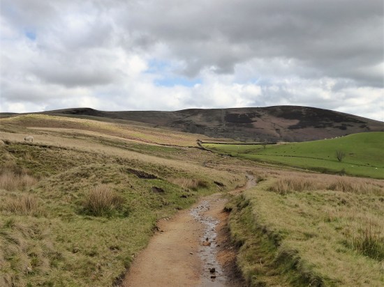
I drove through Outhgill which I visited yesterday and parked up at The Thrang for a walk I had picked off the net. It would take me up to the first Eden Benchmark, Water Cut – before visiting Hell Gill and its waterfalls, and then wandering back past valley farms.
Quite a broad track headed away from the valley floor, an old bridleway to Hawes at the head of Wensleydale. All the rivulets coming down from Mallerstang Edge were in full flow and my feet were wet after the first ford crossing. 

That dot on the horizon turned out to be the benchmark in its very prominent position – how come I have never spotted it before? After some steady walking and a few more fords it was reached at about 420m. 


Water Cut by Mary Bourne. 1996.
“Water Cut is located a few miles from the source of the river Eden, high up on the eastern side of the Mallerstang valley. Like a huge milestone, it stands alongside the ancient green road known as Lady Anne Clifford’s Way. The space carved between the two vertical pillars creates the shape of a meandering river in the sky and provides a ‘window’ onto the real river in the valley below. It also symbolises the power of the river Eden cutting through the rock on its journey through East Cumbria and our own human journeys through the rural landscape and through life. Made from Salterwath Limestone, taken from a quarry near Shap, it also resembles the gate posts and stiles in drystone walls, which are so characteristic of the area, whilst it’s outer curve makes reference to the viaduct arches on the nearby Settle-Carlisle railway.”
Mary Bourne is an accomplished stone carver, living in the North East Scotland. Her work explores forms of the landscape and her relationship with the natural environment.
I played about with various camera angles. The more I looked they resembled two salmon leaping, are there salmon in the Eden?


From up here one has good views north along Mallerstang Edge and across the valley to Wild Boar Fell. The limestone lower layers contrasting with the overlying gritstone.

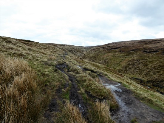
Not much farther I came to Hell Gill, I could hear it well before I reached the bridge over it. A deep rift in the limestone tearing down the hillside with thrashing waters in its depths. This was dramatic. I tried to get views down into the canyon but it was sensibly well fenced off. All was green mossy and ferny, I think there are fairies down there. 


The water tumbled on down the hillside and I followed. It came to a welcome rest at a ford. 


But what was that noise? A small steep detour and I could see the next and probably the best cataract. A video should have been taken. 


My boots were under water crossing the fast flowing ford. 
It must be all downhill from here but the next few miles tried my patience. I was basking in the beauty of Mallerstang and yet struggling to find the bridleway marked on the map on the ground. There was a lot more rough walking to come. It tended to keep above the top intake wall and hence involved tussocky grass and boggy areas. Few people use this way. 


There were a few more waterfalls to admire and the light on the other side of the valley was beautiful. No steam on the Settle to Carlisle today.


Eventually I made my way to the valley bottom and along by the Eden back to my car just as the sun was going down behind Wild Boar Fell.


I would highly recommend this walk, it packs a lot into those 6 miles without going onto the tops. I never saw another person.
Mallerstang-trail.pdf (edenriverstrust.org.uk)
***


A close up of the hedge laying motif showing how difficult they were to pick out.


|
|


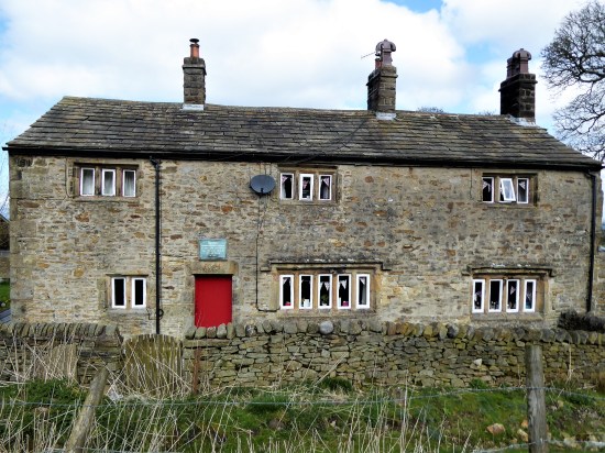
Faraday Cottage.


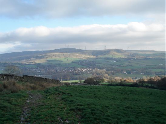
It must be 40 years since I walked ‘The Eden Way’, which as the name suggests follows the River Eden from its source in the fells above Mallerstang, through Kirkby Stephen and Appleby, past Carlisle to the Solway Firth. I remember I only took a bivy bag for lightness and ended up quite damp several mornings.
It’s an area a little out of comfortable reach from Lancashire and I have neglected it over the years. Some recent climbing nearby has brought it back to my attention and it so happens that one of the many books I have read in this month or so of poor weather was ‘The Stream Invites Us To Follow’ by Dick Capel. ( I seem to recollect John Bainbridge recommending it, that is one of the joys of Blogging, your readers, few though they may be, often come up with suggestions which you have overlooked. Thanks John )
Dick Capel came to Cumbria in 1982 working as a warden in the National Park as it was then. He changed areas in 1991 starting work for the East Cumbria Countryside Project, ECCP. This aimed to promote the conservation and enhancement of the natural environment of East Cumbria. During this time he became heavily involved with the Eden Valley and particularly in developing a series of sculpture trails reflecting the area. He writes evocatively of the area and his own trials and tribulations. In particular he highlights The Eden Benchmarks, The Poetry Path and a series of Goldsworthy Pinfolds that appeared under his watch.
*
The Eden Benchmarks.
The Benchmarks are a series of ten contemporary stone sculptures located at intervals along the length of the river Eden between its source above the Mallerstang valley and to the Solway Firth.
“Ten sculptor’s were chosen as part of the East Cumbrian Countryside Project, ECCP. The artists’ brief allowed creative freedom to produce site-specific sculpture, which harmonises with the landscape and captures the essence of each unique locality. The sculptors worked in residence for six weeks and this enabled them to formulate their ideas by familiarising themselves with the locations and talking with local people, including schools, who were encouraged to visit their workshops to see the sculptures taking shape”
“Collectively the sculptures give visual expression to our awareness of the river’s ecology and the need to look after it; individually they foster a profound sense of place, their capacity as seats accommodating an interactive focus for quiet reflection”.
*
The Poetry Path.
Encouraged by the success of Eden Benchmarks Capel’s next arts project was the Poetry Path by the Eden on the edge of Kirkby Stephen interpreting the hill farmer’s life and love for the Eden Valley.
“Twelve short poems, written by Meg Peacocke, have been carved by lettering artist Pip Hall on blocks of stone installed at intervals along a circuital route either side of the river Eden. Decorative motifs with each poem depict some of the activities associated with every month of the hill farmer’s year”
“The aim of the Poetry Path is to introduce a permanent and integrated interpretative experience into the landscape, which is assimilated as part of the heritage it promotes and conveys a powerful message about the farmer’s potential role in maintaining a sensitive but viable hill-farming regime in relation to the natural environment as a resource both for nature conservation as well as food production”.
I could not have written that.
*
Andy Goldsworthy’s Pinfold Cairns.
In the area there are six of these stone cones built into village pinfolds, which used to hold stray animals, Created by the sculptor Andy Goldsworthy (1996 – 2002) supposedly based on the prominent piles of stones called the Nine Standards above Kirkby Stephen. At one time Goldsworthy lived in the area.
*
The funding ran out in 2008 for the ECCP. But the art remains. Sculptures and poems reflecting the area’s heritage and beauty, and hopefully enhancing peoples enjoyment and understanding of the countryside and environment.
Dick’s book has acted as a catalyst for some exploration on my part. I find myself visiting friends up here so I have decided to stay on, I’ve booked into the Black Bull in Nateby for a few days. 
A related website provides all the information you need on all the installations. I have quoted above from that site.

*
“The stream invites us to follow…and certainly, there is no more fascinating pastime than to keep company with a river from its source to sea” W H Hudson, Afoot in England.
 More of a TripAdvisor review than a walk blog.
You may remember a walk I did a few weeks ago with Mike as a recce for of his group’s outing. Well Wednesday was the appointed day for the real thing, the monthly walk. The car park at the Hare and Hounds, Abbey Village, soon filled up, greetings made and boots were donned. The planned route followed paths through woods around the Roddlesworth Reservoirs. I came along as an extra, although I do know several of the other walkers – there were 24 altogether, oh and two dogs. That sounds an unruly number for the leader, Mike, to keep an eye on.
On the way over he was concerned that the group, who are prone to dawdle whilst they chat, wouldn’t complete the walk in time for the booked lunch; that areas of the way were excessively muddy; was it too steep in parts; would the small pub be up to providing a good meal for group. Getting lost was not an option. At least the weather was a perfect still blue sky day.
All went well on the walk. Everybody kept up more or less, the dogs were well-behaved. Most people avoided the muddy, but best scenic, section alongside the upper reservoir, I took a few that way and met up with rest a little farther on. Most of the spectacular backdrop to these woods and the significance of the reservoirs was lost on the throng – who needs insights when you are busy chatting? (My original post gives you all that and photos to boot, I didn’t bring my camera today)
Back at the pub the bar was inundated with drink orders from the couple of dozen arrivals. Credit to the barmaid for efficient and friendly service. Everyone seated, and the food arrived in fairly quick succession, a feat I admire from the chef. All seemed happy with their choices, there was a German slant to the menu as ‘mine host’ hails from there. Two hours passed, and then the crowd dispersed having thanked Mike for his excellent walk. I wonder if any will return to sample and appreciate the beauty of this area in a quieter slower mood.
My fish and chips were perfect.


Simon Armitage’s Stanza Stones – Mist.
We, Clare, JD and I, are well on schedule for our quest to visit the final Stanza Stone for today. After the Snow and Rain along comes the Mist.
The scenery changes on our onward Northern drive, deep wooded valleys crowded with solid stone terraced mill houses. Cragg Vale, Mytholmroyd (birthplace of Ted Hughes, Poet Laureate 1983 – 2008) Hebden Bridge, Pecket Well. We start dropping off the moor into Oxenhope when a steep narrow lane brings us back into the hills looking for somewhere to park under Nab Hill.

A muddy track leaves the lane, we check GPS that it is the correct one, a Stanza Stone waymark is soon noticed. Passing small quarries, no soaring climbing faces here, the rock is softer and splits into thin slabs possibly to be used as stone roof tiles common in Yorkshire at the time. We are on the lookout for a larger quarry on the right and then a stone cairn. Wind turbines look down on our wanderings. The problem is that there are several piles of stones on the edge of the moor, when is a pile of stones or a stone shelter a cairn? I dismiss the first stones and head farther towards an obvious larger cairn, ignoring smaller ones on the way. There is doubt in the team. The clue we have is to drop below the cairn to find slabs of rock. Nothing obvious here, how far down the slope should we go? We repeat the process under the other ‘cairns’. JD wanders off to pinpoint the OS map’s indication of the stone with his GPS, that doesn’t help. Clare scouts the lower ground, there are lots of slabby rocks about. I ponder that not being able to find the Mist Stone in the mist would be ironic, we are having difficulty on a perfect day. At last back at the first pile of stones we discover the correct slabs. 


The story goes that one slab was lifted in situ for Pip Hall to carve, it had a hairline crack down the centre and as the stone was moved it split, much to the consternation of the workmen. Undaunted Pip carved each one independently to later place them together, so that the lines hopefully read as one. (The picture of the split comes from their book) One has to give some thought to this lady out on the moor in all weathers carving away. These slabs are of a softer grit than the ones previously visited, Snow and Rain, and the lettering paler. Simon’s poem is equally evocative though, looking out over the valleys and moors where the Bronte Sisters once roamed for inspiration. Lichens are spreading out over the letterings giving them a more ancient look than their mere 12 years – come back in another 12 years. Someone’s ashes are scattered around and will slowly be blown across the moor or crushed underfoot.

The split slab back in 2011 before repositioning.


Mist.
Who does it mourn? What does it mean, such
nearness, gathering here on high ground
while your back was turned, drawing its
net curtains around?
Featureless silver screen, mist
is water in its ghost state, all inwardness,
holding its milky breath, veiling the pulsing machines
of great cities under your feet, walling you
into these moments, into this anti-garden
of gritstone and peat.
Given time the edge of
your being will seep into its fibreless fur;
You are lost, adrift in hung water
and blurred air, but you are here.
The three Stanza Stones we have visited so far have exceeded my expectations and I can’t wait to return with our team to the Ilkley Area, home of the Literature Festival where the idea was born, to discover the remaining three, Dew, Puddle and Beck. Wouldn’t it be great to find the fabled seventh, but I suspect that will only appear to an alert walker somewhere on the Stanza Stone Trail.
***
My navigation skills have improved for the drive home, – these are roads I know well up above Wycoller. We even have time to stop off to look at one of East Lancashire’s Panopticons, The Atom. Both a shelter and a viewing point over the valley and to Pendle Hill. I am sure from memory that when it was first installed there was a stainless steel atom in the centre of the ‘Molecule’ – no sign of it now.
(The other three are Colourfields in Blackburn, The Singing Ringing Tree above Burnley and The Halo above Rossendale.) 


The day couldn’t have gone better. Sunshine, excellent company and three poems found and enjoyed.
Simon Armitage’s Stanza Stones – Rain.
15 miles of scenic driving on open moorland roads and then through densely knit and gritty Pennine communities brought us to the White House Inn on the road out of Rochdale. We have just come from Marsden where up in Pule Hill quarry we found and admired our first Stanza Stone, Snow, a water themed poem by Simon Armitage skilfully inscribed by Pip Hall. This is one of six, or maybe even seven, scattered on the rugged Pennine Watershed between Marsden and Ilkley. There is a 45-mile walking trail between them all, but we have chosen to use the car and visit them individually. We have resisted the idea of visiting each stone according to the weather depicted. Let’s enjoy today’s sunshine.
The White House is an iconic moorland inn situated where the Pennine Way crosses from the peaty horrors of the Peak District peat to the pleasanter Yorkshire Dales. Many long distance walkers have been known to give in here. Most people today are either enjoying lunch in the pub or doing short walks from the road, as are we. 
The Pennine Way is followed alongside an aqueduct connecting several reservoirs. All level walking. I camped along here once with my young son on a Lancashire Borders Walk. Sensibly we had eaten well in the pub beforehand and only needed water for a brew. The brown peaty solution didn’t need a tea bag, today my tea was already brewed safely in my flask along with a picnic lunch.


A miniature arch took us over the water and into Cow’s Mouth Quarry. This is where I become boring once more as I try and trace routes climbed way in the past. They are mainly slabs, with often little protection available, needing a steady head. Nowadays with bouldering mats the picture has become blurred between a roped route and a high ball boulder problem. 

But I’m not here to climb today, I’m with Clare and JD looking for the second of Simon Armitage’s Stanza Poems – Rain. This one is easy to spot being at the base of a rock face right by the path. Pip had a lovely canvas to write on, but advice was first taken from climbers so that no footholds were destroyed, or new ones created. Pip’s carving seems more pronounced than on Snow back at Pule Hill, this rock, being more compact, maybe helping. The letters are imbued with gold. We read aloud the poem marvelling at Simon’s turn of phrase. 


Again here is the poem in case you can’t make it out in the pictures.
Rain.
Be glad of these freshwater tears,
Each pearled droplet some salty old sea-bullet
Air-lifted out of the waves, then laundered and sieved, recast as a soft bead and returned.
And no matter how much it strafes or sheets, it is no mean feat to catch one raindrop clean in the mouth,
To take one drop on the tongue, tasting cloud pollen, grain of the heavens, raw sky.
Let it teem, up here where the front of the mind distils the brunt of the world.
We find a sheltered spot for lunch. I forget to take a picture of the extensive views across the moors with distant reservoirs, wind farms and mill chimneys. I am on too much on a high from the poetry – tasting cloud pollen. We wander back with shared tales of moorland adventures.
Fellow us farther on our poetry quest.
Simon Armitage’s Stanza Stones – Snow.
Simon Armitage is steeped in Pennine Grit. Brought up in West Yorkshire and living in Marsden in particular, his works have been influenced by the rich heritage of the area. I have been reading a few of his books and poems recently and feel an affinity to his working class background. When you delve deeper you realise the profound and original intellect of the man and his ever widening focus. That’s why he is Poet Laureate.
My friend JD, who has featured many times in these posts, told me about some of Simon’s readings on the radio, such as his journey as a modern day troubadour down the Pennine Way, and more interestingly his series of poems carved and brought to life in the rocks of the high Pennines. The Stanza Poems, six poems on the theme of water in various forms: Snow, Rain, Dew, Puddle,Mist and Beck, a collaboration between himself, Pip Hall the stone carver, and local expert Tom Lonsdale, a landscape architect. Those looking hard enough might stumble across a seventh Stanza Stone, a secret stone left in an unnamed location within the Watershed area, waiting to be discovered and read. As far as I know nobody has.
I bought the book and was immediately fascinated. Stanza Stones a book by Simon Armitage, Pip Hall, and Tom Lonsdale. (bookshop.org)
What they have produced is truly magical and the insights of the protagonists brought to life in the book. I take my hat off to the literacy skill of Simon but equally so to the dedication and art of Pip the sculptress which will be borne out in our efforts to locate the stones.
A fairly tough trail, considering the moorland terrain, of 50 miles or so has been worked out between the carved stones from Marsden in the south to Ilkley farther north. Suffice to say JD and I never got around to walking it, mainly because I thought some of the 20-mile days across rough moorland with no bed at the end was too much for me to contemplate. I happily compromise and suggest a motorised raid to the individual stones. The idea catches fire and in a conversation with the ‘Slate Poem Lady of Longridge Fell’ (another story enacted in my lockdown posts) we have a willing and knowledgable accomplice. Welcome aboard Clare, one of her slate poems in her garden says it all.

Messenger. Mary Oliver.
Cometh the day cometh the hour. We are off to Marsden with a fair forecast. I’m afraid to say my navigational skills fell short of the sat nav lady whom I chose to ignore. We came at the first site in a round about way, but the moorland scenery and deserted roads were worth it. Mutterings from the driver and the other passenger who kept well clear of any navigational mistakes. 
An unpretentious lay-by below Pule Hill, west of Marsden, is our starting point. The steaming brick ventilation shafts of the Manchester to Huddersfield railway are obvious above us on the hillside. As well as the railway down there somewhere the narrow Huddersfield Canal goes through the Standedge Tunnel, the longest, highest and deepest canal tunnel in Great Britain. Their combined history is worth a read, it’s a lot more complicated than you think. Above all that are the ramparts of Pule Hill quarry and rocky edge on the skyline. Fortunately for us the original quarry incline is still intact giving an easy climb up into the workings. Memories of plodding up here with ropes and gear for a day’s climbing come flooding back, and I feel a quickening in my step. We are impressed with the amount of quality stone work just giving access to the quarries. What a substantial industry of men must have worked away on these slopes. 


I’m distracted by the quarry rock faces I have ascended in the past whilst the other two go off in search of the poems engraved in stone. 

Nature’s art.

At the far end of the quarry are two large blocks built into the wall and there is our first poem laid out in front of us, letters carved into the two stones bringing out the colours of the rock from those past quarrying days. We trace with our fingers across the rock surface. Already after 13 years the patina is changing, and green lichens are crossing the letters, what will another decade bring. There is already some slight damage caused by man. 


Here is the poem transcribed as it is difficult, but not impossible if enlarged, to read in the photos. The stanzas cross between the two stones.
Snow.
The sky has delivered its blank missive. The moor in coma.
Snow, like water asleep, a coded muteness to baffle all noise, to stall movement, still time.
What can it mean that colourless water can dream such depth of white?
We should make the most of the light.
Stars snag on its crystal points. The odd, unnatural pheasant struts and slides.
Snow, snow, snow is how the snow speaks, is how its clean page reads.
Then it wakes, and thaws, and weeps. S A.
Before we leave, we discover a beautifully constructed curving wall seat inscribed with ‘Ilkley 45 1/4 miles’ which is the distance to the last stone via the trail, thankfully we have the car to take us onwards.

We skip happily down that incline, pleased to find the first stone and captivated by the scenery and the poem it now holds. Let it snow.
***

Well there were JD and me, the three scientists doing a peat survey for some research organisation, the Three Stone Men who have been there for who knows how long, and a few others stone ones scattered around. The peat survey was interesting as we are just waking up to the importance of peat as an important carbon storage resort. We were happy to sit in the shelter of the Three Men as there was a distinctly cold breeze coming from the Northwest. A good opportunity to take a break and eat our sandwiches.
Our journey up the motorway had not been straight forward as I missed the turn-off to Caton and the Lune Valley. Another junction farther north and JD’s phone chose an alternative route over towards Kirkby Lonsdale, although eventually on the A65 we ignored the lady navigator and followed the sign up to the little hamlet of Ireby. I shall not reveal where we parked, but there should be space by the telephone (book) box. Surely we are in Yorkshire by now, but no the Lancastrians have pushed a finger into Cumbria and Yorkshire. We are in fact out to climb the highest (allegedly) hill in the Red Rose county, walk number 16 in Mark Sutcliffe’s Cicerone guidebook.
Up to now we have been walking on a distinct lane out of Ireby and then the tarmac road heading up the fell from Leck. All easy going, gaining height almost effortlessly, at least we could keep up a good conversation without getting out of puff. JD is super fit at the moment having recently completed a pilgrim route to Santiago, a Scottish trip and The Dales Way. I was hoping that his all-inclusive hotel stay in Menorca with his wife might have slowed him down. We are in limestone territory. 


This road leads to a remote sheep farm. I used to park up along here for exploring the nearby Leck Fell potholes. Short Drop Cave was always a favourite, lowering yourself in with your feet dangling in fresh air in the darkness, dare you let go of the rock? Of course, you did and only dropped a few inches! You could explore the channel for some distance and then worry about getting out again. But today we were heading up to those stone men visible on the hillside above. Conversation dwindles on the steepest scrambling bit, look at the contours, and we are all too ready for that rest at the Three Men. 

The Three Men.

The Three Ladies.

Lunch over we chat to the peat surveyors before strolling the last section to the lonely trig point on Gragareth, 627 m, the highest in Lancashire. Now this is where some debate comes in, farther north across the barren moor is Green Hill, still in Lancashire, and marked on the OS map as 628 m. We don’t fancy the two-mile boggy trudge up there. But help is at hand – in 2014 the Database of British and Irish Hills suggested “Gragareth replaces Green Hill as Lancashire county top”. Gragareth having a height of 628 metres, 100 metres east of the trig point, while Green Hill is 627.5 metres. Who knows? 
Anyhow, we slink off along the wall southwards. But I have forgotten to tell you about the views from that highest point. Morecambe Bay, Lakeland hills, nearby Barbon fells, all those rounded hills up to Dentdale, Whernside and of course stately Ingleborough, distant Pendle and the Bowland Fells, quite a collection.

Northwards.

Whernside.

Ingleborough.
On down along the wall and then a vague path down to the ‘Turbary Road’ above Kingsdale, a track used by peat cutters – yes we have been destroying the land long before climate change was thought of. This area is full of caves, potholes and dry riverbeds, but the way missed most of them out. On reflection a few small diversions to peer into these limestone features would have added interest. 


Marble Steps Pot.

Twistleton Scar End.

Turbary Road.
Once on the lane we made good progress stopping only at a bench for a drink, out of the vegetation crept a giant dung beetle. 
Masongill looked delightful.
Freshly cut green fields, and we were soon crossing the ancient clapper bridge into Ireby.


It was good to be back in Limestone Country, as you can see the weather improved as the day went on. Eight and a half miles with 1700ft of ascent – I’m still thinking imperial.
***


Walk 37. Weets Hill from Barnoldswick.
Barlick, until local government reorganisation in 1974, was in the West Riding of Yorkshire. It then found itself in Lancashire, the locals were not happy and many still see themselves as Yorkshire folk. Back in the day, until 1992, you had to be born in Yorkshire to play cricket for the county and I seem to remember special dispensations being given to players from Gisburn/Barnoldswick area when they were in Lancashire. Or was that just a rumour at the time. I do remember well however White Rose flags flying defiantly in Gisburn as you drove through.
None of this has any relevance to today’s walk except to point out we are in the far east of the county where Lancashire mills give way to Yorkshire dales. A 10-mile day of easy navigation, gentle gradients, canal towpaths, a Trig point and lots of fields. Stick with it – there is plenty of interest.
I approached the recommended Greenber Field car park down the narrowest of lanes, I was almost giving up when it suddenly appeared hidden in the trees. On my return I took a wider road, the B6252, back into Barnoldswick and I would recommend that as your approach. Unfortunately the café on site was closed due to staffing shortages, a common problem of hospitality in these strange times. That’s the second day in a row I have been deprived of my coffee. Still the day was promising with warm sunshine and blue skies.
I set off with enthusiasm along the canal towpath on the edge of town. Easy strolling with lots of friendly and well-behaved dog walkers, pram pushers and cyclists. I passed three of the prominent manufacturers in town – Rolls-Royce, Silent Night beds and Esse stoves. All but one of the many cotton mills have gone. The canal was busy with boaters. On my longer canal walks I often try to pick out the most humorous, or more likely corniest, boat name of the day, Mr. Grumpy won today. All making for an enjoyable start to my day’s walk.


In fact the morning was disappearing fast – made more so by an extended chat with an enthusiastic walker. We got onto the subject of the Lake District which he seems to have just discovered. Out came his phone with pictures of Coniston, Helvellyn and Scafell etc, many in selfie mode. I had to make my excuses to get under way again.
Once I had left the canal I saw virtually no one else for the rest of the day.
My way up onto White Moor was mainly on well surfaced bridleways, that PBW again. As height was gained the views opened up, with my recent ascents of Bouldsworth and Black Hambleton prominent to the south along with the rest of the Pennine Chain, and there was little Blacko Tower. Perhaps I was distracted, but I took to the moors sooner than I should have, up a well trodden track (SD 869 441). On past a plantation obvious on the map, that’s when I realised my mistake, but the track alongside a wall was good, so I just kept going until I was within a stone’s throw of the summit. Birds eye views of Barnoldswick appeared way down below.


What did I say about easy navigation? As it happened this was possibly better than the longer way round and up the tarmacked lane to Weets House, it was easy to navigate once I knew I was lost – if you follow my logic.
The summit was adorned with a shiny white Trig Pillar and even better as I was ready for lunch a memorial bench. And what a panorama – the nearby bulk of Pendle, Longridge Fell, the Bowland Hills , Ingleborough and Pen-Y-Ghent and lots more. The Ribble Valley stretching out in front of the hills completed the scene. 


It was only after some time sat there enjoying the view that I noticed beneath my feet little plaques set into the soil, each one a memorial to a departed family member whose ashes were no doubt scattered up here. I like the idea of being scattered from one’s favourite hill, but I thought the plaques possibly out of place. No offence to any family concerned who had the wishes of their departed granted.


Time to head down, and I followed the track I should have come up to Weets House, an isolated property as you could wish for. Back on the PBW I headed north wondering who had travelled this way in the past centuries attending to their trades. Miners, pack horses, farmers, soldiers? The map depicts ‘ancient earth works’ from early times and there is a Roman Road crossing my track at one point. 


A quiet road, Brogden Lane, winds down the hillside past upland sheep farms and comes to a right angle corner at The C18th Manor House, what you see from the lane is actually the back of the house. A ford then leads to Brogden Hall. That was my way and I circled around what is a large equestrian centre with only a glimpse of the hall itself. Out into the fields I crossed a motor cross circuit – the penny dropped I have been here before. It was when I was walking the West Craven Way in 2015. 


The pastures were full of deep grass which surprisingly makes walking through it tiresome. It’s that time of the year when the dairy herds are let out for some proper food. Passed a reservoir, and I was into a field with one of the largest herds of cattle I’ve encountered. They can be frisky at this time of year and being cautious I took to a path on the other side of the wall. After my minor trespass I was back on route up a slope now with grazing sheep and their lambs. I couldn’t resist a spring lamb photo, or two. Can’t you just taste that luscious grass? 


I worked my way through the gardens of some nouveau riche house, their garden furniture was more stylish than my lounge. I’m not jealous, but it set me wondering if they were entertaining would you be offered a drink en passant. 

This was on the edge of the little hamlet of Bracewell where there had been a former hall. The church, St Michael’s, dates back to the C12th but most of the present fabric dates from the C16th, though there is a Norman style arched doorway and apparently inside a Norman font. (it was locked today) For some reason I ignored adjacent Hopwood House and Farm, both grade II listed. But my attention was drawn to the ‘Old Post Office’ with its inscribed plaque, but why on earth did someone build a porch whose tiles obscure that plaque. 


I have a gripe with Mark for the next part of his route down the busy and twisty B6251 road. This is dangerous considering the speed of traffic along it. Driving back along that stretch on my return I was behind an articulated lorry doing well over the permitted 40mph, no chance of that stopping quickly. Looking at the map there is a footpath leaving Bracewell to the abandoned village of Stock where there may be earthworks to see. A public footpath from there crossing Stock Beck would bring one back onto the bridleway route. I wish I had taken that way, which as well as avoiding the dangerous road looks to be of interest in itself. I would recommend you do.
I didn’t, and I had to brave the oncoming traffic for half a mile until I could escape onto a peaceful bridleway. If you look closely at the contours of the countryside here you will see lots of small hillocks. These are drumlins, glacial deposits of boulder clay on the surface limestone. Today with the abundant Spring greenery they took on a magical landscape over which I expected troops of elves to come skipping along. It was however a good place to watch lapwings in their rapid flight. 

The walk ended through Greenber Field Farm. All very neat and tidy but far removed from the farming as I knew it. Massive sheds, computerised cows and not a farmer in sight’. The C18th house itself is Grade II listed.


Well not quite the end as I spent some time watching canal barges come through the lock gates, the summit of the Leeds -Liverpool Canal. 


***


I’ve been impressed so far with the walks from Mark Sutcliffe’s Cicerone guide to Walking in Lancashire. It’s a big county covering all types of terrain from the Coast to the Pennines, and he has chosen well. I must have walked most of his routes many times in the past, but he keeps throwing up little gems of variations new to me. Today was no exception. Nobody in their right mind would climb Pendle up those steps from the overrun village of Barley, I did in October 2020 as the lockdown restrictions for Covid were being relaxed. Never seen so much congestion on the roads or hill, but I was on a mission that day to find Fox’s Well. Mark takes us the quiet but long way up from the little village of Pendleton, a hamlet (tun) close to Pendle.
Pendle Hill dominates the landscape as you drive along the busy A69 though the Ribble Valley. It was along here I came today before branching off into the peace and quiet of Pendleton. I paid my dues and parked in the village hall’s car park as suggested in the guide, Walk 34 – ‘a challenging walk‘. I have been slowly increasing the mileage that my knee injury will cope with, it is nearly a year since the cycling accident that tore the medial ligament. Time is a slow but reliable healer, today’s rough 10 miles would be a test.
The sun is out as I walk past the Swan with Two Necks, I have visions of a pint outside on the return. Pendleton is unusual in that it has a stream running down its main street making it a favourite Ribble Valley venue. The pub regularly wins awards for its beer and food. Higher up the village the Fiddle Stone, once a clapper bridge across the stream now curiously spanning a patch of grass


Leaving aside thoughts of beer, I soon take a lane into fields which rise up to Wymondhouses, a Pennine farm once used as a chapel. The plaque above the door states that the first Congregational Church in north-east Lancashire was founded here in 1667, a Mr Thomas Jolly being the nonconformist preacher. 


Rougher pastures and a sunken way led me onwards higher to come out onto the road at the Nick of Pendle, a low pass through these hills between the Ribble Valley and Sabden. A popular stopping off point for motorists seeking a picnic and a view. There were quite a few cars parked up this morning, the first people I had come across.

Back to Longridge Fell and Bowland.


Sabden down in the valley.
I was quickly back to peace and quiet on an obvious bridleway heading for Churn Clough and the Deerstones.

Bridleway with Deerstones on the horizon.
Below is the almost circular Churn Clough Reservoir, now used for fishing. Our path crosses the clough and then climbs steeply up its right bank heading for the Deerstones marked on the OS map. It is quite a pull-up. The day has changed, the sun has disappeared, and dark clouds fill the sky. The Deerstones look menacing in this light. At the back of my mind there is something of interest in the quarried stones, but I don’t divert without good reason. (I later read of the Devil’s Footprint. This feature was natural and caused by nodules of iron rich stone eroding out the harder gritstone bedrock. The legend is that the footprint was left by the Devil as he gathered stones in his apron to hurl at a nearby church. He then clumsily dropped them at nearby Apronfull Hill. I suspect that without prior knowledge the footprint would have been difficult to find. 


The Deerstones.
The path comes out onto the open moor at a gate. Paths go in all directions. I just head north on the vaguest of paths to join the main route coming up from the Nick. Pendle is a big hill and I feel minute in this landscape, it wouldn’t take much to get lost in its vastness on these SW slopes. All is sky and skylarks. You can’t capture this with a photograph, especially now that it is so dull.

Could be anywhere.
The path becomes more defined on the lip of the prominent Ogden Clough, a highlight of the day so far. 


I have distant memories of ploughing directly up that clough in a hard winter when all other tracks were obliterated. Today the going is good and as one approaches the summit the path has been ‘flagged’ to prevent erosion. There are still very few people using this way, but I fall into conversation with Max and his dog. He is full of tales of Lakeland walking, recently having completed the 214 Wainwright’s. He admits to being a little nervous on some of the Lakeland scrambles, I encourage him to take on Sharp Edge on Blencathra and maybe even Jack’s Rake on Pavey, I am not sure if he is convinced.

Wes, dog and flags.
By now we have reached the summit Trig point, at 557 m,and realise the place is thronged with people from the Barley side, what a contrast to our way up. Nonetheless, it is a good viewpoint over Pendleside and a sit down for a snack, but not for long as under the cloud it is decidedly chilly.


 A new path has been fashioned from the top of the Barley steps to the trig point. I must admit it blends as well as possible into the plateau and must save a lot of erosion. There is also a new stone shelter built into the nearby wall. Once through the wall as if by magic everybody disappears, and I have the whole of Pendle Moor to myself. There is no wind today, so it is almost perfect silence apart from all those soaring skylarks.

Empty spaces – skylark country.
Past the stone shelter and on to Scout’s Cairn, the path is very boggy all the way. The Yorkshire Peaks are a bit hazy, but I’m focused on Kemple End, Longridge Fell and Parlick, Fairsnape Fell framing Beacon Fell straight ahead. As I said photography is difficult in this light. 
The moor goes on forever. But is that sunshine returning? And now for that little bit extra. After a memorial cairn I drop steeply down into the extensive Ashendean Clough, a deep incision in Pendle’s SW slopes. This could be Scotland.

Memorial to two Clayton-le-moors Harriers members.

Down steeply to Ashendean Clough. Can you spot the Nick on the horizon?

The guide says to cross the stream, but that is not so easy today without getting my feet wet or even worse. A perfect little valley full of bright yellow gorse. A footbridge by a barn and I’m into rough pasture aiming for the next barn which I cannot see, but we get there in the end and come out onto the lane by Mearley Hall. That has been quite some hill day.


Howcroft Barn.


I arrive back in Pendleton and treat myself to that beer, sat outside in the late sunshine. Perfect. Reflecting on what has been a connoisseurs walk, mostly away from the popular Pendle routes. That has been quite some hill day.
***

 I couldn’t resist a decent hill day as the weather remained fine. All change next week. ‘Head east old man’ was my mantra as I sped along the M65. Everyone else was going west to Blackpool or the Lakes. Boulsworth Hill my objective. So far so good, but the last chapter of Mark Sutcliffe’s Lancashire Cicerone guide would have had me parking above Wycoller. If there ever was a honeypot then Wycoller deserves that title. A secluded village of agricultural and hand loom workers in the C16th to C18th. Along came power looms in the C19th in nearby Lancashire towns and the population moved out. By 1896 the majority of people had moved away from the village, and it was virtually deserted. But a renaissance occurred in the mid C20th, the area was incorporated into a Country Park and people started moving back into the village renovating the properties. I well remember Longridge acquaintances of mine telling me of their plans for one of the houses in the 70s. I suspect you would have needed a bottomless purse to go ahead. For more information look at Wycoller (abandonedcommunities.co.uk)
The village is a now a conservation area and is closed to outside traffic. The car park on Trawden Road is the one suggested for this walk. Today, Easter Sunday I suspect it would be probably full by the time I arrived and you have to pay. So I decided to park up in Trawden village on the line of the walk. This worked well, makes the walk more balanced and avoids backtracking at the end. I will give details at the end of the post.
Out of the car I was soon winding my way up a lane into the hills, slightly more directly than Mark’s route. Footpaths then led past isolated farms. I came across two unusual stone stiles with a circular centre and exits into three separate fields, difficult to describe and difficult to photo, but I have never seen anything like them before. On down an ancient track into Wycoller.

Early fields with the amorphous Boulsworth on the horizon.

Early crows’ nests in the bare trees. A walled enclosure like a pinfold.


 A good start to the day, although by now it was after noon. The expected crowds were milling around in the hamlet. Crossing and recrossing the series of bridges over the stream. For the record …


The information centre/café appeared closed, but some enterprising folk were running a mobile coffee shop, it was too early for me. This walk gives you the opportunity to explore Wycoller if you haven’t been before. I had a look around the remains of the hall and was reminded of the time when I slept in the fireplace Inglenook whilst on a two-day trip around the Pendle Way. At the time I was unaware of the phantom horse ghost story associated with the hall. If I had known I may have slept elsewhere. 

You have had enough historical homework on the area so far, and it is time to move on. There are ways either side of the stream, but the important junction is well signed leaving the Pendle Way and the Bronte Way to take a concessionary path alonside Turnhole Clough. (the Bronte connection being that Wycoller Hall may have been the inspiration for Ferndean Manor Jane Eyre’s residence with Rochester after the fire at Thornfield. The Bronte Way is a worthwhile short/long distance way)
Families were enjoying the country park with Easter picnics whilst high above the sci-fi Atom, one of Lancashire’s panopticons, looked down on us. 

I don’t think I have been in Turnhole Clough before and I enjoy strolling through the trees above the lively beck. This sort of concessionary path should be more commonplace, I can think of several areas crying out for access. It just needs the local authority and landowners to come to some agreement, maybe pushed by interested rambling groups. 


Anyhow, eventually the Clough brings me out onto open moorland. Above on the skyline is a row of rounded gritstone boulders which look interesting. I have a hill to climb today, so I’m not keen to add extra height wandering off route to them. There is a path up towards them but when I later search on the UK database there is no mention of them being climbed upon. I now regret coming so close without visiting, all I have are some telephoto pictures. What are they 10, 20 or even 30ft high, it is difficult to tell? Another day. 


The book states you come out at the bailey bridge and cross it, but the concessionary path actually brings you back onto the Pennine Bridleway/Bronte Way above the bridge. Now we head across open moorland on this ancient flagged mule track.

Perfect wild camp site in the upper Turnhole Clough.

Which way?


Up and down until the barn where a signed path heads upwards to Boulsworth. This is a relatively new way so tends to just head upwards, none of the characteristics of worn winding historic routes. All is well until a fence is crossed and then the brutal 1000ft climb rears up steeply in front of you. I’m too old for this game but plod on at a slow pace being glad I stopped for an energising bite to eat back in the clough. Sometime later I breasted the ridge at some prominent gritstone boulders, Little Chair stones. Onwards past more boulders, The Weather Stones, I give them names in my imagination or am I hallucinating? Any suggestions?

Start of the ascent.

The steepening.

Forever onwards to the Little Chairs.


Up at last to the trig point at 518 m, Lad Law. There was nobody else here. Panoramic views over Lancashire and Yorkshire but now a little hazy. Am I actually in Yorkshire, well not quite but a stone’s throw away paths head deep into Bronte Country to the east. It all looks very bleak.

Lad Law trig 518 m.

A hazy distant Pendle over the Coldwell Reservoirs.
Turning back into Lancashire I head off downhill past the prominent Abbot Stone, too steep to contemplate bouldering.

The Abbot.


Boggy ground has me back on the Bridleway where after a few yards a stile takes me into fields and alongside Gilford Clough. Farther over to the right is Lumb Spout waterfall, a hidden gem. Maybe Mark missed a trick there, worth a diversion if you know where it is.

Gilford Clough
I’m content to walk down the lane past an assortment of farmhouses, cottages, hen houses, barking dogs and allotments back into Trawden. A village where the residents run the library, pub, shop and community centre.

Trawden FC?

Free cooperative seeds.

Is they Islay?

Yes it is Spring but not summer.
***
My parking was on Lanehouse Lane just past the bowling green area alongside an old cotton mill where there is adequate room close to where the route enters and exits the lane. SD916380
I was glad of this choice for it meant after a long tiring descent I was saved the climb back over to Wycoller completed earlier. The map makes sense.


I’m being unkind there, the darker side of the Pennines is actually in the White Rose county. But it is often gloomy as you drive down through these eastern Lancashire valleys with the prominent Peel Tower watching over you.
Walk 28, Holcombe Moor from Ramsbottom promised “A non-too-demanding walk from the endearingly quirky of Ramsbottom up onto the moors and back in time for coffee and cake – or a pint – in one of many inviting bars and cafés” That turned out to be a little short on the detail, both good and bad, but we are out for adventure and discovery after all.
Ramsbottom, forget the corny jokes, is, or was a solid Lancashire Mill town. Wikipedia as usual has more than enough information. It is now an apparently thriving, on the evidence of all the people there today, shopping destination. Its strength is the number of independent businesses both basic and frivolous. Parking was not easy on a busy Saturday. The station, one of the main attractions, with sometimes steam hauled trains up the valley on the East Lancs Railway was just around the corner. Only diesels today but come later and there will be Santa Specials.


Relics of the past.
I’ll gloss over the first stretch through a modern industrial landscape. But all of a sudden one is out into open fields with the River Irwell alongside. I’d been here before on the Irwell Sculpture Trail which at the time seemed very short of sculptures. Today I was noticing things new like the ‘stone hedge’ bordering a field, the nod to industrial heritage on the site of Cross End Mill, (a C19th dye, bleach and subsequent textile print works) the little allotments and a modern day communal food bank.


The path deposited me in the isolated hamlet of Strongstry, a couple of back to back streets which must have provided housing for mill workers in the past. There seemed to be a sense of community with book banks and bird feeding stations. A nice place to live.


Now for the interesting and unexpected bit, underplayed in the book. A scramble up alongside a lively stream in a hidden, rocky, tree lined gorge. Pure delight for 3/4 of a mile and 500 feet of climbing. Well done the National Trust who care for this land.


Out the top and across the road the character of the walk changes as open moorland is reached with increasing views over all those industrial valleys. The arrival at the top was greeted with a plethora of signs warning of the dangers of the MOD firing range, with more regulations than you could throw a bomb at. There were no red flags or explosions today, so I could happily trip along the ridge of Holcombe Moor.


The main point of interest was a stone monument erected in 1902 on the substantial base of an ancient Pilgrim Cross. The inscriptions told of the way to Whalley Abbey in the C12th.


From there I could have made a beeline to the distant Peel Tower over Harcles Hill, but the going looked boggy, and besides, I was following Mark’s footsteps. His way was no less boggy but had views down into the steep sided valley of Red Brook south of Bull Hill. I’m not certain I took the right track; there were so many, but eventually, I homed in on Peel Tower after an arduous half hour or so, again underplayed in the guide. It was a lot taller than I had remembered, 128ft in fact, and today, as always, the destination of many family groups coming up the short way from Holcombe. Built in 1851 with a public subscription to mark gratitude to locally born Sir Robert Peel for repealing the complicated Corn Laws, which were causing starvation in the agricultural workers. Political intrigue was as complicated then as it is today. I think of him more for his reform of the criminal justice system and the establishment of Police Constables, ‘peelers’.

A murky tower in the distance.

Arduous conditions – welcome to winter walking.

Bull Hill – I’ve never knowingly visited.

Tried an arty shot with the ‘towers’ of Manchester in the background. It didn’t come off.

Look at the size of the figures.
I found a good stone to sit on overlooking the valley and opened my lunch box containing my lovingly handcrafted egg and tomato salad sandwich. Placing it on the stone behind me whilst I poured some hot tea. Reaching for the anticipated sandwich, it had disappeared. I had to look twice, but it just wasn’t there. The culprit was a silent poodle who must have crept up behind me; there he was, finishing off my lunch higher up the hill. I suspect his owner was hiding out of shame.

There’s a dog up there… I’m on my way down.
Rested but not fed I started to make my way down steep tracks, past a Millennium Bench, and lanes through Holcombe. A mixture of old stone cottages and extravagant new properties, the former predominating the lower I went. My intention was to stop off for a pint in the Shoulder of Mutton pub and phone the plastic bag man living nearby for him to join me in what was once one of our haunts after climbing. But alas, the place was boarded up, ‘landlord needed’. It is not a good time for pubs. So down steeply, and I mean steeply, into Ramsbottom.


A Lowry’esque church – Holcombe.
 The streets were still busy. I was disappointed to see also that the Grant Arms in the centre had closed; I stayed there on the Irwell Sculpture Trail; it was pretty grotty at the time I must admit. It is now a financial investment office. You can see why traditional pubs suffer as quite a few small bars were scattered around, offering a good range of beers often home-brewed, cocktails and a bright environment. They were all full of happy people.


Maybe here lies the answer…

…more likely here in a modern bar.
I was pleased to see that the welcoming Chocolate Café across the way was still in business; it was always a haven on shopping trips. All things chocolate.
Anyhow, a change of plan, and we were soon sat in The Garsdale on the edge of Bury enjoying a beer and chewing the fat, as they say in these parts.
A superb varied walk full of interest but a little more demanding than Mark suggests, or am I getting old? Surely not. Thanks for sticking with me.


Glorious May.
Walk no 36 from Mark Sutcliffe’s guide combines the hills of Billinge with the River Darwen.
The River Darwen winds its way through the urban environments of Darwen and Blackburn and then has a glorious run in the countryside to eventually empty into the Ribble. I first met it today as I followed Mark’s route from Pleasington Station into Witton Country Park. Here it flows quietly through the meadows and playing fields. Walking upstream I met lots of families, dog walkers and picnickers in the afternoon sunshine. The park s very popular and well-used by the multinational people of Blackburn.

Billinge Hill above Witton Park.

Butler’s Bridge on the River Darwen.
Soon after leaving the river I was climbing steadily for what seemed ages but was only a mile or so. There are paths everywhere in Billinge Woods, there is even a tunnel, and I do find them confusing, so it was with some surprise that I found myself at the summit without any problem. The instructions in the guide were spot on. The OS map shows this as a viewpoint, but that was long ago before the trees took over. Maybe a bit of forest management by the council is needed. The plaque commemorating a court up here in 1429 is looking worse for wear also.


I headed west to find my way out of the woods and onto the ridge of the Yellow Hills (named after the Gorse that flowers here most of the year) pausing at the toposcope dedicated to Alfred Wainwright who needs no introduction. There were views over the nearby towns, but it was too hazy to see his beloved Lakeland. There are several links to walks to the memorial For more details.


Paths, now following The Witton Weavers Way, led down through bluebell woods, lush meadows, inquisitive cattle, newly cut fields, into the wooded gorge to meet the River Darwen once again. This I followed on familiar ways through the old mills at Hoghton Bottoms, under the railway arch and past the weir into meadows alongside the river. The last time I was along here the paths were almost impassable with mud and water, today the ground was bone dry.


Ford through the Darwen, oh there is a footbridge.


I didn’t enjoy the stretch alongside the busy A road and was glad when I turned off on the lane back to Pleasington. A seat in the garden of the parish churcof Feniscowles, Immanuel, was ideal for a break and snack. The River Darwen was crossed for the last time at Walk Mill, and I was back at the station where the local bowls club was in full swing as was the pub opposite.

Remains of Old Feniscowles Hall down by the Darwen.

Immanuel Church Feniscowles.

One for the archives.


I had seen a sign for Pleasington Priory and realising it was just a little farther up the lane went to investigate this Grade I listed Catholic Church. Trees in the grounds prevented a good view of the exterior with its tall front elevation. Above the arched entrance doorway was a prominent rose window. Gargoyles and statues seemed to be everywhere.


A well thought out and varied walk, apart from the short unavoidable A6061 stretch. The day was perfect with the countryside at its late spring best, making me feel truly alive. The modest 7 miles took me nearly four hours against the three suggested in the guide, I wasn’t rushing as I tried to protect my knee ligament and there was a profusion of colourful flowers to photograph.


*****


In less than 20 minutes it is reported that 241 died and 392 lay wounded from the 700-strong Accrington Pals battalion of the East Lancashire Regiment on the first day of the Battle of the Somme, July1st1916. Lord Kitchener was responsible for devising ‘Pals’ battalions from the same neighbourhood so that recruits could fight alongside their friends. Unfortunately, when there was a massacre, losses were concentrated on single towns. Accrington was one such town. More of that later – but first I have a hill to climb, Great Hameldon, another chapter from Mark Sutcliffe’s Cicerone book.
I have parked up just below Peel Park and find my way up woodland paths to the view point and Peel Monument. The crowded streets of Accrington slowly retreat down below. There is also an unexpected trig point up here on the Northern rim. I then follow the edge of the hill around above the A56 speeding though the gap below, a road familiar to me with the quarried walls either side. There is a way under the carriageway and I head up to, but circle around and above, the farm onto Moleside Moor. Behind a wall are a couple of ‘slate poems’ but I think from a different pen than the ones around Longridge. Rough ground and then bog bring me to the base of Great Hameldon for that steep ascent to the trig point. I’m not sure whether I have been here before. All is space with extensive views, unfortunately hazy despite the bright sunshine and strong wind. Pendle always dominates, and away to the East is the weather station on Hameldon Hill. There is nobody else up here except the skylarks, singing above me.
From the trig, a vague path takes me south to a wall next to an ancient well. //thejournalofantiquities.com/2015/03/01/mary-hoyle-well-hyndburn-moor-lancashire/
Strangely, a reservoir to the right has been decommissioned. Then I’m on a sunken bridleway passing through a quarried landscape. I have to get across the busy A56 before following a golf course to find myself in a housing estate. The guidebook sees me through this maze, out through Lounds Wood and into Haworth Park below the House which serves as an art gallery.


This brings me to the second part of my post. A friend visited the Haworth Gallery recently and commented on their unique collection of Tiffany Glass, all unknown to me. Time for a visit, this walk happens to come this way – how convenient.
The Haworths were successful mill owners and William had Hollins Hill, now the Haworth, built in a Tudor style, by Walter Brierley in 1909. He lived there with his sister, but died in 1913, followed by his sister in 1920. The house and its collection of paintings and antiquities were bequeathed to the people of Accrington. It has remained a gallery ever since, with preservation and restorations over the years.
The link to Tiffany is through a Joseph Briggs, born in Accrington in 1873 and until he was 18 worked as an engraver in his father’s Calico printworks. He then emigrated to America and in due course was employed at the Louis Comfort Tiffany glass works, famous for innovative art nouveau design. Briggs did well at Tiffany’s and when Tiffany retired in 1919 Joseph was in charge of Tiffany Studios producing windows, mosaics and lamps. Fashions changed, and the company faltered in 1932. Tiffany died in 1933 leaving Briggs to dispose of unwanted stock, throwing much of it away. But then he started sending some of the finest pieces over to Accrington.
Joseph Briggs died in New York on 28 March 1937, aged 64. Originally the collection was displayed in Oak Hill Museum but later sent to the Haworth Gallery only to be packed away during the Second World War. It was only in 1976 that this world-famous collection of Tiffany Glass went on show again.
The house itself is imposing, with views across the valley to Great Hameldon and my morning’s route. The grounds are extensive, and apparently the rose garden has to be seen in season. But today I am more interested with the interior; wood panelled rooms, feature fireplaces, a curving staircase. A welcome from the friendly staff, and I’m off to their in-house café for a coffee. This seems a popular meeting place for lunch, the plates all looked very appetising.
Revived, I commence my tour of the Tiffany Collection. The history and techniques were fully documented, and the variety and styles of glass was amazing. Only later did I notice that photography was not allowed. In any case the shades, different lustres and forms of the glass have to be appreciated directly. The collection filled rooms on the ground floor and spread up to the next floor. The elegance of the rooms fitted well with Tiffany’s artistry.
Also up here was an exhibition of watercolours in the corridor and oils in one of the adjacent rooms. These were the work of a Paddy Campbell and depicted scenes from the local moorlands. Some robust, larger oils were very impressive, interpreting the wildness and lighting perfectly. He has definitely been out there capturing the magic. This temporary exhibition had just opened and the artist himself was wandering around, all too pleased to expand on his canvases.


Before leaving, I visited in the grounds an Accrington Pals Memorial, which brings me back to my introduction to this post. This is a replica of one in Serre (built with Accrington Bricks), on the site of the battle of the Somme.
Farther down into town, I came into Oak Hill Park, where on the highest point was a war memorial erected in 1922. Tablets name 865 fallen from World War I and additionally 170 from World War II. One further name has been added, for Northern Ireland, and two from the Falklands Campaign.
Soon I was in the centre of Accrington and its grand stone Victorian buildings from the cotton era, where next to the church was a further smaller memorial (2002) to the Accrington Pals and other Lancashire regiments losses.


I had a slow trudge back up through the streets to find my car.
*****


I’ve not been far from base recently. There is a cousin, ‘the pieman’, living in Skipton whom I’ve not met up with for two years. Admittedly, he has phoned me on several occasions with a suggestion for a walk, but I have always declined with the excuse of injury. This can’t go on. It turns out he is suffering also, so when I suggest a short walk, on his home territory, the die is cast.
Yorkshire Limestone has been a favourite climbing venue for me over the years. Malham, Gordale, Attermire, Twistleton, Crumack Dale, Oxenber – the list goes on. The last time I visited the imposing Pot Scar the polish on the holds was unnerving, so in recent years, we retreated to the safer bolted climbs of Giggleswick. Why not revisit some of these venues on today’s walk.
There used to be a garage or was it a café on Buckhaw Brow above Settle, but now all is bypassed, and my mind is clouded. In the past, buses came this way, struggling up the hill from Settle. We are parked on the Craven Fault. Limestone high on the left and gritstone down below on the right where the land has slipped. My knowledge of geology is rudimentary.
‘The pieman’ is proud to display his vintage wool Dachstein Mitts, once an essential item of all climbers, famed for their warmth and water resistance. They had the added advantage that when winter climbing, they could virtually glue you to the ice. Are they still available?
The little roadside crag is examined, yes there would be routes on it, and then we are off along the airy escarpment. A path is followed, linking stiles in the substantial stone walls, with views down the fault to Settle. Up to our left are limestone cliffs with hidden caves, we are heading for Schoolboys Tower, a cairn associated with Giggleswick School down below. Stones were added to the cairn by pupils on their last, or was it their first, day. A smaller nearby cairn has been named Schoolgirls once the school had admitted the other sex.
Having reached the ‘tower’, looking a little dilapidated, we went in search of Schoolboys Cave down below on the steeper escarpment. A bit of scrambling, and we found the entrance to what was only a short cavern, curiosity satisfied we then peered into the more cavernous quarry nearby, now redundant.
What followed was a mistake. I wanted to link up with The Dales High Way coming out of Stainforth. The obvious way would have been to follow the River Ribble or even the quiet road up the valley from Stackhouse. No, I eschewed both for some cross-country escapade involving some inelegant and illicit wall climbing. I hope the farmer is not reading this, although despite risking damage to his walls, our clothing and appendages, not a stone was dislodged. As a diversion, we were treated to excellent views of the stately Pen-y-ghent.
Things improved once we were on a signed path. Over the rise, the long escarpment of Smearsett Scar led us on. We started to meet more (sensible) walkers. The last time we were here, we climbed to the trig point on the Scar for its views, today we were less enthusiastic and settled into a wall for lunch. I regret not recording for historical evidence the size of ‘the pieman’s‘ sandwiches.
My eyes were scanning the cliffs of Pot Scar for routes often climbed. Will I ever return to those steep walls?
The farm at the head of Feizor was busy with cattle being let out onto the higher fields. We stood aside as the stockmen herded the cows, calves and a moody bull. Feizor was always a sleepy hamlet, but now there is a café and several holiday lets. Despite this, I think It will always be at the back of beyond.
As we gained height, looking back to Feizor the distinctive top of Ingleborough could be made out. New finger pointers show us the way back across clipped limestone grasslands to Buckhaw. We were both feeling the effects of a short but unintentionally fairly strenuous day.
Make that a splendid day.


*****


Salt’s Mill. Oil on two canvasses. D Hockney 1997.
Titus Salt was born in Morley on 20th September 1803, the son of a successful wool merchant. He joined the family firm, which became one of the most important worsted companies in Bradford. He took over the running of the firm in 1833 when his father retired, and eventually owned five mills in Bradford. The city became a horror story of the Industrial revolution, with poor working conditions, squalid housing, polluted air and water supplies. Life expectancy, of just over eighteen years, was one of the lowest in the country.
To improve matters, Titus decided in 1850 to move his business to a green field site where he built an industrial community on the banks of the Aire and next to the canal. Salt’s mill, Italianate in style, was the largest and cleanest in Europe. At first his 3,500 workforce travelled from Bradford, but to improve their lot over the years he built housing for them. He integrated into the Saltaire village: parks, churches, schools, hospital, almshouses, railway station, public baths, libraries and shops. But no Public House. Clean water was piped in, gas for lighting and heating, and outside loos for every house. He did charge a rent for his properties but provided superior living and working conditions, a model of town planning in the C19th.
Titus Salt died in Dec 1876 having given away much of his wealth to good causes. The business continued under his sons but over the years declined, wound up and sold to business syndicates in 1893. Textile production continued into the mid C20th and finally closed in 1986. The village itself had been sold to the Bradford Property Trust in 1933 thus enabling the houses to be bought by their occupiers.
An outstanding entrepreneur, Jonathan Silver, bought the Mill the following year and within months opened a gallery exhibiting the work of his friend, Bradford-born artist David Hockney. With Silver’s enthusiasm, the mill developed into the vibrant space we see today. He died young, but the enterprise is still run by his family.
Saltaire was added to the UNESCO World Heritage List in 2001, recognised for its international influence on town planning.
Well with all that write up it was time I paid a visit to Yorkshire. A wet Sunday in February was chosen. I drove through the floods down the Aire Valley. You realise the scale of the mill and village as you pull off the hectic suburban road. The car park was busy despite the foul weather. As well as the historic buildings and the connection with the artist Hockney: the mill now houses cafés, upmarket retail outlets, artist materials, an excellent book selection, antiques, cycles etc. All waiting to make a hole in your wallet, though the parking and entry are free. I had come basically to see Hockney’s artworks, but was impressed with everything else that was on offer. Everything is on a grand scale here, from the size of the stone building blocks to the massive indoor floor spaces.


You enter into the long ‘1853 Gallery’ with works by Hockney from different periods as well as a large selection of artists’ materials, all under the gaze of Titus Salt. The walls are all windows, so ingenuity has been needed to display the Hockney pictures. Time to get used to the large scale of this place.

 Hockney started his career at Bradford College of Art school (1953–57) and the Royal College of Art, London (1959–62), Portraits have always been an important part of his works and some early examples are exhibited here…

Red Celia. Lithograph 1984.

Margaret Hockney. 1997 oil on canvas.
…as well as some of his more recent computer generated portraits.
 The next floor up was a gigantic book and poster shop where I had to be extra strict with myself. The queue for the diner looked daunting. Somewhere behind in the depths of the mill was an antique centre, an outdoor outlet and an upmarket home and kitchen showroom.


Having manoeuvred around all these, I arrived in a long gallery with some of Hockney’s abstract offerings from his time in Malibu Beach.


Round the corner was a stunning ceramic installation depicting Batley and Bradford by Philippa Threlfall, 1972.
 I eventually found the way up to the top floor where I sat and watched a video of the history of Saltaire from which I gleamed my information for this post. In the next room were some historical artefacts.


As you move around the galleries, there are views out of the windows reminding you of the extent of this building and the surrounding village.

The major Hockney exhibition was on the top floor. In the first space was a video presentation of his iPad and iPhone pictures using the brushes app, which he emailed to friends. They came up three at a time and were a variety of vibrant styles.


 The larger exhibition was entitled “The Arrival of Spring” – a series of iPad paintings done on different days from his car parked on a Yorkshire Wolds lane from January to May in 2011. He made the most of the portability and speed of using the hi-tech iPad, capturing subtle changes in the light. He was able to print them out on a large scale
“These pictures celebrate fleeting moments of intense beauty, and remind us of the importance – and the joy we get from looking closely.”


I’m ready for Spring – aren’t you? Worth clicking for enlarged images.
I came out of the mill to a broody winter day with hail showers moving in. I wanted to have a look at some nearby Saltaire streets, under the shadow of the mill, before the light disappeared. The terraced houses were obviously now desirable properties, and the shops on Victoria Street appeared prosperous. Chic Yorkshire.


Next time I will give myself more time – a grand day out.
 Thursday, 10th June. 11.5 miles.
As usual, I don’t get away as early as I had planned, there is rain forecast for after lunch. Allendale is quiet, the school bus has taken the local children off somewhere else.
At the bottom of the hill I rejoin the East Allen River next to an old corn mill, but soon I’m on paths through the meadows. 
 Remote farm houses appear out of nowhere. One little cottage has no road to it, they have to walk down to the footbridge over the East Allen and up to the main road, the lady said she had just done her school ‘run’, what a place to find for a Bohemian lifestyle. They keep horses too. Eventually I reach that footbridge over the river at Peckriding Crags, a popular Victorian picnic spot.

The house with no road.

 The morning drifts by as I follow carefully the waymarks through complicated fields, sometimes close to the river and others diverted away from it. There are rabbits and sheep everywhere.


I drop down to the river at Studdon Bridge where there is a shaft going down to the Blackett Level 25 m below. More isolated farms are passed. A farmer from one tells me of a successful scheme to introduce children to agricultural and environmental projects. At Rowantree Stob a bastle has been conserved and one is able to wander around it.


Rowantree Stob Bastle.


Spot the Curlew.
Slowly I start climbing out of the valley and meet The Black Way, at first a rough estate road but becoming a vague path through the heather. This route would have been busy in the mining days with ponies taking their loads of ore to the smelt mills. The weather is changing with a cold wind bringing in light showers and obscuring the views. I shelter in the lee of a peat hag for a bite to eat before carrying on over higher ground. It would be easy to go astray up here. Over to the southeast is Killhope Law in County Durham, I’m hovering between Northumberland and Cumbria. As I lose height, the enclosures and ruins of Coalcleugh come into sight – once a thriving village with chapel, library and pub. Not much remains, and today it feels a rather bleak place to be.

That provocative estate sign again.


KIllhope Law, been there … done that.


Coalcleugh.
The last climb over the moors takes me to the highest point of the Tea Trail, 585m, on the county boundary. I don’t linger but press on down towards Nenthead where the moors are full of the evidence of the past – spoil heaps, hushes and ruined buildings.

The border.


‘Old Peter’ clock face from the tower on Nenthead market house until the early 1900s.

Bainbridge Memorial Water Pump. 1841.

The bike repair man is still busy but The Miners Arms no longer serves refreshments and the museum is closed, so there is nothing to keep me in Nenthead. My car is the only one in the carpark, thankfully it still has four wheels.

*****
 *****
*****
Isaac’s Tea trail has proved to be a classic little long distance way, all 38 miles of it. This is beautiful English countryside with a wonderful heritage. The villages are largely unspoilt and seem to retain a good sense of community often lost in today’s society. Accommodation and shops are plentiful. I’ve enjoyed the wildlife, even though I didn’t encounter any red squirrels, and learnt something of the lead mining industry which shaped the area. The ancient paths are clear but not heavily used, so are a joy to explore. I would highly recommend this as a short backpacking trip for the casual walker looking for exercise and interest. Where to next in this ‘staycation’ year?
