Monthly Archives: January 2020

A SETTLE CIRCULAR. First day.

You often hear the sound of crashing waterfalls before you reach them. A sign off the road directed me to Scaleber Foss in a wooded valley. Scrambling down to the base gave the best views as the water cuts through the horizontal strata. There are some lively smaller falls before  the beck disappears down a valley at a more sedate pace to be met later.

I had just started another walk plucked from the LDWA database. A circular 23-mile walk in Limestone country from Settle in North Yorkshire named  ‘Loaves and Fishes’. I enjoy a two day walk away from home, I’m not sure this brings it into the long-distance category but it is a good excuse to have a night in a pub halfway. Considering the winter days and my level of unfitness this walk would seem to fit the bill perfectly. At the last minute, whilst parked up at the start I changed the direction of my walk to fit in with the weather forecast, rain today and maybe drier tomorrow when I would be higher in the fells.

Back up onto the road, I was soon on an old lane following Brookil Gill, this is Langber Lane an ancient drove route linking Settle with Otterburn and on through to Skipton. Easy walking left me thinking on important topics: the state of the world politics, our future after so-called Brexit this Friday, Coronavirus, our own mortality and is that water getting into my right boot?

After a hop across the beck, a path continued into pasture land where the stream from Scaleber Foss joined at a wooden footbridge. An ideal wild camping spot.

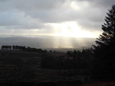
A steep climb out of the valley and I joined a lane overlooking Long Preston, one minute I could see it and next clouds and hail showers obscured the view. As I came out onto a road there was a bench perfect for an early lunch. I’m not sure why this road heading onto the moors is surfaced, there are no properties up there. On old maps it is Queen’s Road [? Elizabeth I ] and was the direct route from Long Preston to Settle over Hunter Bank before the turnpike road was built in the valley in the 18C. An old milestone was thus inscribed.

Dog walkers told me of the fine views up and down Ribblesdale, not today. Once over the top, I took to a direct footpath and a blurry Settle appeared below me. Little lanes, some still cobbled, thread their way into town. I took a coffee and dried out in The Folly, a late C17th manor house built by a wealthy lawyer Richard Preston.

I didn’t have time for more coffee and cake in the Ye Olde Naked Man, formerly an undertakers with a ‘naked man’ on the outside wall, 1663 covering his privates. There were more delights to discover off the beaten track in Settle. Narrow streets, quaint cottages, a Quaker burial ground and an old Victorian Music Hall.

I was aiming for a footbridge over the Ribble and then I would follow the river upstream past Stackhouse and Langcliffe Weir to Stainforth. The imposing large quarries at Langcliffe were in the gloom. I must be on a Long Distance Walk according to the signage. The going was muddy and by the time I arrived at Stainforth Falls, the light was fading. Sat-Nav is responsible for wide vehicles becoming stranded and damaging the old packhorse bridge.

I stayed the night in The Craven Heifer,  a friendly and comfortable inn. There are a number of pubs named after the Craven Heifer, a massive cow bred on the Duke of Devonshire’s Bolton Abbey estate at the beginning of the C19th.

The restaurant was fully booked for a Chinese New Year banquet but the chef was able to cook a fish and chip supper for me in the bar before festivities commenced. There was talk in the bar of a new virulent virus spreading in China.

The fish was significant as it was the only one I saw all day – remember the title of the walk. The loaves come tomorrow but the fish are the salmon seen in October/November leaping the falls at Langcliffe and Stainforth, not my battered variety.

Gung hay fat choy!

*****


VIRTUAL CLIMBING.

Last week I was tracing virtual walks on OS maps, the guides arrived and are promising. Today, still with the knee strapped, I’m following routes up rock faces, again in my mind. A few jolts to my memory of friends and climbs shared.

Going back 30 – 40 years I was climbing as often as possible – maybe 4 or 5 times each week. You are bound to become good and in my own world, I did.  My regular climbing partners back then became my best friends, where are they now?

I’m not writing here of those who have faded into retirement, all great friends whom I still see.

But these three are missed the most, routes and companions come to mind in vivid detail.

Tony, the gentle giant from the Yorkshire coal mines, Off we went to California on an adventure of our lives only to find our English ropes too short for Tuolumne granite. Replenished we tackled some great climbs in Yosemite. RIP

Pete, the haunted personality, with a reach far further than mine. A Cornish holiday stands out and that ‘one more route’ on Gimmer Crag which had him in deep trouble back at home. RIP

Doreen, the elegant mover and faithful belayer and now deeply into suffering Alzheimer’s.  I’ ve just managed a 100 hundred piece jigsaw with her today and that was far harder than her last route, Jean Jeanie.

I must fish out some old slides of these climbers and scan them. So many memories and tales to be told.

For a start a grainy shot, from my study wall, of the Ist ascent of Pinocchio at Craig y Longridge, Sept 1989, Doreen belaying.

VIRTUAL WALKING.

Since the successful weekend away with Sir Hugh walking our straight line, coast to coast, on Northing 438  there have been some sunny days and the forecast is for several more soon. I would expect to be posting some interesting walks. But no I have developed one of those annoying twinges in my right knee. I’ve strapped it up and I’m hobbling about trying to keep off my legs as much as possible. There goes the phone again and by the time I’ve reached it, the line is dead, probably a nuisance call anyway.

This gives me time to think about future trips but first I have to sort out some National Grid conundrums. Sir Hugh and I set off from Blackpool last year on the Northing 438  line, I called it the SD 38 but hadn’t realised that it would take us into the SE and then the TA squares, There were more 38 crossings in Britain so I had to be more exact. A little revision on the National Grid site was used to resolve the nomenclature.  I needed to re-evaluate my title. SD38 to SE38 to TA 38 was too cumbersome and inaccurate so I dropped the letters and used numbers only arriving at the more precise 438 Northing.  Interestingly I have an app on my phone that gives me my precise grid reference at any one point with the touch of a button, but that uses the lettered 100K squares, ie SD. Using ordnance survey maps if I click on a point I’m given both the latter and additionally the all number reference. I’ve also the app ‘whatthreewords’ which pinpoints my position in a more literary way. I didn’t realise I had so much technology at my fingertips. I should never get lost, if only life was so simple.

Anyhow now I know where I am – where am I going? Well, nowhere at the moment but I’m always dreaming.

I don’t want to be away for long as I have certain commitments at home. The LDWA has a very good, nigh on encyclopedic, index to any walks you may aspire to. The search system allows you to choose any length of walk in any area of the country. My two latest searches for three or four days came up with St. Hilda’s Way in North Yorkshire [40miles and designed as a pilgrimage visiting sites associated with St. Hilda] and The Cuckoo Way along the Chesterfield Canal from Derbyshire to Nottinghamshire [46miles along the 240-year-old canal.] A quick click on Amazon and the guide books are coming to my postbox. I think the latter may be most suitable for walking at this time of year. If my knee settles I should find a window of opportunity for the canal walk whilst Sir Hugh is occupied and then we will be able to complete our coast to coast.

Time for another Brufen and then I can continue following the routes on my maps.

NORTHING 438. SKIPWITH COMMON TO FOGGATHORPE.

The correct carpark was found this morning, 50metres down the road. We were the first arrivals and waited for a torrential downpour to pass. The start couldn’t be delayed any longer and waterproofs were needed for the light rain. We headed due east on a good track into the woods, mainly birch at this end with Scots pines further on. All around was heathland, waterlogged at this time of year, giving a pleasant start to the day despite the dampness. The information board states that this is one of the last remaining lowland heaths in the north. Longhorn cattle, Hebridean sheep and Dartmoor ponies graze it to help maintain the habitat. It must be a joy in the summer when the heather is in bloom.

Good progress was made on the easy tracks and soon we were in North Duffield, a rather undistinguished village though it did have a village green and pond. Down a side street was a hut adverting woodcrafts, Stan was busy inside and offered to make us anything from a pillbox to a Welsh Dresser. It would have been good to purchase something from this craftsman who had previously worked in church restorations.

We had been dreading the 2K walk on the busy A163 road, there was no pavement but most drivers gave us a wide birth and by now the sun had come out. In the distance to the south was the massive Drax power station one of several in this area of Yorkshire presumably established when the coal industry was at its peak, what future now?

Over to our left was another nature reserve, the Lower Derwent Valley, and we wondered whether we could have found a way by the river. People were walking their dogs along the embankment and bird watchers scanning the flooded fields [header picture]. Our stint on the road came to an end at the elegant bridge over the Derwent.

Bubwith had some period brick houses and an old church started in Norman times.

Whilst looking around the churchyard we found a seat overlooking the River Derwent for lunch. Looking at the map I notice that this river comes all the way from the North York Moors near Scarborough on its way to join the Ouse. There was a good view back to the bridge with its flood arches.

Originally when plotting a route I thought we would be stuck on the A163 a lot further but Sir Hugh had spotted an old railway line now converted into a trail. We gladly went slightly beyond our ‘mile either side’ limit to access it.

This was the route of the Selby – Driffield railway which closed in 1965. Work has been done recently to unearth Bubwith station platforms. On the way, we met a chatty man walking his dog who worked part-time counselling rugby league players at Castleford Tigers, sounds an interesting job. We steamed into Foggathorpe station ahead of the time table.

That was the end of our three-day jaunt on the 438 line, good walking each day and not a hill climbed or a Harry and Meghan mentioned.

*****

NORTHING 438. CHURCH FENTON to SKIPWITH COMMON (ALMOST)

In this area are scattered some delightful small villages of which we knew very little, a combination of limestone and red bricks giving each one a friendly feel. We are getting to know them and today visit several.

Church Fenton is a long village street with a community shop and a couple of pubs, one doing better than the other. My thoughts today were to photo all the pubs we passed but I kept forgetting. More importantly, there is a railway station. East Coast mainline trains rush through but there is a stopping service to Leeds and York adding to our thoughts that these villages are commuter dormitories.

We opt for a quiet lane rather than muddy fields around an old RAF aerodrome, there is no sign of life this morning.

Rather out of the blue in this flat landscape, we climb stairs to cross that main rail line, a couple of trains thunder through shaking the bridge alarmingly.

A quieter stretch through ploughed fields but fortunately on good tracks and we enter Cawood on the Wolsey Way, more of him later. The village is built around an old medieval manor site, the Garth, which the village own as an open space. We wander into it over a ditch which despite its modest size was used to transport limestone out of the area for buildings in Southern cities. The outline of a moat is clearly seen on the ground. Hidden behind trees is the original gatehouse to the castle and adjacent banqueting hall, the only traces remaining.  An information board tells the history; how the Archbishops of York owned it, how Cardinal Wolsey was arrested here for high treason and the link to Humpty Dumpty, and how the Garth was saved from development by the crested newt. https://en.wikipedia.org/wiki/Cawood_Castle

Through the town with its brick houses and narrow streets, two pubs with different fates.

We cross the River Ouse on a fine metal swing bridge which won’t be used for shipping very often.

Once across we use a path on the raised flood embankment into Kelfield with its closed pub and seemingly inadequate flood defences. Lunch is taken in a very comfortable bus stop. Several of the older buildings in this locality have moats and there is one to see just along the lane.

We progress on continued good paths alongside the prosaically named Main Drain, the water flow is considerable given the lack of a discernable incline. One has to be on the alert to mischievous gates. The Watermill Bridge is a bit of an anticlimax. Riccall is another interesting village with a large church.

Once on King Rudding Lane all we have to do is walk back to the car but there is more about this place than is obvious. An information board tells us of its ecology, coal mines, and a wartime aerodrome. The country park car park where everyone is heading is not where we parked this morning so we have more to find tomorrow.

Our walk is finished just after 3pm, ideal to drive back to our comfortable hotel in Hambleton, The Owl.

*****

NORTHING 438. BARWICK IN ELMET TO CHURCH FENTON.

It has taken us nine days to walk on our straight line, 38, Blackpool to Barwick last year. We are back in the maypole village this morning hoping to progress further along the grid line. It turns out to be worthwhile, unfrequented walking country, virtually all new to us, ideal for a short trip.

A quiet lane leads to Potterton where we pick up a bridleway heading across fields. On the map, there are numerous ridges marked as antiquities. People were building defences or just marking their boundaries from the iron age.  Our path goes along one of these ridges which are obvious on the ground, a ridge and maybe a ditch. The ridges have been taken over by trees and would probably be better seen from the air as is the case with most earthworks. Rather than keeping to the public footpath, we keep to the ridge as close as possible. Walking harmlessly along the edge of a field of cropped maize we are accosted by an angry gamekeeper. We plead innocence but he suggests that we have ruined the shoot for tomorrow. We actually only saw one pheasant fly out of the cover but we were not prepared to argue, we just accepted – mea culpa. Fortunately, we were by now almost back on the right of way. Close by guns could be heard loudly blasting away, enough to disturb any birds in the vicinity. Putting aside the question of shooting beaten birds we had already enjoyed the glorious sight of buzzards and red kites, hopefully flying without danger of being shot.

We emerged on an access road to Becca Hall, probably the owners of the fields we had been trespassing in. Another ridge, Becca Banks was followed into Aberford; this ridge probably protected the important ford during Roman times. The village once lay astride the Great North Road equidistant between London and Edinburgh.

A curiosity was the uniquely named Arabian Horse Inn.

The C19th  bridge, replacing the ford, over the River Cock is far larger than the present water flow warrants.

Further through the village, we should have visited the Gothic-styled Almshouses built by the Gascoigne family who had made their money from coalpits in the area.

Wikimedia

We couldn’t find a way under or over the motorway and ended up on a lengthy diversion to rejoin our route.

The fields are large here and planted with cereal crops. The soil had a tendency to stick to one’s boots. We found a rickety bridge crossing the fast-flowing River Cock which we then followed seemingly flowing uphill.

I wanted to visit the little church of St. Mary abandoned in a field where previously there had been a community. The chapel was open and exhibited some old wooden pews, a triple pulpit, an ancient font and old gravestones. It was a peaceful place and we took the advantage of a bench for some lunch in the sun, I’d forgotten to mention what a beautiful day it was.

The nearby Crooked Billet pub set us off on a debate as to the derivation – I suggested army beds, Sir Hugh pieces of wood. We were both correct, but why crooked?

Open fields headed towards Saxton and past a quintessential English pub next to the church.

This area is steeped in history but no more so than the Battle of Towton, in March 1461, a War of the Roses struggle that is said to be the bloodiest battle in English history.

Once we crossed a busy road a quiet lane through a golf course continued on a wide, open grassy trail.   We had to contend with the wettest field yet to enter Church Fenton where we failed in a roadside boot cleaning operation.

*****


OUT OF LONGRIDGE.

I wake to bright sunshine but take some time and coffee to get going. The health of two of my best friends is deteriorating; one with heart and kidney failure, the other with cruel dementia. I was talking to them both yesterday and it struck me that it doesn’t seem long since we were out climbing and walking together. So you have caught me in a pensive mood, not at all that  ‘happy new year’ feeling. I should have arranged a walk with one of my other friends for today – to ‘get me out of it’ but now it’s too late, I’ll just have to go myself which is not good for those introspective thoughts but I usually find the combination of sunshine and exercise clears my mind.

I’ve had enough of muddy fields recently so I’m happy to walk on roads for some much-needed exercise after the season’s excesses. Living where I do I’m lucky to be able to walk out my door and ascend a fell, in fact, the most southerly named fell in Britain, Longridge Fell. I’ve done it hundreds of times before. No matter there is always something new or worthwhile.  To start I spot a half dozen partridges running across the road in front of me, is it a covey or a bevy? And then a buzzard on the telegraph wires. After that, I seem to run out of wildlife sitings. Longridge is surrounded by water in the form of reservoirs and I pass the smallest one on my way out of town. Then I walk below the golf course which looks in fine fettle for winter but it must be a struggle in the wind, it is so exposed to the elements.

The road, the old Clitheroe road which kept to high ground, goes up and down towards the New Drop Inn. Few cars pass me. Turning the corner here I am walking in the footsteps of the Romans, this was their way from Ribchester to Carlisle.  The highest point on the road is reached near Cardwell House and looking back Pendle Hill looks as proud as ever. I bump into an old friend taking his dog for some exercise up the fell, we chat about all things local. This is his favourite hill and he’ll have his ashes scattered nearby. Coincidentally this is also one of my favourite viewpoints and my ashes will be here too, I told you I was in a morbid mood.  Years ago I asked a local artist, A Lord, to paint me the view from here over Chipping Vale with the Fairsnape/Totridge ridge in the background.

This painting is one of my prized possessions with its links to a past friend and to this great viewpoint. In the painting are the white iron railings that were a common sight on road corners around here to improve visibility for the motorist. They are slowly disappearing, I’ve always thought they should be listed as unique structures.

The weather was changing, dark rain clouds circling around the hills with the occasional rainbow over Chipping. Soon it was all downhill back to Longridge. Five miles with five hundred feet of ascent in one and a half hours. That’s how you clear your mind. Oh, and I found three good golf balls to boot.

*****

A LANCASHIRE MONASTIC WAY. 14. Ulverston to Furness Abbey.

                                                                          Furness Abbey.

I’m away early from Ulverston station. The footpaths are slippery with ice. Houses are soon left behind as I take a well-worn track down into a small valley and up the other side to Swarthmoor Hall. This C16 house belonged to Judge Fell and his wife, who befriended George Fox, founder of the Quaker Movement.  Fox bought a property around the corner to be used as a Quaker Meeting House with an associated burial ground. The hall was closed today, but I was able to wander into the grounds; it has an impressive set of bay windows on the east side. The Meeting House was also closed, and I could only peep through the gate.

Back on the route, a quiet lane, I have time to look around. There is that iconic tower above Ulverston with the southern Lakeland Fells behind, and down there is the Glaxo works and the Leven Estuary. Annoyingly, the low sun is directly in front of me, obscuring lower Furness. Once into fields, I look out for an Iron Age fort on Skelmore Heads to my right; I just about make it out on top of a low limestone escarpment. What a view, though. Down below me is a large tarn and the village of Great Urswick. On the way in, I chat to a farmer with a cage of ferrets; I haven’t seen one for years, yet all my uncles used to have them for catching rodents.

The village consists of lots of interesting cottages surrounding the tarn, a well-hidden gem off the beaten track. I knew of the church, but I first came across one of those ‘tin tabernacles’ erected in 1915 and now used by the United Reformed Church.

The Parish Church of St.Mary and St. Micheal was along the way, hidden in trees. It is reputedly the oldest church in Furness, maybe 10th Century and predating Furness Abbey. The outside looked old, but inside was much changed. When I entered, there were two local ladies giving the church a good clean, hoovering and polishing. Work stopped as they gave me a guided tour of the interior. Of note was an ancient C9th cross, wood carvings by Alec Miller in the 1910s, a triple-layered pulpit with a sounding board, some interesting stained glass and a C18th painting of The Last Supper by local artist James Cranke, who was a tutor to a young Kendal artist George Romney. Onwards, this is going to be a long day; I take old byways to Little Urswick and then climb the limestone escarpment of Urswick Crags. I’m interested in the ancient settlement marked on the map and need GPS to locate it. Two areas of stone walls are found, one squarish and the other circular, amongst the limestone outcrops.

Great Urswick and Tarn with Skelmore Heads and my descent track behind.

Ancient track.

Ancient settlement.

Once over the crags, I pick up an enclosed track ahead with Black Coombe in the distance. The soil now has changed to the red colour normally associated with Furness, and it sticks to your boots. Changing direction to Standing Tarn. The water level is high.

I’m glad to escape the heavy red soil and walk on roads into Dalton. Rows of cottages were built for the iron ore miners back in the late C19th, now upgraded with satellite dishes and cars.

The middle of town is a conservation area, but many of the old buildings have been mutilated by commercial development. Things are better from the Market Square upwards, with the castle tower and church dominating the scene. Lots of cottages with several courtyards. The Castle Pele Tower was built by the monks of Furness Abbey in 1330 as a place of refuge. The  Church of St. Mary was designed on the site of a much earlier church by that well known architectural firm, Paley and Austin, in 1885. Built with sandstone with chequerwork decoration. The lane by the church takes me out of Dalton through fields towards my final destination, Furness Abbey. I walk down a road to an entrance gate into Furness Abbey. It is closed, but I can walk around it on a public road. A Savignac abbey was established in Tulketh, Preston, in 1123 but moved north to this Furness valley and was later absorbed by the Cistercians. To reach here, the traveller had to cross the tidal sands of Morecambe Bay and the Leven Estuary. The abbey provided guides for these crossings. Despite the aspirations of the Cistercians to lead a simple and austere life, acquisition of wealth, property, and trade soon made Furness Abbey second only to Fountains Abbey in riches. At Dissolution, the land was given to Thomas Cromwell and later transferred to the Cavendishes of Holker Hall. Now the ruins are in the hands of English Heritage. The main ruins include the church and cloisters, as well as dormitories, an infirmary and lay buildings, all laid out in classical monastic style.

The setting in this valley and the extent of the remains make this a fitting end to my Monastic Way through the ‘old’ Lancashire. Well, almost, for I have to walk further south to a rail station. A green valley has a fine little stream and over it is the medieval three arched Bow Bridge built for the monks to access a mill. I’ve explored many unknown areas, met some very friendly people, learnt a bit more history, visited fine religious sites and completed before the year’s end. Here’s to 2020.

*****