Dean Clough Reservoir.
I buy far too many books; I’ve a little stash awaiting my attention this winter. I’m currently reading Alan Cleaver’s ‘The Postal Paths’, a loving look back at the ways our rural postmen used to travel before they were issued with vans. That particular purchase stemmed from my attempt to follow one of our local postie paths under the fell.
In the past, I have often been inspired and guided by publications from Cicerone Press. Set up way back by two Lancashire lads, Walt Unsworth and Brian Evans, climbers and walkers who had a flair for researching routes and producing damn good guidebooks for the rest of us to follow. I would hazard a guess that you will have one or more on your bookshelf.
Their regular newsletters appear in my digital newsbox. For November, they were tempting me with 20% off all their catalogue. My ambitions are limited these days, so aspiring treks in far-off places I can ignore, but a newish series of Short Walks in various UK destinations caught my eye. A few were promptly ordered. In the bundle that arrived yesterday was one on the Ribble Valley, which was only just published this year and written by Mark Sutcliffe, whom I respect as a trusted guidebook author. Okay, I have probably walked the Ribble Valley to death, but I am always curious about how others approach it. 
Walk No. 5 – Dean Clough Reservoir seems an ideal, fairly local walk for these short days between the showers. Today, the rain isn’t forecast until three this afternoon. Yes, I’ve walked this particular area several times, but Mark gives a new twist to the familiar and maybe paths that I have never explored. I didn’t know one could walk the south side of the reservoir, and who doesn’t love navigating a golf course?
One advantage of Cicerone is that once you have purchased one of their guidebooks, you can download a GPX file of the route onto your phone. Of course, I forgot to do that today, but it is not necessary as the book has good OS mapping and an accurate description of the route.
Time to get walking. In fact, it is just before midday when I park up at an abandoned Indian restaurant in Langho. The last time I came this way, I arrived by train, which is a more sensible approach. But needs must.
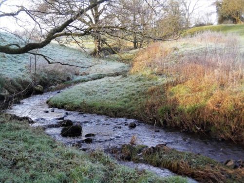
I know the way up a residential road to where the footpath sneaks behind the last house and attempts to follow a stream bed, which is slowly, or perhaps rapidly, eroding away. Today, with the slippery leaves, it becomes a bit of an obstacle course. The obstruction caused by a fallen tree, which I encountered last time, has been cleared, but the path now seems more precarious. Of course, I emerge onto the lane at York unscathed.


It’s still all uphill past the cottages. Locals stop to chat, and I struggle to catch my breath. 
The Lord Nelson pub is left behind as I climb another steep lane. More locals join in; this is a popular walk. I stop to look back across the Ribble Valley to Longridge Fell.
Through a gate, I end up on the open common of the ridge with no name. Rather than head up to the rocks along with everybody else, my way slants across to the right, passing some tough-looking ponies, before rough ground down to the bridleway above Deans Clough Reservoir. Yes, there is rain in the air. 


I follow this up to the prominent band of trees on the hillside. Doesn’t gorse brighten your day, whatever the month?


I’ve traversed this way several times, but as I said, I was unaware that there is a permissive footpath along the south side of the waters. So that’s where I head. A decent path provided by United Utilities skirts the shore all the way to the dam, leaving you to enjoy the views right through to Pendle. One can never get away from Pendle in the Ribble Valley. I’m not sure why the reservoir has a dividing weir, but it appears that you can walk across it. 


Across the main dam, I climb back up onto the ridge, but instead of heading back down to York, I veer right towards Whittle Hall. From up here, trying to ignore Pendle, there are views back across hidden East Lancashire.


The buildings of Whittle Hall are navigated surprisingly easily, and now for the golf course. 

So I just follow the black and white posts; there doesn’t seem to be any golfers out. But what a view they have over to Kemple End. The ground is treacherously wet; crampons or at least golf studs would be of help. Soon, however, I’m in an old byway—Doctots Rake, avoiding all the fairways. I wonder how that name originated. 


Once over the railway, I pass the clubhouse, but don’t seem to find a way in for that promised cup of coffee. 


Not to worry, I’m back at the car in ten minutes and home in twenty. What a good choice for a Short Ribble Valley walk. 
And today, storm Claudia is creeping past, and bits of my roof are falling off..
*


 Instead, the guidebook takes a different route through the villages of Herringwell and Tuddenham, where a version of the Icknield Way may have gone.


 And I do always like Staffordshire tiles.


 They are trying to preserve the heathland, which is man-made in the first place. Agricultural practices over the centuries have been preventing tree growth.


 Big open skies to the north, from where I could hear but never see planes. Turns out there is an American air base up there, Mildenhall.


 I pass by the modern flour mill, with its interesting history. One of my sons is a baker.


 By the time I get to the top, I’m virtually in the clouds. A silence has descended on the fell. I enjoy the solitude.


 Driving back down the fell road, I see a glimmer of brightness over the Lancashire plain against the mug on the fell.


 I take the long way round to view the remains of the Spencer Kilns first, on the upper side of the site below the looming quarry above.