Tag Archives: Longridge Fell

A GLOOMY LONGRIDGE FELL.

With all this wet weather I’ve become obsessive about keeping my feet dry and out of the mud so today I walk up Longridge Fell on forest tracks and return on the road. I’m still restricted to a few hours in the day so It suits me to do another short walk whilst the weather is dry. I’m following a popular dog walking trail, I can tell that from all those black plastic bags by the track but I don’t want to spoil my walk by becoming angry so I ignore them. Every time you come up here there has been more tree felling changing the nature of the walks. They seem to plant new saplings amongst the debris of the felling without worrying about the remaining stumps.

There is evidence of the strength of the recent storms with trees casually uprooted. Onwards and upwards I go, I have no intention of getting my trainers dirty by going to the summit, I’m content getting some exercise on the tracks. I detour to a viewpoint towards the Bowland Fells which I always enjoy. These are size 12s if you need any.

Back on the main track, it starts to descend in sweeping curves, would be great on a mountain bike, towards Kemple End with Pendle In the distance. On reaching the road all I have to do is turn right and follow it back to my car less than two miles away. I normally avoid roads when there are alternative paths but this quiet highway turns out to be pleasantly undulating with views to the south. It certainly serves the purpose of keeping my shoes clean and dry. Halfway along is a small stream, Brownslow Brook,  coming off Longridge Fell which appears to be culverted into a water collecting plant, I’ve never noticed it when driving this road and I can find no clue to its function. I’m back home for lunch thinking it was probably me rather than the fell that was gloomy.

*****

OUT OF LONGRIDGE.

I wake to bright sunshine but take some time and coffee to get going. The health of two of my best friends is deteriorating; one with heart and kidney failure, the other with cruel dementia. I was talking to them both yesterday and it struck me that it doesn’t seem long since we were out climbing and walking together. So you have caught me in a pensive mood, not at all that  ‘happy new year’ feeling. I should have arranged a walk with one of my other friends for today – to ‘get me out of it’ but now it’s too late, I’ll just have to go myself which is not good for those introspective thoughts but I usually find the combination of sunshine and exercise clears my mind.

I’ve had enough of muddy fields recently so I’m happy to walk on roads for some much-needed exercise after the season’s excesses. Living where I do I’m lucky to be able to walk out my door and ascend a fell, in fact, the most southerly named fell in Britain, Longridge Fell. I’ve done it hundreds of times before. No matter there is always something new or worthwhile.  To start I spot a half dozen partridges running across the road in front of me, is it a covey or a bevy? And then a buzzard on the telegraph wires. After that, I seem to run out of wildlife sitings. Longridge is surrounded by water in the form of reservoirs and I pass the smallest one on my way out of town. Then I walk below the golf course which looks in fine fettle for winter but it must be a struggle in the wind, it is so exposed to the elements.

The road, the old Clitheroe road which kept to high ground, goes up and down towards the New Drop Inn. Few cars pass me. Turning the corner here I am walking in the footsteps of the Romans, this was their way from Ribchester to Carlisle.  The highest point on the road is reached near Cardwell House and looking back Pendle Hill looks as proud as ever. I bump into an old friend taking his dog for some exercise up the fell, we chat about all things local. This is his favourite hill and he’ll have his ashes scattered nearby. Coincidentally this is also one of my favourite viewpoints and my ashes will be here too, I told you I was in a morbid mood.  Years ago I asked a local artist, A Lord, to paint me the view from here over Chipping Vale with the Fairsnape/Totridge ridge in the background.

This painting is one of my prized possessions with its links to a past friend and to this great viewpoint. In the painting are the white iron railings that were a common sight on road corners around here to improve visibility for the motorist. They are slowly disappearing, I’ve always thought they should be listed as unique structures.

The weather was changing, dark rain clouds circling around the hills with the occasional rainbow over Chipping. Soon it was all downhill back to Longridge. Five miles with five hundred feet of ascent in one and a half hours. That’s how you clear your mind. Oh, and I found three good golf balls to boot.

*****

WAINWRIGHT’S WAY. 3. LONGRIDGE FELL TO DUNSOP BRIDGE.

Across Chipping Vale.

Here I am back at the trig point on Longridge Fell, it is a beautiful, cold but sunny Autumn day. Sir Hugh has joined the fun and we’ve taken one car to Dunsop Bridge and driven back to park below the fell. I’m sorry we are not keeping to AW’s use of public transport.

A warm-up walk and a catch-up chat soon sees us on the ridge with the compulsory visit to the summit trig. A few people are wandering about up here not wanting to miss the good weather. After a photo session and orientation of distant hills, mainly the Fairsnape ridge, Bowland and the Three Peaks, we find the steep rake dropping down into the Vale of Chipping, spread out below us. Our distant destination of Dunsop Bridge visible in the folds of the fells. This brings us to the road next to the Bradley Hall complex of buildings. WW says to go through the complex but our more modern map says go round the diversion to the left. This is the start of troublesome field navigation for the next mile or so. The waymarks run out, the paths run out, the stiles disappear, the fields get boggier and we are left to our own devices, no fences were damaged, no wires cut when we finally stumbled down a ladder stile onto the road next to Doeford Bridge. I think it took us longer than we realised.

A sign tells us we are entering the Queen’s land which we enjoy for the rest of today

.

This beautiful sandstone bridge spans the Hodder just downstream from where the River Loud joins having come out of Chipping Vale. The bridge is sketched in AW’s Bowland book.

Doeford Bridge. 1981. A Wainwright

There was a good volume of water today after several days of heavy rain. Having crossed another field we dropped down to the Hodder which had looped round a different way.  I wanted to have a look at the stepping stones next to Stakes farm so we made the short diversion, there was no way you could have crossed the river here today. Luckily we found a bench overlooking the river and stopped for lunch.

AW?

Behind us was Stakes Farm an early C17th house with mullioned windows and a plaque in Latin, translation please. Amazingly a brick extension has been built into the angle between the two wings.

We follow fields just above the river. The area between Longridge Fell and the Bowland fells is beautiful and unknown countryside, especially in today’s sunny weather, backed by the dark hills. Across the river used to be a ‘Wild boar park’ but it has closed recently. We cross the road into more fields running above the Whiewell Gorge where the river runs deep in the woods. [It is on the opposite bank that you can find the Fairy Hole caves.] Views into the Bowland Fells surrounding Dunsop Bridge keep us going.

I think we are following one of the aqueducts taking water out of the to industrial Lancashire, the distinctive Waterboard gates accompany us. We drop down past a graveyard and pop out onto the road next to the famous Inn at Whitewell. There is time to have a look into the adjacent Church of St. Michael with its striking stained glass window.  We resisted calling at the inn as time was drifting on and I think once seated it would have been difficult to get going again. A permissive path close to The Hodder leads deeper into Bowland with the next feature sketched by AW – Burholme Bridge.

Above us on the right was the distinctive Birkett Fell scene of one of our recent struggles. Our pace was slowing and instead of the familiar track by the river to Thorneyholme we crossed the pipe bridge, erected by Blackburn Borough Waterboard in 1882. with its unusual turnstile gates at either end. The way along the river was convoluted as we bypassed Root Farm famous for Kettledrum, a Derby winner bred hereabouts. Our arrival into Dunsop Bridge was unfortunately too late to have tea at Puddleducks Cafe.

Dunsop Bridge.   A Wainwright 1981.

We reflected on this wonderful crossing of Chipping Vale, Lancashire at its very best but wondered why 8 miles seemed so far. I was glad I’d divided this stage of WW into two enjoyable days, days to be savoured.

Here is an evening photo of the rake we descended from Longridge Fell early in the day.

Possibly Sir Hugh may have a different view of the day.   http://conradwalks.blogspot.com/

*****

WAINWRIGHT’S WAY. 2. WHALLEY TO LONGRIDGE FELL.

The Ribble at Dinckley.

A Ribble Valley walk of history, graveyards and conversations along the way.

As I wait for a bus to take me to Whalley a lady of a certain age enquires as to my journey, I’m in boots with a rucksack and attached walking poles.  When I tell her of crossing the Ribble at Dinckley Bridge she recollects a time when a ferryman would take you over for a penny. It was like that in AW’s early years when he explored the Ribble Valley north of his home in Blackburn.

My bus deposits me in the middle of busy Whalley at 12.30, I’m a late starter these days. Wainwright’s Way takes me past the ancient parish church, I make a mental note to revisit between 2 and 5 when it is open. I do however make the effort to seek out some Saxon crosses in the churchyard.

I walk past the Abbey grounds which I visited last weekend.   The lane out of town actually goes through the oldest West Gate.  It has an impressive ceiling but is somewhat diminished by the road passing through it. Almost immediately you pass through another arch, that of the railway viaduct, the longest and largest in Lancashire. 48 arches of immaculate brickwork. A functional ‘Old Sol’s Bridge’ crosses the Calder River, built in 1993 to replace the 1909 one of Solomon Longworth, a local mill owner. Backstreets of Billington, old and new, take me out through horsey country to cross the A59 and into a more rural scene. I wander across fields which have the clearest signing and stiles  I’ve come across, an example for other farmers to follow.  Although I’m aiming for Longridge Fell in the distance the view of Pendle behind me is ever present.

I recognise Old Langho Church, built using stones from Whalley Abbey after the dissolution. I take a picture to compare with AW’s Ribble Sketchbook.

A Wainwright. 1980.

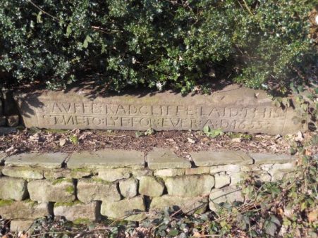
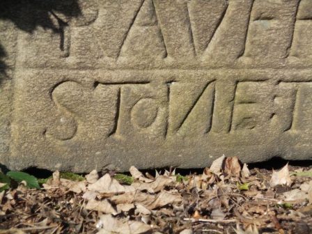
I then make the effort to seek out, in a far graveyard, the memorial to 600 who died in the nearby Brockhall Hospital. The tablet is inscribed …

‘In an isolated institution located to the northeast of this stone there lived from 1904 to 1992 a large number of people who were thought to be too strange, too difficult or too challenging to be cared for in their own communities. The institution, in turn, was called Lancashire Inebriates Reformatory (1904) Brockhall Hospital for Mental Defectives (1915) Brockhall Hospital for the Mentally Subnormal (1959) Brockhall Hospital for Mentally Handicapped People (1974) and Brockhall Hospital for People with Learning Disabilities (1991). Although those who lived there carried heavier burdens than most they were part of our common family.

‘Brockhall Hospital closed its doors in 1992 and the land on which it stood was acquired by Gerald Shimon Hitman of Newcastle upon Tyne who raised this stone as a memorial to those who ended their days in the hospital and are buried here. God full of compassion grant perfect rest beneath the shelter of your presence to these your children who have gone to their eternal home. Master of mercy, cover them in the shelter of your wings forever and bind their souls into the gathering of life. It is the Lord who is their heritage. May they be at peace in their place of rest.’

Poignantly, Gerald Hitman, mentioned on the memorial is buried nearby.

I pop into the old Bull Inn for a pint but am dismayed at the internal  ‘improvements’ that have totally destroyed the place. What a shame, another pub ruined, I shan’t be returning.

The footpath now goes alongside a development of ‘luxury lodges’ extending into the open countryside. A lady occupant says that they are holiday lets but that quite a few are permanent homes. How to get around our flimsy planning regulations. Another field ruined.

A steep drop leads to a hidden footbridge over a lively Dinckley Brook. I’ve never been here before. Soon a lane is reached, the line of a Roman Road from Ribchester to Ilkley. At a farm along here, I watch as a golfer practises his drives across the fields, he has spent his life as a dairy farmer and only now has time for leisure pastimes. He too remembers, as a child, the ferry at Dinckley and much more.

At last, I’m on the lane dropping to the Ribble, Longridge Fell is ahead.  Two local ladies on their daily walk are also keen to chat refreshingly about the area until they realise they have to rush for the school pickup.

Dinckley Hall is too far away to observe behind ‘new’ barn conversions but the new shiny bridge is glimpsed below replacing the suspension bridge damaged by floods. The river scenery here is stunning and timeless. [heading photo]

A Wainwright. 1980.

Over the bridge The Ribble Way is joined – an ill-fated long-distance path but with perhaps the best-designed logo The lane up to Hurst Green goes on forever but there is an inn at the top if required. From up here, there is a view back to Whalley NabI had a snack sat on a bench next to a war memorial cross which unusually refers to The Boer War. It is inscribed – This cross commemorates the services of Frederick Sleigh first Earl Roberts K.G.V.C.and his companions in arms the soldiers and sailors of the Empire who fought in the South Africa Campaign 1899-1902.

Opposite on a small roundabout is the WW1/WW2 memorial. Higher in the village are the Shireburn Almshouses, sketched by AW, but when he was wandering this area as a youngster were still up on Longridge Fell. Erected in 1706 but removed and rebuilt in 1946 in the village providing accommodation for Stonyhurst employees. I’ve never discovered why they were high on the fell in the first place.

Hurst Green Almshouses.

A Wainwright. 1980.

Stoneyhurst College is intricately associated with the village and much has been written about it.  Up the road, circumventing the graveyard, The Our Lady Statue looking down the avenue to the College has been restored and is shining bright, I think I preferred it as before. It is not marble but steel painted white. That famous view is also timeless, that’s not me yomping up the road.

My accent of Longridge Fell continued by picking up an old bridleway, a favourite of mine, alongside lively Dean Brook with its old bobbin mills and then past buttressed Greengore, an ancient hunting lodge.

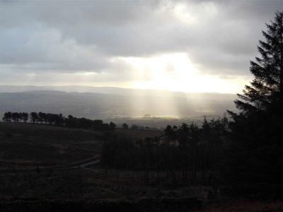
The day was passing and the forecast predicted rain by 5pm.  There has been a lot of change up here with storm and fungus damage to the trees so I used local knowledge to find my own familiar tracks to the summit. The Bowland Hills across the Vale of Chipping were darkening and rain was spreading across the Fylde towards me. I reached my previously stashed cycle and hurtled down to Longridge just in time. I shall regain Wainwright’s Way at the summit trig point when time and weather allow.  Bring on Bowland.

*****

KEEP IT SIMPLE.

Beacon Fell.

Beacon Fell, Brock Bottoms and Kemple End.

It’s the summer holidays and I’m entertaining my youngest grandson for a couple of days, that’s all he has in his busy diary. I think of some local walks that will keep him interested and not be overdemanding. When I was his age, 11years, I could cover 20 miles no problem across rough moorland, alone and while smoking a few Woodbines.  Maybe not, but I think the generations have softened the Human Spirit. While he stays with me there is an unplugged mentality regarding mobile devices, I try to explain that nothing will happen whilst he is off line. He is not convinced.

He arrives with his stepmother, both keen to explore the local countryside. I’ve devised a route up onto Beacon Fell that is interesting, short and easy. They seem happy with it as we arrive at the cafe in time for lunch. On the way we passed Barnsfold Reservoir where his great grandad used to fish and paint piscatorial images for the fellow fishermen. I’ve often wondered what happened to those skilled canvases.  We marvelled at the size of two Buzzards wheeling overhead and we wondered about unusual tree fungi, a white bracket on a beech tree which I’ve been unable to identify.

We walked past a farm where the family have diversified into a hair salon what was previously a cowshed, good on them.

We passed more fishing lakes this time part of a recreational complex with holiday chalets. The original farm, Wood Fold, is grade II listed but has been submerged by ancillary housing.  I never realised how much-hidden developments there were in the area.  There was only a minor footpath diversion through this development.

Onwards, with grandson navigating, we followed my route of the other day through Crombleholme Fold and up the fields and into the woods to the honey spot of Beacon Fell.

All smiles.

We were probably the only people that had walked here, all be it only a  couple of miles. A trio of elderly cyclists arrived and clattered into the cafe, they had come through the hills from Lancaster. We enjoyed soup and sandwiches. On our way back we had time for an attempt at climbing the new snake from tail to head and then we were out of the woods and back at the car. There were some new wood carvings of leafy Green men, a pre-Christian symbol. Incidentally, there is a Green Man Pub in nearby Inglewwhite.

I hope that a few navigational skills have been absorbed.

The afternoon was spent pruning bushes in my garden and the more exciting shredding of those branches which provided lots of laughs. A competitive game of boules anticipated our imminent family trip to France.

Refreshed by Thursday morning our next jaunt was to Brock Bottoms just below Beacon Fell. We were one of the first cars parked up in the popular picnic spot.  It is years since I’ve been along this stretch of the River Brock. Memories of early forages with my own young children keep coming back. The river is low, we see no kingfishers or dippers which I was hoping for.

The highlight of this walk was going to be Brock Mill but alas time has taken its toll on the ruins of the mill. Where there had been substantial buildings there were only stones with little evidence of the mill race, waterwheel or the mill itself.

Brock Mill was once a thriving water-driven cotton spinning mill with up to twenty cottages in the valley for the workers.  The mill was probably built in the 1790s. After a chequered history and two reincarnations as a roller making factory, and then a file making factory the mill finally closed in the 1930s. For some time the ground floor of the mill operated as a café, whilst the top floor was used for dancing on Saturday nights!

It took some imagination to see the ruins of the cottages.

Slightly disappointed we retraced our steps. Having given my grandson a lecture on watermills I drove back via Chipping where there is a water wheel attached to a house, a former corn mill and then converted to a restaurant with the wheel turning.

I cut the lawn whilst he caught up on ‘social media’, he hates it when I call it ‘antisocial media’

The weather remained sunny and dry and the plan for the afternoon was some bouldering up on Longridge Fell. Again keeping it low key I bypassed the tough Craig Y Longridge and settled for Kemple End. We dropped into the secluded heather bowl that is the old quarry. We were out of the sun and spent a couple of hours trying some of the easier problems. He realised that outdoor climbing is so different to the climbing walls he has been visiting. At the end of the session, I’m not convinced I’ve converted him into a proper climber. I was so busy spotting him that I didn’t take any photos – next time.

I don’t know who was most tired by the time his father came to take him home. See you in France.

TOTRIDGE FELL, BOWLAND.

 Last night after a bouldering session at Craig y Longridge I drove up the fell and took in the familiar view over Chipping Vale to the Bowland Hills. In front of me were the Fairsnape, Wolf, Saddle, Burnslack and Totridge Fells. How many times have I photographed this scene?  I’ve not been on the easterly of these for several years so there and then I decided on a full traverse of the range today. For every 100 visitors to Fairsnape there is probably only one on Totridge.

I can’t explain why I sat in bed with a couple of coffees delaying my departure. Sloth had taken control and it was with a great deal of difficulty that I finally emerged and started the walk at 11am. By then I realised a full traverse and return of 13 miles or so was impractical and I opted for a shorter 9miles from Saddle End, missing out Fairsnape. The heat of the last few days was diminished by a westerly breeze. Old tracks rise up from Saddle End farm and soon the open moor is reached. A steady metronomic pace is tapped out by my walking poles as I gain ground. There is not a soul in sight.

Saddle End Farm and fell.

On the 26th March 1962 three siblings left home and travelled by bus to Chipping and
walked over the fells, maybe to Langden Castle, on their return over Saddle Fell they were caught in a blizzard which resulted in the two brothers losing their lives due to hypothermia. Their sister survived to raise the alarm at Saddle End Farm. There was no Mountain Rescue Team in the area at that time so police and locals searched with BAC loaning a helicopter to help. Shortly after this tragedy two Mountain Rescue teams were formed in the area, the forerunners of Bowland Pennine MRT.

I mention the above because it is thought the boys may have sheltered in a small stone hut. I remember early walks on Saddle Fell in the 70’s the hut being by the track I’m on today, its roof was almost intact. Now it is a pile of stones but with a tragic history which I recollect every time I pass.
Reaching the wild top of Saddle Fell ignoring the track to Fairsnape I turned east at the watershed to follow the fence towards Totridge seen a couple of miles away. This stretch of fell is usually one of the boggiest in the area, I’ve been pulled out of the depths on one occasion,  deciding which side of the fence is the least hazardous often means crossing repeatedly without any real advantage. Today however the peaty ground was bone dry and I could just enjoy the scenery without any risk of sinking, the wooden poles placed to give buoyancy in wet conditions totally unneeded. [By the way the best ‘path’ is on the left of the fence.]

The views are far stretching over the Bowland area and all the hills and valleys I’ve been walking recently are identifiable. The Yorkshire Three Peaks are in the hazy background. Difficult to capture on camera.

Up here in this bleak wilderness one plant brightened up the peat bogs – the yellow starry flowered Bog Asphodel.

All I had to do was follow the fence, there is one pond to navigate found and a short section above Whitmore where you leave the fence at a tangent and take off into the peat to regain a wall in a short distance before rising onto Totridge and a final open track to the trig point at 496m. The trig pillar is looking decidedly unstable as the peat below it erodes, it will topple before long.

From the top a small path, not marked on the map, heads NE to drop steeply off the fell towards Mellor Knoll. If the correct line is taken zigzags descend quite pleasantly, not so pleasant ascending.  Halfway down today I found a place to sit, eat my sandwiches and contemplate the views over the Dunsop and Hodder valleys. In the distance over Mellor Knoll was a glimpse of Stocks Reservoir I walked around last week and closer at hand, above the Hodder, the tree capped Birkett Fell again climbed recently.

Over Mellor Knoll to Stocks and Yorkshire.

Birkett Fell, Waddington Fell and distant Pendle.                                                       

I dropped down to the fell wall and joined the bridleway coming from Hareden which goes into woods of beech and chestnut where I met the first people of the day, three gents enjoying the area.

My way back was on a series of bridleways and paths linking remote farms in the limestone country below the fells. Higher Fence Wood, Dinkling Green and Lickhurst. From the latter the track went further back up into the fells than I remember and I speeded up a little as bad weather was coming in.

Lickhurst Farm.

I used to cycle these ways when my children were getting into mountain biking, I don’t remember these stepping stones by a ford below Burnslack.

I arrived back at the car just as the rain did, my dilatory start almost catching me out.

*****


MID-SUMMER MISCELLANEA.

Double rainbow over Longridge out of my window.

Haven’t much to report since arriving back from France, how can I be jet-lagged after an hour and a half flight.

The fields opposite my house are being cut by a flotilla of agricultural vehicles, what a contrast to the old days of hay cutting that I was involved with as a youngster.

The weather here has been predictably hot and dry so I’ve been out bouldering on Longridge Fell at three of my favourite crags – Kemple End, Crowshaw and of course Craig Y Longridge.  These three give me choices of sun or shade at varying times of the day so I can escape the sun if needed. Up at Kemple I ventured onto Hodder Buttress to solo the easy slabs and arriving at the top I was concerned about some loose flakes above the climbs, I had great fun trundling these onto the quarry floor thus making the routes safer. Over on the main wall I found that I was struggling on some of the traverses I normally cruised, I blamed this on lack of confidence since my enforced layoff. The view over the Ribble Valley this evening was splendid.

At Crowshaw I was completing a topo of the problems to the left of the main buttress. The quarry bowl here is a delight as the heather starts to bloom and the bilberries ripen. I am content on an evening just to sit here and listen to the bird song.

After these two backwaters Craigy is hardcore bouldering, 100m of overhanging rock, with a regular clientele. I have a section at the far end that is less severe and I can do circuits on relatively good jugs to keep fit.

Whilst up on the fell I popped into Cardwell Quarry where climbing is now banned because of unsociable behaviour by some ‘climbers’. I was surprised to see that not too much vegetation has returned in the lean years. I must go and have another word with the farmer to try and restore climbing here.

I was out in the Ribble Valley today and popped into Witches Quarry. A secluded limestone venue where you drive into the field and park conveniently under the crag! The rock was in good condition and I traversed a little and then soloed the amenable Cracklap, I’m sure this used to be VD. Strangely a gooseberry was growing from the start of the crack.

A SUNDAY MORNING STROLL.

I can’t say much new about Longridge Fell.

Over coffee I was plotting a route from Brock Bottoms when the phone rang. it was Dave asking if I fancied a walk on Longridge Fell. I couldn’t say no. I’ll put the river walk on hold.

I’ve not seen much of Dave since my PMR episode put rock climbing on hold, and anyway he is abroad most of the time. A quick turn around and we met up at Cardwell House car park at 10am.  He was not familiar with this western end of the fell so I had hoped to give him a good tour. We caught up on our recent relevant excursions. He has just had a successful three week’s climbing trip to the south of France, I’ve mainly been at the doctors. As I waited at the car park I tried out the panoramic mode on my camera with the Bowland Fells over Chipping Vale.

He seemed to be enjoying the route I took trough the forest until we hit an area of tree felling across the track, the next 200m was tedious to say the least. He likened it to anti tank defence terrain from the 2nd WW.

We eventually emerged onto a familiar track up towards the summit but a blocked path forced us onto another rough section.

The views from the trigpoint were exceptional but we didn’t linger as we had already taken much longer than anticipated.

The way back to the car traversed the fell overlooking the Vale of Chipping again on a track he had never used.

It was good to catch up.

*****

The weather was so good that I decamped to Craig Y Longridge on the way home for a bit of bouldering and more catching up with friends who were there, it was busy.Just across the road on a small reservoir a pair of great crested grebes have set up home in reeds within sight of the road. The female is sitting on three eggs so far and the male fussing around extending the nest.

LONGRIDGE FELL WANDERINGS.

A rather gloomy Longridge Fell with Pendle in the background.

I rose Phoenixlike from the ashes for a stroll on Longridge Fell. I had not been out for a month due to some chest infection or other and I wheezed my way round today. The weather was not the promised spring sunshine, in fact I wished I had donned an extra layer to cope with the cold wind.

I chose an anticlockwise circuit for some reason but before long this was denied to me by forestry work on wind-blown trees that had closed some paths. Over the last few years there has been a lot of tree felling partly due to fungal diseases attacking the spruce, and the edges of the remaining trees are susceptible to strong winds. I lost a Blue Spruce in my own garden two years ago and wonder whether I brought the disease back from the fell.

The diversions led me into parts of the forest long forgotten and rarely visited.

My favourite tree on the fell.

Approaching problems.

No further.

Deep in the hidden parts.

On the way back I enjoyed a  long open section past the trig point with decent views into Chipping Vale and across to the Bowland Hills. I met the only people I’d seen all day flying an extremely fast model glider.

The Bowland view.

What’s eating this?

The modern non-edible variety.

It was windy.

You can see from my plotted map that I walked an erratic route with some backtracking but managed 7 miles which pleased me.

*****

SKIPTON TO LONGRIDGE 4 – A sunny Longridge Fell.

Longridge Fell from the south, Kemple End is the steep bit at the right.

Higher Hodder Bridge to Longridge.

JD and I are sat in the bus station at Clitheroe waiting for the Skipton bus to arrive with the pieman on board. The alloted time passes and we wonder if we are in the right place, we circle the area in our car but no sign of him or the bus. The phone call elicits that the bus broke down! We look at each other and as the day is dismal and I lack enthusiasm we drive home  for other pastimes,  ie gardening.

Fast forward 24 hours and we are sat in Clitheroe bus station once again. I must admit the weather was far better today so we hoped the pieman would arrive. He did and within 10 minutes we are parked up at Higher Hodder Bridge at the base of Kemple End, the east end of Longridge Fell. After a stretch by the Hodder we start a fairly easy zigzag ascent of the fell. Behind us were views across the Ribble Valley to Pendle and Waddington Fell. We emerged at the road and stripped down to shirts for the rest of the 1000ft ascent in increasing temperatures.

Higher Hodder Bridge.

Climbing Kemple End, Pendle in the background.

Layers coming off.

A mixture of tracks and paths through the forest where there has been a lot of clearances of late, a magic route opened up in front of us. The lighting seemed to transport us to some alpine approach but there were no snowy peaks above. Familiar tracks head up the fell though in some places wind damaged trees create diversions. We came out of the trees at a well known viewpoint overlooking Bowland, the Three Yorkshire Peaks were in haze.

Magic light amongst the trees.

There is a way through.

More uprooted trees.

That viewpoint.

Our guest from Yorkshire is impressed by the scenery and we eventually arrive at Spire Hill the summit of Longridge Fell at 350m. At the trig point is a man talking on short wave radio as part of the Summits on the Air scheme.  He was mainly concerned with radioing his position although he requested a summit photo. Listening in to his pointless conversation with some unknown person made me think why we climb summits. We were sweating from our exertion, ready for lunch, breathing in the air and enjoying the situation and views particulrly of Chipping Vale and the Bowland Hills. It takes all sorts.

Radio ham.

Well deserved lunch with a little Brexit chat.

We had been climbing steadily all morning but from now it was gently downhill. The view over the Fylde was rather hazy but the sunshine became warmer as the day wore on. There was some unavoidable road walking past the golf club. This now popular venue had humble beginnings as a 9 hole course which was amalgamated with Preston Cycling Club at the beginning of the 20th century. They built an early clubhouse shared with the golfers and as time passed the golf developed and the cyclists moved elsewhere but the badge still remembers the joint beginnings.

Heading down with Parlick and Fairsnape in the distance.

When it all started.

Present day signage.

We took to fields again and entered Longridge via the old railway line used by the stone quarries. We had spent the whole time walking Longridge Fell, about 7miles as the crow flies, hence its name. Cutting through the streets we completed our house to house route from Skipton. Well that’s another of my straight lines accomplished and very enjoyable it has been; beautiful varied scenery, interesting history and good companionship with enough exercise on each occasion to fill a winter’s day. But now Spring is upon us thoughts drift to wider horizons.

*****

SKIPTON TO LONGRIDGE 3 – the two rivers.

Chatburn to Hodder Bridge.

As you may know I’m juggling a couple of routes giving winter walking, the northing SD38 across England with Sir Hugh and this shorter walk with The Pieman between our two towns. We meet up outside Hudson’s Ice Cream Parlour where we finished last time. I’ve enrolled JD [aka Doug] into today’s stroll, The Pieman appears from behind the ice cream cone.

We left the road by the church and followed paths down towards the river. An area popular with dog walkers judging by the number of poo bags hanging in hedges, I’ve given up commenting.

The Ribble was full with last night’s rain and snow melt. We were now on The Ribble Way skirting round the massive Horrocksford complex which produces a significant amount of England’s cement. The first bridge we came to was at West Bradford. After this we entered  a sculpture trail on the outskirts of Clitheroe. I think we missed most of the sculptures but noticed a few. None was outstanding.

After Brungerley Bridge we looked across to the impressive Waddow Hall a 17th century building owned by the Girls Guide Association and nowadays used as a wedding venue.Somewhere along here we passed muddy paddocks and then got sucked into new housing developments, they are everywhere, to arrive back onto the road at the sports centre. In the recreational ground we found a bench to watch the river go by and eat lunch. Edisford Bridge was built, at a former ford, in the 14th century and until 1600 was the only bridge upstream from Preston.

On the far side of the bridge is the eponymous hotel, having eaten we walked on by.

Complicated field paths led across to the complex of buildings at Withgill. All the while Kemple End, the eastern end of Longridge Fell, loomed above us, our onward route for another day.

The scenery improved and the paths became more interesting as we dropped down to the River Hodder.The river was crossed by the Higher Hodder Bridge with its historical boundary markings.This bridge is on our Skipton to Longridge line and from here our route will be up Kemple End and along Longridge Fell. But to finish off today we want to show the Yorkshireman some stunning scenery alongside the Hodder between the bridges.The familiar path undulates above the Hodder in splendid isolation. At one point a cross is seen, it has no inscription and local opinion is that it marks the spot of a drowning.Above us is the Stonyhurst estate and the long established Jesuit College. Down by the river are the remains of bathing houses where pupils changed before a bracing swim.And yet above us are buildings previously used by St. Mary’s Hall, a preparatory school for Stonyhurst College. It was closed in 1970 and converted into high-end living accommodation. There is a connection between Stonyhurst and Tolkien and hence there is a carving of Gandalf, the wizard, in the garden.

All that remained was a stroll alongside the Hodder to the Lower Bridge where the customany diversion was made onto Cromwell’s Bridge.

We had finished for the day. Rather mundane but highly enjoyable.

*****

NORTHING 438. LONGRIDGE TO BARROW [Whalley]

Pendle in all its glory.

A bus runs two hourly back to Longridge from Barrow, there is one at about 5pm.  My bus app says there is one due in 5 minutes, we should be OK.   As we approached we found ourselves in newly developing housing,  we took to the access road only to find it was blocked with that wire fencing erected around building sites. Panic followed as we peered through the fencing at the nearby bus stop. We didn’t have time to burrow Colditz style under the security barrier but with a little lateral thinking we made our escape onto a nearby lane and as we arrived at the road an unidentified bus was approaching. A desperate outstretched hand somehow halted the bus and we clambered on thanking the driver. We were home and dry.

The day had started more sedately with a stroll through housing estates in Longridge until we were level with the quarries at the top of town. The caravan site in the largest quarry was closed for a few weeks and there was no one climbing in the esoteric Craig Y Longridge. Here we left the roads and took to a bridleway below the incongruous ‘chalet’ development that was so controversial when planne, it pales into insignificance with todays developments in the town.The only thing of note was a new seat with an agricultural theme.

Walking on water.

Down the old lane we arrived at ‘The Written Stone’ which I’ve mentioned several times in local blogs.

What I hadn’t noticed before was the typo error where the carver had misspelt stone and added a small o later.  We then spent the morning traversing the southern side of Longridge Fell on paths and tracks between ancient farmsteads crunching through the snow in bright sunshine. One of the first farms, 250year old Hoardsall, has the appearance of years gone by. This morning the farmer was busy splitting logs, his source of fuel, in an outhouse with his black and white cat watching on. We fell into conversation and gleaned a fascinating history of sheep farming in the area. His farm yard was cobbled with local sandstone setts which had been augmented in the past with granite setts removed from Brook Street in Preston. [I knew of an antique  business which purchased old setts, street architecture, pub paraphernalia and red phone boxes etc when Preston was being ‘modernised’] A fascinating encounter which makes me think that these insights should be recorded for posterity.

New Row Cottages in Knowle Green formerly belonged to cotton weavers and are now a peaceful haven away from the main road.

Ahead was a tree topped hillock of unkown origin. Eventually we joined the delightful bridleway alongside Dean Brook into Hurst Green. One of my favourite walks. We lunched on a wall by the Shireburn Almshouses which were first built on Longridge Fell in 1706 but moved and rebuilt in Hurst Green in 1946. The village is closely associated with nearby Stoneyhurst College whose grounds we walked through. Much has been written about this famous Jesuit establishment. https://en.wikipedia.org/wiki/Stonyhurst  All the while a snowy Pendle loomed in the background.

Leaving the grounds we dropped down to cross the River Hodder at the historic border between Yorkshire and Lancashire. You take your life in your hands to view the inscription on the bridge and the nearby ‘Cromwells Bridge’

We did not enjoy the forced road walking into Mitton and were glad to escape into a quieter land leading to the 12th century All Hallows Church. Next door was the stately 17th century Great Mitton Hall. Downhill on the busy road we crossed the River Ribble with more views of an arctic Pendle Hill. This is fantastic Lancashire countryside. Pleasant field paths led us to our debacle with the new housing estate. The best day so far on our SD38 journey.There were signs of spring all along the way.

*****

WINTER ARRIVES ON MY DAILY WALK.


The moon was still bright and large while I was having my reviving first coffee, always the best of the day.

Overnight an inch of snow had softly fallen and now in the morning sunshine all was glistening white, time for that short walk before going out for lunch. I try to put in a few miles most days even if it is only my  daily walk cum shopping trip.

Out past the white cricket pitch and up the lane with views to the Bowland Fells, rabbits had been out much sooner than I.

Fields take me onto the toe of Longridge Fell, around the icy reservoir road with views to Beacon Fell.

I arrive for a peep into Craig Y Longridge. Despite the snow the rock was in perfect condition in the sunshine and if I hadn’t other appointments I would have been tempted back later for some bouldering.

I was soon down through the town, a quick supermarket dash and home for a second coffee. Oh and the lunch at The White Bull in Gisburn was excellent, I think I had worked up an appetite.

*****

DEEPER INTO CHIPPING VALE.

The Lazy Loud River.

There was a beautiful sunrise today which heralded good weather to come.

I’d arranged with JD to continue our intimate exploration of Chipping Vale by following as close as possible the little River Loud on its way to join the Hodder. My route was ambitious as from previous experience I know some of these paths are rarely walked. I was hoping for an easy day because of my recent stiffness and should have been concerned with the first stile we encountered off the road, awkward and overgrown.

Dr. Livingstone I presume.

To be honest we never really found a convincing path through the fields to the limestone Knainsley Quarry and once we were in its extensive area compass work was needed to get out. We emerged onto a lane bounded by expensive property conversions, lots of Range Rovers – that sort of place.

The next stile was impossible to negotiate, guarded by brambles and sloes, [reported to the authorities] but fortunately a gate took us into the same field to link up with a path that kept coming to more awkward overgrown stiles, but we slowly made progress to emerge probably on the wrong drive way at Loud Carr Side. All along this stretch we had wonderful views of the Bowland Fells to the north. Their road led us to Gibbon Bridge over the Loud. A substantial stile gave access to the river bank  here populated with Himalayan Balsam and more worryingly Japanese Knotweed, The river is small and flows along at a snail’s pace. Pushing on through the vegetation we made progress down stream, despite acrobatic stiles, to the stepping-stones  across the river. A few days ago there would have been little water here after the drought but we have had a lot of rain since and our crossing was a little tricky as some of the stones were submerged. A gentler stretch through fields and we emerged at Loud Mythom Bridge. What are these  iridescent beetles ‘feeding’ on dock leaves?  We walked on to Doeford Bridge where the Loud joins the much wider Hodder. A fisherman was casting in the Hodder below, a popular fishing river. We ate lunch at the bridge and watched many cyclists coming through from  the Trough of Bowland, and also speeding motorists having close shaves on the bends.

The Loud joining the Hodder just above Doeford Bridge.

We had considered continuing across the stepping-stones at  Stakes Farm but walkers coming in the opposite direction confirmed that they were impossible with missing stones and high water which is a regular problem. So we backtracked up the lane and onto a track heading for Greenlands, as we walked through the farmyard a, fortunately chained, dog leapt out of its kennel narrowly missing JD. That raised our heart rates.  More poor tracks and awkward stiles eventually brought us back to Gibbon Bridge. Cars were arriving for a wedding reception at the hotel. We didn’t have the heart to find the footpath through their grounds and spent the next half-hour or so lost in the fields which host the annual Chipping Steam Fair every May. Today turned out to be the Chipping Show held in fields on the edge of the village and we could hear loudspeaker announcements in the distance. The day was perfect for the show. From this side of the Loud we now had uninterrupted views south to Longridge Fell. A complicated series of fields, all thankfully well signed, took us from Pale Farm to the road and back over the Loud Lower Bridge to our car. We had achieved our idea of following the Loud but had found the walking difficult, in my condition, with overgrown paths and broken or blocked stiles.

*****

DEEP IN CHIPPING VALE.

One of the tags for my blog is ‘Chipping Vale’  and its used quite frequently.   I’m often looking down into this valley as it lies between Longridge Fell and the Bowland Fells. I’m not sure whether this is an official designation or a figment of my imagination. There is no mention on the OS maps, basically I’m referring to the Loud River catchment area which arises in the hills near Beacon Fell and meanders under Chipping into the Hodder at Doeford Bridge. Well today we’ll explore into this valley.

Chipping Vale from Longridge Fell.

There are several  points of interest – historic houses, ancient bridleways and limestone quarries. I’ve a book about limestone kilns and quarries in the area which highlights Arbour Quarry at Thornley as a major commercial  site, so I was keen to revisit it.

Since my trip up the NE coast of Scotland I’ve hit a problem – I suddenly overnight painfully stiffened up in my shoulders and thighs. After some prognostication I presented myself to my GP – Polymyalgia Rheumatica [PMR] was his initial diagnosis,  but the blood tests were equivocal. Give it another week and nothing much has changed, painful stiffness and similar bloods. I’m limiting myself to gentle walks around the village later in the day when I’m less stiff.

To hell with it I’m going for a longer walk and phone JD for companion, he’s strong enough to carry me if things become difficult.

So our venture into Chipping Vale commences. Field tracks out of Longridge are taken past ponds, where my lads used to fish for tench, to Gill Bridge over the River Loud, more of a stream than a river, where they had tickled unsuccessfully for trout. Private roads through the Blackmoss Estate formerly Lord Derby’s domain took us past converted barns and gentrified houses as is the norm around here. Indistinct field paths which seemed little walked brought us into the farmyard of Hesketh End a grade one listed C17th house.  The sandstone house has lovely mullioned windows and is noted for Latin inscriptions on the exterior telling of historic incidents.

Hesketh End.

Chipping Vale with Longridge Fell in the background.

A nearby  property was ruinous 20 years ago and is now a substantial dwelling. We came out onto the road close to the recently closed Dog and Partridge, many pubs are capitulating in rural surroundings. From here we crossed the River Loud by a wooden footbridge. The banks of the river were heavily overgrown with Himalayan Balsam, its scent pervading the area. The low-lying meadows here are frequently flooded in the winter months when our track would be underwater. We were heading for the extensive Arbour quarry, a source of limestone into the early C 20th. Lime was important to the farmers for improving their land. All that remains now are grassed over ridges and ponds, the latter having a large duck population. Sitting on a limestone outcrop for lunch we were covered with little black flies which fortunately were of the non-biting variety. We couldn’t identify them but they were similar to ones I call Thunder Flies, it was certainly very humid today. There was wild mint growing  everywhere giving a strong aroma and attracting Painted Lady butterflies. I had vague memories of a large limekiln somewhere here but we couldn’t find it today in all the summer growth. There is a photo in my book of it operational.

Crossing to the other side of the valley we climbed a lane to reach farms strung along the hillside of Longridge Fell on roughly the 150 m contour. I’ve often speculated this may be the spring line. Paths and lanes connect these properties and is known to some locals as ‘The Posties Track’. Some houses are still honest working farms but more and more are renovated as desirable properties, I must admit they all have superb views over Chipping Vale towards the Bowland Fells. We re-entered Longridge on the old railway line that ran along to stone quarries. The gentle walking was no problem but my stiffness made getting over the numerous stiles comical.

*****

BIVI ON LONGRIDGE FELL.

A unique experience.

I’ve been meaning to sleep up on Longridge Fell during this good weather but other things keep getting in the way. Made an effort last night before I disappear off to Scotland and arranging a late evening lift up the road was a great help. So at about 8.45pm I set off on the familiar track to the trig point. A few stragglers were wandering back down to the carpark and they wished me well. A few sheep looked at me strangely. The sun was already low and would go behind the Bowland Fells soon. I wasn’t going to see the sun setting over the sea at this time of year from up here, may have to have a night up on Fairsnape soon for that which would complete my trio of local fell bivis – including Beacon Fell.  [Memo to myself – better sleeping bag, camera as opposed to phone and a tripod.]  By the time I reached the top the sky was changing and the sun disappearing, I sat and watched with the three peaks clear to the east. A kestrel hovered right above me but soon flew off into the gloom leaving nothing but silence.

There was a cool breeze blowing from the north so I decided to go over the wall for a sheltered bivi spot and luckily found an almost level site yards from the trig point. I heard deer barking but none appeared. I was probably asleep by 10 but woke about one feeling decidedly chilly. I had my lightest sleeping bag and no spare clothes so couldn’t do much about it. There is little light pollution up here, a few lights down in Chipping, so the stars were clear, the moon was almost full. The next time I woke, about 4.45am, the sky was colouring over Yorkshire so I sat up and watched the changing display until the sun was fully up, 5.30am.  A lot of misty patches hung in the fields below and there was heavy condensation on my bivy bag suggesting the temperature had dropped considerably in the night. I managed an hour or so fitful sleep before packing up and walking home to the village just as it was coming to life. Another fine summer’s day in prospect highlighted by my night on the fell.

*****

ANOTHER SHORT WALK – LONGRIDGE FELL.

Looking to Bleasdale Fells.

The last time I came up here the ground was the boggiest that I could remember, tonight after what seems like weeks of good weather it was completely different. In fact it is as dry as I  can recall. The walk turned out to be short not like the last one because of an obstructed stile, but from too much summit chatting. The distant Bowland and Yorkshire views were a little hazy. There was very little bird life, a couple of skylarks and a cuckoo in the woods. The bracken was rapidly beginning to thrust up its green shoots. The heather has some way to go. Chipping Vale below looked very fertile with many fields being cut neatly for silage.

My first encounter was with a mountain biker at the summit cairn, conversation started politely but we soon moved on to many shared cycling experiences and adventures. He had a huge knowledge of past bikes but I trumped him with my previous ownership of a 1940’s Baines ‘Flying Gate’ cycle in my teens. An hour must have passed before he shot off down the track just as a local couple arrived at the trig puffing and panting. They are trying to improve on their time from the carpark as well as finding those little painted stones that are appearing everywhere. Talk now turned to the Bowland Fells and tracks so by the time I left there was no time really to complete my intended circuit. I just turned round and trotted back the way I’d come. Actually there was some degree of urgency introduced when I realised I’d left my wallet in full view on the passenger seat. The car and wallet were of course intact when I arrived back.

I should do this walk or its longer variant more often in the summer evenings and there’s no knowing whom I’ll meet and what information will be gleaned.

*****

A SOUTHERN CIRCUIT ON LONGRIDGE FELL.


I’ve been up Longridge Fell three times this week, all from different directions. This lack of originality is partially based on my reluctance to drive far, partly on the weather [torrential rain on alternate days put boggy Fairsnape out of the question] and mainly on my slow re-acquaintance with hilly country. Anyhow it is a great little fell, the most southerly named fell in the UK with the easy to remember 350m height.

Today, Thursday 5th April, was fantastic, you couldn’t have wished for a better Spring like day. Blue skies, no wind and warmish sun [that’s that round yellow thing in the sky]. Of course the paths were still muddy and slippy but that’s par for the course at this time of year in Lancashire. A few groups were out on longer rambles and the dog strollers were making the best of the day.

I parked at Higher Hodder Bridge and  tackled the steep Birdy Brow road head on, One gains height quickly and just past Kemple End the forest track leaves the road zigzagging into the trees. I was already sweating as the morning warmed up. The forest track on a day like this reminded me of walking through Southern Spain on the GR 7 where there is much forest. I was going to say ‘wish I was there now’ but on a day like this you can’t  beat Lancashire. A hidden little path through the trees brings one out at a lovely open viewpoint with the Bowland Fells full on, the frosty Yorkshire peaks off to the East and Chipping Vale at your feet,

Higher on the fell I came across forest workers hand planting thousands of spruce saplings in rough ground that had been felled a couple of years ago. These are disease resistant ones and I will watch their growth over coming years.

Knowing that the track was blocked ahead with fallen trees I again took to smaller paths through the trees some of which are old Scots Pines, an enchanting place. I’ve been known to bivy in this secret place with the bonus of deer wandering past in the night. Further on is the ‘wall path’ leading towards the summit.  Years ago this path was hardly visible but has become more used and hence more boggy, most of the wall that ran alongside it has been now used as infill for the path.

Once out in the open the white trig point was clearly seen ahead with more stunning views of Chipping Vale and the Bowland Hills. If I had kept walking down the ridge I would have been home in an hour but I had a circuit to complete so headed south on forest roads, with Pendle Hill dominant ahead above the Ribble Valley, to come out at the road above Crowshaw Quarry where I had a bite to eat in the sunshine.

The bridle way down past Green Gore to Hurst Green is very familiar but I realised I nearly always walk it in the opposite direction. One of my favourite places is Dean Brook as it descends off the fell and through old mill placements at Hurst Green. The bridge there is a great launching pad for poo sticks.

I came out at the Almshouses which somehow were brought down from Kemple End. The Bayley Arms pub seems to be closed so I carried straight across on Smithy Lane through muddy fields and into the grounds of Stoneyhurst College.

I took the private road to Hodder Court where I picked up the popular footpath alongside the Hodder river. This is a roller coaster of a path in the trees above the river as I headed back to  Higher Hodder Bridge. A delight with the fast flowing Hodder below, emerging Wild Garlic under my feet and expectant bird song in the air.

That was 5 hours of my life well spent.

*****


What is happening up on Longridge Fell?

Another of my ‘whats happening?’ posts.

The day had not started well,  I’d set my alarm early, for me, so I’d get to my eagerly awaited dental appointment at 9am. I awoke feeling strange. Putting my hand out to the radio nothing happened. Pressing the light switch nothing happened. Checking my mobile twice or even thrice the time said 9.30.  9.30 where was I?  It dawned on me in the middle of an electricity cut. Not even my land line worked.  Reconnected later in the morning apologies to the dentist were due. I didn’t come round till lunchtime. By then my phone was ringing, the sun was shining and I’d arranged a walk up Longridge Fell.

Mike was recovering from a hip operation and I was keen to try my legs on rougher terrain. Mid afternoon we were parked up on the rough ground above Crowshaw Quarry.  I won’t bore you with our usual route on the forest tracks to the trig point and back.

A few things were different today…

Access onto the open fell from the forest was always by a through stile in the wall just below the trig point. Somebody, presumably, Lancashire County Council, has become disheartened by damage to the said wall and installed a metal kissing gate. Not really in keeping with a fell top but maybe more enduring.

It was wet on the way to the trig point. But we were soon at the top and greeted by a young Patterdale Terrier full of energy and inquisitiveness.

A little further on was the wooden gate which has breached the wall for years but suddenly seems to have been chewed to bits. The type of chewing seen round horse enclosures. No horses up here so we wondered deer, wild boar, beavers, yeti…  We walked on keeping a close eye behind us on the woods.

Arriving, without being chewed or worse, onto the forest road below we couldn’t believe the amount of damage from the storm a month ago. Our onward route at one point was completely obstructed by fallen trees.  I’d seen the same on Beacon Fell  a couple of weeks ago but for some reason hadn’t expected it here. Some of the trees were leaning ominously across the track but most had been completely uprooted or snapped. It will take some time with a chain saw to clear things. A way round was found.

A little further on and what is happening here …


We had walked through sun, rain and sleet, the road and car reached.

Nothing stays the same.

Some deep unconscious spark made me think of…


*****

A NOTHING DAY ON LONGRIDGE FELL.

The weather was ‘nothing’ this morning, from my house I could see a mist hanging over Longridge Fell. The exciting curling match on TV, GB v Italy, had me enthralled and delayed any outdoor activity.  As an aside a curling ice rink is being constructed up the A6, there aren’t many around and the Winter Olympics coverage should give it a boost when it opens. I hazard a guess that they had scheduled its opening to coincide better with the Olympics.

A late decision was made to get out and walk the roads at the western end of Longridge Fell. A dry circuit on tarmac but with some steeper sections than I been willing to do recently. I didn’t expect any views but wanted to build on my recovery strategy and put my hip ligaments to the test. They have been improving with recent flat walking and my resistance-band side stepping exercises. To that end I completed the circuit quite quickly and was pleased with the 700 ft height ascended. Job done.

The road goes up past the Golf Course where a little activity was taking place – the wall running alongside the road took my attention for awhile as I admired the shades of green – the road itself has suffered this winter and like most others in the area will not be repaired quickly.

The busy New Drop inn is at the cross roads, the walls of this inn carry a white cross insignia and history records it was previously known as the White Cross Inn. Why the change and I wonder what the cross signified? The road I’ve travelled is the old road to Clitheroe over Longridge Fell which avoiding the valley bottoms. Turning left I follow a straight road which I always thought was part of the Ribchester Roman Road over Longridge Fell heading for the Salter Fell road and on to Carlisle but a dotted line on the map  suggests the Roman Road was to the west of the modern road.

There was only a vague view of Beacon Fell from Jeffrey Hill where the Roman Road changed direction. More nothingness.

On the return leg back to Longridge I couldn’t resist a look into Cardwell Quarry. Climbing here was banned by the landowner a few years ago and he has refused to be persuaded otherwise. I was surprised that the rock was not completely covered in vegetation due to lack of use. The outlook from here on a summer’s evening made a visit worthwhile – maybe someday.

Down past the golf course once again and today’s modest road circuit was completed. That constitutes a ‘nothing’ day in my eyes.

***

 Did you know the Americans celebrate an annual  National Nothing Day on January 16th, [I had my timing wrong].  Monty Python characteristically  took the idea further with their Adventures of Ralph Mellish – nothing happened …..