Monthly Archives: May 2019

JOHN O’GROATS TRAIL – 12. Whaligoe to Wick.

There’s no rush – too much to see.

I slept in. A relaxed breakfast followed so I didn’t set off till after 10am. There was no rush as it was drizzling slightly, I’d only gone a few fields when I saw a sign for Puffins. Sure enough on a small cliff near the path the little birds were arriving prior to nesting. I made my way along the narrow ledge to relish the experience. 
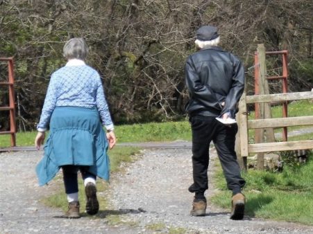
Along came the farmer who’d seen my approach, not to admonish me but to engage in good old honest chat. He had an interesting history and was full of information about the locality. Further up the trail as I walked inland he reappeared to take a picture for the JOGTrail Facebook page.

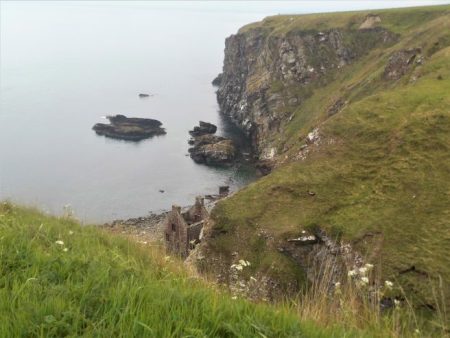
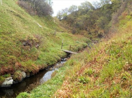
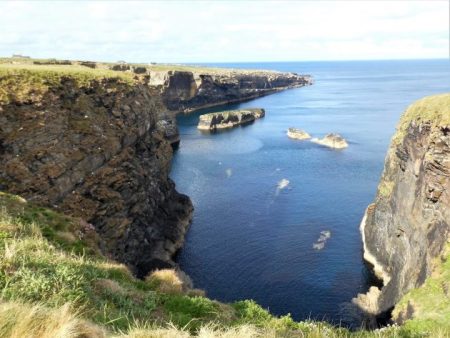
The next few hours were a delight on a mainly good path alongside the continually interesting coastline. Lots of large Geo’s to get round, sea stacks galore and the prolific bird life.

Ellen’s Geo.

Stack of Ulbster.

Sarclet Haven

Riera Geo

Riera Geo

At the massive Broad Geo I met a party coming southwards and found that their leader was no other than Jim, the new path warden, more conversation followed. This was a great spot for bird watching – I told you there was too much to see.

Mainly guillemots.

Razorbills

Broad Geo

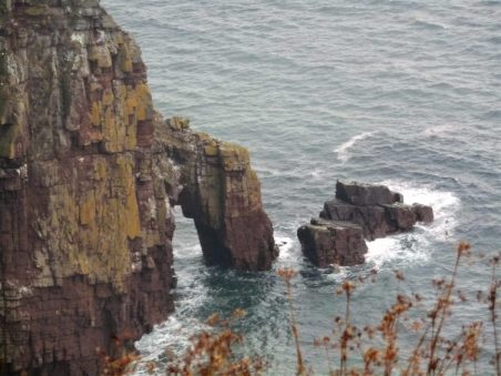
A little further on and along comes the highest sea arch in Britain, the Needle’s Eye at the head of Ashy Geo.Off shore are a couple of hundred new wind turbines, I could just make them out.

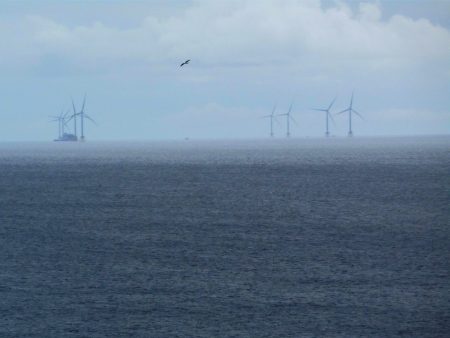
I became lost once or twice on the broader, lower fenced areas, beware of your best waterproof trousers on the barbed wire fences.

The cliffs now are much lower but still show a diversity of geo’s, stacks and caves.

By the time I arrrived at Old Wick Castle my enthusiasm was waning.  It is one of the oldest castles in Scotland, though originally built in the early 12th century by Norse kings who then ruled Caithness, it was well situated between defensive geos.

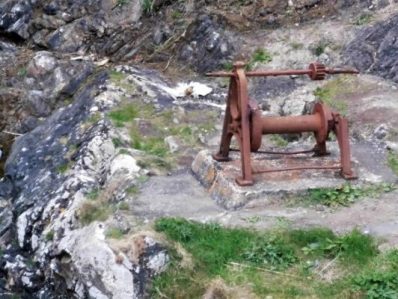
Minor roads through industrial areas, probably most connected to off-shore work. The harbour was busy, you can catch a boat to the Orkneys from here.

My simple b and b by the harbour had the steepest stairs up to the second floor, no pity on the weary.

Wick town centre was a little run down, but I managed to find a cheerful Italian for supper.

Accommodation – Harbour Guest House, 6 Rose Street.

*****

Out of interest here is the elevation profile for the day –

JOHN O’GROATS TRAIL – 11. Lybster to Whaligoe Steps.

Stacks of stacks.

For this section the guide keeps mentioning to look back at the views – so I often did. A reminder that if the sea is on the right in my photos I’m heading North, if on the left I’m looking South.

Halfway through breakfast my landlady was called away by a friend who’s car had broken down, leaving me to fend for myself. On her return we put the world to rights so I didn’t leave till after 10.30 with a gift of two hardboiled eggs in my pocket. I walked down that main street like John Wayne, everyone stayed indoors.

The first stile just out of the village seemed to have been appropriated from a swimming pool. After crossing a small burn I was on the cliffs using a tortuous path, more of a narrow sheep trod. I realised that keeping within the narrow line made me walk like a catwalk model. The day was just clearing and the views opening up.

In the first large geo [sea inlet] was an abandoned building presumably related to the herring trade of the 18/19 centuries. The first of several small harbours and geos which all involved a considerable inland detour and descent/ascent to cross streams.


A disturbing sight alongside the fence was a tip of some farmer’s rubbish, where does he think it will go?

Once round White Head a stream had to be crossed between pretty waterfalls.

Back on the cliff top the roller coaster ride continued with lots of stacks and arches along the way. One of the finest stacks had a stone cairn on its summit implying an ascent in the past. Everywhere were birds mainly fulmars, kitiwakes, razorbills, guillemots and shags.

The long abandoned Clyth Harbour was a delight.

Back on slightly lower cliffs the path was easier to follow towards a disused lighthouse and it was here I saw a pair of Orcas, actually I heard their blowing first and then watched them swimming away only surfacing occasionally. Along this stretch were several skerries, low rocks off the coast, The rock strata here is much more horizontal ideal for drying cormorants and a diving shag.

Past the lighthouse I found a lunchtime stone, enjoyed the sun and watched the birds flying by.

Line Geo was spectacular and the cliff edge path getting round it equally so. The cliff ledges are home to thousands of birds, the noise is deafening in some of the geos. Kittiwakes, razorbills and guillemots.

Halberry Head was my next objective.

The massive Stack of Mid Clyth. big enough to be called a dependancy, is in fact a giant sea arch.


Another hairy crossing of a large geo on a narrow track. More sea stacks and and caves followed. This is possibly the best days walking so far and I was enjoyingmyself. More was to come in the next mile with Long Gate Geo showing outstanding hidden depths.

After that I was lost in gorse bushes and dropped too low down the cliff slope. My first attempt of climbing back up through the inpenetrable gorse led to retreat and a further detour that left me scrambling up the very edge of the deep Red Geo. I thakfully came out close to the A99 road. The final few fields seemed awkward, one final geo and I was glad to see ahead my lodgings for tonight. The famous Whaligoe Steps Cafe, though it looked uninspiring from the outside. The weather was just closing in as I arrived, I can’t believe I’ve only walked 7 miles, a lot has happened.

I was made very welcome by John and Edna and their two Highland Terriers, an Aswam tea revived me sufficiently to go down the 300+ Whaligoe steps to the original herring harbour in the geo. It was a quiet low tide and all was tranquility. I sat and was able to watch some of the birds at close quarters.

Fulmar.

Shag

Razorbills

Climbing back up those steps I thought of the women carrying baskets of herrings to the store which is now the cafe.

I dined well on authentic Ramen noodles.

*****


JOHN O’GROATS TRAIL – 10. Dunbeath to Lybster.

Close to the edge.

Harbour to harbour.

I awoke early and looked out onto the camping site, the backpacking lady had broken camp and was well on the way, never to be seen again. The eclectic international selection of camping vans were asleep.

The sea mist was in as I left the B and B and wandered down to the little harbour.   In a shed there was a restored fishing craft used in these parts in the 18 – 19th centuries, the heyday of the herring fishing industry. Old pictures showed the harbours on this coast packed with these vessels. I can’t imagine going out to rough seas in one of these small boats.  Further along was an old ice house for storing the fish.

The day’s climbing began up onto the first headland, the cliffs along this stretch were rugged and varied with sea stacks and arches. The path was close, often too close, to the edge giving spectacular views down. The walking was easier than the last two days and I made good progress with time to stare.

Further along where the path moved into inland fields the guide suggested walking on the road to avoid cattle. I was only too pleased to conform as I don’t like meeting bulls. The A9 was surprisingly quiet and I walked on for maybe half a mile then realised I was cut off from the coastal path by a high deer fence which took some precarious manoevers to overcome. I crossed a field towards the coast passing perhaps some ancient stones only to find myself up against another deer fence.

My climbing technique had improved and I was soon back on route on a much gentler, lower cliff top still with lovely inlets and stacks. The weather was improving and the sun had burnt back the mist.

I was now approaching Latheronwheel harbour and a few more walkers were out. A track lead down and over a surprisingly sturdy bridge onto the road which climbed towards the village. I took off at a bend to regain the headland with more sea stacks.

The next stretch of cliffs were grassy and apparently home to puffins but perhaps they haven’t arrived yet. There was a lengthy diversion inland to get over the deep Burn of Latheron.

Back on the open cliff tops there was a strange stone structure, not marked on the map,  perhaps a beacon or lookout.  I had a rest and snack on Robbery Head taking in the views up the coast and watching the birdlife. Looking back at the cliffs there were some amazing foldings in the rocks. There’s certainly plenty to see on this walk.

Robbery Head.

The day was moving on and there were still more ups and downs ahead. The next down was over the Forse Burn and then up to a headland with the precarious looking remains of the medieval Forse Castle. It reminded me of that game where you remove a brick without it all falling down – Jenga.  Below was a beach with a ruined building, presumably related to the herring fishing.  I was tempted to drop down to investigate when I met a mother with two lads who were going down using a fixed rope, it all looked very exciting.

There was an even steeper drop into the Achsinegar valley. Down here just above the sea were the extensive and evocative ruins of a herring processing station from 1810.

Rough ground followed below Swiney Hill. I found a seat and fine viewpoint above Lybster bay. Then soon I was above Lybster harbour, the last of the day, as a little boat came in probably from visiting lobster pots.

The main street of Lybster is far wider than most towns, nobody seems to know why.

A shop next to my friendly b and b provided supper. I’ve just found my first tick despite being extra cautious.

Accommodation – Bolton House B & B  Main St Lybster

*****

JOHN O’GROATS TRAIL – 9. Berriedale to Dunbeath.

Misty clifftop walking – but lots to see.

The excellent weather of yesterday couldn’t last and I spent most of today in drizzle, not that it mattered much as I was looking below at the cliffs and all the birdlife.

Yesterday’s bus driver welcomed me aboard for the short trip back to Berriedale,I was the only one alighting.  I avoided the temptation of the cafe and made my way down to the harbour, I don’t think many boats tie up here.  A bouncy suspension bridge crosses over to a row of cottages above the rocky bay. Proper ornithologists have their telescopes trained on the conveniently placed cliffs, I spot kittiwakes through my pocket binoculars but fulmars are also pointed out to me. The waves are crashing into the shingle beach.

A green path heads up towards a small cemetery but there I become lost in earthworks for another straightening of the A9, as if it is not fast enough already. My frustration is tempered with good views back down to the harbour. A bit of bashing through gorse soon has me back on track but on the wrong side of a fence which can create a problem.

Once on the clifftop I kept mostly outside of fences and walls – this was proper cliff walking  – right on the edge. A good head for heights is useful in some places and I wouldn’t like to be here in a gale.

The Bluebells are late flowering up here and they give a colourful show with Pink Campions and Greater Stitchwort

In rough land there was someone’s private bird hide, I imagined the owners bragging at a cocktail party “oh we have our own private hide  – don’t you?”   It did have a fantastic view though.  A little further just entering some trees was a box containing a signing-in book for the trail, only about 25 had done so this year.

Ahead the headlands were all a bit vague in the murk but here was my first sea arch.

Through a high cliff the Allt na Buaidhe stream tumbles in a spectacular waterfall, it was a bit short of water today.

I worked my way round to the valley of the stream where there was a new footbridge to cross. Strangely a path had been strimmed to the very edge of the falls, a every dangerous spot, Samaritans help number needed, but good views back to that small sea arch. You would have to lie on your stomach to look over at the waterfall – I didn’t.

The path to nowhere…

Moving on I was getting ready for lunch and spotted a stone bench, this turned out to be the perfect viewpoint for watching the birds on the An Dun headland and it’s massive arch.

I dont think I’ve ever seen so many birds, literally thousands on every ledge available. Mainly Guillemots and Razorbills. The latter are distinctive closeup.

The Kittiwakes and Fulmars tended to stay aloof.

After all that excitement in the next bay was The Cleft sea stack, it remained in sight for some time.

The going became difficult in long rough grass with only faint sheep trods to follow. However a group of sheep startled by me proceeded ahead creating a path as they went – a good idea for helping open up the trail.

Another stack appeared as I traversed high above the sea.

Diversions inland around Dunbeath Castle weren’t too bad how does this fit with the so called Scottish right to roam?

The gates to Dunbeath Castle are not overly friendly to walkers, a lot of these estates have been bought by rich foreigners who would like to keep the likes of us off the land. I didn’t get the feeling that there was much opposition to this denial of the right  to walk wherever as allowed by Scottish law. Maybe time for a mass tresspass.

The old A9 entered the scattered community that is Dunbeath, everywhere was shut.

An old path goes down to the Dunbeath harbour from where there is have a steep climb to my B and B.

That felt like a long short day.

Accommodation – Inver Park House B & B

*****


JOHN O’GROATS TRAIL – 8. Helmsdale to Berriedale.

Baptism of fire.

As soon as I was on my way this morning the familiar sounds and smells of the coast came flooding back. I was glad to be here though this is supposed to be the most arduous day of the whole trail.

A gentle stroll along from the harbour, just above the beach, and then at a ruin a sudden dog leg climb towards Navidale, a few houses and a cemetery. For the rest of the day I was well above the sea but it was ever-present. The Ord of Caithness was prominent ahead, I am in Caithness for the rest of the trail.

The most notable detail throughout today’s walk was the gorse, I have never seen it so brightly coloured before and in places I became heady with its coconut fragrance.

Easy walking through rough fields was tempered by the lack of waymaking on this stretch. Apparently some landowners don’t want markings but you are still free to walk across their land in Scottish Law. There were a few small burns to cross and then indistinct trods climbed gorse slopes to meet a more distinct track heading back down again. You could easily get lost hereabouts. Somewhere along here a couple of WW2 lookout huts were passed and waymark posts appeared. The Ord burn was easily crossed and then height gained steeply into the moorland of Ord of Caithness. Fairly random trails across damp moorland were followed almost to the A9 road and yet I felt a long way from civilisation.

The sounds of the sea were still prominent despite being well above it. Below was the green table, a flat promontory and site of an ancient fort. A secluded bay to its north gave an idea of the birdlife to come.

The green table.

Shags or comorants?

The ground became boggier but as there has been little rain in the last two weeks it was pleasant to walk on rather than troublesome.  A burn was followed gently downhill past ruined buildings from the 19th century and a recognisable broch from the iron age with its chambered entrances.

Over the next steep stile the ground dropped away alarmingly into the deep ravine of Ousdale Burn. Attempts are in progress at building wooden steps but for now I was grateful for the trees I could swing off [opening photo]. Eventually down the burn was no problem as a bridge has been recently erected, there is a surprisingly large amount of new infrastructure appearing. I must make a donation to the charity responsible, I suspect a lot is a labour of love.

Of course it was steep up the other side of the ravine.

One came closer to the sea and seabirds were flying everywhere whereas before it was mainly smaller birds amongst the gorse.

Sheep trods weaved over the headland between the gorse bushes, a tough section. Then there were the ruined buildings of Badbea and there in front was the monument to honour the tough families forced off the land in exchange for more profitable sheep. Life at Badbea would have been harsh, many residents emigrated in search of a better life and the memorial commemorates many of them. A good spot for some lunch. Having seen nobody all day suddenly people started appearing from nowhere, well actually the close-by A9, all attracted by the ‘clearance village’ signs.

Through the gorse there was much bird song and I managed to capture a photo of a Brambling on the monument itself.

Easy walking on heathery tracks continued over the headlands, if not quite on the edge of the cliffs close enough to hear and see more seabirds. Inland were the Caithness hills with the conical peak of Morven, at 706m the highest, in the background.

Two towers, navigational aids from the 19th Century were useful markers today. They were aligned for approaching Berriedale harbour and used to carry lights, the Duke of Portland’s Candlesticks.

More headlands appeared ahead but I’d done enough for today. The harbour of Berriedale was below and dropping down to the A9 I headed for the renowned River Bothy tearooms for tea and cake whilst waiting for a bus to take me to my B and B in the scattered village of Dunbeath.

Its been a long day and fortunately I didn’t go far astray in sometimes difficult terrain. A good start to my week and not as arduous as I was expecting mainly because the bracken has only just unfurled, wait till it’s head high.

Accommodation – Inver Park House B & B

*****


JOHN O’GROATS TRAIL. [Episode 2] Helmsdale to John O’Groats – a continuation.

Stacks of Duncansby, copyright Ken Crossan

Last summer I had a week walking up the coast from Inverness to Helmsdale on what is to be the John O’Groats Trail.   http://www.jogt.org.uk/

This was the penulitmate section of my 50 odd years linking Lands End to John O’Goats on foot.

I realised the trail was in the process of being developed by a gang of volunteers and I had little information. Most of the time I was able to walk at my will on beaches and minor roads in the general south to north direction. Occasionally I came across white  waymarks and stiles showing the proposed route.

This year I’ve been able to glean more information and have a download of the draft guide book as well as an optimistic Harveys Map of the route.

For this next part of the trail there are warnings of difficult walking over rough pathless ground, awkward or non existent stiles [take thick gardening gloves to negotiate the barbed wire], ticks and cattle, high summer vegetation [carry a sickle],dangerous river crossings  but also dramatic cliff tops, sea arches and stacks, abundant bird life, historic harbours and welcoming villages.

Can’t wait to get started.

I’ve a train ticket to Helmsdale, a 10hr journey, where I’m booked into the friendly Belgrave Arms. The forecast is good . It’s time to complete the trail.

There was some excitement at Perth where it was lassies day at the races.

As I passed through the highlands I couldn’t help but notice how what had been pony tracks were now harsh landrover highways. On reflection it must be 20 years since I’ve climbed a Munro.

After Inverness the train followed part of the coast I walked last year and I even spotted a backpacker heading north . I’m now waiting for my meal in the hotel with gorgeous evening light across the bay. I can’t help but notice the gorse covered hills looming up above the coast – tomorrow morning’s start.

Helmsdale across the bay from the train.  Dirty window.

The hills above Helmsdale.

Helmsdale harbour

For reference in my subsequent posts if the sea is on the right in photos I’m heading north if it’s on the left I’m looking back.


*****


A SUNDAY MORNING STROLL.

I can’t say much new about Longridge Fell.

Over coffee I was plotting a route from Brock Bottoms when the phone rang. it was Dave asking if I fancied a walk on Longridge Fell. I couldn’t say no. I’ll put the river walk on hold.

I’ve not seen much of Dave since my PMR episode put rock climbing on hold, and anyway he is abroad most of the time. A quick turn around and we met up at Cardwell House car park at 10am.  He was not familiar with this western end of the fell so I had hoped to give him a good tour. We caught up on our recent relevant excursions. He has just had a successful three week’s climbing trip to the south of France, I’ve mainly been at the doctors. As I waited at the car park I tried out the panoramic mode on my camera with the Bowland Fells over Chipping Vale.

He seemed to be enjoying the route I took trough the forest until we hit an area of tree felling across the track, the next 200m was tedious to say the least. He likened it to anti tank defence terrain from the 2nd WW.

We eventually emerged onto a familiar track up towards the summit but a blocked path forced us onto another rough section.

The views from the trigpoint were exceptional but we didn’t linger as we had already taken much longer than anticipated.

The way back to the car traversed the fell overlooking the Vale of Chipping again on a track he had never used.

It was good to catch up.

*****

The weather was so good that I decamped to Craig Y Longridge on the way home for a bit of bouldering and more catching up with friends who were there, it was busy.Just across the road on a small reservoir a pair of great crested grebes have set up home in reeds within sight of the road. The female is sitting on three eggs so far and the male fussing around extending the nest.

DUNSOP VALLEY AND BURN FELL, ANOTHER BOWLAND TOP.

Burn Fell seen on the approach along the Hodder Valley to Dunsop Bridge.

On the 2nd of January 1945, just before I was born, a Consolidated B-24 Liberator, an American heavy bomber crashed on Burn Fell. The aircraft was being ferried from Seething in Norfolk to Warton near Preston, most of the passengers were a second aircrew who were going to fly another aircraft back to Seething. The crew had become disorientated in low cloud and snow showers, they obtained a radio fix on Warton and the pilot turned onto the appropriate heading to get to Warton and while flying at just 1500ft the aircraft flew into the top of Burn Fell, slewed round demolishing a stone wall and bursting into flames. Most of the aircraft was reduced to ashes, fortunately of the 19 aircrew onboard 15 of them survived the crash and subsequent fire. People from farms below the crash site came to rescue the survivors from the snowy hillside with makeshift stretchers and human strength.

I  passed the site of this disaster on today’s walk in Bowland.

A bright sunny morning, and I was parked up in Dunsop Bridge before most people had stirred. The walk up into the Dunsop Valley is familiar and the water board road gives access to both the Brennand and Whitendale valleys, with the hill of Middle Knoll [not to be confused with nearby Mellor Knoll] between them. Where the roads split there is a small footbridge across the river which takes you onto a track up into Whitendale above the water.

Middle Knoll.

At Costy Clough the track gives way to a narrow path, This is delightful walking with the hills beckoning ahead whilst the water tumbles below. The farm at Whitendale comes into view, part of the royal Duchy Estate. By now I was in fairly remote hill country and using trods through the heather, A sign post erected by the Peak and Northern Footpaths Society showed my options just above Whitendale Farm. I’ve never quite known who they are. From this area I had a view to the southern face of Middle Knoll and was surprised to see how steep and rocky it looked. The lambs around here looked almost newborn, very unsteady on their legs. A zig zagging track started to climb out of the valley onto Dunsop Fell, mainly to visit some shooting butts, but it gave me an easy way up to the watershed especially as the peat was less squelchy than usual. Suddenly there were people ahead of me, I caught them up at the top as they took in the views. A family group from Wigan who seemed to know the area well. Oh, and here is another one of those signs. Where the three went down I contoured and found a path of sorts leading to the trig point on Burn Fell, 431 m. Over to the east were the Three Peaks, Yorkshire’s finest. Below was Stocks Reservoir, Waddington Fell with its mast and behind that the big end of Pendle. I followed the wall past the trig with Totridge Fell ahead and the Hodder Valley stretching out towards Longridge Fell, these Bowland Fells group themselves closely together, I could clearly see the line of my Longridge Skyline Walk coming off Totridge Fell, over Mellor Knoll down to the Hodder, over Birkett Fell to Waddington Fell before dropping to recross the Hodder and finish over Longridge Fell.

Over to Yorkshire with Stocks Reservoir.

A few 100 m past the summit I came across the remains of the B-24, bits of molten metal and glass. A cross has been erected and there is a stone memorial to the four airmen who lost their lives.

A track of sorts through the boggy heather slowly brought me off the fell and down a grassy rake towards Beatrix Farm. It was here that I started to encounter boxes/tunnels designed to trap stoats etc. as I neared pheasant breading copses. Inside each box was a strong spring-loaded trap. I’m not sure of the legality of these traps as any prey would suffer a horrible death. The remains of a ?rabbit in one showed that they are not regularly checked. It was surprisingly how vicious they were when a stone was accidentally dropped onto a trap.

A lane down into Dunsop Bridge gave easy walking after the rough stuff on the fells. Bluebell woods welcomed me into the hamlet at the centre of the Isles. Cups of tea at the café beckoned before my drive home. Today I had seen or heard wagtails, skylarks, oyster catchers, cuckoos, curlews, buzzards and whilst getting into the car a dipper on the stream below.*****


WHIN FELL – ANOTHER BOWLAND CIRCUIT.

Sorry about the photos.

Set off today after lunch and parked at Smelt Mill in the Trough of Bowland, this is the headquarters of the Bowland Pennine Mountain Rescue  team.

Smelt Mill with Mellor Knoll behind.

On the 1:25,000 map I noticed a track leaving the road and zigzagging up  Staple Oak Fell. I found it and was able to follow it through rough ground to a fence just below the 415m summit. I hopped across the fence and went to the highest point, I’m not sure why. It was all much of a sameness. Views kept opening up in all directions and I took loads of photos of the surrounding Bowland Fells. I then simply followed the fence to meet up with the bridleway from the Trough over to Brennand. In the past this was a regular mountain bike route for me taking the thrill a minute ride down Ouster Rake to the Duchy’s farm deep in the Brennand valley. I couldn’t resist a slight diversion today to view that descent, it did look dramatic.

Returning to the col I decided to follow another fence up to the trig point of Whins Brow 478m on Whin Fell. There were some boggy peat haggs to negotiate before the summit. Views to Morecambe Bay, the three Yorkshire Peaks, Pendle, Longridge Fell and the nearer Bowland Fells above Hareden and Langden Valley where I was tramping a few days ago. Splendid.

The Trough of Bowland with Totridge Fell prominent.

I took a beeline off the summit down steep grassy slopes into Rams Clough to meet up with that bridleway coming down from Whin Fell. A winding lane followed the valley down to the Trough Road near a barn. As I walked down the road I recognised a gate leading to the Trough of Bowland Quarry, an esoteric climbing venue I’d not visited for 20 years. The cliff looked remarkably clean and very steep. I recognised some of the lines taking ramps across the face to an unfortunate loose top. I even spied an old peg! I wondered if it was still in the Lancashire Climbing guidebook, yes it is though I doubt many people climb here anymore shame really as it has a lovely situation for a summer’s evening in peace and solitude. It was whilst I was in the quarry that my camera started flashing “memory card damaged” – how could it be. But no it refused to take any more photos and more annoyingly will not download any of today’s pictures.  This cheap camera, a Praktica L212, has always had a problem with the memory card losing the occasional pictures. Wilkinson’s Cameras, Preston, have failed to resolve the problem and I will be down there tomorrow with the latest complaint. Annoyed at loosing some fantastic views today. Took some pics with my phone but even those are poor, not my day.

Trough of Bowland Quarry…

…and nearby lime kiln.

Wandered down the road past Sykes Farm and then the Langden parking spot as the tea van was packing up. Soon back at Smelt Mill.

Sykes Farm.

Trough tea van.                                                                                                                  

PS. The memory card was unreadable but Wilkinson’s gave me a replacement free despite well out of guarantee. Local shop 1 Internet 0.

So my camera back in action but those photos lost forever – a good excuse to repeat what was an outstanding walk.

*****

CICERONE’S LANCASHIRE – LANGDEN AND HAREDEN.

I was so inspired by my last walk in the Bowland Area that I started looking for more  routes around Dunsop Bridge, I soon had several loops that looked promising. Time to try one I haven’t done for years, I enrol JD for some exercise. Simply this is up the Langden Valley, then Bleadale, over a bit of a hill and down Hareden Valley. It happens to be walk 6 in the upcoming Walking In Lancashire guide by Mark Sutcliffe, although I didn’t know it at the time.

The morning was dull and drizzly but promised to improve as we parked up on the Trough road at noon, not a soul about. A relaxing stroll up the valley  gave me a chance to catch up with JD’s recent exploits in various parts of the country – Lakes, Wales and Malham.

We disturbed a pair of Greylag Geese with their clutch of youngsters. There seemed to be plenty of Pheasants about but not much else.

Spot the chick.

On the map two ‘castles’ are marked; Holdron Castle which turns out to be a rocky outcrop and Langden Castle which is a shooting hut. We made for the latter for a place to sit for a bite to eat. The outer ends of the hut are open but despoiled by sheep and humans, the central room is now locked and shuttered although in the past I have bivied in it when my children were young, I remember getting a roaring fire going in the hearth.

The path continues up by Langden Brook into Fiendsdale and over a boggy col to Bleasdale, but today we turn south to enter Bleadale, confused?  The stream crossings here can be hazardous but to-day with all the dry weather we hopped across with ease.

The path up into Bleadale is squeezed in by the stream with a little scrambling in parts but is better than I remember it.

Again this valley could be followed all the way over Saddle Fell and down into Chipping, but we strike off again to climb Zig Zags in a subsidiary clough leading over Hareden Fell.

Higher a path of sorts is found between the peat hags helped by some marker posts near grouse butts, these fells are shooting territory and the estates have come in for some criticism lately for illegal raptor prosecution. We don’t see any birds of prey all day whereas in the past Peregrines, Merlins and Hen harriers were fairly common. [Later in the day we meet a couple of RSPB wardens on patrol, so there must be nesting raptors about.] This is a remote desolate place, and we are glad of the good visibility.

We meet up with the estate Land Rover track leading down into Hareden. Below us to the right is a very steep-sided valley of Hareden Brook and the lower wooded parts are the home to Ring Ousel, I suspect I spotted a female but couldn’t be sure as it flew swiftly past.

We wander down and enjoy a rest by the river just before it enters water treatment plants. The worker’s cottage and garden is obviously well looked after, all is neat and tidy. The bird boxes in the shelter belt of trees are all marked BASC, ironically The British Association for Shooting and Conservation who are generally more focused on shooting.

We passed the houses at Hareden Farm as I had done a couple of days ago, the dogs were still barking. Just after the farms a concessionary path follows the Langden Brook back upstream avoiding the road giving a fitting end to our day of linking brooks. I’m already planning my next Bowland circuit.

*****

MELLOR KNOLL AND THE HODDER.

Totridge Fell and Mellor Knoll from Burholme Bridge at the start of the walk.

Mellor Knoll is a 344m lump in Bowland, I didn’t actually climb it but I came close.

I was in my dormouse mode this morning and stayed in bed with my second coffee looking at maps whilst the day warmed up. Eventually, I stirred and drove out to park at Burholme Bridge on the River Hodder. Early morning cyclists were already returning from their Trough of Bowland circuit, a popular ride with Lancashire cyclists: one of the most prominent I met later in the day. I last cycled it 5 years ago.

A quiet lane leads up into the limestone area of Bowland with its Reef Knolls and caves.  A footpath brought me onto the farm track to Whitmore, a lonely farm at the base of Totridge Fell. In the past there were free-range hens wandering about although today the scattered wooden hen-houses looked deserted.


Welcoming committee.

A bridleway takes off towards the woods on a track that was always muddy but tree felling has opened up the landscape and things are improved. This bridleway cuts through between the cone of Mellor Knoll and the parent fell of Totridge. Contouring the hillside was a joy with bluebells and fresh green beech leaves; views down to the snaking Hodder and the little known Birkett Fell, Waddington Fell and distant Pendle; towering above me was Totridge Fell with stone walls going straight up the steep slopes.

With all this excitement I wandered off course at the col and was heading the wrong way into Hareden Valley, it wouldn’t have mattered on this open ground but I traversed back to the correct track. Up here the hardy sheep only seem to have one lamb as opposed to their lowland softies with twins and triplets. Oh and this is how to mend a wall…

I was now looking down on the farms of Hareden with the Trough of Bowland in the background. The hounds at the farm always give you a greeting long before you arrive.

Crossing Hareden Brook [dippers were seen] and then Langden Brook brought me onto a short stretch of The Trough of Bowland road.

Looking up the ‘Trough’ road.

I followed this for a short way before I could continue across fields to the water board road following the River Dunsop past cottages to the hamlet.

I’m sure these weren’t designed for outdoor seating.

Mellor Knoll above the new houses in Dunsop Bridge.

This is a popular walking area and lots of families were out enjoying the sunny weather and the delights of Dunsop Bridge hamlet – often cited as the geographic centre of Great Britain, although different measurements give different results. I passed the BT phone box which celebrates this fact.

A line of tall pines leads to Thornyholme Hall and farm over a bridge on the Hodder. The last time I passed here in 2013 a chain saw artist was just beginning rendering a stump into a statue of the thinking man and the results were seen today.


There is a lovely stretch along the River Hodder, ducks and their ducklings were swimming by the bridge and further on I watched sand martins going back and forth to their holes in a sandbank. If you click and enlarge the photo I actually caught some of them in flight and at the nest entrances. It was on this stretch I met an elderly couple walking towards me on a short river ramble, somehow the conversation turned to cycling and it transpired that the 80yr old gent was Dave Brown. He had been a prominent racing cyclist with impressive time trial results over all distances, only retiring after he had passed 70yrs. https://www.lancashiretelegraph.co.uk/sport/3829912.east-lancashire-cyclist-retires-after-53-years/  He told me he had written a weekly cycling column in the Lancashire Telegraph for 40 years until they recently decided to scrap it!  We swapped tales of cycling in the past, what a lovely chance encounter.

Soon I was back at Burholme Bridge having completed an interesting, if modest, 7 mile circuit feeling privileged to be living within this beautiful Bowland area.


*****