Monthly Archives: September 2020

THE HODDER FROM DUNSOP BRIDGE – NEW PATHWAYS.

JD and I make the best of this lovely late September weather on another section of Lancashire’s loveliest river. We find paths under the Bowland Hills that neither of us have traversed.

We leave a quiet Dunsop Bridge at 10am and walk the familiar track lined with giant redwoods  to Thorneyholme Hall and then head upstream through fields next to the Hodder. The grass is wet hinting that the cold nights of Autumn have arrived. A fisherman appears and instantly recognises JD from their mutual BAE Systems workplace. Pleasantries are passed, and we wish him success at catching a trout.

Across the river we spy the Sugar Loaf hill, a limestone knoll which has been quarried for the kiln below. It is said that at one time a gibbet stood on its summit. I keep meaning to go and have a closer look.

Further up the river we cross a wire suspension bridge which bounces alarmingly. When and why was it built?

The road is reached at Boarsden Farm, and we walk along it for 1/4 mile leaving the river, there is no traffic. A footpath cuts up the fields past the largely unseen Heaning Farm. Some soggy fields later we pop out onto a tarmacked road only to acutely turn back into fields leading to Gamble Hole Farm. Just above it is a large hole formed when a cave system collapsed. We are in limestone country and there are several sinkholes in the next large field. There is also a bull with his cattle, so we keep the other side of barbed wire and exit eventually into the aptly named Bull Lane. Lunch is taken in the warm sunshine and I decide to alter our route. Over the wall I’ve spotted a series of paths along the base of Burn Fell, so we backtrack a little to walk up a minor road before heading to Burn House Farm and its barking dogs. This farm is at the back of beyond with amazing views to Pen y Ghent, the Easington/Waddington fells and all the familiar Bowland fells surrounding the Trough road.

Farms under Burn Fell.

Wide views.

Our track contours the base of Burn Fell and there is a memorial to several WW2 aircraft crashes in the vicinity. I visited one on Burn Fell last year.

A delightful interlude takes us into trees and a hidden clough. Eventually we arrive at Beatrix Farm which was on my original route. This has been a stock rearing centre since the C13th and was once a busy hamlet with its own market. There are traces of grassed-over foundations of long vanished dwellings but I’m not sure we recognise any. Ahead Totridge Fell and Mellor Knoll increasingly dominate  the scene.  Bowland at its best. Chatting away we soon reach Wood End Farm with its diversified herds and then Dunsop Bridge. There is not enough social distancing available in the café for tea and cake.

An excellent round on paths new to us alongside the Hodder and some remoter farms of Bowland.

*****

NEWTON AND SLAIDBURN.

                                                     The Hodder between Newton and Slaidburn.

A short walk was all I needed today.

I’m always driving through these two villages, so I thought it was time to visit in more detail. During this Covid-19 pandemic everyone seems to be out and about. All the car-parks are overflowing and the honey spots overwhelmed, I’ve usually kept well clear but today I had to park up in Newton. Mea culpa.  I found a safe spot outside the village but noticed some thoughtless blocking of farmers’ gates etc.

I first wandered around the olde worlde hamlet of Newton – in – Bowland.

Georgian Newton Hall.

Salisbury Hall.

John Brabbins Old School. 1757.

Old school 1842.

Old reading room. Late C18th.

United Reformed Church. 1887.


Then I was ready to start the riverside walk to Slaidburn. The River Hodder.

Ahead was the limestone bluff above Dunhow Hall.

There are cliff faces up there in the trees and I had time to climb up and explore. On closer acquaintance the rock was overhanging and compact, not much scope for my style of climbing, i.e.  too hard. Whilst I was up here I explored further and came out into meadows on top of the hill with good views towards Slaidburn. I wandered down to re-join the path near the gatehouse and then walked into Slaidburn on a short stretch of busy road. The 15th century St. Andrew’s Church turned out to be open, I had never visited it but read of rich internal features. Most of the interior was taped off, so I only had a glimpse of the elaborate screen, Norman font, box pews and pulpit. Outside there was a sundial from 1796 and a shaft of a Medieval Cross.

Next door was the Old Grammar School founded in 1717 and still in use as a village school.

Rows of 16/17 C cottages lead into the village and there in front of you is The Hark to Bounty pub.

The inn’s name is from the sound of the C19th Squire’s dog, Bounty.

At the top of the steps was the old courtroom of the district. On the outside of the iron rail the lower steps  were used for horse mounting.

The war memorial is on an island and an old Wesleyan Chapel has been restored.

Chapel Street.

The café on the village green was doing a roaring trade from passing travellers. Some impressive motorbikes were on display.

Leaving the hubbub I climbed away from the bridge and crossed into fields heading over into the Easington valley I’d been in a few days ago. The weather conditions today were much pleasanter with clear views of Easington Fell.

At Broadhead Farm I chatted to the farmer as he selected lambs to go to auction.

Following Easington Brook…… I came to the impressive Easington Manor House once again. Easington hamlet was as quiet as normal. Onwards through fields by Easington Brook to join the Hodder and a path back to the elegant Newton Bridge. And that was just a short walk.

*****

LONGRIDGE FELL AGAIN.

As I had been out walking most days last week today, Saturday, I had intended to go bouldering up on the fell.

The sun was shining through my curtains early this morning promising a fine day. I was sipping my life giving coffee when the phone rang suggesting a short walk on Longridge Fell. As I have not seen Dave and Christine for a while, we are in special measures in Lancashire with no visiting house or garden. I’m glad to meet up with them. As I thought the parking would be busy.

We strolled up the fell chatting away. We remarked on how fast the fir saplings were growing and intruding into the path. What will it be like in another few years?There was a cold wind blowing and it felt definitely Autumnal. Considering the number of cars parked up we saw few people, they may all have gone up to the trig point which we avoided.

A pleasant short walk in good company. I went bouldering up at Craig y Longridge in the afternoon.

*****

THE ‘SAFE SIX’ CLIMB NICKY NOOK.

My last trip to Nicky Nook was in February just before Storm Ciara and, without realising it, before the more devasting storm Covid.

I grew up with Enid Blyton – The Famous Five and the even better Secret Seven. Maybe my sense of adventure was instilled into my developing psyche from these innocent tales.  I’ll not spoil this post with any historical racial or sexual criticism of her works.

Anyhow today there were six of us  – the  safe six of these Covid times.

From http://www.gov.uk     When meeting friends and family you do not live with (or have formed a support bubble with) you must not meet in a group of more than 6, indoors or outdoors. This is against the law and the police will have the powers to enforce these legal limits, including to issue fines (fixed penalty notices) of £200, doubling for further breaches up to a maximum of £6,400.

We met up at a secluded carpark down single track lanes.  The other five had travelled from South Manchester and Cheshire and had invited me along for no particular reason, the only link being blog posts we mutually follow.

Introductions completed we set off suitably distanced.

Everyone took photos of this unusual School Bus Stop. I don’t know which school or which bus but there can’t be many pupils.I didn’t pay much attention as to which way we went but we passed through several typical Lancashire farms and I have to admit the waymarking was on the whole excellent. With our intrepid leader, follow the orange cap – phreerunner in another guise, striding out confidently we were soon onto the fell road skirting the wild Bowland Fells. We then dropped back into farming country and a lane where we came across a Wyresdale shooting party, ‘ducks and partridges’ season apparently. I met up with an acquaintance from Longridge who takes his dogs along for retreaving. they were heading off for lunch at the hall. No invites for us but there was a bench for a coffee break. My new friends excelled at this point by bringing out some homemade delicacies, Paul’s Fridge Cake was my favourite but Martin’s Chocolate Thingy was a close second. [My regular walking partners please take note – I expect better in future.]

Shooting party.

Coffee bench. In memory of a beekeeper.

A steady climb past a false summit and we were at the trig point, repainted since I was last here but sadly graffitied by the ‘was here’ brigade. Despite the biting wind we enjoyed views in all directions. Someone spotted the Isle of Man, someone else Blackpool tower and even North Wales. My pictures fail to show them well.

Leaving the crowds and doubling back on ourselves we took the steepish, but not the steepest, path through invasive rhododendrons into the delightful Grize Dale valley. Everyone was impressed by the path alongside first the reservoir and then the bubbling stream.

Another rememberance bench on cue signalled the lunch stop. I had to pass on the offered goodies.Fields took us into Scorton passing by the parish church whose spire is a well known M6 landmark.  Before long we were back at the carpark. An enjoyable stroll in Lancashire’s finest. I didn’t take as many photos as usual as I was too busy chatting but you can see more in Martin’s post and also read the true story.

*****

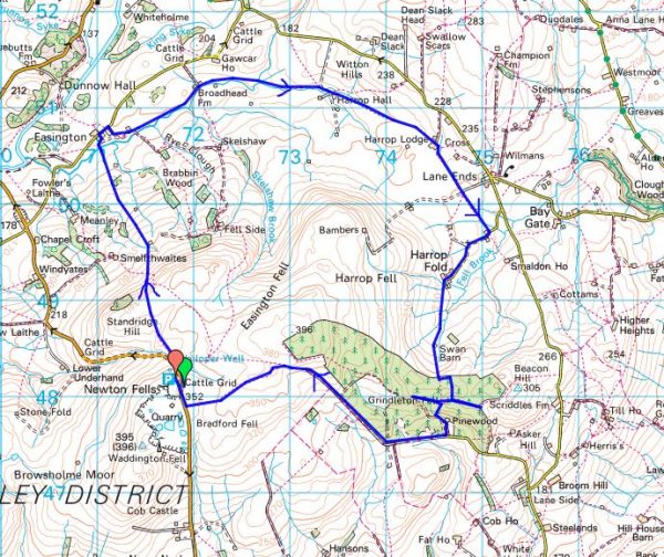
EASINGTON AND HARROP.

                                                                             Misty Easington Fell.

Two places hidden away in Bowland. I’ve driven through Easington but don’t remember end of the road Harrop Fold.

I planned to include Easington Fell into the round so I parked up at the top of the Waddington Fell road. I was the only car there on a misty morning and I hoped visibility would improve – it didn’t.

By the road side up here is Walloper Well.    Jessica Lofthouse (1976) described the place.

In the days of horse and pedestrian traffic none passed Walloper Well without stopping  to ‘quaff the clear crystal.’  Long ago, hill men, hunters, forest wardens and farmers off to Clitheroe markets and fairs, pedlars, lead miners from the nearby workings, all met here.  The name is thought-provoking. Why Walloper? From a word meaning a ‘fresh bubbling spring’, which this is, fresh from the moorside into stone troughs.  Age, wartime army practice and vandalism of 1974 made renewal of the trough necessary, but the flow has been constant.  One must drink, just as one throws pennies into the Roman fountain, to ensure one comes back again.”

So nothing to do with the frequently told story [very nonPC]  about the old man and his wife

Today there is no flowing water, I don’t know if this is the permanent situation.

After that disappointment I set off across the fell and immediately lost the path, if there ever was one. The ground was rough, what I call reedy walking, and you never knew if your feet would hit land or water.

Haircap Moss.

Persistence paid off and I spotted a cairn from where vague trods aimed to the barn shown on the map. From the hillside I could just make out Newton-in-Bowland, Easington and Dunnow Hall.

I was now on pleasant grasslands though this meant a herd of cows with accompanying bull. I was rather circumspect as was he. A teacher has just been killed near Richmond by cows.

Anyhow I arrived in to Easington unscathed and had time to look at the four dwellings making up the hamlet. The most interesting appeared to be the Manor House.

The Manor House.

I now followed the diminutive Easington Brook for a mile or so passing Broadhead Farm to Harrop Hall. On my approach to the latter the farmer shooed his herd of cows plus a large bull across the field for me to pass, a service I don’t normally receive. I realised at the remote Hall that I had visited before with a friend from Grindleton maybe 40 years ago to collect two kittens, Bonnie and Barnie I subsequently christened them. They were an adventurous pair climbing in through upper windows of my house and even venturing to the pub on the corner where customers fed them and returned them at closing time.

Harrop Hall.

Harrop Lodge was next, another building with interesting features including a Venetian window in the gable end and other bits of architecture.

Barn window.

Wall niche.

This stone footbridge took me into the wrong field from which it was difficult to extricate myself.At Harrop Gate I came out onto a little road through an isolated metal kissing gate.

200 yards up this road was Harrop Chapel with benches outside for my lunch stop. The chapel was built in the early 1820’s and has been in continual use since. It ceased to be Methodist in 1969 and now holds Evangelical services.

Refreshed I strolled up the road to the hamlet of Harrop Fold, only half a dozen neat dwellings. Of particular note is a large white house , an original C17th Lancashire Longhouse which provided accommodation for the family at one end and the livestock at the other. On the other side is the Manor House of a similar age.

So far the walking had been very rural but now I headed back up the fell past a barn and into Grindleton Fell Forest where my troubles started. The paths didn’t go where I thought they should and didn’t correspond to my map.  The trees limited visibility and the mist descended. I walked in many directions without finding my intended onward route. I was glad to hit upon a track heading out of the forest to join a lane prominent on the map. It was now easy to follow across the fell until I came out onto open moor once more. Up here the views back down to the Ribble Valley must be stunning on a clear day. Ahead of me was the vague outline of Waddington Fell with its mast acting as a beacon to aim for. By now it was cold and damp and I was glad to reach my car. I’d clocked up 10 miles.

Not many of you will have explored Harrop – ‘the valley of the hare’

*****

LITTLE BOWLAND VARIATIONS.

Little Bowland is the area west of the Hodder River below the Totridge fells. Limestone predominates giving springy turf to walk on. There is one minor road through the centre.

I often walk in this area but today, a hot sunny Sunday, I find some new paths and ascend a little hill previously missed. What follows is a rather dull description of this beautiful area.

I park near the entrance to Leagram Hall and walk up the lane through the park. As usual there are hundreds of sheep at Laund Farm, supposedly Blue Faced Leicesters. I take a track off to the right going over a hill to cross Leagram Brook at ParkGate farm where there has been a minor path diversion. Over more hills and down to Park Style which was being renovated last time I passed, there has been some progress but it looks unloved and deserted. So onwards to pass the buildings of Lickhurst and over a limestone knoll to Dinkling Green, another cluster of houses. Don’t they have some nice names around here. I usually continue further into limestone country from here but today walk down their farm lane until a sunken track takes me over a little col and down to that minor road I mentioned. I become distracted here by some crags just off the road. On closer inspection they are low and broken but there are some fine Maidenhair spleenwort ferns growing out of cracks.

Down the lane is a quarried reef knoll where there is some hard bouldering.

On reaching it I decide to climb the hill behind as there are no intervening walls as far as I can see. New Laund Hill a modest 229m. though what a fantastic view point it turns out to be. North up the Hodder towards the Trough Of Bowland and its surrounding fells, distant Pen-Y-Ghent, Waddington Fell and then down the Hodder to Longridge Fell and Chipping Vale.

By coming up this way I miss New Laund Farm and Fairy Hole caves. Through the interesting buildings of  Fair Oak, a barn has a date stone 1729, and on to Higher Greystoneley, my friends are out so I miss out on a brew.

I hardly recognised the next bridleway as most of the trees seem to have been cut down since the last time I was here.

There is another limestone quarry behind the prominent limekiln. I have a poke about and find some interesting faces which could be worth exploration.

I always have difficulty over the last stretch, there is a crucial bridge over Leagram Brook and I struggle to find it. I admire the mature trees in the park… … and contemplate the symmetry of Pendle and Longridge Fells.

I have only seen two people all day.

*****

NATIONAL ALZHEIMER’S DAY. September 21st. Finding a new path.


Over the last year I’ve been trying to find the right path to communicate with my lovely friend suffering from Alzheimers. While I could, I took her out to hopefully familiar places and friends. When her watch showed noon it was time to find somewhere to eat. Lager and lime, fish no batter, chips and mushy peas, was the order of the day.

Then we would play patience, she rarely missed a trick.

Then we would sit and do jigsaws, she had a quick eye for the right piece.

Then I would play music; The Beatles, Hot Chocolate and Niel Diamond. Was that the best choice?  A wave of the hands or a nod of the head meant a lot.

Then I would just talk about anything. A thumbs up was all I needed.

Then she stared, did she know me? Was that a tear?

Then she went.

***

After the funeral I went for a walk up Longridge Fell. It was a beautiful late Summer’s evening. I thought I had found a new path through the trees, maybe a gift to remember her by,  but it went nowhere.

It is National Alzheimer’s Day today, September 21st.

https://www.alzheimers.org.uk/get-involved/world-alzheimers-month

Have you thought of giving to their charity?


CLAUGHTON BRICKS, CATON FELL, THE PLAGUE AND THE LUNE.

I have lost my camera with this day’s photos on. When I say lost I mean I can’t find it but I’m certain it’s in the car or the house. After much searching it still hasn’t turned up. My mind’s not focused as it is the funeral of my best friend.

Yes, it has turned up under the carseat!

The day itself, a week ago, was brilliant.

As you drive through Claughton on the Kirkby Lonsdale road an aerial ropeway crosses above you carrying clay in buckets down from high on Caton Fell to the brickworks by the road. I’ve always been curious as to what’s at the top of the ropeway. The other end of the rainbow. Today I intended to find out and dragged Sir Hugh along for company.

We parked at The Fenwick Arms, sadly closed as a result of lockdown and other financial pressures. One of the many casualties.

A steady 1000 ft. ascent on a previously cobbled track with not much to see, Claughton Hall was hidden behind trees and Claughton Beck could be heard but not seen. Near the top we walked under the upper part of the ropeway. The buckets were trundling up and down by gravity feed. Constructed in 1924, this is the last gravity feed aerial ropeway operating in Britain. We crept into the upper quarry to see where the buckets were coming from – the answer was a shed where presumably the shale and  clay was loaded. There was a large quarry behind. We need not have trespassed as there are plenty of YouTube videos.

We came out onto the open moor near the wind farm and past the restored Moorcock Hall – certainly one of the remotest houses in Lancashire with a splendid view over Morecambe Bay.

A diversion was suggested to the trig point, 361m, of Caton Moor. We had walked past here on The Witches Way in 2016 without visiting the top. It was fairly barren up here but there were good views over the northern Bowland fells with the shapely ‘peak’ of Mallowdale Pike catching our eye, one for another day?  Ingleborough of cause made an appearance.

On the way back Sir Hugh spotted a couple of workers on one of the wind-turbine blades, I think I would have walked past without noticing. They must have abseiled down for some repair work which looked perilous from below.

I tried an arty shot with the juxtaposition of wind power against nuclear, Morecambe Power Station in the blurry background.

After the excitement we found a picnic bench for a civilised lunch stop. Two ladies on an adjoining bench were having a conversation where they both spoke at the same time.

The tarmacked lane down to Brookhouse went on for ages in the ever increasing heat of the sun.

Brookhouse is a charming olde worlde village which modern times and the main road have passed by. We were glad of a sit-down in the church yard where fresh cool water was found. St. Paul’s church dates from the !6thC. Built into the West wall is a Norman Arched doorway. Set into it are stones from former buildings, various Medieval marked stones. Rather a shambles really.

Whilst in the pretty village we had time to find the Plague Stone. Set into the parapet of the bridge next to the pub is a large stone with a hollowed-out top. In Medieval times plague epidemics killed thousands of people up to the late C17th. Victims socially distanced themselves outside towns but collected food from the stone. It is thought that the depression in the stone was filled with vinegar to act as a sanitiser for the coins left in payment. Does this all sound familiar in the twenty-first century?

A field path took us to the busy A683 which we crossed to get onto the disused railway line [Lancaster to KIrkby Lonsdale] this provides a cycle way out of Lancaster city centre but sadly comes to an end near here as far as public access is concerned. The River Lune curves elegantly through the fields and despite its attractiveness there is little in the way of a marked path. A lady was swimming in one of the pools; it looked very inviting in the hot sunshine. Ahead was Ingleborough with Hornby Castle prominent upstream. Fields separated us from the brickworks with the windmills visible on the moor above.

Heading back into Claughton we crossed the site of the old railway line at Gatekeepers Cottage. There was no sign of life at The Fenwick Arms.

On the drive home I stopped to take a photo of the aerial ropeway and its yellow buckets crossing the road, I now know where they come from.


*****

FAIR DAY ON FAIRSNAPE.

                                                         Looking back along the Fairsnape ridge.

JD and I set off from St Eadmer’s Church for a round of the Bleasdale fells. It was warm and sunny from the start. As is usual in these Covid 19 days we caught up with each other’s news and discussed the state of the nation as we walked up the estate road. Before long we were faced with the long rake across the side of the fell up to Fiendsdale Head, it seemed steeper than before. Drinks were taken half way up as we suffered from the heat.

The way onwards to the summit is always boggy but with a judicious choice of cloughs and some changing of sides over the fence we made it with dry feet. There are not enough flags.

We were kept entertained by a helicopter making repeated trips with some payloads to the distant White Moss. An even stranger sight greeted us we reached the 520m true summit of Fairsnape, a substantial digger perched on the peat hags.The operator was sat in the cab so we could ascertain his mission. United Utilities [North West Water to you and me] are trying to stop peat erosion and water run off. He evens out the cloughs, the helicopter drops stones to form a barrier before heather is replanted. Easy.

Stones emptied into the cloughs.

Well on a good day like today its good work but in a storm it would be a different matter. He spoke of trying to avoid the monster getting sucked into the peat. We left him to it but wondered at the effectiveness of man in such a huge scale of wild moorland.

The trig point, 510m, and cairn of Paddy’s Pole [no idea of its origin] on the western edge of Fairsnape are easy to locate in today’s clear weather but this area can be a nightmare in bad conditions and poor visibility. We both had tales of aimless wanderings.

In these conditions an easy stroll across to the trig and Paddy’s pole..

The shelter gave us a place to sit and eat lunch. I was on the lookout for flat soft areas for a future bivi night.

Along the ridge towards Parlick we were keen not to miss Nick’s Chair a lofty rocky prominence.

Nick’s chair – easy to spot in this direction.

Here is a 2014 picture of my grandson on the chair featured in one of my ‘lockdown’ quizzes.

We didn’t bother with climbing to Parlick’s summit but took a traversing path around it before descending the Zigzags down the rough fell side to Blindhurst.

Blindhurst with Beacon Fell in the distance.

Blindhurat Farmhouse.

It was then an easy walk across fields back to the church. A well devised route from JD. I believe I had a touch of sunburn.

The last time we did a similar route was almost 2 years ago to the day in Hurricane Ali, what a contrast.

*****

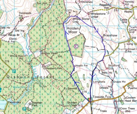
WHELP STONE CRAG – Gisburn Forest.

                            Distant view of Whelp Stone Crag peeping out of vast acres of Gisburn Forest.

I parked in Tosside; a church, a village hall, a war memorial in the middle of the road and an inn that is closed.

St. Bartholomew.

War memorial and ‘pub’


On the map the track leading to Whelp Stone Crag looked straightforward, a lane to a farm and then a footath alongside Gisburn Forest. As far as the farm the lane was good but the path onwards diabolical, difficult to follow on the ground, encroaching trees and waterlogged for most of its length. Why do I always seem to find these horrors?  I could hear the mountain bikers on the Gisburn Forest trails whooping with delight, I hope they could not hear my cursing. I would not recommend this approach, there are probably better traks within the forest.

The crag in sight over more rough ground.


Anyhow I arrived at the trig point, 371m, on top of a fragmented gritstone edge. Ravens were cavorting about in the updrafts. There must be some good bouldering on these rocks. From here I could look down on the bikers speeding along the trails. There were 360 degree views over Pendle, Bowland and into Yorkshire although the higher peaks were cloud covered. I was the only person up here.

After a snack as I was preparing to leave a couple arrived on the summit. ” That was the worst path we have ever been on” was their opening conversation. I had no idea what they meant.

The ongoing ridge was a delight before trackless slopes took me down to squelshy fields where farmers were rounding up their sheep. Across the valley, A65, were the limestone hills of the Settle area.

The unmarked footpath just about navigated me through or around, I was never sure which, several farms called Brayshaw. They all had a well worn look to them and were undoubtably of vintage.

Passing a smarter residence I reached some tarmac on a minor road. I threw in the towel and followed it back to Tosside. I think I was in Lancashire most of the afternoon but the oulook was Yorkshire Dales country.

*****

LONGRIDGE SLATE POETRY – Dark clouds gathering?

On many of my local walks up on Longridge Fell since the pandemic started I highlighted the uplifting poems written on slate and scattered about the region. I still do not know the originator of these pieces of art. Each one has been chosen for its content – nature and the environment; humanity, compassion and hope.

Today I have a stroll around the village itself to discover even more poems.

When I wrote about Longridge in March it was virtually a ghost town, but time has moved on, we have relaxed and ventured out shopping again. The coffee shops have a new lease of life. Today in the blue sky and sunshine the streets were busy, but with many people wearing their masks between shops. A new normal as the infection rate rises?  The virus’s hand is on our shoulder warning us of a bleak Winter to come. In that context the poems take on a life of their own – interpret them as you wish, but we should embrace  their optimism.

The latest slates in no particular order…

There may be more painted slates lying unnoticed in the village, I’ll keep looking. I think we may need their solace in the months to come.

On my walk I had a song constantly nagging at my mind …

RIVER WENNING AND ‘THE BIG STONE’.

The River Wenning comes out from the Craven limestone dales and heads towards the Lune.  Today we were constantly reminded of the Dales by the presence of the Three Peaks on the horizon. The river takes its name from the old English ‘wan’ meaning the ‘dark one’ and within yards of the carpark we were crossing its rushing brown waters. These waters in the past powered mills in the Bentham area, originally for flax but later turning to cotton and silk. Here at Low Bentham modern accomodation has been developed in some of the old buildings.

It was a pleasure to walk upsteam chatting to Sir Hugh especially after the last few stressful weeks. Before we knew it we were in a massive caravan park, part residential and part tourism. We were impressed as to the quality of the park but what would you do here all the time.

After exracating ourselves from the park we climbed little used paths linking farms up the side of the fell. Some tidier than others.

Fourstones Farm

Once on the open fell the object of our walk appeared on the horizon across boggy terrain. The Great Stone of Fourstones stands on the Lancs/Yorks boundary. Known locally as ‘the big stone’, it is a glacial erratic gritstone. Originally as the name suggests there were three others which were broken up by farmers, but I can find no reference as to any dates or why one stone survived. A feature of the stone is a set of worn steps carved into the side, easier to climb than descend. I remember playing here with my children and finding more adventurous ways to the top. Today we were entertained with an ascent by a passing motorcyclist in his unsuitable footwear. The stone is covered in carved graffiti.

Leaving here we weaved a way across the fell to descend past interesting farms with the dramatic view of the Yorkshire hills ahead of us.

Gragareth, Whernside, Ingleborough and Penyghent.

Grusckham.

A late lunch was taken sat on a couple of stones only to pass a perfect wooden seat within a hundred yards. This is a frequent occurence on walks which remains an unexplained quandary.

Dawson.

From time to time we were strafed by Chinook type helicopters which had the conversation ranging to ‘Mash’ – Hawkeye, Hot lips and Radar. We are of a certain generation.

Back on the River Wenning we bypassed Higher Bentham village using a lane by riverside mill cottages. Once through another large caravan park we took paths on the north side of the river to Lower Bentham.

Sleepy Lower Bentham.

Yet another interesting walk in unfamiliar territory. Are there more in this area?

*****


LITTLEDALE. A bittersweet day.

                                                                   Bowland at its best.

I walked here a week ago, August Bank Holiday Monday. We had planned it to avoid the crowds. Sir Hugh’s write-up is already published.

On my drive home I had a phone call to say my friend with dementia and motor-neurone disease had suffered a turn for the worse. Was I glad I had not taken the motorway, it was jam packed. My little car sped through the by lanes and I arrived along with the paramedics. There was little they could do except offer sincere empathy, likewise the on call doctor who came shortly afterwards. Thankfully she could be nursed, unconscious, at home. Two days later she passed away peacefully. I’ve lost two of my best friends this year.

A week later I have loaded my photos but am unable to give a  commentary.

Baines Crag carpark.

Artle Beck.

Crossgill Farm, 1681, typical of the area.

The former St. Anne;s Chapel. 1752.

Littledale Free Church, 1849, now a store.

Littledale Hall and buildings, C19 gothic style. Now a ‘therapy centre’.

Sir Hugh entering upper Littledale.

Leafy Littledale.

Over to Roeburndale – another day.

Littledale – there and back.

I want one of these when the time comes.

Littledale Hall again.

Caton Moor wind turbines.

Slopes of Clougha with the infant River Condor.

Looking back towards distant Ward’s Stone Fell.

Baines Crag.

A steep end to the day.

*****

ALZHEIMER’S DISEASE – a personal view.

Covid Lockdown. I’ve not been for three months. She must wonder where her friends have gone. What’s app video conversations have been intermittent and unsatisfactory. But I’m looking at it from my perspective, maybe she loved to see my face on the small screen, I certainly had the thumbs up even when there was no speech left.

At last, I can visit in the garden. As I walk in front of the windows up goes the thumb, only one now. How wonderful.

The combination of her deterioration and the Covid lockdown has not been good so I’m overjoyed with whatever recognition there is. There are stories everywhere of family’s unable to be close to their loved ones in life and death. All heartbreaking.

Dementia is cruel and insidious. Maybe two years ago there were early signs, slightly odd comments but we laughed them off. Then it was all too obvious but we kept on with life as much as possible. Even last September a holiday at their house in France. Old haunts were reassuring, maybe for her but helpful for us.

The trips out in the autumn to pubs for lunch. A finger pointing at her watch when the hour was twelve – they were serving food.  Signs language told me, if not the waitress, fish, no batter, chips and mushypeas. Maybe room for apple pie and custard. Some establishments were more understanding and accomodating than others. I’ll patronise those again when the pain is over.

But now a bare six months later there is only a glimer of recognition, a stare and possibly an attempt at a thumbs up. And now a stare

I talk and gesture almost a dementia in myself, thats all I have. A stare

I dread tomorrow, if she is not in the familiar chair.


ANOUSHKA SHANKAR.

Following on from a post by Sir Hugh [ http://conradwalks.blogspot.com/2020/08/the-first-night-of-proms.html ]  this is why I pay my TV license. 

I’ve just watched/listened to a brilliant display of sitar playing by Anoushka Shankar, daughter of the legendary Ravi Shankar on BBC Four, part of their Proms season. There was no audience this year because of  Covid 19.

The first session was with an electronic mixer Gold Panda twiddling the nobs. Mind blowing, you just have to listen to it.

The second session was with a strings orchestra and Manu Delago playing the Hang drum, which looks like a wok. Inspirational.

I hope it will be still visible on catch up TV  – if you have paid your license.

https://www.bbc.co.uk/events/erfz3d

https://www.bbc.co.uk/iplayer/episode/m000m7gz/bbc-proms-2020-anoushka-shankar-and-gold-panda