Monthly Archives: March 2023

IF YOU GO DOWN TO THE WOODS TODAY…

P1000138

A follow-up to my post of last week on Woodland Trust sites in Fulwood.

I had to go into Preston to pick up my camera after its repairs. Wilkinson’s has served me well over the years and many cameras with personal care.. My pocket Lumix Leica had started with a fault  involving the electronic zoom – it wouldn’t. I persisted for a while using the manual setting but eventually returned it to the shop for attention under its two-year warranty. The young shop assistant tried to tell me I had damaged the zoom by dropping the camera, I explained I hadn’t. He wrote about ‘damage’ on the repair form and said he would speak to his manager – he didn’t. Subsequently, I was informed the camera’s zoom mechanism was replaced and ready for picking up at a charge of £167. I phoned to say I had disputed the cause of the failure and expected the warranty to cover the charges, the temporary assistant said he would speak to the manager – he didn’t.

I arrived in the shop clutching my warranty and asked to speak to the manager. He was very understanding and agreed that the repairers had said there was no sign of any physical damage. Of course there was no charge, I thanked him for his fairness. I will no doubt be giving this independent but expanding business, my custom in the future as opposed to the internet. Just don’t deal with the young temporary assistants.

Being keen to try it out and as I was in town I thought I would visit the two Woodland Trust woods in Fulwood omitted last week. They didn’t fit into my circular walk being more stand-alone sites. The Woodland Trust website gave me maps and access points.

ASDA WOOD.

“Public access is informal and limited. There is a stile on the southern boundary which is used irregularly as a foot access route to Asda, a network of informal unsurfaced paths run through the site for approx. 500 metres. The woodland is not thought to be well-used except perhaps by a small number of people as a shortcut to the superstore.”

The small size of this site, and the fact that it is surrounded by housing and a superstore limits its value as a wildlife habitat. Unfortunately the woodland does not l ink with any other habitats, and there is no opportunity to extend it. However, it is a mature and stable woodland which provides a refuge for urban wildlife.

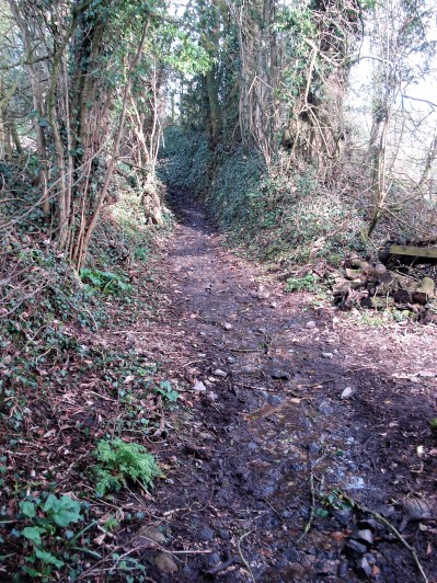
Not exactly encouraging. I parked up in the far corner of the superstore car park and found the shortcut mentioned, a muddy informal track connecting to Eastway. What else did I find? Well everywhere along the border of the wood with the car park an unbelievable amount of dumped rubbish. Not just the odd drinks bottle or takeaway box, no everything but the kitchen sink. There was probably a sink in there somewhere. A lot of the mess was Asda packaging hurriedly discarded whilst on the premises, but others must park up here, well away from the public eye, and have a right clear-out. It was disgusting, and I am surprised Asda  are not sufficiently ashamed and embarrassed to do something about it.

My enthusiasm for the oaks, birch, hawthorn and sycamore dwindled – it was so messy at the edges. The woods drop away steeply and would be difficult to access even if there were paths. Best stay away, or at least just sit in the car park listening to the bird song whilst you throw away your rubbish. I notice The  Woodland Trust does’n put their usual signs up here, or more likely they have been burnt.

P1000132

P1000130P1000131P1000121P1000123

P1000122

Eastway gate into Asda Wood.

P1000128

Deeper in the wood.

CLOUGH COPSE.

A popular wood with local dog-walkers and joggers Clough Copse consists of a wide variety of tree life including oak, ash, sycamore, cherry, beech, elder, hazel and holly. Bluebells, dog’s mercury and red campion can be spotted as well.

Sounds more promising. I’ve never been into these housing estates alongside The Guild Wheel.  A maze of roads, upmarket houses and plenty of green spaces. From one of the roads where I parked I eventually found a path onto the Guild Wheel which I followed downhill towards the Old Tannery on Savick Brook. On the map I had spotted a track heading back up into Clough Copse. This well maintained way alongside a smaller brook is local authority owned. There are bridges and steps leading off into  unseen housing. The deep clough divides and there didn’t seem to be any track up the right-hand branch. The Woodland Trust announce their presence. I followed the pleasant left-hand clough and yes there were dog walkers about.

P1000133

Out of the estate to the Guild Wheel to start.

P1000136

Finding a way in off the Guild Wheel.

P1000137

P1000139P1000140P1000141P1000143

A small ‘smoke-free’ children’s’ playground appeared on the edge of the housing. I continued upwards with the stream below giving interest. Patches of Wood Anemone, Lesser Celandines and Primroses added colour. Only the Blackthorn was showing any blossom.

P1000148P1000144P1000145P1000160P1000146P1000134

All too quickly I popped out the other end onto some unknown road and was able to find my way back to the car. Really this wood is just a narrow strip  offering locals a welcome green way out of their estate. Again there was plenty of bird song, so it is providing a habitat for our wildlife.

P1000152P1000151P1000153

tempsnipASda (2)

!. ASDA WOOD.     2. CLOUGH COPSE.   Purple, route walked.

Maybe Clough Copse would be worth a revisit when the bluebells are out and the trees leafed up. But really it is only of use to the surrounding estate. Stay well away from Asda Wood.

My curiosity satisfied and the camera tested. Now after the two visits I have in my mind’s eye an idea for a pleasant walking circuit of the best of the Woodland Trust sites in Fulwood. But let’s wait until the woods are farther on after Easter.

CICERONE’S LANCASHIRE – let there be light.

P1000084The clocks have changed, but my body hasn’t caught up as yet. Today had a sparkling alpine start and promised to be the best of the week. I struggled to get up having lost an hour somewhere. But with the minimum of faffing I’m away by 10.30. It only takes me a half hour to drive out to Dunsop Bridge. I know the sun doesn’t set tonight until after 7pm, so there is no rush, that’s the way I like it.

 Walk number 12, Whin Fell and Brennand, of Mark Sutcliffe’s guide promises – Another classic hill walk  combining steep climbs, big views and pleasant riverside rambling in the secluded hills and dales at the heart of the Forest of Bowland, 

 He has covered Bowland well with ten walks on my back door. Today I parked up just off the Trough road as recommended. Soon I was following a permissive path alongside Langden Brook. Oyster Catchers seem to have taken over many of our rivers but in the background I could plainly hear Lapwings and Curlews. This is open fell country,but since 1960 their numbers have dropped by 85%.P1000019P1000020

P1000023

Crossing Langden Brook.

Back on the road I pass the farmstead of Sykes.

P1000025The lime kiln gives a clue as to the bedrock hereabouts, but I shall soon be high in gritstone country.P1000026

The Trough of Bowland road snakes ever so slowly up the valley. I branch off right and have my own hill to climb.

P1000038The track soon peters out, and I’m left on boggy pathless territory forever upwards. This is designated as a bridleway, and I remember coming this way on a mountain bike 35 years ago with my son. No chance now. This area is isolated from the usual Bowland haunts, and I’m surprised to meet three walkers descending the pass. A friendly trio and we exchange banter. They have driven up from Manchester,  preferring this area to the crowded Peak District. They soon become a dot on this vast landscape as they descend towards the Trough Road and I struggle upwards. Across the way Totridge Fell keeps its head above most of the fells around here.

P1000039 (2)

P1000050

P1000063

The last time I was up here I continued to the top of Whin Fell with views to Morecambe Bay and beyond. This certainly feels like the centre of Bowland. Today I was conserving my energy to complete a rugged 7-mile circuit. and I soon reached the boggy col. Way down in the valley was Brennand Farm – the promised land. All I had to do was traverse Ouster Rake. It wasn’t as bad as I remember it. Over the years a groove has been eroded into the hillside making it feel far less exposed. But come a harsh winter and this becomes an icy trap where there have been several accidents. I still don’t believe I have cycled this route. I find a flat rock and eat my sandwich gazing down into the Brennand Valley, I must follow it higher into the hills one day, I don’t think I have ever been to the evocatively named Whitendale Hanging Stones.

P1000059

P1000078

P1000077

P1000069Looking back I was surprised to see how steep and craggy are the northern slopes of Whin Fell. At Brennand Farm (notice how it complements Sykes Farm passed earlier) all is pleasant with newborn lambs in the fields, no Spring walk is complete without some lamb photos. On down the Brennand Valley and then strangely back upwards to join Whitendale.P1000087

P1000092

P1000097

P1000101

P1000104

Looking back up the Brennand Valley.

From the water catchment works under Middle Knoll the River Dunsop gathers pace down the valley. All very familiar to me. I, too, gather pace alongside it on the good tarmacked water board road. I stop to try, unsuccessfully, to capture a photo of the Dippers merrily skimming down the river.  Sometimes Kingfishers flash up this section . There has been a lot of tree felling along here in the last few years. I’m soon onto those boggy fields I traversed last week to get me back onto the Trough road below Mellor Knoll and Totridge, and my car. There is plenty of light left for further exploration. Don’t get your Middle Knoll get confused with the Mellor Knoll.

P1000106

Joining Whitendale.


P1000108

Middle Knoll overlooking the Dunsop Valley.

P1000109

P1000113

Across the fields with Mellor Knoll and Totridge ever present.

CaptureWhin Fell

Post script. You will recall my horror the other day at the erosion being caused in the beech woods on the lower slopes of Totridge Fell above the Inch Perfect Trail Bikes outfit. Well let’s take the bull by the horns and drive up to their headquarters. It’s a long lane up to ‘New Hay Barn’ as it was. Now the centre for trail bike riding with accolades from Lancashire Tourism. I must admit they have developed a professional trail biking heaven. Lots of  manufactured technical obstacles in the lower fields for the enthusiastic biker.  I enter the impressive shop full of no doubt expensive bikes and kit, electric ones being top of the range. Videos are playing of the destruction they are doing to the hillsides. All very Formula One. 

P1000117P1000119P1000116

Simon the manager is on the defensive as I casually say I had been on the public bridleway on his land last week and was distressed  to see the erosion and damage being perpetrated in the beech woods above. He asserts that all has been verified planning wise, though I doubt the fine details. He seems to imagine, erroneously, that the bikes don’t go as high as the woods. His main grouse is dog walkers at loose amongst his trail bikes, albeit on a public bridleway. Being in a mellow mood I forget to ask him who actually owns the land (is it Duchy Land?) and does he have marshals out on trial days to warn the public  of the surrounding danger. We part with him saying he will have to have a trip up into the woods where I am showing concern. He has not seen the last of me. This is an Area of Outstanding Natural Beauty after all. Or is it?

Calm down. As I leave ahead of me is one of my favourite Bowland venues, Kitcham Hill Woods on Birkett Fell. All peace and quiet, long may it remain so, but I do wonder who will be looking after our countryside in the future.

P1000118 (2)


CICERONE’S LANCASHIRE – Whitewell, Mellor Knoll and the Hodder.

DSC00293 (1)

Haredon rook connects with Langden Brook which connects with the Hodder just after the River Dunsop, itself formed from the Brennand and Whitendale  waters, has joined in. In this part of Bowland there is a lot of water flowing off the hills down the Hodder towards the Ribble. So much water that I couldn’t safely cross the stepping stones at Whitewell this morning. Walk number 14 of Mark Sutcliffe’s Cicerone Lancashire. 

DSC00448 (1)DSC00445

The day promised the best weather of the week – sunny,mild and dry. And it was. I adjusted and parked up at Burholme Bridge a little farther up the Hodder.

The climb up the quiet road was a good warm-up before taking the footpath through the field.  It felt good to see Lapwings flying around and a couple of Curlews in the distance. I was in limestone country and all around were little outcrops and caves, I have explored some of these in the past so was content to walk by. The lane leads into the hills and a far off farm under Totridge Fell, but the bridleway goes off right into the woods. At one time there were numerous hen houses scattered about, true free-range poultry, but today there only seemed to be one shed left standing. 

DSC00300

Unnamed limestone caves.


DSC00307

The ‘last’ Whitmore hen house.

The path through these woods, Lower Fence, has always been boggy but since recent felling matters have improved somewhat. As height is gained views open up into the heart of Bowland above Dunsop. Leaving the firs a contrasting beech wood is entered. I have always enjoyed this high woodland stretch – beautiful beech trees with Totridge Fell towering above and views down through the trees to the twisting Hodder where I had parked. The farm below has hosted off-road motorbike trailing for some time, but it was confined to the lower fields and contrived obstacles. Inch Perfect Trials. There is now evidence that they are riding higher up into these ancient woods causing erosion and damage to the tree roots. Their promotional video illustrates this clearly. No doubt the land belongs to the organisation but, call me a spoil sport,  I don’t feel this is appropriate in the wild surroundings. Worryingly they seem to have received several Lancashire tourism awards. We don’t need that sort of tourism. Let’s not forget we are in the Forest of Bowland, a recognised Area of Outstanding Natural Beauty. I certainly would not like to walk this Public Bridleway when they are out to play. Who should I complain to? The King, if this is Duchy land? Now I’m home and writing this I am even more incensed – they are going to destroy that beautiful beech wood.

DSC00316

How it should remain.


DSC00313

Encroaching trails.


DSC00319

The Hodder Valley below.


DSC00322

What it is becoming.


DSC00323

Erosion…


DSC00321

…erosion


DSC00325 (1)

Destruction.

Maybe my mind was distracted, but I went astray at the col between Totridge and Mellor Knoll. It is easy to do so on the featureless ground. But basically all routes lead down to Hareden in the end. Incidentally if you are up here it is easy to gain the 344 m summit of Mellor Knoll, although there are no rights of way. Why wasn’t it included in the CRoW act’s open access land?

DSC00334 (1)

Mellor Knoll.


DSC00338 (1)

Off track.


DSC00344 (2)

Haredon, can you spot the car on the trough road?

At the farm a trailer was full of sheep presumably off to market. When I asked the little girl with her mother if they were her sheep she proudly said yes. the mother quickly intervened to say that they were going on holiday. Very diplomatic. 

DSC00349

Going on holiday!


DSC00352

Haredon Farm. 1690.


DSC00350

Always a warm welcome.

it was flat walking down the valley into Dunsop Bridge, but the weather had clouded over and become much colder, don’t we have a mixed climate. Mark’s route fortunately brings you past Puddleducks café, still functioning as an outside venue, I enjoyed a coffee. 

DSC00354

Hareden Brook, haunt of Dippers.

DSC00355

Langden Brook.

DSC00401

Puddleducks in the old post office.

DSC00405

On past that 100.000th BT phone box often considered the centre of Great Britain. Down the avenue of tall Redwoods to Thorneyholme Hall, once owned by the Townley family of Burnley, known for breeding race horses. Their land agent Richard Eastwood had success in the 1861 Derby with Kettledrum. It is believed that St. Hubert’s Church in the village was partly financed though the horse’s winnings. More of that later.DSC00408DSC00411 (1)

The path down the valley alongside the Hodder, now joined by the Dunsop and Langden Rivers, is always a joy surrounded by all those familiar hills. This is a good place to watch Sand Martins but of course they haven’t returned yet. The river bank in parts is being eroded, and the path has been changed with the introduction of those modern metal kissing gates which I don’t feel are very sympathetic with our countryside. That is the last of my gripes.   

DSC00415

Langden Brook joining the Hodder under the watchful eye of Mellor Knoll.

DSC00417

What’s wrong with the old one?

Since I was last along here the farm at  Burholme has had its rendering removed exposing lovely warm sandstone. The farmer busy with his lambs tells me it has C14 origins. Their Lonks are not to be messed with.DSC00423

DSC00419

By the time I was back at the graceful Burholme Bridge the sun was shining again.

DSC00436

I then drove back along to Dunsop Bridge to have a look at St. Hubert’s which I had become more aware of through  this blog.  All the history is there to read and I won’t repeat it. See also its listed building entry. The church sits squatly by the road leading to the Trough of Bowland.  The striking feature externally is the large white marble angel guarding the Towneley family vault. Inside I found very little lighting to fully appreciate the fittings. The exquisite stained-glass windows however showed up really well. Their leaflet describes a painting of Kettledrum, but I was unable to locate it. Mary Towneley  of more recent equestrian fame is also buried here. 

DSC00388

DSC00391 (1)

A good walk in the best Bowland scenery, which in truth I have done many times before at all times of the year, but never get tired of. (I did exactly the same walk on May 1st 2019.)  If you are intending to follow the Cicerone route in full come when the river is down so the stepping stones can be traversed and maybe a pint taken in the Inn at Whitewell.  There is a concessionary path off the road from near Burholme Bridge directly back to the Inn at Whitewell which would save some of the repetition of his route. 

DSC00451 (1)DSC00458                

CaptureHaredon

DSC00448 (1)

SOME FULWOOD WOODS.


DSC00440

David Attenborough has just told me and the rest of you on his latest TV documentary that the UK has the worst woodland density of any European country. That does not surprise me given our government’s rough shod treatment of our environment. They don’t even approve of Attenborough’s climate predictions. Who would you trust our natural treasures to – David  or Sunak, Hunt, Coffey et al.  We are woefully short of natural diversity and though it is small scale  The Woodland Trust charity have something to offer on a local level and potentially a wider scale the more people know of them and their work. But how much more we need to do to re-establish our natural woodlands after years of local destruction for housing, transport, agriculture and sterile forestry plantations.

This was to be an afternoon of exploration which will be of little interest to most of you. Fulwood lies to the north of Preston hard by the M6. A land of suburbia, upmarket houses and expensive cars. And it is spreading fast to link up with Broughton and Cottam. New estates appear by the month and roads struggle to cope with the traffic. Alongside the motorway industrial units and office blocks use up most of the remaining land. So what is a ‘mountain man’ like me doing here? Well for a start mountains are off the agenda until hopefully the knee has improved. Secondly I noticed on a walk on the Preston Guild Wheel last week lots of tempting linear woodland walks. Most of them signed and presumably maintained by The Woodland Trust charity. A fellow blogger Clare highlighted some woods in the area a year ago, and I have to thank her for that. It lit a spark in me, and I am off to discover what has been hidden under my feet or wheels all those years. 

A bit of research on The Woodlands Trust website  showed an interactive map of all their woodlands. I focused in on the Fulwood ones.

Capturewoodland Trust

Armed with a sketch map I left Fulwood Row onto the Guild Wheel through Hindley Hill Woods. ( Fernyhalgh Woods  according to the Woodland Trust Map, but let’s not quibble. On the east side of the Motorway alonside Savick Brook they are named Squire Anderton’s Woods. I traversed these on my Haighton walk last week) This is all familiar territory but once I crossed Longsands Lane I diverged from the GW north into Midgery Woods, crossing Savick Brook, and going uphill towards the constant drum of the motorway. The path goes alongside the motorway for 300 metres with expensive looking houses to its other side, they must be glad of the belt of trees to give them some insulation from the noise. One could carry on along here all the way to Moss Leach Woods, but I’d had enough of the noise so took a pleasanter path through trees over the roundabout and re-emerged back onto the GW at Midgery Lane. I followed the Wheel northwards until I came to the entrance to Moss Leach Woods on the right. I had a quick foray in the woods towards the motorway out of interest before continuing.


The Guild Wheel.


Savick Brook.

Heading to the Motorway.

On the map is marked Cromwell’s Mound in a field just off the Guild Wheel – I had never noticed it before. A public footpath crosses the field here just south of the mound which to my surprise was clearly visible, although I need a better photo. ‘Cromwell’s Mound  fieldwork remains in good condition and is a rare example of a monument associated with the Second Civil War of 1648.’  For the full history behind this mound have a read here.  The developers have encroached upon this historic site with the planning departments colluding.

A fuzzy Cromwell’s Mound.

I should have just carried on across the field but instead retraced my steps and followed a narrower path continuing in the Moss Leach woods by the stream. This was very muddy and came out at the same place as the Public Footpath – lesson learnt. I was now on the busy Eastway, again I could have gone straight across, but I wanted to look at the strip of woods heading south from the road just past the roundabout. Walking alongside this road is not pleasant. Thankfully the strip of woodland was signed, and I enjoyed a good stretch.  I probably passed over the moat of the demolished Broughton Tower along there somewhere, another one to come back to. The path narrowed alongside houses, and then the way continued onto Tower Lane, showing cobbles in places near Tower Farm. This made up lane. now between upmarket properties, came to a T-junction. With the lack of knowledge of any other ways I turned left and soon reached Eastway again.  I walked down the grass verge, there being no footway, until I reached the entrance to Mason’s Wood. Looking at the map I could have reached this point  more easily from the Guild Wheel, cutting out the loop to Cromwell’s Mound. but that wasn’t the point today.   

North end of what had been Tower Lane.

Tower Farm.


How much?


Eastway – best avoided.

Mason’s Wood was a gem. a deep wooded valley with the path winding along it. Little bridges lead to paths rising to the housing on the west bank, whilst hidden on the left was Preston Golf Club. This could become a favourite of mine. The wild garlic was just leafing up. 

Entrance to Mason’s Wood.

DSC00388 (1)DSC00389 (1)

At the end a footbridge took me across Savick Brook and onto the edge of the smart looking golf course, complete with its usual warnings and arrows. But all went well until a muddy exit back onto Eastway which I then followed until Fulwood Hall Lane on the right. To escape from the busy road I ducked down here and found a path following Savick Brook upstream. I still had to cross and recross the busy roads again at the roundabout to continue upstream. That bit needs sorting out.

Savick Brook again.


Preston Golf course.

DSC00418


The light was fading, I hadn’t set off until 3pm due to faffing, so I increased my pace along the good path. This linear wood is called Sandybrook, another Woodland Trust site, and is three quarters of a mile long. (Header Photo of Sandybrook) All these hidden woods. It was only in this section, bordering onto the Brookfield estate that I encountered any serious litter. Most of the woods had been clear of rubbish and thankfully poo bags.

Entrance to Sandybrook.

At the end I emerged back onto Fulwood Row, the end of my walk, just as the rain started. Here were present day reminders of the natural habitats we must have lost whilst this area was being and still is being developed, but credit to The Woodland Trust for preserving some of these linear wild life spaces.

Extending Fulwood Row!


This is a fairly mundane write-up, out of necessity, to find, explore and possibly link up the various woods. There is so much green space hiding away from the busy roads in the area, Strangely I feel I have had a good ‘country’ walk today. What must it be like when the bluebells are out and the trees showing much more greenery? Already I can see how to tweak the route to avoid the dreaded Eastway, yet still experiencing the best bits. Today I  walked about six miles, but I think an excellent route of about four miles avoiding roads would be possible. The green lungs of Fulwood. My convoluted route is shown on the map below, but I’m sure there will be more to come of these woodland walks in the heart of the city. (Is Fulwood in the city?)

The Woodland Trust site shows two more woods I didn’t or couldn’t incorporate into today’s walk. Asda Wood and Clough Copse. I will make a separate trip to these, and maybe incorporate a bit of shopping at Asda at the same time. Additionally, their website has some very good information on tree identification and other matters natural. Worth a visit and a donation at https://www.woodlandtrust.org.uk/

***

CaptureFULWOOD

CANAL AND COASTAL CALM, UNTIL…

DSC00392

What a relief to find Sir Hugh at home, I needed a cup of tea and a sit down. I had just struggled to finish a 25mile bike ride. As I left Morecambe along the old railway line I seemed to be tiring fast despite having eaten well. Cyclists seemed to flash past me, I made the excuse they must have electric assistance. I had just travelled through what I consider a dodgy section of the cycleway. A haunt of drug addicts and other undesirables. One had just tried to punch me as I passed, try ducking and slipping on a bike. He just missed, probably because he was drunk.

After a few more hundred yards I was coming to a standstill. Only then did I look at my back wheel – the tyre appeared awfully flat. I suspect I had ridden over some glass in that dodgy area. Five miles back to my car at Halton, should I just battle on. I did have a spare inner tube on me, but it would take quite a while to fix in these cold conditions, so I peddled on becoming slower and slower. At a bench entering the city I stopped –  A. for a rest and B. to try and pump up the tyre. The former helped, but the latter lasted about 50 yards before I was reduced to a crawl again. Only three miles to go, so I got off and walked for long stretches The afternoon’s rain was coming in fast, so I remounted and pedalled as best I could to reach the car just as the down pour started. I was knackered and hence the need for a visit to Sir Hugh. I can sort out the puncture tomorrow at my leisure, why is it always the back wheel with all its complicated derailleur gears?

The day had started far more optimistically, cold but dry as I pedalled up onto the Lancaster Canal Aqueduct over the Lune. We have had some topsy-turvy weather this week. But now all was peace and quiet, even the dog walkers stopped and held their precious pouches until I had passed. Good progress was made along the towpath, here in reasonable repair – in contrast to that leaving Lancaster to the south, which can be a nightmare on a bike. My plan was to extend my usual route by cycling onwards to Carnforth. I love this elevated stretch above Hest Bank and Bolton-le-Sands with views down to the coast. Carnforth was busy with a market in progress. My route took me past the infamous station, the last time I visited it for a ‘brief encounter’ in June ’22 I ended up with Covid. I hesitated before repeating the process but the thought of coffee and cake was too much. I had awoken this morning to find I had no bread or little else to concoct a sandwich. All was cheery and friendly in the 1940s café –  a good latte with  a slice of iced flapjack did the trick.

DSC00363

Lancaster Canal Aqueduct over the Lune.


DSC00366

Sailing high above Hest Bank.


DSC00369

Woodland approaching Carnforth.


DSC00373

Brief Encounter.

Refreshed I continued alongside the River Keer, under the threatening Main Quarry on Warton Fell. Deceptive bends and plastic icebergs re-emerge into my conscience, it was always a frightening place to climb. Onwards without destroying the peace.

DSC00383

Warton Crag and quarry across the marshes

Soon I was back on the canal, reversing my morning’s route. If only I had just ridden back along it to Lancaster.  Bur no, I could not resist turning off at Hest Bank to cruise down to the promenade and follow the Bay into Morecambe. It’s becoming a habit. The tide was out and one could hardly make out the sea.  It’s different every time I come along here, that’s the charm of Morecambe’s seafront.  I sat on a bench looking out across the bay.

DSC00395

Bench on the bay.


DSC00299

Morecambe’s cormorants.


DSC00399

Low tide walk about.

Then all my troubles started.

***

CaptureCarnforth.

***

As a footnote I have to thank Sir Hugh for his hospitality at short notice. A few of you I know follow his blog and will be aware of is modelling skills. Well here is the professor in his modelling den.

DSC00402

HAIGHTON VARIATIONS IN TURN.

DSC00350

***

An urban rural walk.

Call me a wimp or whatever, but I’m keeping my walks to lowland lanes at the moment. Good surfaces and a modest distance. I’m rather pleased I didn’t cycle today as to start there was a fresh wind which seemed much stronger than the forecast suggested.

Haighton is a scattered farming community to the east of the M6 between Fulwood,Preston and Grimsargh. Possibly best known for the C17 Haighton Manor, a well respected and longstanding dining establishment.  I have included walks through Haighton in the past  here and here and briefly here.

Coincidentally these other variations were all walked in the early quiet Spring months, as of now.  “For everything there is a season” Ecclesiastes 3:1-8.  A time, add another turn for Haighton. Also, time for a tune, a bit of optimism doesn’t go amiss at present. I remember hearing many other artists covering this song during  the 60s live folk scene in London.

A good reason to repeat parts of those walks today is that Haighton Green Lane was closed to through traffic due to new gas mains being installed. It is normally a busy rat run route in and out of north Preston with speeding motorists, not the safest of pedestrian routes.

I find a small parking space at the bottom end of Cow Hill and stroll down the hill to cross Londonderry Bridge over Savick Brook which winds its way down from Longridge. Ahead are the gates and security cameras of Haighton House, once  the residence of David Moyes when he managed Preston and then Everton. I slip up a narrow bridleway alongside the noisy kennels and climb into the woods. DSC00319

At the top was always a gate securely guarded by a fierce mastiff. The PROW went through the farmyard, but he ensured that one followed the ‘illegal’ diversion around buildings. But today the gate is open with no sign, hopefully, of the dog, but I still take the long route just to be sure. The amount of accumulated waste building materials dumped alongside the rural lane farther on has grown since I was last along.  DSC00321DSC00323

I come out onto Haighton Green Lane at the top. It is indeed closed to traffic but being a Sunday no work is taking place, (no wonder road schemes go on for months – one would think that if a closure was in place the contractors should work at full pace) Despite the narrow route some drivers try to squeeze through only to back up when they meet another vehicle. On the whole though the lane is peace and quiet.

DSC00326 I’m tempted to go off down Fernyhalgh Lane past the old school (where my children started) the church and Ladywell Shrine, a shortcut back to Savick Brook. But no, I need the mileage and the day is fine, so I continue on the road whilst it is virtually traffic free. There are some fine houses along here as well as the original farms. DSC00328

DSC00327Crossing the M6 motorway I stop to watch the southbound lanes coming to a standstill., a well-known black spot. Preston Bypass, as it was known then in 1958, was the first motorway to open in the UK.  Since those days it has been incorporated into the M6 with new junctions and carriageways. I try to avoid driving on busy motorways with their frequent hold-ups and after my frightening experience of breaking down last year on a ‘smart’ section of motorway that has been reinforced.

DSC00332

By now we are now on the edge of the countryside. Housing developments are met, creeping out of Preston along the once country road on both sides. I am no stranger to these as they are also engulfing the Preston Guild Wheel cycle route which I now turn onto. I slip past industrial units, smart new office blocks and the back of an Asda superstore. But it is traffic free and not so bad. Lots of people use these stretches for recreation, strolling, dog walking and cycling. Walking today instead of my usual cycling I notice more connecting footpaths going off in all directions and stretches of linear woodlands inviting investigation, many signed by that admirable charity The Woodland Trust. That gives me an idea for a time researching them and a day of exploration and maybe linking them together. When I think back I seem to member Clare of  Dreams and Adventures at Cosy Cottage  writing about them during lockdown.

DSC00336

DSC00334

DSC00340

The section of the Guild Wheel through Hindley Hill Woods above Savick Brook is always a delight and I turn off onto Fernyhalgh Lane, though I notice more woodland paths on the north side of the Brook I could have used. DSC00342DSC00344

Now back under the motorway, at the bridge I don’t climb to Ladywell  shrine but take the road into the grounds of Haighton House. A lovely stretch through the well-kept estate alongside the river. Then a more wild stretch above the convoluted water, an Ox-Bow Lake is obvious and soon there will be more, even the path has been washed away here. DSC00348

DSC00349

DSC00356

I’m soon back at Cow Hill and a climb up the lane to my car. DSC00358

The temperature had by now slowly nudged into double figures and I felt decidedly overdressed, but I’m not going to complain.  It was still only noon when I arrived back home, so I had time for a short bouldering session up at Craig y.   I was the only one there, I wonder why, after the crowds last Sunday. Compare and contrast,as my art teacher used to say.

DSC00360

This Sunday.

DSC00277

Last Sunday.

Variety is the spice of life.

***

tempsniphaighton

IN LIKE A LION…

DSC00304This week I have been alternating short walks and flat cycle rides with nothing of note to report. Everything came to a standstill yesterday with the collision of cold winds from the north with a front from the south. Amber warning. My son cancelled a lunchtime visit from Manchester and I watched the snowflakes falling in the afternoon. During the night things must have turned nasty as today I woke to a couple of inches of snow. (The radio told of far worse conditions in the Pennines) It was interesting to try and identify the  tracks across my back garden, one doesn’t know what transpires in the night. Something I should resolve either with sitting up into the wee hours or more likely installing a motion detecting camera.

By mid-morning the sun had appeared and traffic started using my road. Time to get out and about. The tossed coin said walk. So I did. A brand-new pair of lightweight boots had arrived in the post. Helly Hansen and looking perfect for summer walking – right let’s try them out in some snow. Living in Longridge I am lucky to be able to walk from my doorstep into the open countryside or as I did today up onto the fell. The route on roads was one of my regular runs way back then. I knew it would give me good Bowland views with the minimum of hassle.

Once out of the village ‘Forty Acre Lane’ gave me those promised views. I’m not sure which side the ‘forty acres’ are on but never mind the vista across Chipping Vale to the hills is uplifting. The snow on the south slopes was visibly melting as I walked but showed up the features of the Parlick, Fairsnape and Totridge Fells in great detail. Virtually no cars passed me, the road was just thawing enough for them. There were still drifts in the gateways. The golf course was closed, perhaps prematurely as the afternoon was perfect.

DSC00306 DSC00305

DSC00303

The usual crowd of cars was parked up at Jeffrey Hill. From up here the northern slopes of Pendle Hill were plastered with snow – they usually have it worse in East Lancashire. I was in two minds to take to the fells with the rest of them and visit Spire Hill, instead keeping to the road but no sooner had I decided this I was tempted off into Cowley Brook Plantation. My favourite getaway place. It was a joy to tread virgin snow through the trees. Silence was everywhere except for those little birds singing unseen. DSC00310

Back out on the lower road I trudged back along the switchbacks to Longridge as the temperature started to fall again. The roadside gorse was a brilliant yellow.DSC00302

How good that sunshine must have done for my endomorphins.

***

CaptureLongifdge fell

A NEW SEASON?

DSC00275 (2)

Trying to spread my diminishing physical  ‘talents’ around – walking, cycling and climbing. today after a miserable week of wheeziness and coughing I made the effort to drive up to Craig Y Longridge not that it is very far. Would it be a step too far? Possibly.

I’ve been coming here for years, far too many. I’m probably four times the age of the young dudes who come from afar to test their strength and skills on one of England’s premier bouldering venues.  This strenuous training crag (more correctly a quarry) is fortunately on my doorstep. Every spring I am determined to get strong again.

I’m surprised by the number of people here today, but it is dry with a glimpse of the sun and temperatures nudging above 6 degrees. We all climb in hope. The colourful crowd is mainly one group from Lancaster. All a friendly lot. Whilst they hurl themselves at desperate overhanging problems I slouch off to the easier far end where I can play around on some familiar traverses. I’m only feeling my way back to fitness but as I climb that old buzz kicks in, and I start to enjoy myself and pull off some  smart moves. But not for long – the strength soon runs out. Still, there is time to chat with the others, passing the time of day and reflecting on past days and crags. They tolerate my reminisces, I only hope time will be memorable for them too.

Well satisfied. I can but try.

DSC00277

New school bouldering.

MORE MORECAMBE.

DSC00181

You may wonder why I keep coming back to the Bay. My cycling is for leisure and pleasure these days, and there is no pleasure on the busy roads around Longridge. The old railways, cycleways and canal up here are ideal and one has the added benefit of the ocean breeze and those views across the bay. Oh, and it’s all relatively flat.

I suspect that sometimes I am bewitched by that view and neglect little details on the promenade. Well today I paid more attention to what was under my feet, I mean wheels, and I ended up walking stretches of the front so as not to miss things.  I had arrived onto the front near Heysham via a new route, for me, which diverged off the old railway/cycleway and wound its way through the White Lund Industrial Estate, lovely.

From the start at Sandylands I notice several, about three dozen, round interpretative discs set into the promenade telling the story of Heysham, Morecambe and the Bay. A quirky addition to the front. For a more detailed history and lots of old photographs and archive material it is worth visiting the Maritime Museum on the quayside in Lancaster. Morecambe has certainly had a chequered history – but the future with The Eden Project hopefully under way should be more positive. It is frightening to realise that I am part of that recent history, bringing my family up to the amusement parks and aquarium still in existence 50 years ago and now no longer. I try to remember if the central pier, mentioned more than once in the discs, was still standing on our visits. It is suspicious that there were so many fires on the derelict piers. DSC00195

DSC00182

DSC00189

DSC00190

DSC00193

DSC00203

DSC00208

DSC00210

DSC00211

DSC00209

DSC00217

DSC00226

DSC00229

DSC00230

DSC00232

DSC00192

Capturepier

Morecambe in the 1940s. The two piers highlighted.

So there you have it. On the way I passed this house painting, an old pier/breaker, a couple of turrets and these elegant Edwardian terraces. Fading glories.

DSC00228

DSC00218

DSC00248DSC00221As I approached the west end of Morecambe I was intrigued by a large building set back from the front. The building now known as The Battery once marked the boundary between Morecambe and Heysham. (in 1928 the two districts merged). In the nineteenth century the site was occupied by an old mill and the area was later used as a firing range, with an artillery battery stationed there because of fear of an invasion by the French. The mill, then known as The Roundhouse, was used for storing ammunition. The Battery Inn was built in 1863 and in 1900 it expanded to become The Battery Hotel, later acquired by Thwaites Brewery and functioned into the 1980s. It has recently been bought by a property developer for conversion into luxury flats. I’m not sure whether much progress has been made.

DSC00237

I don’t think the adjacent Beach Cafe is the best of architectural designs.

DSC00243

My informative circles had finished, but something on the road caught my eye –  half a car to cut your motoring costs, an effective advertising gimmick.

DSC00252And what’s more on the other side of the road a series of artistic panels brightening up an otherwise drab development hoarding at the former Frontier Land. I now remember Eunice from the Mouse House mentioning them here and here in far more detail than my pictures below. Local artists are highlighted. Several showing Eric the town’s celebrated son.


DSC00254

DSC00261

DSC00256

DSC00258

DSC00264DSC00263DSC00266DSC00260DSC00268

I hope the Midland Hotel is given anew coat of paint before Eden arrives.

DSC00240

By now my hands were frozen in the cold northerly wind whipping down the promenade. Time to get cycling again. On past the Midland, Happy Mount Park, Hest Bank and onto the Lancaster Canal back to Lancaster. I had just about warmed through by the time I reached my car at Halton. It’s only half an hour back down the motorway, but I have a sense of lingering guilt that I shouldn’t be driving farther than I’m cycling.

***

CaptureMorecambe