Tag Archives: Lancashire

VE DAY 75 CELEBRATIONS.


Lest we forget – I nearly did.

I decided to go out on my bike again today, partially to avoid people and secondly to explore further afield. Not that I don’t know ‘further afield’ in intimate detail. I pedalled off into the east and found myself coming into Chipping in the early afternoon. There was bunting everywhere and there seemed to be a street party underway, all well distanced. Only then did the realisation that it was the 75th anniversary of VE Day enter my all too isolated brain. I didn’t stop for an illicit drink but I wished everyone well as I cycled past. What a good turnout. Up at the church was a classic jeep and other period vehicles had been brought out to give some atmosphere. I felt a chump for not realising the day and forgetting the two minutes silence this morning at 11am.

I was huffing and puffing on some of the hills out of Chipping and I stopped at a gateway to take a photo down the valley. Along came a couple of cyclists, my friends Kevin and Shelagh. I last saw them just before the lockdown when I called at their house on a walk over the Chipping Fells. Today they were taking their exercise and hoping to buy some cheese at one of the local dairies. After pleasantries, they cycled off with S engaging electric mode. I continued more sedately enjoying the views and fresh air.

I arrived home within the hour pleased with my modest socially distanced circuit, my belated  VE Day observances and determined to go further tomorrow.

I’m praying the government doesn’t in the next few days unravel our attempts to slow the virus and protect our NHS.


*****

MIXED BLESSINGS.

I realised today I’d not been out on a walk for some time. What day is it anyhow?

Last week seemed fragile topsy turvy and the last couple of days I’ve been head down in the garden. I’ve finished painting the pebble dash on my garage and have cut down a Mountain Ash that looked decidedly unhealthy last year and has shown no sign of budding this spring. By tea time I was knackered so I set off on a walk.

I had two objectives. One was to explore a little further up onto the slopes of Longridge Fell putting some ascent into my walks and secondly to gather some wild garlic leaves and flowers for cooking.

The local cricket field was immaculate for ghost players.

It was a mistake to head out on the Chipping Road and go up Mile Lane. Half the population of Longridge were using this route and I was constantly being closely passed by heavy breathing joggers. I felt quite uncomfortable as up to now I’ve been more or less completely self-isolated.

With relief, I entered field paths near the top of the lane, Old Rhodes,  where I could relax and take in the views. I don’t think the pheasant jogging past posed any risk.

I wandered down a rough lane to pass through Little Town Farm. This is a mainly dairy herd farm producing thousands of gallons of milk from their automated milking parlours. A few years ago they diversified by making yoghurt and opened a farm shop, cafe and small garden centre. It has become a popular destination for the locals to lunch out and buy fresh products. Due to the Covid19 restrictions, the cafe and garden centre are closed although there is limited access to the farm shop. Thankfully they are able to distribute most of their milk to the local cheesemakers while you hear of other farmers having to pour excess milk away.

Across the road and I was heading down to Ferrari’s Country Hotel and Restaurant, another place affected by the virus lockdown, they are doing takeaways to tick over. This is where I was able to pick the garlic and also get a glance of flowering bluebells which I’d missed so far this year

.

The evening sun was delightful as I followed familiar paths home through lush green fields with the Bowland Fells in the background.  For supper, I enjoyed a poached egg on a bed of garlic leaves with new potatoes.

In future, I will avoid the lanes close to the village, why don’t I get it right in the first place?. The spring sunshine was a tonic but I was really unhappy about the number of people moving about.

Back into the garden tomorrow…

*****

Unfortunately, I’ve just watched the news on TV. I fluctuate between crying for the loss of life and the personal tales from care homes who are taking the brunt of deaths at the moment and screaming at the TV politicians attempting a positive spin on testing whilst the death toll has yet again increased. I’m ashamed we are probably the worst in Europe. I fear the process of coming out of lockdown given the previous ineptitude of our government.

What value human life?  Can Manchester United et al start playing football soon?

*****

A GARDEN SNAPSHOT.

I’m forever extolling the fortunate privilege of having a garden to relax in during this Covid-19 lockdown.  The last month has seen record sunshine and being outside without risk of encountering the virus has been a bonus, despite the extra work I’ve found for myself.

As the weather is changing I’ll probably be busy inside the house so here are a few pictures as I wander around the garden. In 2017  I posted a month by month view of my garden but as you can see April is one of the most colourful and promising months of the year. Award yourself a prize if you can correctly identify them all…

and I can’t resist a couple of good sunsets…

All that without leaving the house, I’m so lucky compared to many..

MY NECESSARILY LOCAL SPRINGTIME.

The pandemic rolls on. I have no intention of debating the government’s problems in this post  I’m just here to enjoy the local countryside.

I have well and truly isolated myself with basically no access to the outside world. I’ve not been into the village for shopping. I’ve a mask, from my toolbox in the garage, to wear if I have to, in order not to spread the virus without realising it.

But I have however started to venture out of an evening for some exercise finding there is virtually nobody about as they are probably having supper. Inglewhite Road, scene of the recent  ‘hedgerow massacre’,   leaves the village in an NW direction and in less than half a mile I’m able to leave it for paths and quieter lanes. I have a choice of routes all between 3 and 4 miles which fits in with the recommended local exercise.

I was surprised to hear that some people are going for walks of 8 to 10 miles and will obviously be out for much longer though they will probably not get close to any other people.  They are more likely to catch something in the local supermarket where I hear social distancing is not always respected. Anyhow, I’ll stick with my moderate exercise regime though the guidelines are becoming blurred.

None of my evening walks is worthy of individual description but all are pleasant enough through fields with the Bowland Fells tantalisingly in the background. The panorama takes in Beacon Fell, The Fairsnape group, Waddington Fell and back round to Longridge Fell. [This panorama was the idea behind my  Longridge Skyline Walk which I devised many years ago as a 60K route and have completed as a two-day expedition several times.]

Bowland Fells.

Longridge Fell.

The swallows and martins have returned, the hedges are alive with bird song, the lambs are doing what lambs do and there is a good show of spring flowers and blossoms. So my leisurely strolls are full of interest. Once off the road I never meet anyone but there is evidence of increased usage of the paths.

An amalgamation of recent walks…

I return home refreshed and ready to devise a menu from my boxes of fruit and vegetables. Tonight was cauliflower cheese. These little details seem to take on an increased significance in the otherwise mundane routine days of lockdown.

I reiterate my privilege of living on the edge of this lovely countryside, enjoying a garden in the sunshine and having none of the monetary or employment worries of some people. I’ve now completed 5 weeks of virtual isolation apart from these recent walks, even then I have no direct contact with other people. I don’t see any problem with continuing for the duration, however long that may be.

*****

My map shows the amalgamation of my local lockdown walks.


A BITTER TASTE IN MY MOUTH.

I’ve been avoiding human and potential coronaviral contact for four weeks now. I’m quite good at it. Jobs are getting done slowly [there will be plenty of time] and as my fruit and veg are being delivered there is no need to go to the shops. The weather has been warm enough to sit and relax in the garden.

But it was time to venture out on some short walks. There is a selection of paths to the north of where I live and by taking my ‘permitted exercise’ around six pm I meet virtually no one. More of those later.

It was on my way home this evening that I passed the site earmarked for six more houses on Inglewhite Road. I thought at one-time ribbon development into the countryside [there is no longer a green belt] was to be avoided but now anything goes under this government’s wretched housing policy, or rather lack of policy in our village.

This was the original view walking out of Longridge…

The field in question is behind the hedge and trees on the right.

What had been a field with hedgerows and trees the last time I was out [photo above] was now stripped bare.  They had already stripped back the topsoil a couple of days ago.  Now every vestige of hedging gone. Why do they have to do this? One would have thought that some mature hedging on the borders of the new properties would have been an asset. And as for cutting down mature trees!

The next three pictures are taken looking towards Longridge…

Start of the clearing – trees and hedges hanging on.


No trees or hedges.

Barren environment.

I haven’t had time yet to look up the relevant planning permission details but I suspect that some of this vandalism violates their stipulations. No doubt when the houses are finished a ‘hedge’ of that awful Laurel will be planted where the original hedge had been. Or perhaps a large wall will be built around the plot of exclusive houses, no affordable housing here, and a gate put across their entrance. I’m becoming irritated.

*****

I may have related this episode before but it is relevant…                                                                        Idly looking out of my bedroom window the other morning I was aware of a sudden flash across my vision as a Sparrow Hawk swooped into the hedge opposite. From that apparently empty hedge about 20 or more small birds, minus the one captured by the hawk, flew to safety in all directions. This evidence of so many birds using that stretch of hedge environment brings home the importance, as if you didn’t realise, of our traditional and varied roadside hedges.

You can understand why on a beautiful evening I’ve returned home with a bitter taste in my mouth.

Another spectacular sunset  – so I’m hoping I’ll feel better tomorrow.


CLIMBING THE WALLS.

A lot of people are ‘climbing the walls’  with all these Covid19 isolation rules. I feel particular sympathy for those families living in cramped accommodation with maybe no open space to relax in. Having a garden is a great advantage, I’m blessed with mine.

Following my successful backpacking trip at Easter, I thought it was time for a bit of climbing particularly as the weather has been so good the rock will be in excellent condition. I’m lucky in having Craig Y Longridge just up the road and normally go bouldering there most days when I’m fit. It is a unique venue with over 300ft of overhanging rock in the main up to about 15 – 20 ft high.  There are over a hundred problems and many more variations to play on until your strength gives out. As everywhere else, due to the coronavirus, climbing is banned for the foreseeable future.  Social distancing is difficult and any accident there would place even more burden on our emergency services.

Craig Y Longridge on a rather poor day but you get the idea of how steep it is.

Better weather – struggling climber. Oct 2018.

Not to be deterred I’ve some walls at home. The walls of my stone-built house offer edges which replicate the holds found on natural gritstone. Most of the walls now have plants and shrubs close or growing up them. However, the sidewall adjacent to my drive is free to explore after a little trimming of the honeysuckle on the corner.

So out comes the bouldering mat and I catch the morning sun. There are several variations up this bit of wall and one can make it as easy or hard as necessary. To be honest I’ve done so much gardening these last weeks that my dodgy shoulder is playing up so I have to go careful. Still, it is good fun and gives me some exercise every morning. Note the right foot on the window ledge is cheating.

The bouldering mat below me should ensure that I don’t twist an ankle or worse and end up in casualty, I’m not actually getting far off the ground as you can see. I do get some funny looks from passers-by.


After a few weeks I should have worked out lots of ways up this bit of wall and may have to start on the other side of the house but that would require some extensive ‘gardening’ to remove the shrubs.

So yet more simple diversions to help pass the days and keep fit at the same time bringing some normality into my life.

*****

PS. The news today is that Joe Brown the famous working-class Manchester climber has died, aged 89. He was a climbing legend and many of you will have heard of him.

Joe was a true pioneer of rock climbing particularly active in the 1950s and 1960s when he pushed standards. His ascents were as varied in style as they were in location and ranged from the gritstone outcrops of the Peak District, the mountains of Britain to 8000m peaks in the Himalaya. He achieved TV fame with live outside broadcasts and earned the nickname ‘the human fly‘.  The personality and talent he possessed only come along every few generations or so.

SOCIAL DISTANCING TO SELF-ISOLATION. Reasons to be cheerful.

It’s a wonderful time of the year with some exceptional weather, the blossoms are appearing and we’ve just gone onto British Summertime which I always look upon as a turning point.

My cat manages to sleep from dawn to dusk finding warm sunshine throughout the day. I’m jealous.

Last week I was going out for short walks from home Social Distancing as I went. Then this week I developed a sore throat, fever and headaches;  I’m sure, or almost sure, that this isn’t the coronavirus but the rules say if you have symptoms then Self Isolation is necessary for 7 days.

That’s no great hardship as I’m pretty self-reliant but I think I misread the rules and thought I was not to leave my house at all  [that is Shielding – we all have to get accustomed to these new terms]  So I’ve stopped going out altogether which is probably wise in any case. Hence no walking in this post.

I’m fine for food and medicines and have been pleasantly surprised by the offers of help in that direction. Thanks to those concerned.

My telephone line has never been so busy as I catch up with friends near and far.

And there is the bonus of a new friend who is almost hand tame after a couple of days gardening. On a larger scale, the night skies have been clear with a bright crescent moon and an even brighter Venus.

Lots of positives there.


SOCIAL DISTANCING WALK – Mark III.

The other half of Bleasdale.

I felt more and more anxious as I drove a few miles this morning. I was shocked by the interview I heard on the radio the other night with an A and E specialist from Manchester. https://www.bbc.co.uk/sounds/play/p0877mb2?fbclid=IwAR3vAf2InWHLrkSV5t5vMWedzZYA0VR5ykZKvzz7IWmrp5po4hUqJQhZTx8   His message was simple and fairly to be vigilant with social distancing, stay inside if possible and avoid unnecessary journeys. Yet here am I driving ‘unnecessarily’. I won’t be doing it again.

My attempts to exercise whilst socially distancing in the vicinity of my house have proved mixed – busy roads, too many people walking and flooded fields. I was, therefore, prepared to drive a short distance today to reach unfrequented lanes for a circular walk. I was having second thoughts and drove extra carefully to avoid any accidents, as it was there were few cars on the road and all appeared to be driving slowly.

I park up near the access road to Bleasdale Tower and Estate. I had an enjoyable walk around part of the estate last week, so will complete the other half today. The morning is superb – blue skies and bright sun. My mood improves a little as I walk along the empty road. As I gain height I convince myself the exercise is doing me some good. A cyclist passes me zigzagging up the steep hill. The walk continues along deserted estate roads, passing a couple of cottages and going by Bleasdale Tower which is well secluded behind walls and hedges.  The house was built in the early C19th by the Garnett family from Salford who greatly improved the estate land. It was a descendant who established the North Lancaster Remormatory School on the estate which I described in that previous post. The surrounding modest hills looked majestic in the sunshine, I wonder when I’ll be on them again.

Today’s photos don’t do the area justice and somehow seem incidental to my general mood.

I was soon on the road by the gatehouse, having successfully met no-one and I’m now back home in lockdown mode. I’m expecting a letter from Boris telling me to stay in for at least 12 weeks. Not sure if I’ll still be able to walk for exercise without risk to myself or the public. None of us has experienced anything like this situation before and we certainly don’t know how it will pan out in the next few weeks and months. I fear the worst.

My neighbour has just brought me some homemade leek and potato soup, left on the doorstep. It will go well with my practice loaf of bread that I made a couple of days ago.

Since I wrote this I’ve accepted that I shouldn’t be doing any unnecessary driving to go for a walk so from now on will be walking from home only.  23/03/2020.

*****


SOCIAL DISTANCING WALK – Mark II.

I’m trying to exercise whilst social distancing and at the same time reduce driving to a minimum. Yesterday I was on roads all the way and didn’t really enjoy the experience, today I’ll attempt another walk direct from home but this time avoiding busy roads so I’ll need to get my boots dirty.

So off we go. It is another beautiful day, the Spring Equinox. I’m soon into fields, yes they are boggy but I’m enjoying the bird song. For the record, I see Deer, Hares, a Stoat and lots of lambs. The lambs photographed better than the rest.


All around me are hills – the Bowland Fells, Waddington Fell and Longridge Fell.

I pass a deserted country inn, the catering trades are having a hard time. Such a shame as everything is looking so good in the spring sunshine.

Towards the end of my walk, I use an old track to cut a corner off the road but wish I hadn’t as it was virtually impassible with mud and branches.

On the last stretch of road, I spot this beast waiting for restoration.

So today was more acceptable than yesterday but I still ended up with some road walking and the fields were very unpleasant in places.

Body count today, one pedestrian and one runner, both on the roads. Nobody was out in the fields despite the perfect weather. I think it is going to have to be all off-road but on decent tracks until the ground dries or we are all grounded.

*****

SOCIAL DISTANCING WALK – Mark I.

If you don’t meet it you won’t catch it.

Engaging in a healthy diet [if you can buy it in the chaos of our supemarkets] and exercising regularly are both recommended to keep a high immunity and a positive mental approach during this worldwide crisis. There are scores of articles out there detailing methods for survival. In my last post I shared the British Mountaineering Club’s sensible advice which may well change in the coming days. Today dawned the perfect walking day, bright sunshine and clear crisp air. Time to put my boots on – but where to go?  I thought to keep it local and risk-free – don’t want to put a burden on Mountain Rescue teams or ambulances and casualty.

So a walk around the roads from my house seemed sensible. I peer out to check nobody else about, I am highly vulnerable you need to know. I set off at a brisk pace down the lane and immediately bump into a neighbour who wants to chat, it is embarrassing trying to keep 2metres away.

At last, I’m out of the village but I hate the main road I’m on with cars and lorries flashing past within 2 feet never mind 2 metres – have they not heard the government advice.

I didn’t reach a calm space until branching off up Back Lane and into Ashley Lane. Along here I caught up with another walker who crossed the road to avoid me, people have been doing that for years so I wasn’t surprised. Along this stretch birds were singing and some gathering nesting material, Buzzards were flying overhead, it felt great to be out in the open and worries disappeared.

At the road junction, the Bowland Fells appeared in the distance with Beacon Fell, Fairsnape, Parlick, Birkett Fell, Waddington Fell and Longridge Fell all lined up in a splendid panorama.

As I walked into Longridge the dismal sight of traffic jams caused by new developments greeted me. Gloom descended once more.

I won’t use this route again because of the traffic on the roads. I will endeavour to come up with a better alternative for tomorrow’s Social Distancing walk.

Potential viral persons encountered   5.

*****


THE BLEASDALE CIRCLE AGAIN.

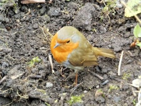
Bleasdale Circle with Fairsnape and Parlick looming above.

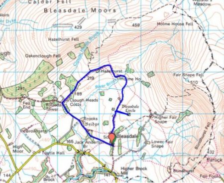
Another of my winter favourites. This circuit is mainly on lanes and good tracks but takes one right into the hills. I’ve written about it many times but today I have come across some interesting new facts.

For a start, Bleasdale School dating from 1850 where I park is now closed. It soldiered on since the Millenium with about a dozen pupils from the surrounding farms but when the number dropped to two or three its fate was inevitable.

Up the lane, the Parish Hall is heated using a wood pellet boiler with a wind turbine to generate electricity, forward-thinking for a small community. Further on is the uniquely named St. Eadmer Church.

The lane then heads into the hills past a few farms. A footpath diverts to visit Bronze Age Bleasdale Circle. Originally two circles of wooden posts with ditches and a central burial chamber. The wooden posts of the inner circle have been replaced by concrete posts but still are evocative of the site. There is the usual speculation as to the uses of these circles and their positioning. Burial urns from the site have been on view at the Harris Museum in Preston.  The whole site has been planted with a circle of trees which are visible from many parts of Bleasdale. The outer circle, obstructed by the trees, was possibly from an earlier Neolithic era. Ritual sites are often reused over the ages. I visited it today and got my feet very wet in the approach fields.

themodernantiquarian.com

Further into Bleasdale, there is a section of boggy ground before the next farm tracks which come in from the west, like crossing a watershed. All around are good views of the surrounding hills. As well as the Curlew and Lapwings a small flock of Pied Wagtails entertain me flitting along the wall tops. I’m now approaching the properties of the Bleasdale Estate. The estate is now run as partly agricultural and partly a shooting concern but I’ve just unearthed some of its history.

In the C19th a Mr Garnett lived in nearby Bleasdale Tower, he was an agricultural reformer and philanthropist and in 1857 founded The North Lancashire Reformatory School constructed on the estate. It catered for over a hundred boys who worked on the land and in trades such as tailoring and shoemaking as well as receiving an education

“In November 1857, a few weeks after its opening, three boys escaped from the institution due to the fence wall having not been completed. They were all apprehended in Preston the same evening and returned to the Reformatory.”

“Of the 51 discharges for 1865 thirty-three were doing well, twelve convicted, one dead and five missing”

As I walked down the lane today I crossed over Clough Head Brook on a substantial stone bridge which apparently was constructed by the boys. Stonemasons’ tools are depicted on the parapet.

The lane goes through the original school buildings which are now used as cottages and workhouses for the estate. The school enlarged over the years and eventually closed in 1905. A map from 1893 shows the school

In a wall on the corner is a King Geoge V post box [1910 -36]

Taking the shorter route on tarmac brought me past Brooks Farm where an arched ‘packhorse’ bridge is visible over the River Brock. Despite its appearance, it was never built for horses with steep steps at either end. It is not on a known packhorse trail and didn’t appear on maps till 1893. It has been suggested that the bridge was built to provide access from Bleasdale Tower to Bleasdale Church, I wonder if those reform boys built it.

In the wood nearby are some new, not particularly attractive, chalet type holiday lets, a sign of the estate diversifying.

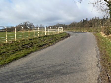
My way back to the school was enclosed by smart beech hedging for which the estate is renowned.

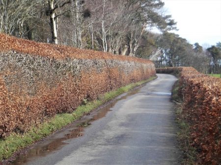
I took this photo of the Bleasdale hills on my way home, St. Eadmer’s church is right of centre.*****

*****

This walk was completed two days ago and since then advice about walking and climbing during the coronavirus emergency has been sensibly updated. As I’m in the vulnerable group I’m taking heed. We are all responsible for limiting the seriousness of the situation in the next few months.

BMC Advice.  18/03/2020

  • People need access to the countryside for their health – both mental and physical.
  • Follow the most current NHS advice regarding health and distancing. Currently Public Health England’s advice is: “you can go for a walk outdoors if you stay more than 2 metres from others.”
  • Consider your means of travel and distance – close to home is best and, despite the environmental impact, it’s better to be in personal cars than public transport at the moment.
  • Stick to familiar areas and low-risk activities.
  • Reduce your risk. Be very aware that medical and rescue services and facilities are going to be extremely stretched and overwhelmed. It would be socially irresponsible to be taking risks at this time that could place an additional burden on medical and emergency services.
  • Do not assume that Mountain Rescue will be available. There is a real possibility of reduced or even no cover for rescue in some areas as this develops.


CURLEW COUNTRY, STANLEY FELL.

I’ve set the bar high with trying to keep my feet dry in the wet weather we’ve had. But I’ve found another walk which takes me on lanes into the rough fell country between Chipping Vale and the Bowland Fells, namely Stanley Fell. There is nothing more evocative of this wild habitat at this time of year than the cries of the Curlew and the Lapwing. They were both present in voice and vision whilst in the gale-force winds unable to be photographed, but you all know what they look like.

Walking up the road there was little traffic. More hens out on the loose than cars. White railings were used on corners of country lanes to improve visibility. I turned off into the Leagram Estate and passed the dell where snowdrops were in profusion last week. The next farm has a surfeit of sheep and lambs under roof all looking very healthy, they breed BlueFaced Leicesters here..

I love these tree roots.

Lanes continue to more remote farms many now upmarket residences. Ahead is proud Parlick. I’m getting into the hills.

I come out onto a road where Saddle End Farm is up the hill, I’m not going that way today but buy a half dozen free-range eggs at the end of their lane. I wonder if anyone is up on Fairsnape in this gale.

Saddle End Farm.

Turning right I follow the last of the tarmac which leads to the remotest farm, Burnslack. A culverted stream runs alongside. I recall coming here with my young children and exploring through the concrete pipes, admittedly not in flood conditions, to emerge higher up the stream – nine out of ten for child cruelty.

The way in…

A bridleway heads into the hills where the curlew are calling. On the way, a gate hangs on across the track, not even baler twine will save this one.

There is an old ford over a lively stream, I often feel an urge to follow these waters up to their hidden source, an endless task. This is remote country, not a coronavirus insight. As I come over the watershed there are the limestone knolls of Dinkling ahead and in the background Birkett Fell and Warrington Fell. Expansive uplifting scenery.

The track drops down to Lickhurst Farm, now a complex of stone residential conversions. Below is a little valley, a motorist parked up asks me where the Forest of Bowland is – I tell him he is in it and direct him through Little Bowland to the Inn at Whitewell. An old limekiln is passed…

… and a little further a low bridge over a stream, this used to be a ford and alongside is the original stone clapper bridge. This is unique in being a single stone over 15ft long. [Now guarded by wooden handrails.] All evidence of a way of living long past.

The road goes on by that often photographed and isolated red phonebox.

I have friends living in the Higher Greystoneley farm buildings so a cup of tea is very welcome. From there another stoney bridleway drops down to a ford, with wooden footbridge, and through limestone country to my car. I drive home in the gale knowing my feet remained dry and looking forward to poaching one of those farm eggs for lunch.

*****

.

A GLOOMY LONGRIDGE FELL.

With all this wet weather I’ve become obsessive about keeping my feet dry and out of the mud so today I walk up Longridge Fell on forest tracks and return on the road. I’m still restricted to a few hours in the day so It suits me to do another short walk whilst the weather is dry. I’m following a popular dog walking trail, I can tell that from all those black plastic bags by the track but I don’t want to spoil my walk by becoming angry so I ignore them. Every time you come up here there has been more tree felling changing the nature of the walks. They seem to plant new saplings amongst the debris of the felling without worrying about the remaining stumps.

There is evidence of the strength of the recent storms with trees casually uprooted. Onwards and upwards I go, I have no intention of getting my trainers dirty by going to the summit, I’m content getting some exercise on the tracks. I detour to a viewpoint towards the Bowland Fells which I always enjoy. These are size 12s if you need any.

Back on the main track, it starts to descend in sweeping curves, would be great on a mountain bike, towards Kemple End with Pendle In the distance. On reaching the road all I have to do is turn right and follow it back to my car less than two miles away. I normally avoid roads when there are alternative paths but this quiet highway turns out to be pleasantly undulating with views to the south. It certainly serves the purpose of keeping my shoes clean and dry. Halfway along is a small stream, Brownslow Brook,  coming off Longridge Fell which appears to be culverted into a water collecting plant, I’ve never noticed it when driving this road and I can find no clue to its function. I’m back home for lunch thinking it was probably me rather than the fell that was gloomy.

*****

RAPTOR PERSECUTON.

The Hen Harrier is an iconic bird of the Bowland  Fells, one I saw regularly in Croasdale but now, rare indeed. It even features as a logo on the roadsigns for the Forest of Bowland. [Some wit has suggested replacing it with a grouse.}

On the Radio Lancashire news yesterday there was an appeal to the public regarding the shooting of a Hen Harrier on the Bowland Fells between Slaidburn and Clapham. The unusual nature of this appeal from the police is that the shooting took place in October 2019. I wondered how seriously the police take these criminal acts if they are only now asking for information.

A little research comes up with the following post. As well as questioning the police response to this incident they publish a depressing list of about 30 Hen Harriers believed to have been illegally killed since 2018.

No further comment. Please read.

https://raptorpersecutionscotland.wordpress.com/2020/03/05/hen-harrier-shot-in-north-yorkshire-police-appeal-for-info-5-months-later/

THE EAST COLNE WAY.

A walk through the green lungs of Colne.

I picked up this leaflet at the cafe on Beacon Fell the other day, it looked interesting. Despite my friend Sir Hugh stating  ” The ones I am not enamoured by are where some local authority has connected a lot of inferior paths around the edges of crop fields with no particular objective other than perhaps encircling their borough or domain and claiming this as The Whatevershire Way”  to discover relatively new territory I was prepared to give The East Colne Way a chance.

I’ve driven along the A6068 Nelson to Keighley road many times on my way to walks in the Bronte Country and climbs on Earl Crag and familiar landmarks which I would visit today. This another of my short walks I’ve been doing recently to fit in with the weather and other commitments. I turn off the road to a lakeside carpark at Ball Grove Nature Reserve. This was the site of an C18th water-powered cotton mill which became in 1860 Sagar’s Tannery, the largest in Europe. Production ceased in 1970 and the buildings were demolished all but the present-day cafe.

I strolled alongside the lodges, now nature reserves, and Colne Water to a weir with a fish ladder.

An unofficial scramble brought me onto the road opposite the old cottage Hospital bequeathed by the Hartley family which has been converted into retirement accommodation.


Hartley Hospital.

Along the road are the Hartley Almshouses donated again by the Hartley family, yes those of jam fame. Talking to two residents one was very positive the other concerned about damp.

I cut up through some rough fields with ancient boundary walls and stiles, I’m surprised to find a waymarker for my walk, these continue to guide me around the circuit. 

I pass the workers cottages at Bents without a photo and press on up Skipton road to pass the Georgian  Heyroyd House, Apparently round the back are walled gardens.

More stone stiles led across fields to a lane alongside Colne Golf Course. A clapper bridge has had rails added to it – health and safety? It opened onto a lane that looked more like a stream.

The rocky ridge visible ahead is Noyna Hill, a real ‘green lung’ of Colne.

Farm lanes followed and I was soon crossing the causeway at Foulridge Upper Reservoir. The sun was quite warm and I lingered admiring the views over to Pendle Hill, Blacko Tower and round to Noyna and the Great Edge all Pendle walking areas par excellence.

The large gated property, Lower Clough owned by the Barnsfield Construction Co, had some impressive, well-guarded grounds. An open area The Rough is what remains of Lob Common, worryingly new housing seems to be creeping up the hill. Curlew are calling as I walk through. I come out onto a surprising lane lined on one side by handloom weavers’ cottages, several three-storied. Down at the roundabout is the old Turnpike House which I’ve driven past without realising its existence. Also on the lane is Lidgett Hall dated 1749. This delightful Conservation Area backs onto the open countryside where the housing development is occurring – so much for town planning.

Turnpike House.


Lidgett Hall.


Another open field heads towards a church with the hills above Wycoller in the background. I finish the day with a coffee in the lakeside cafe at Ball Grove Mill. This turned out to be a 5mile walk through beautiful northern countryside giving an insight into the past life of this area on the edge of industrial Colne. The only sour note is the lack of protection from developers to land unchanged from the C17th. 

*****


THE SINGING RINGING TREE.

There aren’t many trees on the bleak Pennine Moors above Burnley but in 2006 one was planted on Crown Point south of the town. Architects Tonkin and Liu designed a structure composed of metal pipes which, as well as being a stunning visual feature, creates a musical noise from the wind playing through the pipes. The Burnley Way [which I walked in 2017] predates it and thus avoids it which is a shame, some minor re-routing would easily include this notable landmark.

JD mentioned he had never visited the ‘Tree’,  not many of our friends have either. A walk was hatched to include this site, we procrastinated on several occasions during the stormy weather but today we set forth with a better forecast.  Several suggested walks start off from Townley Hall but parking is charged there so we, or rather I, decide to park up on a street in nearby Walk Mill.

We pick our way up various bridleways, parts of The Burnley Way and The Pennine Bridleway, onto Deerplay Moor. I’m not saying it was all easy going, the farmyards were a mudbath but we got through. Views to our left are down towards the Cliviger Gorge where road and railway head for the delights of Todmorden. We come across a memorial stone to Mary Townley who was instrumental in establishing long-distance routes in the Pennines for horse riders. In 1986 she road from Hexham to Ashbourne to draw attention to the poor state of England’s bridleways. Today these improved bridleways probably benefit mountain bikers rather than those on horseback.

The quotation The air of heaven is that which blows between a horse’s ears.” is, in fact, an Arabian Proverb.

We had a bit of a depressing section on a road where there was evidence of fly-tipping every few hundred metres. I just cannot understand this blatant antisocial behaviour.

The ‘tree’ had been out of sight most of the walk but at last on Crown Point, we left the road on the well-trodden path across to it. Unfortunately, a Union Jack has been stuck into it diminishing the visual impact of the fine installation. There was only a light breeze today so the tubes were only murmuring. We speculated on what sounds were produced in the recent gales, there will probably be something on youtube. 

Crown Point is a fine viewpoint in itself with Burnley below and a backdrop of Pendle Hill. There had been some patches of old snow as we walked up and there was a definite white rim to Pendle Hill. Easy walking took us off the hill directly back to Walk Mill and its historical past,

*****


A QUICK WALK AROUND BEACON FELL.

Longridge Fell is usually my quick fix hill for some fresh air and views but the tracks up onto it will be muddy, to say the least. I choose instead Beacon Fell with its well-made tracks,  it is no further to drive. Longridge Fell Is reputedly the most southerly named fell so Beacon Fell must be the second being only one mile further north. I can ascend both of them easily from my house for longer walks but this afternoon I only have an hour or so spare.

As I arrive in the quarry car park a pair of Roe Deer stand and look at me but quickly disappear when I open the car door. I thought I had a photo of the male but nothing shows up.

I walk briskly in a circle around the hill on familiar paths. I’ve never come to terms with the waymarking here.

There are a few dog walkers out, the cafe is strangely quiet. Everywhere seems green and moss-covered, a sign of a mild and very wet winter.

As I’ve mentioned on previous visits up here storms have taken their toll on some areas of the forest with a lot of tree felling taking place to tidy things up. Perhaps this is a blessing in disguise as the fell has a more open feel to it now and some of the new plantings are of native deciduous trees. Also, wood carvers have been busy creating new pieces.  I add a few more to my collection. There are ‘Green Men’ carved on some trees… … but today I find something a bit different – a ‘Green Woman’ or has someone taken a fancy to one of the lady volunteer rangers?

An obligatory visit to the trig point and I notice that the views to Fairsnape and Parlick are becoming obscured by growing firs – time for another storm?

I’m back at the car within the hour feeling much refreshed.

DRY FEET TO PILLING.

Knott End to Pilling.

On display next to a caravan site in Pilling is a restored Hudswell 0-6-0 steam engine similar to the ones used on the old Knott End To Garstang Railway, it has been painted in their livery and renamed the Pilling Pig. This abandoned railway was built to link the agricultural areas of Wyre with the mainline. It had a chequered history.

The whistle of these engines squealed like a pig – hence the name Pilling Pig.

The cafe where I park this afternoon is on the site of the old railway terminus at Knott End, next to the ferry over to Fleetwood. This was a favourite place of the painter LS Lowry and several of his paintings include the ferry slipway. To celebrate this association a statue, by local designer Tom Elliot, has recently been installed.

Jetty at Knott End. L S Lowry. 1957.

The above diversions link my walk this afternoon from Knott End to Pilling.

Storms are continuing and fields are flooded so I opt for the raised sea wall to keep my feet dry today, I’m confident enough to walk in trainers. Talking to a resident of the seafront he explains the sea is either way out of sight or breaking over the promenade. Recent sea defences have prevented flooding which is good news.

At the moment the tide is coming in. There are views across to a vague Black Combe and a clearer Morecambe Power Station.

The portion of the foreshore still visible is thronged with wading birds, I forgot my binoculars and the wind is too strong to take zoom shots with my little camera so their species will remain a mystery.

That is apart from this Little Egret which seem to becoming more and more common on our shores and estuaries.

The landside of the path is uninspiring with a few houses, caravan sites and flooded fields. At one point I pass a fenced off reedy area, a tractor is just leaving it and my query of the driver reveals that it is a Mallard breeding area with 40,000 birds who are elsewhere at present. I do not feel it is the moment to discuss my opinion of breeding birds for the shooting fraternity.

All afternoon the Bowland Hills filled the skyline to the east, what a contrast to the flat coastal area. Nearly all the other walkers on the wall have dogs.

The sea wall continues but seems to be fenced off [I’m tempted], the Lancashire Coastal path I’ve been following continues down Fluke Hall Lane into Pilling alongside a delightful period Junior School. Across the way, The Golden Ball inn looks ominously quiet. I’ve time on my hands but decide to explore the village rather than prop up the bar. Dam Lane takes me to a bridge over Pilling Water with a nearby desirable converted windmill. Another raised sea wall goes north to join the embankment I had previously considered following. Signs state that this should not be used from December to April but without a reason given.

I next look around the Parish Church, St. John the Baptist, yet another designed by the Lancaster firm Paley & Austin and built in 1887. There is fine stained glass in the east and west windows. I didn’t realise this church replaced an earlier C18th chapel which is just down the lane, Apparently, it still has the original wooden galleries. One to visit on another occasion.

The only other visitor attraction is Pilling Pottery which was closed. I sat in a cold and windy bus shelter hoping my bus back to Knott End would arrive on time before I froze.  It did –  and my feet were still dry!

I messed up my navigation driving home and ended up on one of the worst roads in Lancashire through Eagland Hill – very narrow, lined by flooded ditches, twisting with sudden right-angled bends,  undulating from subsidence on the marsh and the tarmac breaking up in many places. With Storm Jorge in full swing, I was relieved to reach Nateby and the A6.

*****

ROADS TO NOWHERE PART 2. HACKING FERRY.

I’ve found another one. This time on the West Pennine Moors 1:25000 Map 287 sheet over the hill in the Ribble Valley. I was pleased with my little expedition on a dead-end track to the Hodder the other day, so I started looking further afield and immediately came up with another obvious ‘road to nowhere’ It leaves the road at Mitton Hall and leads down a strange little peninsular to where the Ribble and the Calder join. I’d been on the opposite bank near Hacking Hall three years ago and even took a photo of this peninsular point. 

It was near here that Hacking ferry operated up until the 1950s, so perhaps this footpath linked with the ferry.

Time to put on the boots again.

I thought the best place to safely park was in the grounds of Mitton Hall Hotel, I find a place as far as possible from the hall, there are few cars about, and slink off along the road. An alley leads into fields, and I’m immediately confronted with a flooded stream I dare not jump across. I find a way round to Little Mitton Farm and wander through their yards without any problem and without seeing a soul. Stiles give access to fields which take me into Mitton Wood, an obvious pheasant breeding area, all I see are half a dozen roe deer the pheasants having been shot.

I’m walking along a ridge between the Ribble on my right and the Calder on my left, at its end I drop down to a stile into a riverside meadow. The field narrows as I proceed just above the flood line.  This is quite a dramatic situation with the two rivers roaring by. At its end, I can see Hacking Hall on the left bank of the Calder and the Hacking Boathouse on the right bank of the Ribble.

Near here in the past was the Hacking Ferry mentioned above. It is documented that the ferry ran on Sundays to enable people to attend church, but I wonder which – Old Langho or Great Mitton. There are historical photographs of the Hacking Ferry which was popular in the late C19th and early C20th.  One could probably request where you wanted to be dropped off. The last ferry boat is said to be preserved in Clitheroe Museum, I have yet to visit it.  (Fo more information  – The long lost ferry boat that evokes happy memories of rural Lancashire – Museum Crush)

The Ribble Way follows the north bank of the Ribble, and it was always planned to construct a bridge across at the confluence of the rivers. Stood at the end of the peninsular I wonder about where the bridge would have connected up these footpaths. I later find online the designs for an innovative bridge linking all three by Flint Neill civic engineers. This was back in 2003 before funding was withdrawn for such projects. An amazing looking three-way arch footbridge, with 43.5m legs and a high arch at the confluence of the Ribble and Calder rivers. What a shame it was never constructed, The rivers were running high with tree trunks whizzing along.  A few walkers were braving the winds on the Ribble Way. How many people come down to this spot I’m standing on? A kingfisher flashes past as I retrace my steps upstream.

I find my way back into the woods as the gale blows through the trees, creaking and groaning, hoping none will come crashing down – this is Tolkien’s Middle Earth after all.

.

At Mitton Hall Hotel the car park was completely full of wedding guests, I felt rather out of place in my full waterproofs.

ON THE ROAD TO NOWHERE.

I’m content to sit and peruse OS maps on a cold, wet and windy day.  In front of me is the 1:25000 Forest of Bowland and Ribblesdale [OL41]. I’m not too keen on double-sided maps, especially in a howling gale when you always need the reverse side. but the west side covers my local hills. Unfortunately, Longridge lies off the edge of this sheet and another, the Blackpool and Preston [Explorer 285].  It just makes the edge of Explorer 287, West Pennine Moors. All very difficult for a days walk.

Back to OL41 what takes my notice just now is a “dead-end”  public right of way path leaving the Chaigley Road opposite Walker Fold and heading to the River Hodder – ‘a road to nowhere’

Curiosity aroused I wondered about its origins, the fact that it ends at the river suggests there may have been a ford here in times past, but there is no path marked on the other bank. Does anybody ever walk this dead-end path? maybe fishermen and presumably the local farmers. Does it even exist on the ground? Lancashire C.C. still shows it as a right of way on their website. On an older map, I see that the trees at its end are named Limekiln Wood, could there have been a lime kiln at the end of the track?

The sun is coming out this afternoon, time to explore and see where I get to.

I was apprehensive as I left the road at Walker Fold. The footpath sign was hidden in the foliage, the lane looked private and there was a lot of water flowing everywhere. I have to admit to carrying wire cutters in my pocket. The first ‘obstacle’ would be the grounds of the properties on the lane but I needn’t have worried  – there was a stile with an arrow pointing me across their land via more stiles and a little bridge. Soon I was in open fields with well-constructed and maintained stiles showing the way, many of these appeared relatively new. In fact, this was country walking as it should be, the sign of a responsible landowner?  The only downside was the rain saturated fields courtesy of our recent storms.  A footbridge crossed a lively stream and the path weaved through plantations. Ahead on the horizon was the familiar outline of the Bowland Fells.

Once over a farm access road, my gravelled track started to descend towards the Hodder which could be heard before it was seen. Sheep looked at me as though they rarely saw anybody, mind you they always look like that. And then there I was stood next to the raging river with as I’d guessed a lime kiln built into the hillside. Along the banks were the limestone crags, the raison d’etre of the kiln and the original path. There was another clue as to the path’s continued existence – a small fishing hut and stiles giving access to the river. Lancashire Fly Fishing Association maintain this stretch.

What an idyllic spot on a summers day but at the moment the river is in flood mode and roaring down the valley. I was in a different world down here, the hidden Hodder, and for half an hour or so I watched in awe.

Downstream.


Upstream.

Mission completed I retraced my steps up the hill and used the road back to Walker Fold to avoid the worst of the soggy fields. A couple of things to note in this little hamlet of less than a dozen houses. It won the Lancashire’s best kept hamlet competition in 1994 and 2006 and boasts an old School/Chapel with links to The Latter-day Saints movement back in the mid C19th.

Now let’s have a closer look at those maps again…