Tag Archives: Lancashire

ON THE ROAD TO NOWHERE.

I’m content to sit and peruse OS maps on a cold, wet and windy day.  In front of me is the 1:25000 Forest of Bowland and Ribblesdale [OL41]. I’m not too keen on double-sided maps, especially in a howling gale when you always need the reverse side. but the west side covers my local hills. Unfortunately, Longridge lies off the edge of this sheet and another, the Blackpool and Preston [Explorer 285].  It just makes the edge of Explorer 287, West Pennine Moors. All very difficult for a days walk.

Back to OL41 what takes my notice just now is a “dead-end”  public right of way path leaving the Chaigley Road opposite Walker Fold and heading to the River Hodder – ‘a road to nowhere’

Curiosity aroused I wondered about its origins, the fact that it ends at the river suggests there may have been a ford here in times past, but there is no path marked on the other bank. Does anybody ever walk this dead-end path? maybe fishermen and presumably the local farmers. Does it even exist on the ground? Lancashire C.C. still shows it as a right of way on their website. On an older map, I see that the trees at its end are named Limekiln Wood, could there have been a lime kiln at the end of the track?

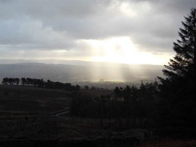
The sun is coming out this afternoon, time to explore and see where I get to.

I was apprehensive as I left the road at Walker Fold. The footpath sign was hidden in the foliage, the lane looked private and there was a lot of water flowing everywhere. I have to admit to carrying wire cutters in my pocket. The first ‘obstacle’ would be the grounds of the properties on the lane but I needn’t have worried  – there was a stile with an arrow pointing me across their land via more stiles and a little bridge. Soon I was in open fields with well-constructed and maintained stiles showing the way, many of these appeared relatively new. In fact, this was country walking as it should be, the sign of a responsible landowner?  The only downside was the rain saturated fields courtesy of our recent storms.  A footbridge crossed a lively stream and the path weaved through plantations. Ahead on the horizon was the familiar outline of the Bowland Fells.

Once over a farm access road, my gravelled track started to descend towards the Hodder which could be heard before it was seen. Sheep looked at me as though they rarely saw anybody, mind you they always look like that. And then there I was stood next to the raging river with as I’d guessed a lime kiln built into the hillside. Along the banks were the limestone crags, the raison d’etre of the kiln and the original path. There was another clue as to the path’s continued existence – a small fishing hut and stiles giving access to the river. Lancashire Fly Fishing Association maintain this stretch.

What an idyllic spot on a summers day but at the moment the river is in flood mode and roaring down the valley. I was in a different world down here, the hidden Hodder, and for half an hour or so I watched in awe.

Downstream.


Upstream.

Mission completed I retraced my steps up the hill and used the road back to Walker Fold to avoid the worst of the soggy fields. A couple of things to note in this little hamlet of less than a dozen houses. It won the Lancashire’s best kept hamlet competition in 1994 and 2006 and boasts an old School/Chapel with links to The Latter-day Saints movement back in the mid C19th.

Now let’s have a closer look at those maps again…


SALE WHEEL – THE RIBBLE POST-FLOOD.

We’ve had two weekends of storms, Ciara and Dennis, with serious flooding in parts. The River Ribble hit the headlines with yet more flooding of Ribchester. I didn’t venture out last weekend when local roads were impassible but today things had settled a little and Storm Dennis was petering out. I always regret not going down to the river whilst it is in flood, the usual excuse is bad weather.

Not today. I parked up at Marles Wood; there were some dodgy looking cars and individuals around, so I photographed their plates for evidence later if my car had been trashed. Putting that aside I strolled off down the path to the Ribble where it cuts through a sandstone ridge and into an open stretch of water. This is the Sale Wheel. There seems to be a fault line in the rocks as the water flows through into an enormous whirlpool and then a right-angled bend to the river. Today the force of the flow took the turbulent waters off down the valley with little regard to the pool. Last week the flow would have taken the river onto the fields at the bend.

I was satisfied with what I saw and set off upriver. There was evidence of the height of the water last week when most of today’s path would have been impassable. Dog walkers, a common sight on this stretch, were keeping their pets on a close lead – any splashing about in the river would lead to tragedy.

As you approach the Dinkley footbridge there is normally a bit of a shingle beach and shallows in the river – not today, the mighty Ribble just flowed past.

Compare with a summer’s day…

The new bridge is substantial but, I wonder about the stability of the abutments on this side of the river; there already seems to have been some damage and undermining of them as the flow of the river curves into the bank..

Across the bridge, I picked up the Ribble Way markers for the stretch back to Ribchester Bridge. The way leaves the river through fields, today very boggy, and up to an elevated area where there are superb views back up the Ribble Valley to Pendle Hill and Dinkley.

I took an illicit detour into the woods to view the Sales Wheel from this side, and the river was equally exciting. Where the rocks dip, erosion shows the bands of gritstone alternating with mudstones. Both were laid down in a massive delta, the grits when the water was moving fast and deep and the mudstones when slow and shallow. Here, the strata have been faulted to almost vertical.

The way onwards through the woods, normally a pleasant path,  was difficult because of all the debris from the floods. The couple I met coming the other way were from Merseyside, having a couple of days in Hurst Green, The Shireburn Arms, exploring this part of the Ribble Valley – tomorrow, The Tolkien Trail.

The Ribble rolled on……to Ribchester Bridge.

I took the lane back on the south side of the river. The day had stayed fine, the wind only increasing towards the end of the afternoon, the last of Dennis.

Seeing the power of a river close up and imagining it a few metres higher, one has to have every sympathy with those whose houses have been inundated these last two storms. Unfortunately it appears that these floods will become the norm, whether from climate change or our mismanagement of our immediate environment. I look out at fields opposite me which are completely saturated; they are due for housing development, so where will the water go then? I think I know, better order some sandbags.

*****

LONGRIDGE RESERVOIRS.

I’ve had enough of splodging through waterlogged fields so today for my short walk I was happy to keep mainly to tracks and roads. Why not walk around the reservoirs in Longridge? There are basically seven, Dilworth Upper and Lower, Spade Mill 1 and 2, and Alston 1, 2, 3.

Preston originally had water from springs in the Alston area and a reservoir was built in Grimsargh in 1835. The first Upper Dilworth reservoir was built about the same time for water from Longridge Fell. As demand increased water was collected from the Bowland Fells and conducted to Longridge and its Alston [now no3] reservoir completed in 1842. Demand from Preston increased and the next to be constructed was Spade Mill [no 1], along with The Black Bull inn, see later as Corporation Arms. Some years of drought, remember them? lead to the purchase of Alston College on the edge of the village. Demolition of the college allowed a second Alston Reservoir [no 2] to be constructed in 1899. A second smaller Dilworth [lower] was opened in 1906. In the 1930s the aqueducts from Bowland were improved with the drilling of two tunnels, one out at Whitewell and the other through Longridge Fell from Jenkinson’s Farm in Thornley to Spade Mill Reservoir. A third large Alston [now no 1] was constructed about the same time.   The last of the Longridge Reservoirs to be built was Spade Mill [no 2] coming into use in the late 1950s.

That’s a lot of water.

Dilworth Upper.    1835.     24 million gallons.

Alston No 3.           1842.     86 million gallons.

Spade Mill No 1.   1862.    198 million gallons.

Alston No 2.           1899.    183 million gallons.

Dilworth Lower.     1906.        7 million gallons.

Alston No 1.            1931.    259 million gallons.

Spade Mill No 2.     1956.    212 million gallons.

The reservoirs have been under several different authorities, Preston Corporation, North West Water and now United Utilities.

Right, back to my walk, I parked up in upper Longridge and set off around the small Dilworth Reservoirs. immediately the strong Victorian stone architecture was visible …

Just above is the upper reservoir which is often a haven for waterbirds, Great Crested Grebes nested last year.  The lower reservoir has been decommissioned and I was under the impression that the upper was polluted from nitrate wash-off from the fell. Despite this, it is a popular angling spot.

Upper Dilworth with Beacon Fell in the background.

A footpath goes from here through an old quarry, Greenbank, now a housing estate. At the lower side of the quarry is a lake once a fishing spot for local youths. Above the houses is the well-known climbing venue Craig Y Longridge. From up here, there are views across the two Spade Mill Reservoirs and on to Alston. The lane I take goes past the WrittenStone which I’ve previously detailed here.

Walking along the main road I was outside the walls of the Spade Mill no 1 as I arrived at The Corporation Arms, the only inn uniquely owned by a waterboard.

Just past here I detoured up a bridleway to get a better view of Spade Mill No 2 the most modern of the reservoirs. Next, I was walking down to the Alston Reservoirs, both officially off track. The lane continues below the reservoirs and what was No 3 but now is managed as a nature reserve. There are hides to view the water and margins. With my naked eye today I saw very little, it was cold and windy.

Apart from the conversion of No 3 to a wildlife site, the reservoirs have a very sterile environment. There is some restricted fishing but one wonders why they couldn’t be opened up for some watersports. An interesting walk of about 6 miles on a breezy but dry afternoon.

Next up is storm Dennis – the menace.

NICKY NOOK. Calm before the storm.

As I arrived at the summit of Nicky Nook, a modest 215m, the wind was strong enough to make photography difficult. It was mid-afternoon, I hadn’t set off very early and Storm Ciara is on her way.  This hill, I don’t know the reason for its name, is just across the fields from my walk to Calder Vale the other day.

There were crowds coming up Nicky Nook from Scorton, or rather from cars parked everywhere on the lanes leading up to the fell, all to save half a mile of uphill. Traffic chaos prevailed. If this was the lakes these lanes would have double yellow lines to preserve peace and quiet for the local residents. I’d come a different way creeping round the back. A little lane off the main road gave sensible parking and I set off walking by St. Peter’s Church, the one with the pointy spire seen from the motorway heading north.

[Squire Peter Ormrod, who had made his money from the  Lancashire cotton mills, there was one in Scorton, built  Wyresdale Park in the mid-C19th. He died in 1875 and his brother James built the Church in his memory. All the family are buried here.  The architects were Paley and Austin of Lancaster, who designed many beautiful local churches. Interestingly the cut sandstone came from Longridge quarries.]

The road leading south from Scorton is narrow and busy and as a Millenium project a raised pathway was constructed to avoid the traffic. You feel rather hemmed in but I made good use of it today between the road and the River Wyre. Soon I was crossing fields with the prominent westerly stone tower of Nicky Nook visible above.

Footbridges crossed both the rail line and motorway giving close up views of the speeding trains, now in a new livery, and the traffic on the motorway with that well-known view of the spire of St. Peters.

A vague path crossed more damp fields to the complex of houses at Throstle Nest. Signage was poor and one had the feeling of being unwelcome close to the expensive properties. Even the stile leading to the road was low key and not signed from the highway. Normally most paths in the Wyre District are well marked. Feeling grumpy I was distracted and set off along the lane in the wrong direction!

After correcting my mistake I arrived at the entrance to Grizedale, a deep wooded valley coming out of the Bowland Fells. I made good progress up the well-used track, most people were coming the other way having already descended from Nicky Nook. A seat in the valley took my attention – one wonders about the stories behind these inscriptions.

Rest awhile and think of Vicki – drinking coke and looking pretty. 1990-2004.

The fell above was cloaked with rhododendrons which seemed at odds with the birch and oak forest I was walking through. A reservoir was reached, Grizedale Reservoir built in the mid – C19th along with others nearby to serve the Fylde with water from the Bowland Hills.

The steep climbing started up steps and a made-up path, it is a very popular hill. On the way up a tower was seen to the left and I went to investigate, probably for surveying when the reservoirs were constructed.

As I said the wind was already troublesome on the top and I didn’t linger long. Since I was last here Lancashire Red Roses have been stencilled on the trig point. Views to the Bowland Fells, towards the Lakes and Morecambe Bay were a little hazy. The most obvious visible features were man-made – Morecambe power Station, the motorway and several large caravan parks.

A wide track set off down towards Scorton but my attention was taken by another tower off to the west. It turned out to be a memorial to Queen Victoria’s Jubilee and gave a birds-eye view of Scorton. Its makeshift pole has gone askew.

Back on the main track, the hordes were returning to their parked cars. I slid off onto a delightful little path in the woods above Tithe Barn Brook taking me back to my parked car.

A pleasant two and a half hours’ exercise. Storm Ciara came and went but little did I realise the storm to come, Covid-19.

*****

CALDER VALE.

Calder Vale is a hidden village tucked away from the world to the east of the Bowland Fells. Quakers Jonathan & Richard Jackson founded Calder Vale realising the River Calder would provide water power and in 1835 the Lappet mill was built to spin cotton. At the same time, they provided for their workers and their families by building houses on site. A further mill was built downstream for weaving the fabrics. The waste from these mills was transported to Oakenclough further up the Calder where the same family had established a paper mill. Most of the mills have long since closed but the Lappet mill has survived by specialising in the production of Arab head shawls!  Those red or blue and white shemaghs for protection from the sun as well as windblown sand.   Time for a revisit.

I waited this morning for the mist to disperse, and I waited. By 12am I decided to set off hoping the sun would appear as promised. I am not far away as the crow flies but the lanes in this area are a maze. Eventually, I found a parking place by Sandholme Bridge on the Calder. I wanted to walk into Calder Vale from above to fully appreciate its position. The quiet lane rose up above the river heading towards the Bowland Hills [which were in the cloud]. I was directed off the lane towards Cobble Hay Farm, a working farm that also hosts a popular café and gardens. Guess what, it has been closed all winter but is reopening tomorrow, so no coffee today. The original farm is dated 1681.

Once through the farm, one is onto open pastureland which today was a quagmire, and I was concerned about becoming stuck as my boots sank further and further into the mud. Up above a couple of buzzards were wheeling around and crying. I approached the next farm cautiously, thinking there may be dogs at loose, but I was greeted by this friendly face.

I’m now on the edge of the Bleasdale Fells [Bowland], there used to be a pub up here, The Moorcock, now closed and a private house. I was aiming for the little St John’s Church,1863, the parish church high above the village.  It was closed today but apparently has some fine stained-glass. Next to it is the little village school serving a wider area than just Calder Vale, I wonder how many children walk up from the valley each morning.

Reversing their route through the woods I met up with the River Calder down below. A pleasant stretch alongside the lively water brought me to a weir where water was taken off to a large millpond which previously supplied the Lappet mill. The mill is no longer water-powered but it is interesting to follow the original leats.

Now deep in the valley, the first row of Calder Vale workers’ cottages are passed and how delightful they look today but car parking is obviously a modern-day problem. [heading photo]

The Lappet Mill is massive and the sounds of weaving can be heard outside. Let’s hope the demand for headscarves continues.

Just past the mill is an old farmhouse, a sheepdog rushes out to greet me. The farmer appeared, and we had a long chat on all things rural, meanwhile, the dog rounded up all the hens in the yard – ‘showing off’ said the farmer.

More cottages were reached over a footbridge. Alongside the river, there was very little sign of the lower mill, only a few stones and water channels here and there.

The track climbed out of the valley and crossed fields to a country lane. A man was practising with a parapente on an easy slope, he never got off the ground.

Once on the road, I walked quickly back to the car with the weak sun in the west and the rumble from the motorway becoming intrusive. I stopped to buy half a dozen farm eggs towards my tea.

*****

VIRTUAL CLIMBING.

Last week I was tracing virtual walks on OS maps, the guides arrived and are promising. Today, still with the knee strapped, I’m following routes up rock faces, again in my mind. A few jolts to my memory of friends and climbs shared.

Going back 30 – 40 years I was climbing as often as possible – maybe 4 or 5 times each week. You are bound to become good and in my own world, I did.  My regular climbing partners back then became my best friends, where are they now?

I’m not writing here of those who have faded into retirement, all great friends whom I still see.

But these three are missed the most, routes and companions come to mind in vivid detail.

Tony, the gentle giant from the Yorkshire coal mines, Off we went to California on an adventure of our lives only to find our English ropes too short for Tuolumne granite. Replenished we tackled some great climbs in Yosemite. RIP

Pete, the haunted personality, with a reach far further than mine. A Cornish holiday stands out and that ‘one more route’ on Gimmer Crag which had him in deep trouble back at home. RIP

Doreen, the elegant mover and faithful belayer and now deeply into suffering Alzheimer’s.  I’ ve just managed a 100 hundred piece jigsaw with her today and that was far harder than her last route, Jean Jeanie.

I must fish out some old slides of these climbers and scan them. So many memories and tales to be told.

For a start a grainy shot, from my study wall, of the Ist ascent of Pinocchio at Craig y Longridge, Sept 1989, Doreen belaying.

OUT OF LONGRIDGE.

I wake to bright sunshine but take some time and coffee to get going. The health of two of my best friends is deteriorating; one with heart and kidney failure, the other with cruel dementia. I was talking to them both yesterday and it struck me that it doesn’t seem long since we were out climbing and walking together. So you have caught me in a pensive mood, not at all that  ‘happy new year’ feeling. I should have arranged a walk with one of my other friends for today – to ‘get me out of it’ but now it’s too late, I’ll just have to go myself which is not good for those introspective thoughts but I usually find the combination of sunshine and exercise clears my mind.

I’ve had enough of muddy fields recently so I’m happy to walk on roads for some much-needed exercise after the season’s excesses. Living where I do I’m lucky to be able to walk out my door and ascend a fell, in fact, the most southerly named fell in Britain, Longridge Fell. I’ve done it hundreds of times before. No matter there is always something new or worthwhile.  To start I spot a half dozen partridges running across the road in front of me, is it a covey or a bevy? And then a buzzard on the telegraph wires. After that, I seem to run out of wildlife sitings. Longridge is surrounded by water in the form of reservoirs and I pass the smallest one on my way out of town. Then I walk below the golf course which looks in fine fettle for winter but it must be a struggle in the wind, it is so exposed to the elements.

The road, the old Clitheroe road which kept to high ground, goes up and down towards the New Drop Inn. Few cars pass me. Turning the corner here I am walking in the footsteps of the Romans, this was their way from Ribchester to Carlisle.  The highest point on the road is reached near Cardwell House and looking back Pendle Hill looks as proud as ever. I bump into an old friend taking his dog for some exercise up the fell, we chat about all things local. This is his favourite hill and he’ll have his ashes scattered nearby. Coincidentally this is also one of my favourite viewpoints and my ashes will be here too, I told you I was in a morbid mood.  Years ago I asked a local artist, A Lord, to paint me the view from here over Chipping Vale with the Fairsnape/Totridge ridge in the background.

This painting is one of my prized possessions with its links to a past friend and to this great viewpoint. In the painting are the white iron railings that were a common sight on road corners around here to improve visibility for the motorist. They are slowly disappearing, I’ve always thought they should be listed as unique structures.

The weather was changing, dark rain clouds circling around the hills with the occasional rainbow over Chipping. Soon it was all downhill back to Longridge. Five miles with five hundred feet of ascent in one and a half hours. That’s how you clear your mind. Oh, and I found three good golf balls to boot.

*****

A LANCASHIRE MONASTIC WAY. 11. Carnforth to Arnside.

                                                                   Silverdale.

This is easy – just walk around the coast with not a single religious site to visit but a myriad of paths in an ‘Area of Outstanding Natural Beauty’

From Carnforth station, a steam train was just getting ready to head off on a Santa Special. I tramped dingy streets to find a back road leading to a bridge over the River Keer. Familiar ground led up onto the higher road above Warton Sands. The terrifying main limestone quarry was just catching the early sunlight. The views across the marshes were obscured by trees. At the end of the road is the familiar chimney at Crag Foot, all that remains of a pump house used to drain Leighton Moss.

I head across the marshes towards Jenny Brown’s Point where there is another preserved chimney, this one from a short-lived C18 copper smelting endeavour. Flocks of geese wheel above me. Across the bay, Morecambe power station appears to be in the sea.

Despite the tide being out, walking along the muddy beach doesn’t seem attractive, so I take the little lane above until I can go onto NT land at Jack Scout Cove. From up here, I can see the remains of ‘Walduck’s Wall’, an attempt to reclaim an area of land between the point and Carnforth in the mid-C19.  This disappeared beneath the sands before re-emerging in 1975 as the channels changed. I used to climb on a small limestone cliff, with perfect, water-washed handholds and fossils, hereabouts, but trying to identify it from above is difficult. I do, however, come across a limekiln which was restored some years ago, and I remember it being fired up to celebrate the event.

Back on the lane, I pass Lindeth Tower, originally built as a summer house and now available to rent as holiday accommodation.

This area holds  many memories for me; camping at Gibraltar Farm, dodging the tides at Jack Scout’s Cove, bouldering at Woodwell, cosy teas in The Wolf House Gallery and buying unusual plants from the brothers at the nursery along the road.

In Silverdale, I take the grassy path across The Lotts shown to me by Sir Hugh on a previous occasion. This takes you straight to The Cove, an enchanting place next to the sea with a prominent cave on one side. NT volunteers were out cutting back vegetation. Back on lanes, I cross the boundary from Lancashire into Cumbria. I presume my guide refers to the ‘old’ Lancashire as it heads towards Furness.

Holgate’s caravan park is massive but well laid out and maintained. I stop for a snack in a wrought-iron shelter celebrating the life of Frank William Holgate, 1941 – 2015.

A good track leads to the tottering pile of Arnside Tower, a C15 Pele tower built because of the threat posed by Border Reivers.

Looming above was Arnside Knott, another NT estate. Having climbed it many times, today I had the luxury of following woodland paths around its base. Even from this lower elevation, there were good views across the Kent estuary to Grange and Humphrey Head. I picked up a path across Red Hills Pasture and into the woods, where I became disorientated until popping out next to the cemetery. Before you knew it, I was seated in Sir Hugh’s sanctuary with a strong cup of coffee. He even gave me a lift back to Carnforth so I didn’t make it to the promenade and station in Arnside.

*****

A LANCASHIRE MONASTIC WAY. 10. Lancaster to Carnforth.

                                                                 Morecambe Bay.

Another day snatched from Winter.

In his guide, John Covey follows the Lancaster Canal from Lancaster to Carnforth. That is a route I’ve walked often in the past so I decide after exploring Lancaster to follow the Lancashire Coastal Way instead.

Covey details a Lancaster Friary,  a Dominican community of preachers. [1260 until dissolution] There is no trace of any building now.

He also mentions St. Leonards Hospital established in the C12 as a leper hospital later having a church and chaplain for the poor. It closed in 1470 and all trace has gone.

Gardiner’s Hospital was established as an almshouse in St. Mary’s Gate near the castle around 1485. These almshouses were rebuilt in 1792, eventually to be sold in 1938 and the site built upon. To replace them, four almshouses were built in Queen Street. At last, I had something to seek out and find. On the way, I came across the Friends Meeting House, a Quaker building dating back to the Friends Meeting House, a Quaker building from 1708. That set me musing in this election week. would the Quakers be the ‘Greens’ of religion? what of the rest?  RC’s – Tories, CofE – Labour, Methodists – Lib Dem. We will know our fate tomorrow.

Also in central Lancaster, I already knew of the Penny Almshouses. William Penny, several times mayor, gave funds in 1715 to build 12 small houses and a chapel for ‘poor indigent ancient men and women’. They received a house, an allowance, a suit of clothes and the services of a chaplain. The plaque over the entrance records Penny’s generosity and warns in Latin, ‘profanos hinc abesse’ – those of ill-repute should keep away.  Next door,  the Assembly Rooms were built in 1759; income from events helped support the almshouses.

On my way up past the castle, I noticed another property – ‘served as a dispensary providing health care for the poor, 1785 -1833’  Lancaster has been very charitable in the past.

My object of climbing up here was to visit Lancaster Priory Church. A Benedictine priory was founded around 1094 on the elevated site, about the same time as the castle was being established on an old Roman Fort. The remains of the priory are under the Church, which was built in the C15. Becoming a parish church it avoided destruction in the Dissolution. Inside are the celebrated carved choir stalls with their misericords from 1340, two sets of impressive organ pipes, along with some beautiful stained glass.  From up on the hill, the site of the Roman Fort, a path led down and passed close to the Roman Baths.

All I had to do now was walk a dozen miles to Carnforth.

The Millennium Bridge was right in front of me, and I crossed the Lune to pick up a cycle path all the way to Morecambe. The views across to St George’s Quay had the Priory high above and a crooked house squashed in below. There was not much to see on this straight route, so I made good progress and was suddenly in front of the Midland Hotel. No, I didn’t go in for coffee. I saved that till a little later at the Lighthouse Cafe, a community cafe with a comprehensive menu. Whilst I ate toasted teacake [homage to my good friend Tony] I gazed out at Eric Morecambe bringing me some sunshine on the prom. Unfortunately, when I emerged from the cafe, the rain came down and had me scurrying for my waterproofs, which once donned, of course, the rain stopped for the day.

The promenade went on for what seemed like forever, with a few installations to distract one. Suddenly, I was free of roads and walking on the shoreline. Stoney and muddy in equal proportions. The tide was out, but following all the recent rainfall, the marshes were very boggy.  Views across Morecambe Bay were obviously extensive b,ut the background hills came and went. Ahead was the prominent but diminutive Arnside Knott.

At Red Bank Farm, busy with visitors to the cafe, I came across The Praying Shell statue carved in limestone above the sands where 23 Chinese cockle pickers died in 2004.   Artist Anthony Padgett has said a link may be made to that tragedy, but the idea was conceived before.          “Its symbolism is intended to parallel humanity’s openness to a larger dimension and the way cockle shells open as the tide comes in.” Another couple of miles of marshland with lots of channel hopping where there was no distinct path, probably underwater at high tide. I climbed to higher ground in one or two places. I must admit to being uneasy in tidal areas. The Keer Channel was a muddy mess. I finally hit solid ground on the little road running alongside the Keer and realised I’d been here before with Sir Hugh on our Way Of The Crow Walk between Longridge and Arnside. That was a very wet day 2 years ago.

I had a brief encounter with Carnforth Station before catching my train.

*****

A LANCASHIRE MONASTIC WAY. 9. Cockerham to Lancaster.

                                                         Lancashire Coastal Way.

It is strange weather – one day of wind and rain, the next bright sunshine and then more rain. I take my chances on a sunny day. I’ve moved on to the northern part of Lancashire’s Monastic Way by John Convey, I may think about a link-up from Sawley at a later date. It is a clear morning with a chilly wind coming off the sea as I walk down the lane to  St. Michael’s Church, an Anglican Parish Church in Cockerham. Of course, it is closed when I arrive. The oldest part is the C16 tower. The body of the church was rebuilt by the Lancaster architects Austin and Paley.  who were responsible for much church architecture from the mid 19th century. Cockerham Priory from the C13 was situated hereabouts, but there are no remains from when it was dissolved in 1477.

Soon, I was on The Lancashire Coastal Way following flood defences, surrounded by low-tide marshes around the coast to visit Cockersand Abbey. The obvious remains are the C13 Octagonal Chapter House with a few other bits of walls from the Abbey Church. There had been a hospital on the site, which was dissolved in 1539. The land was subsequently acquired by the Daltons from Thurnham Hall, and the Chapter House used as a mausoleum, hence its preservation today. It is a bleak spot for an Abbey.

Out in the Lune estuary is the Plover Scar Lighthouse, also known as the Abbey Lighthouse, an active 19th-century lighthouse now fully automated. The last time I was along here, the lighthouse was being repaired following a collision with a commercial vessel. Nearby on the coast is the original lighthouse keeper’s cottage. The lighthouse can be reached at low tide, and in the past, the keeper would have had to attend to the paraffin lamps.

After Crook Farm, I followed what had been Marsh Lane, which disappeared under flood water at one point. Wet socks resulted.

But soon I was seated outside the friendly Glasson Cafe enjoying a coffee and pasty.

The marina was quiet at this time of year; I joined the Glasson Branch canal, which, when it was completed in 1825,  joined the Lancaster Canal near Galgate. Then, in 1883, came the railway to link to Lancaster, it was on this disused line I would continue the walk. But first, I had a look at Christ Church alongside the canal. This Anglican Parish Church was designed by Edmund Sharpe, who became involved with the Lancaster firm of Austin and Paley mentioned above. Originally built in 1840, but added to in the 20th century. I walked in to find that the west gallery has been converted into an accessible coffee/reading room. The stained glass in the east window was impressive, designed by Joseph Fisher [1979] of the Lancaster firm  Shrigley and Hunt

Returning to the Railway track, I crossed the River Condor and headed north, easy walking with views across the Lune estuary. To my right were the grounds of Ashton Hall, now a golf course. I could not see the hall, which was established in the C14, a tower apparently is from that date. The hall has had many owners, but in 1884 was sold to the wealthy linoleum manufacturer, James Williamson, who, when he was knighted, took the title Lord Ashton. With reference to today, he arranged to have a halt built on the railway line I’m walking on. After his second wife’s death, he had the Ashton Memorial built in Williamson Park, an elevated site seen from afar and later today.

River Condor.

Ashton Hall Golf Course.

Along the line, the hedges were loaded with red berries, no wonder lots of birds were about, Redwings and Fieldfares. A solar farm has been built near Stodday, they must have more sunshine here than the rest of Lancashire. The climb away from the line up to Aldcliffe was steeper than expected. I was now heading directly into Lancaster along the Lancaster Canal, a route I’ve used before.

Today, I had time to leave the canal and take a look at the nearby Lancaster Cathedral. In 1791, when the Roman Catholic Relief Act was passed,  local Catholics built a mission in Dalton Square. When a larger church was needed, local architect Paley designed this church for the present site, which was consecrated in 1859 and became a cathedral in 1924. The tower and spire are 240ft high, making it visible throughout the city. The interior was impressive, but with too many fussy side chapels. Some of the stained glass was by Shrigley and Hunt, mentioned at Glasson. Unfortunately, I found a lot of the information preachy; I can appreciate the stunning architecture without being religious.Time to catch my bus.

                    Lancaster with the Ashton Memorial, Cathedral and Town Hall.

*****

ANOTHER VISIT TO ROEBURNDALE.

I ‘discovered’ Roeburndale whilst walking Wainwright’s Way between Dunsop Bridge and Hornby a couple of months ago. The route I was following dropped into the valley and climbed out just as quickly. I thought there must be a better way to explore this valley of natural woodlands. Research on the web showed some permissive paths but even those didn’t link up completely. When Sir Hugh was wanting to complete his WW trail in the area I was only too keen to revisit and investigate paths in the valley. The plan was to leave one car at Hornby, drive to the foot of Salter Fell and walk back down the hidden valley. Simple. Come the day and we struggle to negotiate the ice on the narrow steep road, expert driving by Sir Hugh. Shaken after skidding up that steep hill we consider what to do. I became nervous about returning up the hill in my car later in the day and having two cars stuck. We decided unanimously to get the hell out of here as soon as possible, so Sir Hugh in first gear retreats. The skid marks on the road were still there later in the day – good decision. The road is much steeper than the picture suggests.

Now parked up in Wray our option is to walk up Roeburndale and somehow [all a bit vague] find a circular route back. Wray is a quiet village of stone cottages which hit the headlines in August 1967 when the Rivers Roeburn and Hindburn flooded causing loss of properties, bridges and livestock but thankfully no villagers. The way out of the village is by Kitten Bridge over the River Roeburn, this was the way for workers going to Wray Mill [wool and silk] now converted into accommodation. Looking back over the village Ingleborough was prominent.

We picked up a track leaving the road at a small building and followed it into the woods quite high above the river. The path was intermittent and hidden beneath all the Autumn leaves.  In about a third of a mile, it started descending steeply and remains of wooden steps in places suggesting we were on track. Once down level with the river, there was some boulder hopping to be done and lots of fallen trees to get around. A truly hidden valley.

A meadow was then traversed to the bridge I had crossed before in the middle of those apple orchards. This time we followed the permissive footpath signs along the valley. The vague path climbed away from the river ending at a belvedere overlooking the river. Onwards we went, picking up the odd waymark and guessing, intelligently, where the path would go. We spotted a diversion to the wire bridge across the river and went to explore the other side. The bridge was exciting – slippery, creaking and swaying.   A camping barn was marked on the map and we found it after one false alarm. We gained access from the outer stairs which led into the bunk room, all very cosy. Down a ladder, we were in the kitchen with all you would need for a night’s stay. I wonder who owns/runs this place. Once back over the bridge……we pick up the permissive path once more as it contours high in the valley just in the edge of the woods. The day was passing, there was no sign of a thaw and we didn’t have a plan. My thought of returning along the fells to the east was slipping away with the daylight.  We decided to follow blindly the permissive path and cross the river by the bridge Sir Hugh had found the other day. Lots of undulations in the trees before we came out into open fields and started dropping down to the river. A muddy track led us to ‘Sir Hugh’s bridge’  which was sturdier than the last one. The path seemed to go away from the river so we made the decision to climb up to the road which would be our quickest way back to Wray. [It would have only been another quarter of a mile to Barkin Bridge and thus completing a stretch of Wainwright’s Way wholly in this delightful wooded valley.]                                                                                                                                             In parts the road was an ice rink and as I said our tyre marks were still visible from this morning. This otherwise pleasant stroll down the lanes was enhanced by views to Ingleborough, Whernside, the Howgills and the Lakeland tops.

They were just starting carol singing when we arrived in Wray.

*****

A LANCASHIRE MONASTIC WAY. 8. Whalley to Sawley.

                                                                         Sawley Abbey.

Time we visited an Abbey or two.

But first, a visit to Taste Buds Cafe for a second breakfast and coffee, what a great takeaway. Good coffee and tasty bakery.

Fortified, I wander through the graveyard of St Mary & All Saints, built on the site of an 8th-century church and a later Norman (circa 1100) church. The present church building dates from around 1200, with the tower being added in 1440. Inside are apparently ancient pews, some of which are from the Abbey. Despite several visits, I’ve been unable to see inside. The Saxon Crosses in the graveyard I’ve pictured before.

I go through the Eastern gate of Whalley Abbey to look at the remains of one of the largest monastic sites in the north. A Cistercian order started here in 1296 and was still expanding in the 15th century. There was a church, monastic lodgings and an infirmary. After the dissolution, it passed into private hands and most was demolished, so only low walls remain. The larger walls were part of the monks quarters. A manor house was built on the site and today is used as a religious centre. An image from their website gives an idea of the layout. The last Abbot, John Paslew was executed for his part in the Pilgrimage of Grace, an uprising against Henry VIII actions. The emblem of the Abbey – Three Fishes – crops up a lot in the locality.

I leave the village via the vast west gate and out under the railway into the countryside along the Calder River.

Dog walkers were out in force using footpaths that were new to me. I walked around the site of Calderstones Hospital, an institution for people with learning disabilities. Most of the site has been demolished and redeveloped for housing. Out the other side of the complex, I’m into semi-frozen muddy fields on the line of a Roman Road to Skipton, and somewhere there is a base to a medieval cross. I spent some time looking for it, backwards and forwards. Frustrated, I carry on only to stumble into the large, unmissable stone nowhere near its OS mapped site.

From this open ground I have good views of Pendle to the east… … and to the north, Longridge Fell. In this shot can be seen the domes of Stonyhurst College and, closer at hand in Mitton, the old hall and the C13 All Hallows Church. It is a shame this church isn’t visited on this walk as it is full of interest, including medieval woodwork from Sawley Abbey and memorials to the local Shireburn family, dating from the late 16th century.

Now back on the Ribble Way, I start meeting lots of dog walkers from Clitheroe. I come round a corner to see a lady with binoculars studying a tree, and she points out the kingfisher to me. Wonderful. Off it flies only for me to come across again shortly in some reeds upriver. It’s times like these that I wish I had a better camera.

The walk by the river around Clitheroe was very familiar to me, and I made good progress as the sun gradually lowered in the sky. The works at West Bradford are all too familiar. Near Grindleton, the path climbs up onto the road from where there are good views of misty Pendle.

Ahead is the bridge over the Ribble at Sawley.

I reach the  Sawley Abbey grounds with half an hour’s daylight remaining.

Another Cistercian monastery, founded in 1146, it bordered onto the lands of Whalley Monastery, and there are records of quarrels over fishing rights on the River Ribble. After dissolution, the abbot William Trafford tried to resurrect the abbey under the Pilgrimage of Grace. This failed and Trafford was hanged at Lancaster in March 1537, and the abbey immediately plundered of its valuables. Over the years, stone from the monastery was used in local buildings. On the ground, there is little left of the church, but remnants of the refectory and a grand fireplace are visible. Outside the site, earthworks connected to the monastery can be seen in the surrounding fields. I’ve now finished the first half of A Lancashire Monastic Way, from Upholland to Sawley and thoroughly enjoyed the new paths and history I’ve encountered. The next half is from Cockerham Abbey to Furness Abbey;  I’m wondering whether to devise my own walking link between the two?

*****

A LANCASHIRE MONASTIC WAY. 7. Ribchester to Whalley.

                                                                         Whalley Arches.

I’m away early on a clear frosty morning as I continue my way linking Lancashire’s religious sites.

Walking out of Ribchester, I divert up a little lane leading to some interesting treasures. Firstly, on the left is St. Peter and St. Paul, a barn church, dating back to around 1789. At that time, it was still illegal for Catholics to have public places of worship. Therefore, it was built to appear like a barn. The church was considerably enlarged in 1877. The inside is very plain, but there are some outstanding new stained glass windows designed by Deborah Lowe and executed by Pendle Stained Glass in memory of the Walmsley family.  One celebrates the life of St. Margaret Clitherow, the York martyr whose remains are reputed to have been possibly buried in the nearby Stydd church of St. Saviour. [See below]  Margaret was crushed to death in York at Easter, and the window references Stydd, York’s shambles and minster as well as the spring season and her reputed last words: “Jesus have mercy on me.” Another window celebrates the region’s history and landscape, depicting a scene from the River Ribble. Fishes, a kingfisher, sheep and a horse are included in the scene, which shows wildflowers and a dandelion clock, suggesting the passage of time.

In the graveyard, I came across a type of ‘triptych’ gravestone of the Pratchett family. Who were they?

Across the way is a delightful small building, the Stydd Almshouses.  Built by the Shireburn family in 1728 to house the poor people of the parish. Quite unique. Even the well is listed.

Further up the lane in a field is St. Saviour’s Chapel, established in C12 – 13. Associated with it was a ‘monastic hospital’ of the Knights Hospitaliers providing accommodation and aid to pilgrims and the needy. There is no sign of the hospice, but the chapel remains, having undergone several modifications.

Fortunately, it was open this morning, so I was able to view its simple interior. The original studded south door gains entry. The most obvious initial feature above the altar is a graceful C13 window reflected in the design of the oak chairs. The Norman north doorway is blocked, but the original wooden door remains in place against it. There is a stone coffin of unknown origin and several tomb slabs on the floor of the Sanctuary. A lavishly engraved C14 one, Sir Adam and Lady de Clitheroe; a straight cross, Father Walter Vavasour 1740;  a simple cross, possibly St. Margaret Clitherow, the martyr mentioned above. High on the west wall is an old entrance from another building and possibly a gallery similar to the one in St. Michael’s Church in Much Hoole I visited a few days ago. Outside, the northern door has Norman dog-toothed carving. To complete the picture, there is also a medieval cross base in the grounds.

Back on the road, it was a short walk to Ribchester bridge over the Ribble. Here, the Ribble Way continues as a track past farms to come alongside the river. At one of the houses, I was accosted by a weather-beaten gardener and given a lesson in how to save the world through nature. The path alongside the river was very familiar to me. A couple of herons took flight, and there were cormorants this far inland. Ahead, Pendle Hill looked resplendent above the valley, and the new Dinkley Bridge shone white.

Once over the bridge, I followed lanes, on the line of a Roman Road.  Over to the left was Longridge Fell, and the green domes of Stonyhurst College could just be made out. Its origins began abroad as a Jesuit School when Catholic education was banned in England. The local Shireburn family owned the C13 hall, and their descendants donated it to the Jesuits in 1794. It has flourished as an international Catholic School to this day.

This was the reverse of a day on Wainwright’s Way a couple of months ago, so I knew my way across the fields and up past those modern static caravans to reach the Church of St. Leonard at Old Langho.

I popped into the Black Bull Inn next door for the keys to the church. Like St. Saviours at Stydd, this is a simple building. Interestingly, it was built around 1557 using stones from the dissolved Abbey at Whalley. a number of carved stones are in the exterior walls. Inside the pews have carved ends from the late C17 with initials of their benefactors. Fragments of medieval stained glass have been incorporated into the north chancel windows. The tiles in the sanctuary are Victorian.

The graveyard was extended in the early 20th century to serve the nearby Brockhall Hospital. There is a single mass grave commemorating 600 patients, but that is another story.

More lanes brought me into Whalley, where I crossed the River Calder on Old Sol’s bridge alongside the brick arches of the railway viaduct. The light was starting to fade as I came through the massive, vaulted west gate of the Abbey. It was too late to visit the Abbey, that can wait until tomorrow morning. The nearby Parish Church always seems to be locked when I pass by; it apparently has stalls removed from the Abbey. I was able to see the Saxon crosses in the graveyard before catching my bus home.

*****

A LANCASHIRE MONASTIC WAY. 6. Red Scar to Ribchester.

                                                                      Roman Ribchester.

The bus drops me off at the Preston Crematorium, and I stroll down the remembrance avenue. The land to the right is industrial units on the site of the former Courtaulds Mill, which produced Rayon. This was a large operation on the edge of Preston with its own power plant and railway, a branch of the Preston-Longridge line. Over 2000 jobs were lost when it closed in 1979. Its prominent chimneys and cooling towers dominated the landscape until demolition in 1983, when lots of the population of Longridge went to view the explosive event.

Lancashire Evening Post.

I was now on the top of Red Scar, a steep escarpment dropping to a horseshoe bend of the Ribble. I’ve joined the Ribble Way, which goes eastwards high above the river,  glimpsed through the trees. Worryingly, I start to notice ‘Footpath Closed’ signs, but continue to see what the problem is and not wanting an unnecessary detour. I climb over barriers. The path drops to cross Tun Brook, and there have been landslides damaging the footbridge and its abutments. I can’t drop into the stream bed as the mud is too steep and unstable, but can I cross the bridge?  The stepped way to it is impossible, but with a little sidetracking, I reach the edge of the bridge, which has been further damaged by a falling tree. Tentatively, I make my way onto the creaking structure, thinking that if it fails, nobody will find me here. I’m relieved once across the other side. Satisfying but foolish.

Moving on after I’d climbed out of the ravine, I was on country lanes and in wet fields well above the Ribble. Distant views were rather dull. Coming the other way, you wouldn’t have been too pleased by this sign…

Hereabouts was a Roman road marked on the map, but not much evidence on the ground. I passed close to Alston Hall and the Observatory previously attached to it. There was plenty of evidence of horses ruining the fields.

A succession of ups and downs finally brought me out onto Hothersall Lane, which drops dramatically down to the River Ribble near the outdoor centre.

A curiosity I am aware of is the ‘Hothersall Boggart’. A buried stone head was found on the land and placed in the fork of the tree, leading to tales of fairies and boggarts. Heads are found in this area and were often placed on buildings to ward off evil spirits. [see more in the Roman Museum to follow]

Along the lane is Hothersall Hall rebuilt in 1856 in the Gothic style and looking resplendent today. I sat on a nearby stone to eat a sandwich which set off a dog barking in the garden; a few crusts seemed to please him.

Across the river was Osbaldeston Hall, another place with a long ancestry.

.

I was alongside the river now, which today was meandering slowly, but this area is prone to flooding, and Ribchester often makes the headlines on those occasions.

Ribchester is famous for Bremetennacum, the Roman fort strategically situated on the banks of the river at a crossroads of several important routes. Not only was there a cavalry fort, but also a vicus, a village community surrounding it. It was time to visit the Roman Museum…

The phrase ‘good things come in small packages’ applies to this excellent little museum. The Roman history of the area is comprehensively explained, and artefacts displayed and interpreted well. One of the first findings [1796] of Roman occupation was by a schoolboy in a ditch – The Townley Hoard – now displayed in the British Museum. As part of this hoard is a well-preserved helmet, and there is a replica on display here.  Of great interest are the more mundane items on display – combs, leather shoes, brooches, glassware, slingshot balls, etc. Oh, and there are some more stone heads.

Replica Roman Helmet.

Tombstone of Asturian Cavalryman.

Well worth a visit.

Behind the museum are the excavations of a Roman granary and nearer the river, a Roman Bath House [heading photo]. How much more must be lying beneath the present-day Ribchester?

Granary.

Built on a site close to the Roman Fort is the C13 St. Wilfrid’s church, stones from the fort most likely being used in its construction.

Inside, the Dutton Chapel contains a small C14 wall painting of St. Christopher and some medieval coloured glass pieces in one of the windows. There is a recorded mass burial from the Black Death in the C14 when the chapel was added.  Black Death wiped out a large percentage of the population, and following it, there were not enough peasants to work the land, the feudal system fell apart, and it became more economical in Lancashire to graze the fields with sheep. Hence, the wool trade gave way to the cotton trade, where spinning and weaving skills existed, leading in turn to mills and urban industrialisation.

In the porch is a beautifully carved tombstone of obvious antiquity from a grave of a Knight of St. John of Jerusalem, an order once based at St. Saviour, Stydd – but that’s for tomorrow’s walk.

One of the gravestones in the churchyard has the following inscription…

Here lieth the body of
Thos. Greenwod who
died May 24 1776
In ye 52 year of his age
Honest, industrious
seeming still content
Nor did repine(?) at what
he underwent
His transient life was 
with hard labour fill’d
And working in a
makle(?)pit was kill’d.

The nature of Thomas’ death seems clear – he died in an accident, probably a marl pit, of which there are many in the area. They were dug to obtain lime-rich mud, which was used to improve the land; most are now small ponds.

Nearby is a C17 sandstone sundial…

Church Street is lined with weavers’ cottages, many of them listed but spoiled with all the parked cars. The White Bull, an iconic inn with its porch supported by columns possibly from a temple to Minerva,  a place of worship in Roman times.  The attached sandstone mounting block is cut into three steps.

Further on is the Black Bull inn and nearby my bus stop where I was preparing for a half an hour wait when up pulled one of my neighbours with the offer of a lift home, a good end to a satisfying day.

*****

A LANCASHIRE MONASTIC WAY. 5. Preston to Ladyewell.

Guild Wheel and Ribble Way.

I was back in Preston bus station, and a short walk, including Winkley Square, had me in Avenham Park. It wasn’t supposed to rain, but I was donning waterproofs under the old railway bridge before setting off along what was mainly the Preston Guild Wheel shared with The Ribble Way. The weather remained dull and damp all day.

The 21-mile Guild Wheel cycle and walking path  [National Cycle Route 622] was opened in 2012 as one of the projects of that year’s Preston Guild. Established by royal charter in 1179, the Preston Guild of Traders was initially held every few years on an irregular basis but has taken place every 20 years since 1542, except 1942 when it was cancelled due to World War II, resuming in 1952. It circles the city of Preston, mainly on off-road trails, and is very popular with cyclists.

In the park, a group of Cromwell’s soldiers were preparing to re-enact the Battle of Preston.

I normally cycle this route, so it was a different experience on foot, but I was able to make fast progress. I was soon on the banks of the river opposite Cuerdale Hall, the site of the Cuerdale Hoard discovery in 1840. The hoard was a vast collection of Viking silver coins and jewellery now displayed in the British Museum.

Cuerdale Hall

The trail became busier once it entered the Brockholes Nature Reserve, a large wetland area. I didn’t have binoculars with me, so there was no lingering. The steep track up into Red Scar Woods was easier without having to push a bike. Leaving the Ribble Way, the Guild Wheel goes through the grounds of Preston Crematorium.  The diversion to Ladyewell Shrine involved roads and tracks very close to the motorway, so the traffic noise was ever-present. The lane leading up to the shrine is thought to have been a pilgrim route for centuries and continues to be so. The present Ladyewell House incorporates a chapel from 1685, which was used until St. Mary’s Church was built up the road in 1793. [I have photos of my children in a nativity play in the present-day church when they attended the neighbouring Fernyhalgh infant school, now closed.] Our Lady’s Well remains the object of pilgrimages to this day, pressing a button serves you with water from the well. There is also an ancient cross base here amongst the modern Catholic shrines and religious tat. I’m not sure why the Ladyewell Shrine has become so popular as a pilgrimage destination.

*****

A LANCASHIRE MONASTIC WAY. 4. Longton to Preston.

The Ribble Way.

I’m late setting off today, and my bus gets me into Longton just before 12, but I only have to walk back to Preston on The Ribble Way. As I arrive on the route, having walked down Marsh Lane, another walker appears and asks about the whereabouts of the RW. I know where he went wrong, as the signage was very poor. We walk down the lane to join the riverside way, it turns out he is in training for a long Camino route next year. To be honest, there is not a lot of interest in this flat, featureless stretch, so we fall into step and conversation. Having cycled the Camino from Le Puy-en-Velay in France to Santiago de Compostela, I took great interest in his plans and pledged to support his chosen charity. Today, he was planning to pick up the Guild Wheel at the docks, but hadn’t realised there was no bridge across the Ribble until Penwortham – thus giving him some extra training. Along the way, I pointed out on the far bank the dug out Ribble Link enabling a link-up from the Lancaster Canal to Leeds-Liverpool Canal and the rest of the system. I’m not sure how often it is used, as you need a pilot boat to take you down the Ribble to enter the Douglas. The entrance to Preston Docks was passed without a bridge. The tide was out and the river did not look its best.

The Ribble Link.

Preston Docks entrance.

Past Penwortham Golf Club, we entered a parklike space which was the former Penwortham Power Plant, demolished in the 80s. I realised I needed to leave the river to seek out the monastic sites above, Penwortham Priory, so we went our separate ways, and I wished him the best with his efforts. I climbed out into Castle Walk, there was a Norman ‘motte and bailey castle’ hereabouts until 1232. The castle was built to control a ford across this important waterway. I marched around Castle Walk until directly below the present church, but the developers had defended it well there was no way through. Backtracking, I encountered several ‘Priory’ road names all related to a Benedictine priory and subsequent mansion situated here until demolition in 1920. All is now new housing. [One of my climbing friends lived in Priory Crescent until recently; he has made a good choice by moving to France.]

No way through.

Around the corner was St. Mary’s Church, which I approached down an avenue of trees. Nearby was the base of a stone cross for which I can find no information. The prominent Lych Gate was surprisingly locked, a less-than-welcome sight; nonetheless, I worked my way around into the extensive graveyard. Somewhere is the tomb of John Horrocks, the noted C18 Preston cotton manufacturer.  The church itself dates back to the 15th century. To the north of the church is the mound on which the Castle was probably built.

The river was just below, but the defences, present-day wire fences, were impregnable until I found a chink in the armour and escaped onto the river embankment, thus saving a long walk out on the busy road. Now back on the Ribble  Way, I was aiming to cross the river on the ‘old Penwortham bridge’; there are newer bridges downstream. A cobbled way took me over to the north bank.  Alongside the old bridge are the remains of a dismantled railway bridge; this was the former West Lancashire Railway from Southport leading to its terminus at the bottom of Fishergate Hill. Nearby, one of the cottages is named Ferry House, suggesting the presence of a ferry before the bridges were constructed. Ahead was the present mainline rail bridge, and seen beyond it, the redundant East Lancashire Railway bridge previously bringing trains from Blackburn into platforms alongside  Butler Street goods yard, which is now The Fishergate Shopping Centre. So that is three rail bridges entering Preston from the south.

The two C19 parks, Miller and Avenham, offer a wonderful recreational facility on the edge of central Preston and have been smartened up in recent years. I managed to get lost in roadworks on East Cliff and reappeared in the rail depot alongside the station. I’d only been walking for 3 hours.

Miller Park.                                                                                                 

Within Preston, Convey mentions three other religious sites which are not visited, saving me some legwork.

Preston Friary, in what is now Marsh Lane,  was established in 1260. Friars were different from monastic orders in that they spent their time in the local community preaching and engaging in missionary work.

Tulketh Priory, a Cistercian abbey established in 1124, but moved to Furness soon after. Tulketh Hall was built on the site and demolished in 1960 to make way for housing.

St. Mary Magdalen’s hospital for lepers,1177, run by monks. Its chapel became a site of pilgrimage until the Dissolution. St. Walburge’s church was built on the site. This church is famous for its 309-foot steeple, seen from all the surrounding areas. The notorious Fred Dibnah’s last job was working on this steeple back in 2004.

A distant view of St. Walburge’s steeple.

*****

A LANCASHIRE MONASTIC WAY. 3. Rufford to Longton.

                                                           Marshy Lancashire.

I’m back on the rattly but reliable train to Rufford, along with the regulars, and I find out that a token is still used between Midge Hall and Rufford on the single-track section, failsafe.

I’m straight onto the canal, the branch of the Leeds Liverpool destined to merge with the River Douglas and the Ribble Estuary, from where The Ribble Link connects to the Lancaster Canal. Here it is wide and stately, reminding me of the Canal du Midi. The old hall of Rufford is just visible through the trees, started in 1530 and associated with the Hesketh family for generations. Now in the hands of the NT and only open weekends in winter. The canal here traverses low-lying drained lands, made more sombre by today’s low, weak sunlight. There is no one else about and only a few boats are moored up. With no distractions, I soon reach Sollom Bridge, where the towpath seems to run out and the canal has wilder rushy borders. I come inland to the small hamlet of Sollom, on a corner is a medieval cross base. The cottages and barns here have been sensitively restored, and it is an oasis of calm just off the hectic A59. Whilst I was walking down the next track, my camera somehow switched onto an ‘artistic’ mode.I was able to disable it by the time I reached St. Mary’s Church. I have driven past here many times on the main road and wondered about its origins and unusual architecture. There had been a chapel on this site from early C16, but the present church was erected in 1719, the bricks would have been handmade. It was extended in 1824 when the rotunda was added to the tower. Apparently, the interior has many original items, box pews and oil lamps, but it was closed today and I could only peep through the keyhole. The church is no longer in use and is administered by the Churches Conservation Trust.

Through the keyhole.

I crossed the canal and river, soon to be united on their way into the Ribble, and noticed this old warehouse.

Hidden in the trees to the right is Bank Hall.  C17 Jacobean, under restoration. All I could see was a possible gate lodge.

Up the road is Bank Hall Windmill, built in 1741, now converted into private living accommodation.

On a busy junction, again hidden in the trees, is Carr House. It is commonly thought that Jeremiah Horrocks made his observation of the transit of Venus across the sun, on 24 Nov. 1639, while living at Carr House. More of this soon.

Glad to leave the busy A59 onto a little lane leading towards Much Hoole. Ahead was another interesting church, St. Michael, an early C17 building. The church has connections to the above Jeremiah Horrocks, who may have been a curate there at the time of his important astronomical observations. There is a marble tablet commemorating him as well as some of the stained glass windows. The church has a two-decker oak pulpit and a long upper gallery.

I next crossed boggy fields towards the River Douglas. There were some new ‘No Public Right of Way’ notices on the public footpath, which annoyed me and have been reported to the appropriate authorities.

The tide was out, so the river was more of a mud bath than a waterway. Ahead was only a vast flood plain marsh, though the sheep seemed to know their way around. Following the sea wall, I eventually arrived at the renowned Dolphin [Flying Fish] Inn. We used to come drinking here in the seventies, shrouded in mist and at risk of flooding, the place had a certain atmosphere for late-night carousing. It’s been gentrified since, but the public bar was welcoming, with plenty of locals enjoying a lunchtime pint. I like to give as much prominence to the pubs as well as to the churches.

A walk into Longton and a bus back to Preston.

*****

A LANCASHIRE MONASTIC WAY. 2. Burscough to Rufford.

                                                                            Glorious Lancashire.

My day starts rattling along on the NothernRail train to Burscough. The morning mist is lifting off the fields, and blue skies promise a good day. I’m starting a loop around this unfamiliar area, hoping to spot more religious sites than on my first outing on this Lancashire Monastic Way. One of the first streets I turn down in suburban Burscough is Chapel Lane  – a good start. And yes, there at the end is the C19 church. Next to it is the rebuilt Burscough Hall Farmhouse, which dates from the early C16/17 and where services took place before the church was built.

The hoar frost defines the path across marshy ground whilst giant diggers joist on a nearby landfill site, all very romantic.

I’m aiming for the remains of Burscough Priory, in a private garden, but visible in the winter months – just.

The priory was established in the late C12. and followed the Augustine order, named after St. Augustine of Hippo, an early Roman African theologian. Apart from being a religious institution, the priory looked after the needy and the traveller until its dissolution. All that remains are two massive Gothic pillars from the central church tower.

Next door is a large residential caravan site where this unusual car was seen ? self-built cross between a Nissan and a 2CV.  From the sublime to the ridiculous.

On the corner of the lane is Cross House, and there is the base of an ancient cross suggesting a pilgrim route.

Along the lanes that I followed through the Lathom estate were these two cottages – the cruck-framed farmhouse…

…and a Keeper’s Cottage, 1868 in the Jacobean Style…

More of the Lathom Estate followed across the road at a gateway to the estate, where there are two octagonal gatehouses, one occupied and the other up for sale.

The gates themselves have very ornate stonework…

My main objective was the Lathom Park Chapel, established in 1500 by Lord Stanley, 2nd Earl of Derby, from benefits received after the Battle of Bosworth. It escaped suppression at the Dissolution of the monasteries. Attached are some delightful almshouses.

Nearby, in fields below the remaining west wing of Lathom Hall, was a nostalgic remembrance statue. Let us not forget…

This has a particular significance as the Lathom Estate played a key role in the British war effort during the First World War as a Remount Depot. Lathom offered his land so that horses and mules could be prepared for their duties at the front line. Horses came to West Lancashire from all over the world. After unloading, they  ‘drove on the hoof’ through the country lanes to Lathom. The park was divided into ‘squadrons’ of 500 horses, each with its own superintendents, foremen and 150 grooms. The War Office statistics indicate that between September 1914 and November 1917, 215,000 horses and mules passed through Lathom Park. A recent stone memorial was dedicated to these forces.

I found a way out of the estate on an unmarked path…

… to yet another war memorial to Lathom residents…

I was not looking forward to the walk alongside the busy B5240, but it soon passed, and I came across a few interesting properties of unknown origin.

I was then back on the Leeds Liverpool Canal with a long-distance view of Ainsworth Mill, a mid-C19 steam-powered corn mill conveniently located next to the canal.

I was soon at the junction with the Rufford branch, my way ahead, which leads to the River Ribble and the Ribble Link to the Lancaster Canal.

After the top lock, I came face to face with a blocked towpath; they were replacing the railway bridge over the canal ahead. A massive crane was being used to lift sections of the bridge, and there was obviously no way I could sneak through. However, a little lateral thinking and a few fences climbed had me back on my way.

The flat fields hereabouts are perfect for growing turf, and I watched a clever machine ‘harvesting’.

Fast walking followed along the towpath towards Rufford. I was surprised to see in the far distance the Bowland Fells, Longridge Fell and Pendle. Winter Hill was a little closer.

I crept past these sleeping swans and went through the stone bridge circle.

As you arrive in Rufford, there are busy marinas on either side of the canal.

I had time before my train to look at the Church of St. Mary the Virgin, built in 1869 on the site of a 1736 Chapel. The church was closed, and I wandered around the graveyard looking for a C11 preaching cross. Luckily, a churchwarden appeared from nowhere and pointed out the said cross base [with an incongruous addition] along with a mass grave from when the church was extended. He pointed out one more gravestone with the words  Richard Ally  Bassoon
The inscription was a reminder of the time when the choir, stationed in the west gallery, sang Psalms to the accompaniment of Instruments of Music, which included a bassoon,  played by Richard Alty. Apparently, the said bassoon is preserved in a case in the church – I wish I’d had time to see it. Inside the church are also several monuments to the Hesketh family, closely associated with the nearby Old Rufford Hall.

Bassoon player.

‘Mass grave’

‘Preaching cross’

I caught my train and was back in Preston before dark.

*****

A LANCASHIRE MONASTIC WAY 1. Upholland to Burscough.

Stunning Dean Brook.

A train to Wigan, a bus ride, and I’m in West Lancashire armed with my latest walking guide, A Lancashire Monastic Way. Not the best of starts – my first monastery, the remains of Upholland Priory, is a wall in the car park of the local Conservative Club.

I was exploring the grounds of St. Thomas the Martyr Church in Upholland. The church grounds were extensive, and I’m always amazed by the number of graves in some of these old churches. In fact, there were so many graves that the stones have been used to pave the area around the building. The Benedictine monks established a priory here in 1319. Monasteries served as hospitals, schools, and places of refuge for the needy and homeless, but by the Dissolution, the priory here was only helping two elderly individuals and two schoolchildren. The chancel of the priory became the nave of today’s Parish Church, and the rest of the monastery dispersed, apart from that wall. Due to my early start, I was unable to see the interior of the church, which apparently has a window made from medieval glass found in the ruins.

As this is a ‘Monastic Way’, I’d better educate myself on the Dissolution of the Monasteries.

The Dissolution of the Monasteries was a process instituted by Henry VIII  between 1536 and 1541, when monasteries, priories, friaries and convents were appropriated by the Crown.  Henry wished to divorce his first wife, Catherine of Aragon, for failing to give him a male heir. The Pope refused to grant the divorce, so Henry established the Church of England, breaking from Rome along with the Reformation throughout Europe. Apart from religious changes, the idea was to increase the income of the Crown. Much monastic property was subsequently sold off to fund Henry’s military campaigns in France and Scotland. The gentry and merchants, Henry’s sympathisers, who bought the land, prospered.  At the time, there were nearly 900 religious houses in England, housing thousands of monks, nuns, and friars. The majority of these were given money or pensions.   Some abbots refused to comply and were executed, their monasteries destroyed. The fabric of English society was changed almost overnight.

Back to the walk  – a lot of cottages in the surrounding streets appeared quite ancient, one in particular. Derby House, with mullioned windows and the Stanley ‘eagle and child’ crest, 1633.

The usual suburban, hemmed-in paths led to a deserted golf course and out into fields with a misty view across the flat landscape to Winter Hill. A ravine appeared alongside the track, and I dropped down to the water below, Dean Brook. All was autumn colours and splashing waters, a joy for the next mile or so. At one point, I climbed out of the valley only to drop back down to a muddier path crisscrossing the Brook. A hidden, unexpected gem that makes these walks memorable. The Brook discharges into the River Douglas, where I have a little detour under the motorway and railway at Gathurst to join the Leeds-Liverpool Canal. The Douglas rises on Winter Hill and goes into the Ribble estuary near Tarleton. Back in 1794, it was made navigable between Wigan and its mouth for small boats mainly carrying coal. It was soon superseded by the Canal opened in 1783, although apparently the remains of several locks can be found on the way to Parbold. The Navigation Inn here has suffered the ignominious name change to The Baby Elephant.

River Douglas.

I’m on the towpath for the rest of the day, and once under the motorway and railway into open countryside. I had to think which direction I was going in. Several swing bridges in varying states of repair were passed, the minor ones still giving access to farmers ‘ fields. I was welcomed into West Lancashire, although I thought I was already there.

Once past Appley Bridge, there were double locks built to speed transit when the traffic was heavy, now only the one is in use. On the map nearby is Prior’s Wood Hall, a C17 listed building with possible associations with  Upholland Priory; I am kicking myself for not diverting to see it.

At the next stone bridge, a cobbled lane goes between cottages to reveal a stone cross marking the site of Douglas Chapel. There was a chapel on this site from the C13, rebuilt in 1420, possibly by the Knights Hospitallers as a Catholic place of worship. It continued in service until 1875 when its replacement, Christ Church, higher in Parbold, was consecrated. Around that time, it was demolished and its pulpit and font moved to the new church. I  found some old pictures before demolition, notice the wooden pews. Further along the canal, Parbold was bustling with a cafe and pub alongside an old windmill, built at the time of the canal, now an interesting art gallery. Shortly afterwards, the River Douglas, which has been running parallel, goes off under the canal towards the Ribble. I caught up with these two…The countryside here is flat and fertile, and there was an almost surreal view across fields with the remains of the recent pumpkin crop. Nearby was the “Lathom Fish” by the talented Thompson Dagnall which provided a good seat for a brew.

Leaving the canal at the Ring O’Bells, I had a minute to spare before a bus arrived taking me to Burscough Junction, where my mad rush down the forecourt was watched by the guard of the waiting train; he kindly held things up until I’d collapsed aboard. Who says we can have trains without guards?

*****

A LANCASHIRE MONASTIC WAY.

I have stumbled across a guidebook written by John Convey for this walk through Lancashire. A two-section walk linking medieval monastic sites of Lancashire and South Cumbria, beginning in southwest Lancashire at Upholland, and making its way up to Furness Abbey in what is now Cumbria. The first section finishes at Sawley Abbey. The second starts at Cockerham Priory and continues to Furness Abbey. The author has researched the area thoroughly and writes a lively account of the history of the various localities. A third of his guide consists of references and sources to his research, lending authenticity to the places visited.  Time will tell if his walking route is worthwhile.

The guide gives good public transport information, and I intend to eschew my car for the duration. Out with the bus pass and Senior Railcard. I will hopefully complete the way on an ad hoc daily basis, with regard to the winter weather and other commitments. It should be ideal for the short daylight at the end of the year.

Convey has an obvious liking for the variety of landscapes in the ‘old’ Lancashire. As well as the monastic houses from Medieval times, he includes many other religious places of note along the way. As he says –

“Every time I see a church

  I pay a little visit

So when at last I’m carried in      

 The Lord won’t say ‘Who is it’?

*****