
“A pleasant ramble through the pastures above Waddington and up onto the fell for breath-taking views over the Ribble Valley before returning via pretty wooded ghylls”.
Another in my present summer series based on pubs in the Ribble Walks with Taste – Visit Ribble Valley


This time we have a choice of three pubs in the picturesque village of Waddington and I combine two of the walks starting from here. I do have my favourite pub which will become clear towards the end. JD and I pick up KP from Chipping and manage to find a challenging potholed narrow lane through Bowland to Waddington. How come it’s raining after the last few days heat wave? The village is alive with early dog walkers.
We first take a well used lane from the back of The Lower Buck past glacial deposited Pinder Hill, the site of a Bronze Age burial mound, and then a farm where sheep shearing is in full progress.

Unusual wall – leaving Waddington.

Newly shorn.

Longridge Fell in the distance.
Then we dive into rural paths where few tread, although the waymarking is reassuringly good. A concessionary path takes us around Lower New House and into an overgrown tunnel of shrubs. Page Fold looks impressive with Porche and Ferrari parked in the court yard. We take to the fields and skirt Colhurst Hall which I was hoping to see.

Do you remember? They used to run together.

Emerging from the tunnel.
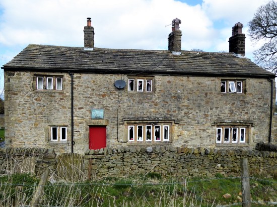
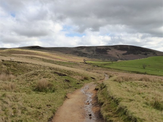
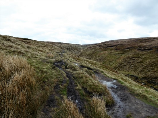
Down Rabbit Lane to the ancient Braddup House, dated 1669, where a bridleway heads north in rather wet plantations. Would be a nightmare in winter. Even when we come out of the trees the going is rough in reedy marshy fields. Height is gained onto the lower slopes of Waddington Fell. It would have been good to have carried on up to the summit but the footpaths run out before the open access begins and beside we didn’t have time. One of those iconic P&NFS signs appears, we take the path towards the fell road.

Braddup House 1669.

The boggy bit.


Waddington Fell.
We are looking for a spot to have a break but the cold wind deters us. Around the isolated Daisy Hill which I see is a listed C17th farm house, should have had a closer look. The next few fields are a little overgrown with no obvious path, well we don’t find one, but do reach the road. This is the road going over the fell to Newton. We spot in the distance houses where the Moorcock Inn used to be in the past, do you remember it? We reminisce on meals there and friends departed.

What path?
Looking at the map the next section along Mill Lane and through properties looked complicated but in fact is well signed and the natives are a friendly lot. Not sure how the planning permission process works for all these upmarket houses. We drop down to Waddington Brook but don’t follow it directly down what looks an interesting ghyll but climb back out to above the woods. The cattle have churned up the ground and therefore the going is not easy, we are glad of our overdue break taken on a large log. It is from up here that there are views across the Ribble Valley over Clitheroe to the ever present Pendle. We are coming up to a General Election next week and there have been some boundary changes, Gerrymandering comes to mind as Clitheroe, at the heart of the Ribble Valley, has been transferred to Pendle, I don’t expect the residents were consulted.

Rough ground. Pendle and a murky Clitheroe
As we loose height towards the covered reservoir at Feazer Farm we have a grandstand view of four walkers trying to find a way out of the enclosure. Our instructions tell us to skirt round to the right and we emerge into the farmyard with no problem. The four flustered lady walkers, on holiday from York, are glad of our directions. The question often arises on these outings – why don’t the farmers make it easier for us, and hence them, by adequate waymarks?

Spot the ladies.
A hidden path goes over a high stone stile and then easily down the field towards tall sycamores and Waddington. We come into the village alongside the ‘Hospital’ Alms houses. Their history is worth a read. Ladies only may apply.

The right direction.

Alms houses’ gardens.
Waddington is always full of flowers.
As I said there are three pubs to choose from in the village, we choose the friendly Lower Buck for an after walk drink in the sunshine.


A good day out with friends though not the easiest of walks to follow from this series.
For a little more information on the area and pictures have a look at my post from July five years ago.
***


 …and then I recognise the country lane I meet, Whins Lane, the original medieval road between Whalley and Padiham before the turnpike road was built lower down in what is now Read. Along here are the posh houses of Read boasting large gardens and views south across the valley.


 …and march on along past the sawmill thinking to myself that it would nave been better to have taken to the fields and woods above the lane. After a quarter of a mile I realise I should have done and backtrack to find the rather hidden stile.


 I emerge at Priddy Bank and weave through the private properties.


 It’s all down hill from here but beware, don’t take the stile directly ahead but keep to the right side of the fence to avoid very boggy ground. A wooden stile brings you out of the field into rough ground for the descent to Sabden, which is seen in perspective to the road dropping down from the Nick of Pendle. Silver birch trees dominate this last slope.


 Another from a leaflet in the series of Walks with Taste in Ribble Valley, this time setting off from the centre of Clitheroe. I’m becoming lazy with route planning and relying on someone else’s choice, Ribble Valley BC this time. It promised “starting from Holmes Mill, wandering through the grounds of Clitheroe’s Norman Castle to the River Ribble for an easy riverside ramble”


 .
.


 Too good to go back to bed. I’m motivated to get out there and do a walk. This one springs to mind.


 The path now continues back along the true left bank of the river. I’ve seen Kingfishers here, but not today. One is soon away from the razzmatazz of the picnic area only to find oneself on the busy little road to Clitheroe’s Waste Recycling centre. Past this there are only a few houses before the road ends and one is back into fields close to the river. I notice a reminder of the Covid restrictions and on the water Canada Geese are protecting their young whilst fishermen discus the best spot.


 As we leave the forest a stark metal silhouette of Chained Witches, (Peter Naylor) being marched from Pendle to Lancaster. I am impressed with the detail imparted by a few strips of metal, a reflection of the artist’s skill.


 We now follow the quiet lanes for a mile or so, at the high point Pendle comes into view again. There are lots of cyclists, presumably from east Lancashire clubs, using this switchback route. A majority of the properties seem to be holiday lets, is this the only future for English farming? See below.


 From this elevated position the Three Yorkshire Peaks are just visible but too hazy to photograph. It is a slightly better view down the Ribble Valley towards the Parlick and Fairsnape group of Bowland. And of course you can’t get away from Pendle in these parts.
 Soon we are on the return leg, again on quiet lanes, through the hamlets of Howgill, Newby and Stopper Lane. Lots of interesting buildings are passed and we guess at their original purposes.


 Here abouts is the village institute hall, a good half mile out of the village proper. But it does have an information board which tells us, all too late, about the Heritage Trail we have almost followed.


 A new path has been fashioned from the top of the Barley steps to the trig point. I must admit it blends as well as possible into the plateau and must save a lot of erosion. There is also a new stone shelter built into the nearby wall. Once through the wall as if by magic everybody disappears, and I have the whole of Pendle Moor to myself. There is no wind today, so it is almost perfect silence apart from all those soaring skylarks.


 I couldn’t resist a decent hill day as the weather remained fine. All change next week. ‘Head east old man’ was my mantra as I sped along the M65. Everyone else was going west to Blackpool or the Lakes. Boulsworth Hill my objective. So far so good, but the last chapter of Mark Sutcliffe’s Lancashire Cicerone guide would have had me parking above Wycoller. If there ever was a honeypot then Wycoller deserves that title. A secluded village of agricultural and hand loom workers in the C16th to C18th. Along came power looms in the C19th in nearby Lancashire towns and the population moved out. By 1896 the majority of people had moved away from the village, and it was virtually deserted. But a renaissance occurred in the mid C20th, the area was incorporated into a Country Park and people started moving back into the village renovating the properties. I well remember Longridge acquaintances of mine telling me of their plans for one of the houses in the 70s. I suspect you would have needed a bottomless purse to go ahead. For more information look at


 A good start to the day, although by now it was after noon. The expected crowds were milling around in the hamlet. Crossing and recrossing the series of


