Tag Archives: Yorkshire Dales.

AT LAST. THE QUAKERS AROUND SEDBERGH.

P1040903

This post has been two weeks in the writing, not that that makes it any better.

It’s been a strange time. Monday, having my haircut with Phil, a traditional barber, we all come out with the same style, fine by me. Most of our conversation was about mutual friends who have or who are shortly to depart our presence. With a humorous twist I can’t go into details here.

After my recent soaking on Longridge Fell I decided on some indoor culture for Tuesday. There were some interesting exhibitions at Abbots Hall Gallery in Kendal. I drove up in horrendous wet conditions on the motorway, found somewhere to park, £3.50, and walked to the hall only to find it only opens Thursday to Saturday at this time of year! Why didn’t I check? I phoned Sir Hugh in Arnside hoping for some sympathy and coffee, but ironically he was in Preston shopping. Drove back down the motorway in horrendous wet conditions.

Then on the Friday drove down to Manchester to visit my longtime friend, since university days, who is suffering with Pancreatic Cancer. It was a joyous occasion as we dutifully reminisced our days in various flats in London; beer, curries, girls, music and football. He showed me around his local park, John Leigh. What a wonderful space cared for by wonderful volunteers, a blue print for community parks anywhere.  

The sun shone on Saturday, Sunday and Monday but I was ill, another humorous incident I can’t recall here. The tablets were working so I hoped to take advantage of a good forecast and  complete a walk I have had in mind for some time – The Sedbergh Quaker Trail. It was not to be, three close friends died this week and I was quite depressed. I missed the good weather. 

Preparations were underway for all my family visiting at the weekend for my birthday. I awoke in the night and found that my electricity had tripped. At 3am I was paddling about in my dressing gown trying to find the problem. I isolated it to the kitchen and disconnected everything in there, but it still tripped. Into the garage for extension cables to at least keep my freezer and fridge working. The birthday dinner must be saved., not sure how I will cook it. An early phone call, Saturday morning, to our community electricians and within an an hour Paul is prowling around the kitchen with his magic electric probe. “The problem is between these sockets and the dishwasher” Visions of the walls coming down. But as both of us lie on the floor peering into the dark of that forgotten space behind the kickboard below the units the evidence is clear – a mouse has been nibbling at the wires. Within a short time he has rewired it and all is go. I’m keeping the space open until a few mice have been humanely caught and deported.

The birthday meal was a huge success. 

All of this has nothing to do with Sedbergh and the Quakers but may explain my tardiness.  

***

Historians mark 1652 as the beginning of the Quaker movement.   In that year on Pendle Hill  George Fox, (1624-1691)  is said to have had a vision commanding him to “sound the day of the Lord” to a great gathering of people.  I have written about Fox’s Well.

In June1652, fresh from his vision on Pendle Hill, George Fox arrived in Sedbergh. He did not preach in St. Andrew’s church there but the next day he was encouraged to attend a large gathering of ‘Seekers’ and other nonconformists in and around the small chapel on Firbank Fell a few miles from Sedbergh. 

Fox wouldn’t go into the chapel to preach but instead spoke for three hours to the gathered crowd from the top of a nearby crag – this is now known as Fox’s Pulpit. Many Seekers were convinced by Fox on the Fell that day and added their weight of  missionary zeal to his and what became the Society of Friends, or ‘Quakers’ – after Fox told a Derby judge to “tremble at the word of the Lord”  By 1660, there were 50,000 followers.

Meeting houses for silent prayer and contemplation, such as Swarthmoor near Ulverston, and Brigflatts near Sedbergh, were subsequently built. Brigflatts,1675, in Cumbria, is one of the most famous Quaker meeting houses, known and loved by Friends all over the world. It is acknowledged for all the simplicity of its lime-washed stone walls and interior woodwork — panelling, columns and balustrading — as one of England’s vernacular gems. For many, the peace and tranquillity of the Meeting House at Brigflatts leave a lasting impression. (information from their website.)

People of all faiths can admire the Quakers’ respect for all humans, their tolerance and belief in peace without the need for churches, rituals, holy days, or sacraments, to practice religion. Rather religion should be something one lived and acted out every day. These ideas were radical in a period where the established church held great political power, and many early Quakers were imprisoned and oppressed for these beliefs. Quakers were conscientious objectors in both world wars. Because Quakers were barred from universities and many professions, one natural outlet for them was in business.  A large number of British businesses were founded by Quakers, including such household names as Barclays, Lloyds, Carr’s, Clarks, Cadbury, Reckitt’s, Rowntree, Fry and Terry’s. The football team In Darlington that I supported as a teenager was nicknamed The Quakers from the links within the town. 

***

This Tuesday the forecast is good, Despite a bit of faffing I am parked in Sedbergh by 10 am. Too soon to pick up a leaflet from the Tourist Information Office describing this walk. I’ll just have to do it from the map and follow my nose, I think I am pretty good at that.

I pay a visit to St. Andrew’s church. Once through the cemetery I’m on a quiet lane to Birks, a hamlet of farming cottages, a brief flirtation with the River Rawthey.  P1040883 P1040884

P1040888

Through muddy fields to visit Brigflatts Meeting House. What a beautiful peaceful place. Built in the style of a Cumbrian farm house, it has open doors for visitors. The porch with its ?original studded door leads into the main room. A place for prayer or contemplation. Alongside was another room used as a library of relevant books and a place to sit and have a brew. All very inclusive. P1040895P1040900P1040896P1040899

P1040902

I move on, suitably refreshed in mind and body. I think I miss a turn to Ingmire Hall but find myself on The Dales Way for the first time in 40 years. It is a little disappointing following the road verge for some while. Some rather complicated navigating through  The Oaks, holiday lets now, and I’m on the banks of the Lune for a short stretch to the strangely named Lincoln’s Inn Bridge. The adjacent farm had been an in  at one time.

P1040927P1040931

I leave the Dales Way until rejoining it later in the day, and find a way up into the mixed woodlands which will be resplendent with bluebells in a few weeks time. For photos of them have a look at John Bainbridge’s  post from 2022. P1040941P1040947

Emerging onto a narrow moorland lane at New Field.

Onwards and upwards I reach the highest point and there on the right is the rock or pulpit from where Fox is said to have preached way back in 1652. An isolated spot as you could find. P1040954P1040957P1040965

P1040963

The plaque affixed to the rock reads –

Here or near this rock George Fox preached to about one thousand seekers for three hours on Sunday, June 13, 1652. Great power inspired his message and the meeting proved of first importance in gathering the Society of Friends known as Quakers. Many men and women convinced of the truth on this fell and in other parts of the northern counties went forth through the land and over the seas with the living word of the Lord enduring great hardships and winning multitudes to Christ.

I sit atop of the rock eating my sandwich, nobody about to hear my words. The chapel mentioned up here fell into disrepair and has vanished but there is an abandoned graveyard with one lone standing gravestone.

I choose a nearby squelchy, but well signed, bridleway to take me back down the valley. The Howgills are spread out in front of me, but unfortunately the summits are cloud covered.P1040973P1040975

P1040982

Half way down past Goodies Farm I cross the bed of an old railway. This was from Ingleton, via Kirkby Lonsdale and Sedbergh. to join the main line at Tebay. It opened in 1861 and the rails were finally lifted in 1967, twelve years after it had closed to passengers. I had previously passed below it near Brigflatts and seen in the distance the Waterside Viaduct. P1040992

I cross the River Lune on a recently rebuilt footbridge and back onto the Dales Way but now going in the opposite direction. P1040995P1040996P1040997

A series of farms and fields take me south. The farmer at Hole House complains about the wet weather causing problems at lambing time. At Nether Bainbridge most is falling down. 

Along the track a farmer is repairing his drystone wall. I get the whole history of the area. A magic conversation. P1050014

I leave the Dales Way at Bramaskew and walk on to High Branthwaite, taking the farm lane up to Howgill Lane which I can follow all the way back to Sedbergh. The alternative was to walk along the higher fellside of Winder Hill on open access land. After nine miles I was happy to use the traffic free lane. All the time looking at the surrounding fells. The Howgills, Baugh Fell and Dentdale with time to spot a few early flowers. The area is mostly neglected by hiking community who go elsewhere to the honey pots. I’ve not met a single walker all day on my ten mile round.P1050026

Back in Sedbergh the village is buzzing with visitors mostly decked out in the latest walking garb. The, no doubt otherwise helpful, Tourist Information closed at 4pm so I never acquired that walk leaflet.

P1090554

***

Screenshot 2024-03-26 205003

BELOW PENDLE AGAIN.

P1040663

I’m parked up at the same spot as a couple of weeks ago in straggly RIMINGTON. There seem to be more cars about than last time, perhaps a walking group have departed some time before me. But I never meet another walker throughout this short walk. Looking again at Clitheroe Ramblers’ 25 Walks in the Ribble and Hodder Valleys I see this is the only one I have not completed in the past. It should prove ideal for a short off the cuff walk.

P1040641

C18th Bustards Farm, my starting point in the village.

It is a pleasure to be back on the better drained limestone hills after last weekend’s mud-bath. Straight forward walking out of the village, across fields on a concessionary path and then a footbridge across Ings Beck. Robins are singing from every tree, Jays are making a commotion in the woods, yellow Celandines are poking through and the sun is shining, so perhaps we have turned a corner in the seasons. I’m soon alongside Twiston Mill and on to the minor road. I resist the short diversion up to Witches Quarry, a popular limestone climbing venue.

P1040653

Twiston Mill.

P1040658

Its silted up mill pond.

Each chapter in the book is written by a different local author and the standard of accuracy has varied, todays is not the best and I have to resort to my OS mapping on the phone to find my way above Twiston. Its uphill all the way to meet the next minor road. I recognise some stretches from a reverse walk in March two years ago which helps. The Blackthorn Blossom is just starting, as it was last time I came this way. P1040666P1040665

P1040667

Looking back to the Ribble Valley.

All morning Pendle Hill has been looming above me, a little hazy at times and at the road its big end is directly above. The scenery changes here, I’ve left the green pastures and  venture onto the open moors for a stretch above Coolham Farm. This is the highest I get on Pendle’s skirts. I have to imagine Ingleborough and Pen-Y-Ghent ahead of me in the haze but can pick out Rimington far below.P1040670P1040673

P1040675

Out of nowhere a wall enclosed green lane appears heading down from Twiston Moor. I follow it, doglegging, until alongside a deep wooded clough, the upper reaches of Ings Beck. I try to take some pictures of the red buds on the Larches here but the breeze makes it difficult to focus. P1040683P1040680P1040691P1040687P1040695

Just outside the garden of Clough Head Farm is the Thomas Peel Bulcock memorial of which I knew nothing. It was erected by Thomas Bulcock in 1863 in memory of his son buried here and other relations buried in Whalley and Downham churchyards. The Bulcock family apparently had a long association with the area. P1040698P1040701

Having passed through the farmyard I find myself in one of the longest fields I’ve seen in these parts. Back to green pastures I wander down the hillside to come out onto a familiar lane. P1040704P1040705P1040710

From there I traverse the hillsides above the Ings Beck where silver rich lead was mined for many years. I wrote about this last time. Today I find the remains of the limekiln for the little limestone quarry and pass the mine managers cottage. Oh and that lamp post in the middle of nowhere.

Knowing the way I am soon back into sleepy Rimington. P1040739P1040746

P1040749

The converted Black Bull and Cosgroves ladies clothing shop. 

 A sprightly five miles.

***

Screenshot 2024-03-06 172555

RIMINGTON – ‘Time flies swiftly away’.

P1040552

For a change you may start this post with a  piece of music to set the scene.

The  tune is the hymn ‘Rimington’, composed by Francis Duckworth. He was born in the Ribble Valley village of Rimington on Christmas Day 1862 at the grocery store, now a house. When he was five he moved with his family to nearby Stopper Lane, where they ran the village shop next door to a Wesleyan Chapel and hand loom cottages, now all private residences. Francis’s mother died when he was 12 and he began a hard life of working in various family shops. He later opened his own grocer’s shop in Colne. He was well known throughout the area as an accomplished musician and organist and composed many hymns, often named after local villages. ‘Rimington’ appeared in 1904. He remained in Colne until his death in 1941. He is buried in nearby Gisburn’s churchyard where his memorial is inscribed with the first couple of lines of his famous hymn.

Screenshot 2024-02-26 003410

*

We find ourselves parked this morning in that village of Rimington to follow another walk from Clitheroe Ramblers – 25 Walks in the Ribble and Hodder Valleys. Once again under the shadow of Pendle Hill, only a few miles from touristy Downham where I was a couple of weeks ago. But there are no tourists here, it is a curious village strung out along the lane with no obvious centre and a variety of housing styles. The Black Bull pub mentioned in the guide is nowhere to be seen, presumably closed. 

Anyhow we find our footpath heading into the fields – it is marked as a Heritage Trail, of which we know nothing. Some of the stiles are hard to spot with the sun in our eyes; as is Pendle towering above us. Yes, at last the sun is making a weak appearance today. In places the stiles have been replaced by those utilitarian galvanised kissing gates. I’m still not bowled over by them, being a dyed in the wool old git; see below. Anyway we head towards a farm through more tradional old gate posts and past a street light in the middle of nowhere. Bits of limestone break through the grass giving us a clue to the geology of the area. P1040511P1040514P1040517P1040519P1040522

Before we go farther I would like to do a poll on which of the following you feel is most appropriate in our countryside, assuming progress has to be made. Galvanised or green?

 Disused mines are marked on our map, perhaps they are something to do with the heritage trail. On the ground, pits start to appear all over the hillside and across the other side of Ings Valley. Apparently silver rich lead was recovered from here originally in the C17th from bell pits and later on an industrial scale from mine shafts. A smelt mill was built in the C19th.  “Between 1880 and 1885 the York & Lancaster United Mining Co. Ltd sank a shaft and raised some ore. Unfortunately, James Wiseman, the banksman in charge of the shaft top, fell down the shaft and was killed in September 1884”  This latter information I gleamed later from the internet where Rimington’s heritage is well represented. We should have known this before to fully appreciate and interpret the area. P1040526P1040528P1040530P1040529

We come across a small limestone quarry but fail to spot its limekiln.P1040532

There is probably a lot of heritage around here.

In the distance below Pendle is listed but modernised Clough Head Farm. We are almost on the border of Lancashire and Yorkshire hereabouts. I remember when White Rose flags were flown in Gisburn long after it had been assimilated into Lancashire. Lanes, which switchback the slopes, bring us to Middop Hall, C17th and again listed but without much change. A grand display of mullioned windows. Somewhere in the barn are remnants of Sawley Abbey. The stone from the abbeys must have been reused in many farms in the area, we have  passed some at Little Mearley Hall before. P1040536P1040537P1040543P1040541

Shortly after leaving Widdop Hall we get into conversation with a friendly farmer on his quad bike. After the usual discussion on the weather he opens up and tells us he lives at the Hall and relates its history. If only we had met him down there we may have had a closer look around.

Onwards on the deserted lane with more ups and downs than I want. Then we are heading up onto the slopes of Weets Hill to join the Pennine Bridleway on Coal Pit Lane, more heritage there.
P1040548P1040550From this elevated position the Three Yorkshire Peaks are just visible but too hazy to photograph. It is a slightly better view down the Ribble Valley towards the Parlick and Fairsnape group of Bowland. And of course you can’t get away from Pendle in these parts.P1040551P1040553Soon we are on the return leg, again on quiet lanes, through the hamlets of Howgill, Newby and Stopper Lane. Lots of interesting buildings are passed and we guess at their original purposes.

P1040558P1040559

A lot we walk past without a second glance, never mind a photograph. We do notice the plaque to Duckworth in Stopper Lane, but had no idea of the industry here. The historic photo is of the village’s joinery shop with its ‘windmill’. Screenshot 2024-02-24 213325Screenshot 2024-02-24 213447Here abouts is the village institute hall, a good half mile out of the village proper. But it does have an information board which tells us, all too late, about the Heritage Trail we have almost followed. P1040562

If you are planning to visit this area be sure to download this map from their website. https://www.rimington.org.uk/index.php/rimington-s-heritage/heritage-trail   We wish we had and feel the need to go back and check out our omissions. 

*

Screenshot 2024-02-25 231719

The sundial on Martin Top Chapel, under scafolding today, is a reminder that this life we live is short and fleeting, and also seems to comment on the changes that have occured quite rapidly in these working villages in our lifetime.

***Screenshot 2024-02-24 203735

THE FINAL STANZA?

P1030041

It never used to be so busy at the Cow and Calf Rocks’ carpark  A bright Saturday has brought crowds up here above an equally busy Ilkley. We are here to find the last of Simon Armitage and Pipa Hall’s  Stanza Stone Poems, Beck, hidden in Backstone Beck where the latter comes down at speed towards the town. I have downloaded some ‘simple’ directions but am afraid I may get distracted by the nearby climbing crags.

Ilkley Quarry, the Cow and Calf and the Rocky Valley were favourite haunts of my early climbing days. There was plenty of traditional excitement to be had on the rounded gritstone. But no let’s find the poetry stone first.

‘Take the path out of the car park’ was an obvious start, we could manage that. The paths are more well used than I remember them, were they even here back then? But there are lots of them going off in all directions. And there are people in all directions too. Some coming up from Ilkley by way of the tarn, most like us wandering from the Cow and Calf and others from over the moor. Dogs, in all shapes and sizes, are everywhere, which gives Zola plenty of canine interactions, Clare is on hand to call her in when things are starting to get out of hand. I am amazed that she can bound off into the distance (Zola, not Clare), in a place she has never set foot in, and keep reappearing at our heels. The bracken is dead which helps us find the narrower paths. All the time we have a panoramic view of Ilkley down below in the Aire valley. P1020983P1020984

‘Head towards a plantation’ was the next  instruction, yes, but which one? A solitary Stanza Poem fingerpost then takes some of the adventure away. The sound of the beck meant we were close. ‘Scramble up alongside the beck’ was our instruction – but steps have been provided recently. ‘Squeeze through between a gorse bush and a boulder’  the guide says. But someone has cut the gorse bush back. Is this all down to the YouTube/Instagram/what three words phenomena creating honey pots in our wild countryside? I’m beginning to feel a little cheated, this was to be the climax of our poetry trail with the most difficult stone to find. Zola obviously finds it for us, but then in the end we have it completely to ourselves. P1020990P1020995P1020996

P1030007

False trail 

P1030009

P1030012

Is this what you are looking for?

What a spot, a wild tumbling beck with the brown bracken clinging to the hillside. Water is splashing around the rocks and there in the centre of it all is the Stanza Stone. A proud boulder sitting in the flow as was Pipa Hall when she carved out the letters. We ask ourselves how did they find this elysian place?  P1030027

P1030017

P1030032

P1030025

P1030017

It is all one chase.
Trace it back the source
might be nothing more than a teardrop
squeezed from a Curlew’s eye,
then follow it down to the full-throated roar
at its mouth – a dipper strolls the river
dressed for dinner in a white bib.
The unbroken thread of the beck
with its nose for the sea
all flux and flex, soft-soaping a pebble
for thousands of years, or here
after hard rain, sawing the hillside in half
with its chain. Or here, where water unbinds
and hangs at the waterfall’s face, and
just for that one, stretched white moment
becomes lace.
©Simon Armitage 2010

A bit of precarious scrambling had us up close to the poem which is slowly taking on the patina of all the other water splashed rocks. What will it be like in another ten, twenty or fifty years? all a very short period of time for the stones up here on the moor. The references to the curlew and the dipper are perfect for the situation. If you have read any of Simon Armitage’s poems you will recognise his acute observation, engagement and ability to weave his words. If you haven’t, a good start would be an anthology of his writings – Paper Aeroplane, 1989 – 2014. The title poem at the very end is one of my favourites, a self-effacing offering worlds apart from Tennyson, Simon is no stuffy Poet Laureate.

Where next? Well I had suggested we explore the wild moor looking for those thousand years old markings in the rocks up here. Cup and ring marks and geometric carvings. I won’t bore you with our subsequent wanderings. Zola probably derived the most benefit from the open moorland obstacle course. Did we find any? I can’t say for certain, lets just leave it there. I don’t know who C Clark and Crackety Jack are.P1030074P1030048P1030051P1030053P1030062P1030111P1030094P1030100P1030120

Our only trophy was stumbling across a ‘poetry seat’ constructed in line with the poems. The sign said Marsden 451/4 miles, where we had started with Snow up in the quarries at Pule Hill in October. We have not walked the whole trail but picked off the stones on the way – Rain, Mist, Dew, Puddle and now Beck. Whichever way you approach it this gives a wonderful feeling for the Pennine scenery, the vagrancies of its weather and the talent and inspiration of the poetry team.

Going with the flow Clare posts a poem into the letter box. I wonder when it will next emerge.P1030088P1030087P1030083P1030080

On our way back to the car I indulge in some reminiscing of those carefree climbing days long ago. P1030103P1030109P1030123

There was no congratulatory drink in the nearby Cow and Calf Inn, a quick toilet stop and I was happy to be on my way home before all those high intensity car headlights had chance to confuse me. How the mighty have fallen.

***

There is however a post script. Our journey is not yet done.

The final Stanza?  Armitage and Hall spoke about a seventh, hidden Stanza Stone. Although they disputed its size, both agreed it was fairly small and had been placed within either a “wooden casket” or “hollowed-out log”.  Armitage added: “We took it to a place above Hebden Bridge, where the Ted Hughes poem ‘Six Young Men’ is set, and placed it under the riverbank there.” Shortly afterwards the valley was flooded, “so we’ve no idea where it is now. It’s either in the Atlantic, or in the North Sea – or lying in someone’s cellar in Todmorden”.

Let me know if you come across it.

***

Screenshot 2024-01-25 163951

EDEN VALLEY, MALLERSTANG.

P1010297

Time to head into the hills. After a good breakfast I  was ready to be away fairly early from the pub. Interestingly the garage opposite had more farmers’ quad bikes in for servicing than cars. P1010656

P1010175

Refueling.

It was a short drive up the valley into Mallerstang proper. On the way I passed the ruins of Pendragon Castle. The early morning light was so clear that I made a quick photographic stop in case things were murkier when I returned, it starts getting dark between three and four.

There is a lot of legend associated with the castle. it was supposedly built by Uther Pendragon, the father of King Arthur. It is said he tried to divert the river to form a moat.

A well known local couplet goes –

    Let Uther Pendragon do what he can,                                                                                                     Eden will run where Eden ran.

 The castle was built during the reign of King Rufus in the 12th century by Ranulph de Meschines,  After attacks by Scottish raiders in 1541 it became uninhabitable until the C17th when Lady Anne Clifford inherited it. She rebuilt it and added to it in 1660. It remained one of the favourites among her many castles until her death in 1676 at the age of 86. She spent her time between Skipton Castle and here in Westmorland  becoming involved with local affairs and restoring several nearby churches. A long distance walk tracing her travels passes this way. There is a statue of her in Kirkby Stephen market place. P1010666

 Her successor, the Earl of Thanet, had no use for the castle and removed anything of value from it, By the 1770s much of the building had collapsed. It now stands as a romantic ruin with pointy Wild Boar Fell in the background. P1010185P1010188P1010189

Whilst wandering around the ruins I was treated to a flypast by a Lockheed Hercules. P1010205

I drove through Outhgill which I visited yesterday and parked up at The Thrang for a walk I had picked off the net. It would take me up to the first Eden Benchmark, Water Cut – before visiting Hell Gill and its waterfalls, and then wandering back past valley farms.P1010209

Quite a broad track headed away from the valley floor, an old bridleway to Hawes at the head of Wensleydale. All the rivulets coming down from Mallerstang Edge were in full flow and my feet were wet after the first ford crossing. P1010224P1010221

That dot on the horizon turned out to be the benchmark in its very prominent position – how come I have never spotted it before? After some steady walking and a few more fords it was reached at about 420m. P1010225

P1010236

P1010234P1010241

Water Cut by Mary Bourne. 1996. 

“Water Cut is located a few miles from the source of the river Eden, high up on the eastern side of the Mallerstang valley. Like a huge milestone, it stands alongside the ancient green road known as Lady Anne Clifford’s Way. The space carved between the two vertical pillars creates the shape of a meandering river in the sky and provides a ‘window’ onto the real river in the valley below. It also symbolises the power of the river Eden cutting through the rock on its journey through East Cumbria and our own human journeys through the rural landscape and through life. Made from Salterwath Limestone, taken from a quarry near Shap, it also resembles the gate posts and stiles in drystone walls, which are so characteristic of the area, whilst it’s outer curve makes reference to the viaduct arches on the nearby Settle-Carlisle railway.”

Mary Bourne is an accomplished stone carver,  living in the North East Scotland. Her work explores forms of the landscape and her relationship with the natural environment.

I played about with various camera angles. The more I looked they resembled two salmon leaping, are there salmon in the Eden?

P1010253
P1010252P1010245

P1010247

P1010289

From up here one has good views north along Mallerstang Edge and across the valley to Wild Boar Fell. The limestone lower layers contrasting with the overlying gritstone.

Not much farther I came to Hell Gill, I could hear it well before I reached the bridge over it. A deep rift in the limestone tearing down the hillside with thrashing waters in its depths. This was dramatic. I tried to get views down into the canyon but it was sensibly well fenced off. All was green mossy and ferny, I think there are fairies down there. P1010346P1010352P1010366P1010372P1010377P1010388P1010398P1010401

The water tumbled on down the hillside and I followed. It came to a welcome rest at a ford. P1010409P1010418P1010422P1010424P1010433

But what was that noise? A small steep detour and I could see the next and probably the best cataract. A video should have been taken. P1010440P1010451

P1010459

My boots were under water crossing the fast flowing ford.  P1010462

It must be all downhill from here but the next few miles tried my patience. I was basking in the beauty of Mallerstang and yet struggling to find the bridleway marked on the map on the ground. There was a lot more rough walking to come. It tended to keep above the top intake wall and hence involved tussocky grass and boggy areas. Few people use this way. P1010464P1010480P1010513P1010533

There were a few more waterfalls to admire and the light on the other side of the valley was beautiful. No steam on the Settle to Carlisle today.P1010550P1010472P1010477P1010466

Eventually I made my way to the valley bottom and along by the Eden back to my car just as the sun was going down behind Wild Boar Fell.P1010539P1010565P1010572P1010579

P1010582P1010600P1010635P1010625

I would highly recommend this walk, it packs a lot into those 6 miles without going onto the tops. I never saw another person.

Mallerstang-trail.pdf (edenriverstrust.org.uk)

***

Capture

CaptureMallerstang

THE CRAVEN LIME WORKS.

P1020519

I’m enjoying a lunchtime pint of Tetley Bitter in the Craven Heifer in Stainforth. The last time I was here was at the end of February 2020 when I stayed a night mid-walk.  “It was Chinese New Year, and they were fully booked in the restaurant for a Chinese Banquet, but the chef was able to cook a fish and chip supper for me before festivities commenced.” There was talk in the bar of a new virulent virus spreading in China. We all know what happened next. P1020561

Hopefully the virus is now behind us, and it is good to be walking in Limestone Country. The barman says the pub closed during lockdown and only reopened under new managers last year. It is still owned by Thwaites, the present landlord has a five-year lease but grumbles that trade hasn’t really picked up. One problem is that the village is becoming dominated by holiday cottages, not many locals left, and the cottages are only occupied less than half the time. Who would want to run a pub in these cash strapped days?    I finish my pint and bid them good day.

I’m halfway on a short walk mainly devised to explore the Craven Lime Works. It was only recently that I was made aware of this Industrial Heritage site on the delightful Walking Away  site. I must have walked and driven past dozens of times without realising its existence.

There is further information from these two sites.

 Visit Settle – Craven Lime Works & Hoffman Kiln “Without doubt the centrepiece is the huge Hoffmann Kiln. Built in 1873 it is a huge industrial scale lime kiln” 

and more thoroughly  Craven and Murgatroyd lime works 400m north east of Langcliffe Mill, Langcliffe – 1020888 | Historic England

Good, that’s saved me trying to interpret and explain everything.

There is no signage off the road north of Langcliffe, but Hoffman Kiln Road  sounds promising, it leads to a large new purpose built office and light industrial complex in the grounds of the former lime works. A lot of money has been spent by Craven District Council, with help from European cash – we are going to miss that. I only hope this is a successful enterprise as at the moment the majority of the units are standing empty.P1020623

The almost hidden car park for the Industrial Heritage site is impressively large even with electric charging points. It is situated directly below the massive old quarry on the hillside that supplied all the limestone for the kilns. We used to climb up there in the distant past, I think that is discouraged now. Today I am the only car parked on the site. P1020635

P1020619

I wander into the ‘preserved’ site, the interpretation boards are very good. This has been a vast industrial complex  – limestone from the quarries, converted in coal-fired kilns to lime which was transported off site by the integrated railway. As well as the kilns there are so many other associated ruins to see – inclines, winding houses. weigh bridges, water courses, tunnels, old rails, tram ways, spoil heaps.  The operation lasted from the mid C19th to the 1940s.

Capturelome works1909

1907 OS map.

First I look at the remains of the buttressed bases of a pair of massive vertical Spencer steel kilns. Difficult to visualise the scale of this operation that provided purer lime from the beginning of the C20th. P1020508P1020507

Back round onto the quarry floor and a dilapidated weigh house. P1020514

And then along to the Hoffman Kiln – wow it’s massive, think football pitch. In I go, you don’t need a torch as the frequent limestone inlet arches give enough light, in fact a magic image. I’m enthralled. There are the vent  holes for the smoke up to the now demolished central chimney; there are the holes in the roof for the coal inlets; there are the ageing firebricks; there are the miniature stalactites from the slow seepage over the years. Are there bats or giant spiders in here? I walk around the massive kiln twice, and even think about a third, this is so atmospheric. P1020629

P1020521

P1020624

P1020528

P1020529P1020527

P1020525

P1020543

P1020627

At the far end is a tunnel which accommodated a line bringing stone from the quarry above. A waterway used for counterbalancing a crane lower down delivering fuel into the kiln from the roof. Ingenuity far beyond our present engineers involved in the HS2 going above budget from week to week. They can’t even sort out the Euston terminus after 10 years, money down the drain, revised plans costing another £5bn!  How many cycle lanes could you build for that amount of money.

P1020534P1020535

The only part of the complex that wasn’t viable was the separate Murgatroyd quarry and overhead triple kiln next to the railway at the northern end of the site. A smaller scale operation which collapsed in 1887. Today I couldn’t make out the tops of the three kilns for the abundant vegetation, I realise now I should have dropped down to see the lower outlet of the kilns. P1020548

P1020549

Industrial history satisfied I walk through the fields up to Stainforth and my pint. I come back, not on the familiar riverside path but on a higher way through Stainforth Scar. Gently climbing out of the meadows into the trees on the scar and emerging on the limestone plateau. The way ahead is etched into the fields, signs of an ancient passage way to Winskill Farm. 1675 says the date stone with the initials NBCB. What history could these walls tell. It is surrounded by what look like traditional meadows with a variety of flowers and butterflies.P1020569

P1020590

P1020587

P1020573P1020558

From up here looking back over my right shoulder is the prominent Smearsett Scar and distant Ingleborough. Over my left shoulder Pen-y-ghent has suddenly appeared quite close by.P1020579P1020581

There are some tempting ways leading to Attermire Scar from here, but I’m only looking for a short day. My path is clear through stiles in the extensive network of fields and old lanes. The view is down the shallow valley with its patchwork of fields to Langcliffe. That’s where I was planning to head, part of Wainwright’s Pennine Journey, until I spot a vague path/sheep trod going between a wall and the Langcliffe Quarry, now alongside. Will it take me on a shortcut?  I said I was looking for a short day especially after that pint. Worth a try and yes it brings me out into the Lime Works without any serious obstruction, but don’t necessarily follow me on any of these walks. Mine was still the only car in the car park.P1020596

P1020592

P1020601

P1020608

P1020603

P1020617

I would highly recommend a visit to the Craven Lime Works with or without a walk.

***

CaptureHoffman Kiln. (3)

CICERONE’S LANCASHIRE – GRAGARETH’S MEN.

P1020312 (2)

Well there were JD and me, the three scientists doing a peat survey for some research organisation, the Three Stone Men who have been there for who knows how long, and a few others stone ones scattered around. The peat survey was interesting as we are just waking up to the importance of peat as an important carbon storage resort. We were happy to sit in the shelter of the Three Men as there was a distinctly cold breeze coming from the Northwest. A good opportunity to take a break and eat our sandwiches.

Our journey up the motorway had not been straight forward as I missed the turn-off to Caton and the Lune Valley. Another junction farther north and JD’s phone chose an alternative route over towards Kirkby Lonsdale, although eventually on the A65 we ignored the lady navigator and followed the sign up to the little hamlet of Ireby.  I shall not reveal where we parked, but there should be space by the telephone (book) box. Surely we are in Yorkshire by now, but no the Lancastrians have pushed a finger into Cumbria and Yorkshire.  We are in fact out to climb the highest (allegedly) hill in the Red Rose county, walk number 16 in Mark Sutcliffe’s Cicerone guidebook.

Up to now we have been walking on a distinct lane out of Ireby and then the tarmac road heading up the fell from Leck. All easy going, gaining height almost effortlessly, at least we could keep up a good conversation without getting out of puff. JD is super fit at the moment having recently completed a pilgrim route to Santiago, a Scottish trip and The Dales Way. I was hoping that his all-inclusive hotel stay in Menorca with his wife might have slowed him down. We are in limestone territory. P1020289P1020292P1020298

This road leads to a remote sheep farm. I used to park up along here for exploring the nearby Leck Fell potholes. Short Drop Cave was always a favourite, lowering yourself in with your feet dangling in fresh air in the darkness, dare you let go of the rock? Of course, you did and only dropped a few inches! You could explore the channel for some distance and then worry about getting out again. But today we were heading up to those stone men visible on the hillside above. Conversation dwindles on the steepest scrambling bit, look at the contours, and we are all too ready for that rest at the Three Men. P1020305

P1020310

The Three Men.

P1020321

The Three Ladies.

P1020315

Lunch over we chat to the peat surveyors before strolling the last section to the lonely trig point on Gragareth, 627 m, the highest in Lancashire. Now this is where some debate comes in, farther north across the barren moor is Green Hill, still in Lancashire, and marked on the OS map as 628 m. We don’t fancy the two-mile boggy trudge up there. But help is at hand – in 2014 the Database of British and Irish Hills suggested  “Gragareth replaces Green Hill as Lancashire county top”.  Gragareth having a height of 628 metres, 100 metres east of the trig point, while Green Hill is 627.5 metres. Who knows?  P1020324

Anyhow, we slink off along the wall southwards. But I have forgotten to tell you about the views from that highest point. Morecambe Bay, Lakeland hills, nearby Barbon fells, all those rounded hills up to Dentdale, Whernside and of course stately Ingleborough, distant Pendle and the Bowland Fells, quite a collection.

P1020323

Northwards.

P1020334

Whernside.

P1020329

Ingleborough.

On down along the wall and then a vague path down to the ‘Turbary Road’ above Kingsdale, a track used by peat cutters – yes we have been destroying the land long before climate change was thought of. This area is full of caves, potholes and dry riverbeds, but the way missed most of them out. On reflection a few small diversions to peer into these limestone features would have added interest. P1020331

P1020338

P1020339

Marble Steps Pot.

P1020345

Twistleton Scar End.

P1020344

Turbary Road.

Once on the lane we made good progress stopping only at a bench for a drink, out of the vegetation crept a giant dung beetle. P1020348

Masongill looked delightful.P1020349

Freshly cut green fields, and we were soon crossing the ancient clapper bridge into Ireby.

P1020350P1020353

It was good to be back in Limestone Country, as you can see the weather improved as the day went on. Eight and a half miles with 1700ft of ascent – I’m still thinking imperial.

***

CaptureGragareth (2)

LET’S LOOK AT SOME LIMESTONE.

I’ve not been far from base recently. There is a cousin, ‘the pieman’, living in Skipton whom I’ve not met up with for two years. Admittedly, he has phoned me on several occasions with a suggestion for a walk, but I have always declined with the excuse of injury. This can’t go on. It turns out he is suffering also, so when I suggest a short walk, on his home territory, the die is cast.

Yorkshire Limestone has been a favourite climbing venue for me over the years. Malham, Gordale, Attermire, Twistleton, Crumack Dale, Oxenber – the list goes on. The last time I visited the imposing Pot Scar the polish on the holds was unnerving, so in recent years, we retreated to the safer bolted climbs of Giggleswick. Why not revisit some of these venues on today’s walk.

There used to be a garage or was it a café on Buckhaw Brow above Settle, but now all is bypassed, and my mind is clouded. In the past, buses came this way, struggling up the hill from Settle. We are parked on the Craven Fault. Limestone high on the left and gritstone down below on the right where the land has slipped. My knowledge of geology is rudimentary.

‘The pieman’ is proud to display his vintage wool Dachstein Mitts, once an essential item of all climbers, famed for their warmth and water resistance. They had the added advantage that when winter climbing, they could virtually glue you to the ice. Are they still available?

The little roadside crag is examined, yes there would be routes on it, and then we are off along the airy escarpment. A path is followed, linking stiles in the substantial stone walls, with views down the fault to Settle. Up to our left are limestone cliffs with hidden caves, we are heading for Schoolboys Tower, a cairn associated with Giggleswick School down below. Stones were added to the cairn by pupils on their last, or was it their first, day. A smaller nearby cairn has been named Schoolgirls once the school had admitted the other sex.

Having reached the ‘tower’, looking a little dilapidated, we went in search of Schoolboys Cave down below on the steeper escarpment. A bit of scrambling, and we found the entrance to what was only a short cavern, curiosity satisfied we then peered into the more cavernous quarry nearby, now redundant.

What followed was a mistake. I wanted to link up with The Dales High Way coming out of Stainforth. The obvious way would have been to follow the River Ribble or even the quiet road up the valley from Stackhouse. No, I eschewed both for some cross-country  escapade involving some inelegant and illicit wall climbing. I hope the farmer is not reading this, although despite risking damage to his walls, our clothing and appendages, not a stone was dislodged.  As a diversion, we were treated to  excellent views of  the stately  Pen-y-ghent.

Things improved once we were on a signed path. Over the rise, the long escarpment of Smearsett Scar led us on. We started to meet more (sensible) walkers. The last time we were here, we climbed to the trig point on the Scar for its views, today we were less enthusiastic and settled into a wall for lunch. I regret not recording for historical evidence the size of ‘the pieman’s‘ sandwiches.

My eyes were scanning the cliffs of Pot Scar for routes often climbed. Will I ever return to those steep walls?

The farm at the head of Feizor was busy with cattle being let out onto the higher fields. We stood aside as the stockmen herded the cows, calves and a moody bull. Feizor was always a sleepy hamlet, but now there is a café and several holiday lets. Despite this, I think It will always be at the back of beyond.

As we gained height, looking back to Feizor the distinctive top of Ingleborough could be made out. New finger pointers show us the way back across clipped limestone grasslands to Buckhaw. We were both feeling the effects of a short but unintentionally fairly strenuous day.

Make that a splendid day.

*****


MISSION ACCOMPLISHED, CONFUSED ON CROOKRISE.

                                                   Crookrise and Embsay Crag in the early morning.

*

Most of what I have to say today is irrelevant. Putin is focused on invading Ukraine on false premises, and a peaceful nation is being annihilated.

*

The object of the day was to reach the trig point on Crookrise at 415m. Sir Hugh has had an ongoing mission to visit all the 76 trig points on OS map 103, mainly in the NW part of Lancashire, although today we are in Yorkshire. This would be the final summit, and he duly touched the shining white pillar early in the afternoon, congratulations on another challenge completed.

Fortunately, we had chosen a blue sky day and the views were sparkling. In the background, on the picture above, is the lovely little ridge of  Sharp Haw on the edge of the busy Dales town of Skipton. Down the Aire valley was all floods. In a northerly direction, the monument on Rylstone was prominent and the rift of Deer Gallows showed up clearly, reminding me of a long day when we climbed on all six crags on this edge of Barden Moor with a lot of rough walking between them.

Our rendezvous on this occasion was the free car park in Embsay village to make a hopefully interesting circuit, it turned out to be a full day in the hills. Above the historic village, once busy with mills, is the shapely Embsay Crag, and this was our first objective, although at the time we hadn’t realised it. In my mind, the path traversed below it en route to the reservoir, but no, we were slowly guided onto the summit. And what a summit, surrounded by gritstone craglets with a 360  degree view. The vast interior of Barden Moor with Deer Gallows, distant Beamsley Beacon, Embsay and its reservoir directly below, even more distant Pendle and the fell wall leading up to the Crookrise summit. Along the valley below, a steam excursion was puffing on the short stretch of restored railway.

C18th Embsay Kirk.


C19th Embsay Church of St. Mary the Virgin.


Embsay Crag.


Beamsley Beacon and Eastby Crag.

Looking back to Beamsley Beacon and Eastby Crag.


Embsay Reservoir and sailing club.

A problem was how to reach the route up onto Crookrise without loosing too much height, we failed and followed a decent path down to the reservoir. This took us past a secluded ghyll complete with a lively stream, magic.

Rough ground to Crookrise (top right)


Back up to Embsay Crag.

I was glad of not carrying a full climbing rack and rope up the steep track, past the perfect little boulders where we used to stop off for some warm up entertainment before the main event. Sir Hugh had promised a nostalgic visit to Crookrise Crag after the celebratory trig visit

Heading up newly flagged path.


Trackside boulders.


First view of the crag over the wall.


That trig point.


Floods in the Aire Valley.

 My regular climbing partner years ago lived in Skipton, still does, so Crookrise, on his back door, was a frequent venue for our early struggles on gritstone, I knew it well. From the trig point I thought I saw a way down to the base of the rocks – but our first attempt, and second, and third, ever more precarious, only landed us into a world of moss and conifers, many of those precariously toppled by recent storms. Obviously too far west. Back up to the top, we retreated several times and yet tried again without success. This was jungle warfare that stretched Sir Hugh, and I felt embarrassed and responsible. Let’s sit down and have lunch was my best solution. I didn’t know it as well as I remembered. I tried to distract him with views across to the splendid crag at Deer Gallows.

A tight squeeze.


Pulling on heather.


Temporary escape, time for lunch.


Deer Gallows and Embsay Crag.


Zoom to Deer Gallows.

Composure restored, we climbed the wall onto the access track and headed down the fell, our tails between our legs. More stiles were passed and investigated without any obvious ways down, but the last seemed to ring a bell in my memory. I was over and looking down on the End Slab of the main crag. Sir Hugh was ‘keen’ to follow, and soon we were stood below the slabs. The rock was in perfect condition, and I was regretting not throwing my rock shoes into my sack. But maybe my memories deceived me, the slab was steeper  and relatively holdless, drawing one on to even more difficulties higher up, which I may not be able to succumb. I was content therefore to admire smugly from terra firma. The rest of the crag stretching west into the trees will have to wait for another time, even I was loosing my enthusiasm.

There must be a way down.


At last.


Another time.


Can we go now?

Moving on…

Back on the descending track, we met up with a pleasant couple, ‘birders’ by the look of them, who were out for the day with their binoculars. In typical Yorkshire banter, they  commented on farmers, walkers and most emphatically irresponsible dog owners. On the whole, we had to agree with their sentiments, though we debated the finer points as we progressed down past the reservoir. Our contributions to bird watching were Greylag Geese on the water and Oyster Catchers swooping above.

Heading down.


Greylag Geese.


Oyster Catchers.

The industrial heritage of Embsay was in evidence, with mill chimneys and mill races as we entered the village past the Manor House. It was difficult to believe it was 4 o’clock back at the car, I’ve no idea where the time went. Sir Hugh hasn’t divulged his next project as yet.

Past history.


Manor House, 1665.


Could be interesting.

For Sir Hugh’s version of the day, see    conradwalks: Trigs 103 – Final trig of 76 – Crookrise Crag

and for those interested in the crags mentioned

UKC Logbook – Embsay Crag (ukclimbing.com)

UKC Logbook – Deer Gallows (ukclimbing.com)

UKC Logbook – Crookrise (ukclimbing.com)

    *****

SALT OF THE EARTH.

                                             Salt’s Mill.  Oil on two canvasses.  D Hockney 1997.

Titus Salt was born in Morley  on 20th September 1803, the son of a successful wool merchant. He joined the family firm, which became one of the most important worsted companies in Bradford. He took over the running of the firm in 1833 when his father retired, and eventually owned five mills in Bradford. The city became a horror story of the Industrial revolution, with poor working conditions, squalid housing, polluted air and water supplies. Life expectancy, of just over eighteen years, was one of the lowest in the country.

To improve matters, Titus decided in 1850 to move his business to a green field site where he built an industrial community on the banks of the Aire and next to the canal. Salt’s mill, Italianate in style, was the largest and cleanest in Europe. At first his 3,500 workforce travelled from Bradford, but to improve their lot over the years he built housing for them. He integrated into the Saltaire village:  parks, churches, schools, hospital, almshouses, railway station, public baths, libraries and shops. But no Public House. Clean water was piped in, gas for lighting and heating, and outside loos for every house. He did charge a rent for his properties but provided superior living and working conditions, a model of town planning in the C19th.

Titus Salt died in Dec 1876 having given away much of his wealth to good causes. The business continued under his sons but over the years declined, wound up and sold to business syndicates in 1893.  Textile production continued into the mid C20th and finally closed in 1986. The village itself had been sold to the Bradford Property Trust in 1933 thus enabling the houses to be bought by their occupiers.

An outstanding entrepreneur, Jonathan Silver, bought the Mill the following year and within months opened a gallery exhibiting the work of his friend, Bradford-born artist David Hockney. With Silver’s enthusiasm, the mill developed into the vibrant space we see today. He died young, but the enterprise is still run by his family.

Saltaire was added to the UNESCO World Heritage List in 2001, recognised for its international influence on town planning.

Well with all that write up it was time I paid a visit to Yorkshire. A wet Sunday in February was chosen. I drove through the floods down the Aire Valley. You realise the scale of the mill and village as you pull off the hectic suburban road.  The car park was busy despite the foul weather. As well as the historic buildings and the connection with the artist Hockney: the mill now houses cafés, upmarket retail outlets, artist materials, an excellent book selection, antiques, cycles etc. All waiting to make a hole in your wallet, though the parking and entry are free. I had come basically to see Hockney’s artworks, but was impressed with everything else that was on offer. Everything is on a grand scale here, from the size of the stone building blocks to the massive indoor floor spaces.


You enter into the long ‘1853 Gallery’ with works by Hockney from different periods as well as a large selection of artists’ materials, all under the gaze of Titus Salt. The walls are all windows, so ingenuity has been needed to display the Hockney pictures. Time to get  used to the large scale of this place.  Hockney started his career at Bradford College of Art school (1953–57) and the Royal College of Art, London (1959–62), Portraits have always been an important part of his works and some early examples are exhibited here…

Red Celia. Lithograph 1984.

Margaret Hockney. 1997 oil on canvas.

…as well as some of his more recent computer generated portraits.

The next floor up was a gigantic book and poster shop where I had to be extra strict with myself. The queue for the diner looked daunting. Somewhere behind in the depths of the mill was an antique centre, an outdoor outlet and an upmarket home and kitchen showroom.

Having manoeuvred around all these, I arrived in a long gallery with some of Hockney’s abstract offerings from his time in Malibu Beach.

Round the corner was a stunning ceramic installation depicting Batley and Bradford by Philippa Threlfall, 1972.

I eventually found the way up to the top floor where I sat and watched a video of the history of Saltaire from which I gleamed my information for this post. In the next room were some historical artefacts.

As you move around the galleries, there are views out of the windows reminding you of the extent of this building and the surrounding village.

The major Hockney exhibition was on the top floor. In the first space was a video presentation of his iPad and iPhone pictures using the brushes app, which he emailed to friends. They came up three at a time and were a variety of vibrant styles. The larger exhibition was entitled “The Arrival of Spring” – a series of iPad paintings done on different days from his car parked on a Yorkshire Wolds lane from January to May in 2011. He made the most of the portability and speed of using the hi-tech iPad, capturing  subtle changes in the light. He was able to print them out on a large scale

“These pictures celebrate fleeting moments of intense beauty, and remind us of the importance – and the joy we get from looking closely.”

I’m ready for Spring – aren’t you? Worth clicking for enlarged images.

I came out of the mill to a broody winter day with hail showers moving in. I wanted to have a look at some nearby Saltaire streets, under the shadow of the mill, before the light disappeared. The terraced houses were obviously now desirable properties, and the shops on Victoria Street appeared prosperous. Chic Yorkshire.

Next time I will give myself more time – a grand day out.

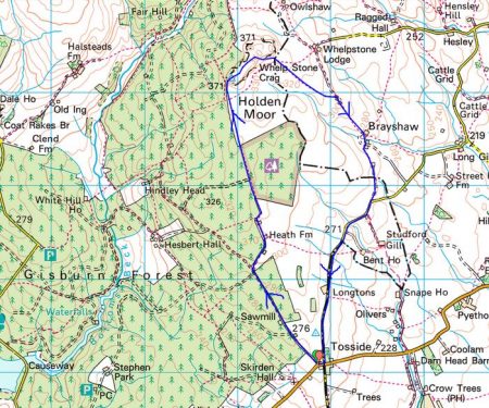
WHELP STONE CRAG – Gisburn Forest.

                            Distant view of Whelp Stone Crag peeping out of vast acres of Gisburn Forest.

I parked in Tosside; a church, a village hall, a war memorial in the middle of the road and an inn that is closed.

St. Bartholomew.

War memorial and ‘pub’


On the map the track leading to Whelp Stone Crag looked straightforward, a lane to a farm and then a footath alongside Gisburn Forest. As far as the farm the lane was good but the path onwards diabolical, difficult to follow on the ground, encroaching trees and waterlogged for most of its length. Why do I always seem to find these horrors?  I could hear the mountain bikers on the Gisburn Forest trails whooping with delight, I hope they could not hear my cursing. I would not recommend this approach, there are probably better traks within the forest.

The crag in sight over more rough ground.


Anyhow I arrived at the trig point, 371m, on top of a fragmented gritstone edge. Ravens were cavorting about in the updrafts. There must be some good bouldering on these rocks. From here I could look down on the bikers speeding along the trails. There were 360 degree views over Pendle, Bowland and into Yorkshire although the higher peaks were cloud covered. I was the only person up here.

After a snack as I was preparing to leave a couple arrived on the summit. ” That was the worst path we have ever been on” was their opening conversation. I had no idea what they meant.

The ongoing ridge was a delight before trackless slopes took me down to squelshy fields where farmers were rounding up their sheep. Across the valley, A65, were the limestone hills of the Settle area.

The unmarked footpath just about navigated me through or around, I was never sure which, several farms called Brayshaw. They all had a well worn look to them and were undoubtably of vintage.

Passing a smarter residence I reached some tarmac on a minor road. I threw in the towel and followed it back to Tosside. I think I was in Lancashire most of the afternoon but the oulook was Yorkshire Dales country.

*****

RIVER WENNING AND ‘THE BIG STONE’.

The River Wenning comes out from the Craven limestone dales and heads towards the Lune.  Today we were constantly reminded of the Dales by the presence of the Three Peaks on the horizon. The river takes its name from the old English ‘wan’ meaning the ‘dark one’ and within yards of the carpark we were crossing its rushing brown waters. These waters in the past powered mills in the Bentham area, originally for flax but later turning to cotton and silk. Here at Low Bentham modern accomodation has been developed in some of the old buildings.

It was a pleasure to walk upsteam chatting to Sir Hugh especially after the last few stressful weeks. Before we knew it we were in a massive caravan park, part residential and part tourism. We were impressed as to the quality of the park but what would you do here all the time.

After exracating ourselves from the park we climbed little used paths linking farms up the side of the fell. Some tidier than others.

Fourstones Farm

Once on the open fell the object of our walk appeared on the horizon across boggy terrain. The Great Stone of Fourstones stands on the Lancs/Yorks boundary. Known locally as ‘the big stone’, it is a glacial erratic gritstone. Originally as the name suggests there were three others which were broken up by farmers, but I can find no reference as to any dates or why one stone survived. A feature of the stone is a set of worn steps carved into the side, easier to climb than descend. I remember playing here with my children and finding more adventurous ways to the top. Today we were entertained with an ascent by a passing motorcyclist in his unsuitable footwear. The stone is covered in carved graffiti.

Leaving here we weaved a way across the fell to descend past interesting farms with the dramatic view of the Yorkshire hills ahead of us.

Gragareth, Whernside, Ingleborough and Penyghent.

Grusckham.

A late lunch was taken sat on a couple of stones only to pass a perfect wooden seat within a hundred yards. This is a frequent occurence on walks which remains an unexplained quandary.

Dawson.

From time to time we were strafed by Chinook type helicopters which had the conversation ranging to ‘Mash’ – Hawkeye, Hot lips and Radar. We are of a certain generation.

Back on the River Wenning we bypassed Higher Bentham village using a lane by riverside mill cottages. Once through another large caravan park we took paths on the north side of the river to Lower Bentham.

Sleepy Lower Bentham.

Yet another interesting walk in unfamiliar territory. Are there more in this area?

*****


A SETTLE CIRCULAR. Second day.

“I may not have gone where I intended to go – but I think I’ve ended up where I needed to be”  Douglas Adams.

As I slogged up the steep lane out of Stainforth I was regretting the good and filling breakfast I’d just eaten in The Craven Heifer. I’d had a quick look around the churchyard, crossed the stepping stones over the beck and then followed the Pennine Bridleway signs. At the top of the lane was a gate giving access to some more spectacular waterfalls – Catrigg Foss. A placid beck wanders through upper pastures before disappearing into woods. Looking down from the top only revealed a very steep ravine with the water rushing way down below, it was time to explore the lower reaches by a steep path. The falls tumble down in two stages through vertical strata. A magic place to while away time.

Back on the Pennine Bridleway, I cross fields to reach a footpath going towards Attermire, passing a prominent erratic on the way. The day was not looking good with low cloud covering all the tops, down to about 400m. The bridleway I was intending to follow would be in the mist all the way to Ryeloaf Hill which couldn’t be seen – my resolve faltered. I was close to Jubilee Cave so I thought I would climb up to have a look not having been here for years. The two entrances were obvious and I went into the main one but didn’t explore further. This cave and several others in the area have been excavated finding animal bones from before the last ice age and evidence of early human since. There is a large platform area outside the cave, more evidence of human activity, where I sat and had a coffee and debated the day. Why not explore a few more caves at Attermire and then take a shortcut to Rye loaf if the cloud lifts.

So I took the footpath leading around the corner passing Wet Cave … … just spotted on the photo that good looking layback crack to the right of the cave.

Higher still was the larger Victoria Cave, discovered in 1837 and excavated extensively. Plenty of animal bones were found. The earliest, at 130,000 years old, [Upper Pleistocene interglacial]  when the climate was much warmer than today, included hippos, rhino, elephants and spotted hyenas. The glaciers returned and the cave filled with clay.  After the last Ice Age brown bear and reindeer bones were found as well as an 11,000-year-old antler harpoon, the first evidence for people in the Yorkshire Dales.  More recent Roman layers yielded bronze and bone artefacts including brooches and coins. The inner depths of the cave are now barred to preserve any further archaeological finds but I remember years ago exploring deeper connecting passages.

Returning down to the main path which goes south through the gap between Warrendale Knotts and Attermire Scars.

The back of Warrendale Knotts.

This area was one of my favourite climbing venues with a whole range of buttresses and tiers of limestone, all facing south and giving a huge variety of routes.  The scene as you approach the rocky crest from the south reminds me of those old cowboy films when hundreds of Indians suddenly appear along the horizon. Today one could hardly make out the features shrouded in mist. Anyhow, I walked on to find the trod leading up through the screes to the long escarpment where I remembered Attermire Cave should be.

It seemed much steeper and exposed than I recall but I think the mist added to the atmosphere. I reached an area of solid rock which I recognised from past climbs, Hares Wall etc, some of the best VS to E1 routes hereabouts. The vertical rock is immaculate limestone with cracks and pockets leading to overhangs higher up. I was pleased to identify so many climbs but I couldn’t find Attermire Cave itself. Exploring around the corner I came across the vertical cleft of Horse Shoe Cave, more of a landslip than a cave. Now pacing back and forth along the base of the cliffs I remembered that the cave I was looking for was on a higher shelf. [It’s there on one of the photos above!]  So  I scrambled up at a likely spot and traversed airily along a ledge to an exposed step into the mouth of Attermire Cave. The cave entrance is smoothed off from the previous flow of water, phreatic, and one can walk in, under an ominous wedged boulder, for several metres before a crawl takes you through to another chamber. I was not equipped for crawling today but the light on my mobile illuminated the outer large chamber well enough. Again this cave has yielded animal remains but also more recent human artefacts including of all things part of a chariot suggesting the cave had some spiritual significance.

Views were restricted so I retraced my steps carefully and descended the screes below. In the valley floor, previously a lake at one time, are metal targets apparently commissioned in the C19  when it was thought France may invade. They were used again before WW1.

There was no point going up the valley to climb Ryeloaf Hill as it was completely obscured by the low cloud. Another time. To save the day and incorporate a ‘loaf’ I climbed the easy low Sugar Loaf Hill on the way back to the car.

On reflection, my amended walk would be better called ‘Caves and Fosses,  AKA Loaves and Fishes’. I had made the best of today’s weather by keeping low and searching out those caves. I ended up climbing 20000ft in the space of 5miles.

*****


My Settle Circle below…

Caves and Fosses Walk.

A SETTLE CIRCULAR. First day.

You often hear the sound of crashing waterfalls before you reach them. A sign off the road directed me to Scaleber Foss in a wooded valley. Scrambling down to the base gave the best views as the water cuts through the horizontal strata. There are some lively smaller falls before  the beck disappears down a valley at a more sedate pace to be met later.

I had just started another walk plucked from the LDWA database. A circular 23-mile walk in Limestone country from Settle in North Yorkshire named  ‘Loaves and Fishes’. I enjoy a two day walk away from home, I’m not sure this brings it into the long-distance category but it is a good excuse to have a night in a pub halfway. Considering the winter days and my level of unfitness this walk would seem to fit the bill perfectly. At the last minute, whilst parked up at the start I changed the direction of my walk to fit in with the weather forecast, rain today and maybe drier tomorrow when I would be higher in the fells.

Back up onto the road, I was soon on an old lane following Brookil Gill, this is Langber Lane an ancient drove route linking Settle with Otterburn and on through to Skipton. Easy walking left me thinking on important topics: the state of the world politics, our future after so-called Brexit this Friday, Coronavirus, our own mortality and is that water getting into my right boot?

After a hop across the beck, a path continued into pasture land where the stream from Scaleber Foss joined at a wooden footbridge. An ideal wild camping spot.

A steep climb out of the valley and I joined a lane overlooking Long Preston, one minute I could see it and next clouds and hail showers obscured the view. As I came out onto a road there was a bench perfect for an early lunch. I’m not sure why this road heading onto the moors is surfaced, there are no properties up there. On old maps it is Queen’s Road [? Elizabeth I ] and was the direct route from Long Preston to Settle over Hunter Bank before the turnpike road was built in the valley in the 18C. An old milestone was thus inscribed.

Dog walkers told me of the fine views up and down Ribblesdale, not today. Once over the top, I took to a direct footpath and a blurry Settle appeared below me. Little lanes, some still cobbled, thread their way into town. I took a coffee and dried out in The Folly, a late C17th manor house built by a wealthy lawyer Richard Preston.

I didn’t have time for more coffee and cake in the Ye Olde Naked Man, formerly an undertakers with a ‘naked man’ on the outside wall, 1663 covering his privates. There were more delights to discover off the beaten track in Settle. Narrow streets, quaint cottages, a Quaker burial ground and an old Victorian Music Hall.

I was aiming for a footbridge over the Ribble and then I would follow the river upstream past Stackhouse and Langcliffe Weir to Stainforth. The imposing large quarries at Langcliffe were in the gloom. I must be on a Long Distance Walk according to the signage. The going was muddy and by the time I arrived at Stainforth Falls, the light was fading. Sat-Nav is responsible for wide vehicles becoming stranded and damaging the old packhorse bridge.

I stayed the night in The Craven Heifer,  a friendly and comfortable inn. There are a number of pubs named after the Craven Heifer, a massive cow bred on the Duke of Devonshire’s Bolton Abbey estate at the beginning of the C19th.

The restaurant was fully booked for a Chinese New Year banquet but the chef was able to cook a fish and chip supper for me in the bar before festivities commenced. There was talk in the bar of a new virulent virus spreading in China.

The fish was significant as it was the only one I saw all day – remember the title of the walk. The loaves come tomorrow but the fish are the salmon seen in October/November leaping the falls at Langcliffe and Stainforth, not my battered variety.

Gung hay fat choy!

*****


BARDEN MOOR AND RYLSTONE, last of the summer wine.

A vigorous day visiting old haunts with wide-ranging views.

The Duke of Devonshire, Bolton Abbey Estate, owns a large area of grouse moorland NE of Skipton. Confusingly Barden Moor to the west of the Wharfe and Barden Fell to the east. I’ve spent many days on these moors mainly on their edges climbing on Rylstone Crag, Crookrise, Eastby and Simon’s Seat. I felt it was time to revisit and make a walk of it across the moors. The Pieman doesn’t get out much so when he phoned suggesting a walk this week I gladly agreed and decided on this walk on his local hills. I cajoled JD into the party to show him a new area. Wednesday was the day and the forecast was for improving weather, but first we had to get rid of the tail end of Hurricane Dorian. Early morning and the rain was still heavy, I even had a phone call from Skipton querying opting out but I’m made of sterner stuff. Miraculously as we drove across the skies cleared and the sun came out, there was a sneaky breeze when we met in Rylstone.

Rylstone with its duck pond and church; the famed ladies who produced the original nude Calendar;  the inspiration for Wordsworth’s 1808 poem ‘The White Doe of Rylstone’ and above the village Rylstone Cross.  The latter was visible on the fell as we set off but it would be several hours before we stood alongside it.  Originally a stone figure, the ‘Rylstone Man’,  changed to a wooden cross to commemorate the ‘Peace of Paris’ in 1814. This had to be replaced several times until the wooden structure was replaced by a stone one in 1997. I remember a wooden cross held by a metal frame from early trips to Rylstone Crag.

A bridleway climbs away from the road and was followed easily into the heart of the moor. We chatted away and hardly noticed the increasing tailwind. The heather, unfortunately, was past its best. Views started to open up to familiar hills but putting a name to them often eluded us. Simon’s Seat across Wharfedale was prominent. Upper Barden Reservoir came into sight and veered off on a track to it.  Sitting on an ancient stone gatepost out of the wind we had an early snack. Across the dam was an old waterboard house, we speculated on its value – isolation and views against accessibility.

The estate has signed most of the tracks and we changed course once again heading back to the moor’s northern edge.  Another small reservoir was passed and we focused on an old chimney up the slope, this with some obvious old pits suggested past mining activity.

As we reached the edge I regret not diverting a short distance to look at Numberstones End, a small gritstone crag.

By now the wind was almost gale force and difficult to walk into, JD’s hat became the focus of attention as it somehow stuck to his head. We took our second break in a beaters’ shelter, the shooters more commodious lodge being firmly closed. We gazed across upper Wharfedale to Grassington, Buckden Pike and Great Whernside, Grimworth Reservoir with Nidderdale behind. The Three Peaks were hidden in cloud.

Refreshed we commenced battle with the wind as we bypassed Rolling Gate Crags and made a beeline towards an obvious Obelix, Cracoe War Memorial erected to honour the dead from the Great War with a plaque added for the 2nd WW. It was difficult to stand up on the summit because of the wind and we set off down the ridge towards Rylstone Crag and its Cross. Now below was the limestone country around Cracoe and the contrasting greens of the Winterburn Valley.

A visit to the base of the main face of Rylstone Crag was obligatory to gaze up at President’s Slab, Dental Slab and all those other climbs that have given me so much pleasure in the past. Last climbed six years ago.

President’s Slab.

Dental Slab.


The cross was another gale swept vantage point now looking towards Pendle.


  A couple of boulders took our attention and we played around trying to stand up in the hole or reach for an edge, only long-limbed JD was successful with the latter. We reflected on ageing bodies and ‘the last of the Summer wine’ as we trotted down the hill back to the car, getting out of the wind and enjoying the warm sunshine.

*****

Not a grouse was shot during this walk.

*****

NORTHING 438. SALTAIRE TO HORSFORTH [LEEDS]

What could have been an uninspiring day in the hinterland of Bradford and Leeds turned out to be almost a green corridor of pleasant walking. It was not difficult to keep close to our lateral line with the proviso from Sir Hugh to incorporate a visit to his primary school in Thackley.

From the rail station in Saltaire we quickly reached the Leeds – Liverpool Canal to follow it off and on throughout the morning. At first all was industrial, historically relating to the canal with some fine mill buildings brought into the 21st century.

There were a few scattered sculptures including this one which was a pun on the Salt Mill connection…Hanging on the wall of my garage is an Ellis-Briggs cycle frame, probably 40years old, so I was delighted to pass their establishment which has been building steel frames since 1936. The cycling scene was booming in the 1930’s and the other notable established builder was W.R. Baines, whose factory was based at Thackley, see above and further into the walk. Coincidentally I rode a 1950’s Baines ‘Flying Gate’ cycle for many years.


Some nondescript scenery followed enlivened by some dubious and unsuccessful canal boat manoeuvering, it is difficult to do a three point turn.

Climbing away from the canal on cobbled paths above railway tunnels we entered Thackley, a mixture of old stone houses and modern estates, and found Sir Hugh’s school still open and extended since his time. Up here was the local cricket club with a very challenging sloping pitch, Sir Hugh’s father had been a member.

From the map we were not sure whether we could access the canal towpath from open country but thankfully there was a bridge. Soon we were sat on a bench looking down locks near Apperley Bridge, this was a busy stretch with pedestrians but no boat movements.Crossing busy orbital roads took time unless there were lights. We switched from the canal to follow the River Aire alongside the sports grounds of Woodhouse Grove School. The river continued through remarkably rural scenery despite being close to the railway and new housing developments.

Pleasant suburbs gave us twisting streets heading for Hawksworth Park which turned out to be a wooded valley. More parkland and upmarket housing and we arrived at our excellent budget hotel for the night.

*****

SKIPTON TO LONGRIDGE 2 – winter sunshine.

Barnoldswick to Chatburn.

Late sunshine under Pendle.

In Gisburn churchyard hidden in the long grass is the grave of Francis Duckworth, 1862 – 1941.  One of my recent diversions has been searching for significant gravestones with the help of a book by Elizabeth Ashworth – Lancashire Who Lies Beneath? and I’d recently found his. He is remembered as the composer of the hymn tune ‘Rimington’. Have a listen –

https://hymnary.org/hymn/SCM/56

We had found a bench in Stoppers Lane for lunch opposite the Rimington Memorial Institute and on a nearby row of cottages I noticed this plaque –


JD [now aka Doug} the Pieman and myself had started outside a Rolls Royce factory in Barnoldswick and wandered indirectly through the mill streets as close as possible to our Skipton to Longridge line. It was a perfect sunny winter’s morning.Until the 1974 local government reorganisation historic ‘Barlick’ was in West Yorkshire, as several of the other villages visited today. The rivalry/frienship between the two roses counties is continued today and highlighted on some benches in town. We spent the morning navigating fields and lanes past both old and renovated farmsteads, through the hamlet of Howgill and into the scattered Rimington village. We were in close proximity to streams which eventually become Swanside Beck that joins the Ribble near Sawley.

To the northeast were Ingleborough and Penyghent and to the northwest Longridge Fell, Beacon Fell and Fairsnape.

After lunch using back lanes we seemed to avoid one of Rimington’s famous features – Cosgrove’s fashion shop. We dropped down to Ings Beck and Downham Mill.Soon the Ings Beck Joined Swanside Beck and we were alongside the familiar packhorse bridge. The next bridge we were on was that high one crossing the A59…… from where there was our last view of distant Ingleborough before we stroll down into Chatburn before the sun sets.

*****

SKIPTON TO LONGRIDGE 1 – another straight line.

Skipton to Barnoldswick.Following on from the success of the straight line from Longridge to Arnside completed with Sir Hugh at the end of last year I have persuaded ‘the pieman‘ a resident of Skipton to undertake a similar scheme between our respective abodes.

The Pieman.

He is a lifelong friend, possibly blood related though I tend to ignore that, with whom I’ve shared many backpacking trips throughout Europe but recently we have not been able to meet up as much as required. So this was a good opportunity to get 2019 off on a better note. Thus I was drinking coffee in his house in Skipton early this morning before setting off on what could only be described as a drab day.

My local guide takes us across Aireville Park, where I used to play as a child, over the Leeds Liverpool Canal and out of town through an industrial estate with some interesting relics awaiting restoration.

Airedale Park.

We crept under a main road and crossed the placid River Aire on an old track into Carleton. This essential bridge for our route was just within the mile either side of our arbitrary straight line  The C19 mill in the village was originally for cotton-spinning but I remember buying carpets there in the 70s, apparently it is now luxury apartments.

Carleton.

Today we didn’t visit the village but took to unmarked footpaths through green drumlin fields. I have to concede that satellite tracking maps were a great help in navigating this section. We were going parallel to a disused railway [Skipton to Colne] and eventually we found ourselves walking along it for convenience until stopped by vegetation.Possibly we touched on a Roman Road leading to Elslack where there was a fort. Our priority was to find a picnic bench and there right in the middle of the hamlet was one in some sort of memorial garden. Having put his instant coffee powder into a cup he looked for the flask containing the hot water, unfortunately it was on the worktop back in Skipton. I had hot apple tea in my flask so he ended up with a strange brew.

We walked past the C15 Elsack Hall but at a discreet distance and then along the abandoned railway into Thornton-in-Craven joining the Pennine Way for a short stretch. The village has interesting old houses but no shop or pub and the heavy traffic deterred us from lingering.

Tree planted for the Coronation of Queen Elizabeth.

?Millenium Clock.

On the edge of the village are Almshouses built for poor women, there is not much of that charity evident today.

By the church a sign guided us to a Holy Well in the grounds, dating from Saxon times it is covered by an octagonal structure erected in 1764 by the rector.

On a short stretch of golf course we joined The Pendle Way. It weaved around a church and graveyard where every grave was decorated with flowers, presumably from Christmas.

Rolls Royce have a large presence in Barnoldswick and we passed one of their factories before joining the Leeds – Liverpool Canal for the final stretch into town. My overall impression today was of green fields and a rich historical background.

*****

TWISTLETON SCARS. Climbing on the SW Face.

The main crag at Twistleton hosts many low grade classic limestone climbs and was once a regular venue but slowly the polish increased meaning it fell out of favour with my group of climbers. Thats a shame as the rock was of such good quality and the situation in Chapel-le-Dale spectacular with Ingleborough brooding above on the opposite side of the valley. I wonder if due to less people climbing, not just because of the polish but with the rise in popularity of bolted routes and bouldering, left to nature the rock may roughen once more.  A few outlying crags were developed but we found these a bit short and scrappy, nowhere near the quality of the main crag. The exception to these was a separate area the South West Face, a small compact crag which in fact hosted some of the earlier climbs on the scar back in the 60’s Allan Austin era. This area had avoided the excesses of the main crag particularly no groups and remained a bit of a connoisseur’s area with climbs only on the lower grades.

My gardening induced shoulder pain had stopped me climbing for a few weeks so for today’s outing with Dave I wanted something gentle and he volunteered to do all the leading to tempt me along. He had taken a bit of a beating on gritstone the week before so when I suggested the SW Face limestone he was happy. My day didn’t start well as the cheap Aldi trousers which I had climbed in for over a decade finally disintegrated, a sad loss.  It is so long since either of us had been in Ingleton we were not even sure of the lane to take leading to the crag and once on it were surprised by how narrow it was. Anyhow eventually it straightened out [thought to be of Roman origin here] and we were in the correct valley, the northern side of Chapel-le-Dale. Ingleborough was indeed brooding over us and the show caves on its flanks seemed busy with cars and coaches, it was a lovely Summer’s day.

As is usual the approach to the crag seemed longer and steeper than in our younger days. On previous visits we had probably ticked most of the climbs but had to get out the guide book to reacquaint ourselves.

The start of the starred VD above our sacs looked a bit bold and sketchy so we looked elsewhere for a warm up route. The short easy one we did convinced us of the quality of the rock here and the lack of any polish so we were feeling pleased with our choice of venue. Back to that VD, well maybe not yet. There was a good steep climb left of the tree which followed a line of solid flakes that was very enjoyable. After a leisurely lunch soaking up the sun we avoided that VD by climbing a series of jugs up a steep rib – not a bad move on the route whose name gave a clue. After that we couldn’t procrastinate any longer. A closer look at the steep wrinkled wall in front of us revealed small flakes and even a crafty threaded runner so Dave had a sequence worked out and was soon finishing on the upper wall. The climbing was indeed quality but we both thought under graded for an onsight ascent. To finish the day there was another starred severe crossing a black wrinkly slab round the corner. The start was uninviting and the traverse unclear, though I don’t remember on past visits any difficulty. Anyhow I was in Dave’s hands today and he found an alternative start further right which used flakes to climb more directly up to the superb finishing wall, could even be a new variation route.

The pictures may give some indication of the quality of the rock, the vegetation was not a problem. The climbs were only 10m or so.

Tree Stump Crack D

Tree Wall S *

Juggernaut S **

Play For Today VD ? *

Twinkle Variation S *