Category Archives: Bowland Fells.

DEEPER INTO CHIPPING VALE.

The Lazy Loud River.

There was a beautiful sunrise today which heralded good weather to come.

I’d arranged with JD to continue our intimate exploration of Chipping Vale by following as close as possible the little River Loud on its way to join the Hodder. My route was ambitious as from previous experience I know some of these paths are rarely walked. I was hoping for an easy day because of my recent stiffness and should have been concerned with the first stile we encountered off the road, awkward and overgrown.

Dr. Livingstone I presume.

To be honest we never really found a convincing path through the fields to the limestone Knainsley Quarry and once we were in its extensive area compass work was needed to get out. We emerged onto a lane bounded by expensive property conversions, lots of Range Rovers – that sort of place.

The next stile was impossible to negotiate, guarded by brambles and sloes, [reported to the authorities] but fortunately a gate took us into the same field to link up with a path that kept coming to more awkward overgrown stiles, but we slowly made progress to emerge probably on the wrong drive way at Loud Carr Side. All along this stretch we had wonderful views of the Bowland Fells to the north. Their road led us to Gibbon Bridge over the Loud. A substantial stile gave access to the river bank  here populated with Himalayan Balsam and more worryingly Japanese Knotweed, The river is small and flows along at a snail’s pace. Pushing on through the vegetation we made progress down stream, despite acrobatic stiles, to the stepping-stones  across the river. A few days ago there would have been little water here after the drought but we have had a lot of rain since and our crossing was a little tricky as some of the stones were submerged. A gentler stretch through fields and we emerged at Loud Mythom Bridge. What are these  iridescent beetles ‘feeding’ on dock leaves?  We walked on to Doeford Bridge where the Loud joins the much wider Hodder. A fisherman was casting in the Hodder below, a popular fishing river. We ate lunch at the bridge and watched many cyclists coming through from  the Trough of Bowland, and also speeding motorists having close shaves on the bends.

The Loud joining the Hodder just above Doeford Bridge.

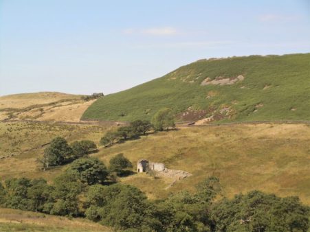
We had considered continuing across the stepping-stones at  Stakes Farm but walkers coming in the opposite direction confirmed that they were impossible with missing stones and high water which is a regular problem. So we backtracked up the lane and onto a track heading for Greenlands, as we walked through the farmyard a, fortunately chained, dog leapt out of its kennel narrowly missing JD. That raised our heart rates.  More poor tracks and awkward stiles eventually brought us back to Gibbon Bridge. Cars were arriving for a wedding reception at the hotel. We didn’t have the heart to find the footpath through their grounds and spent the next half-hour or so lost in the fields which host the annual Chipping Steam Fair every May. Today turned out to be the Chipping Show held in fields on the edge of the village and we could hear loudspeaker announcements in the distance. The day was perfect for the show. From this side of the Loud we now had uninterrupted views south to Longridge Fell. A complicated series of fields, all thankfully well signed, took us from Pale Farm to the road and back over the Loud Lower Bridge to our car. We had achieved our idea of following the Loud but had found the walking difficult, in my condition, with overgrown paths and broken or blocked stiles.

*****

DEEP IN CHIPPING VALE.

One of the tags for my blog is ‘Chipping Vale’  and its used quite frequently.   I’m often looking down into this valley as it lies between Longridge Fell and the Bowland Fells. I’m not sure whether this is an official designation or a figment of my imagination. There is no mention on the OS maps, basically I’m referring to the Loud River catchment area which arises in the hills near Beacon Fell and meanders under Chipping into the Hodder at Doeford Bridge. Well today we’ll explore into this valley.

Chipping Vale from Longridge Fell.

There are several  points of interest – historic houses, ancient bridleways and limestone quarries. I’ve a book about limestone kilns and quarries in the area which highlights Arbour Quarry at Thornley as a major commercial  site, so I was keen to revisit it.

Since my trip up the NE coast of Scotland I’ve hit a problem – I suddenly overnight painfully stiffened up in my shoulders and thighs. After some prognostication I presented myself to my GP – Polymyalgia Rheumatica [PMR] was his initial diagnosis,  but the blood tests were equivocal. Give it another week and nothing much has changed, painful stiffness and similar bloods. I’m limiting myself to gentle walks around the village later in the day when I’m less stiff.

To hell with it I’m going for a longer walk and phone JD for companion, he’s strong enough to carry me if things become difficult.

So our venture into Chipping Vale commences. Field tracks out of Longridge are taken past ponds, where my lads used to fish for tench, to Gill Bridge over the River Loud, more of a stream than a river, where they had tickled unsuccessfully for trout. Private roads through the Blackmoss Estate formerly Lord Derby’s domain took us past converted barns and gentrified houses as is the norm around here. Indistinct field paths which seemed little walked brought us into the farmyard of Hesketh End a grade one listed C17th house.  The sandstone house has lovely mullioned windows and is noted for Latin inscriptions on the exterior telling of historic incidents.

Hesketh End.

Chipping Vale with Longridge Fell in the background.

A nearby  property was ruinous 20 years ago and is now a substantial dwelling. We came out onto the road close to the recently closed Dog and Partridge, many pubs are capitulating in rural surroundings. From here we crossed the River Loud by a wooden footbridge. The banks of the river were heavily overgrown with Himalayan Balsam, its scent pervading the area. The low-lying meadows here are frequently flooded in the winter months when our track would be underwater. We were heading for the extensive Arbour quarry, a source of limestone into the early C 20th. Lime was important to the farmers for improving their land. All that remains now are grassed over ridges and ponds, the latter having a large duck population. Sitting on a limestone outcrop for lunch we were covered with little black flies which fortunately were of the non-biting variety. We couldn’t identify them but they were similar to ones I call Thunder Flies, it was certainly very humid today. There was wild mint growing  everywhere giving a strong aroma and attracting Painted Lady butterflies. I had vague memories of a large limekiln somewhere here but we couldn’t find it today in all the summer growth. There is a photo in my book of it operational.

Crossing to the other side of the valley we climbed a lane to reach farms strung along the hillside of Longridge Fell on roughly the 150 m contour. I’ve often speculated this may be the spring line. Paths and lanes connect these properties and is known to some locals as ‘The Posties Track’. Some houses are still honest working farms but more and more are renovated as desirable properties, I must admit they all have superb views over Chipping Vale towards the Bowland Fells. We re-entered Longridge on the old railway line that ran along to stone quarries. The gentle walking was no problem but my stiffness made getting over the numerous stiles comical.

*****

BIVI ON LONGRIDGE FELL.

A unique experience.

I’ve been meaning to sleep up on Longridge Fell during this good weather but other things keep getting in the way. Made an effort last night before I disappear off to Scotland and arranging a late evening lift up the road was a great help. So at about 8.45pm I set off on the familiar track to the trig point. A few stragglers were wandering back down to the carpark and they wished me well. A few sheep looked at me strangely. The sun was already low and would go behind the Bowland Fells soon. I wasn’t going to see the sun setting over the sea at this time of year from up here, may have to have a night up on Fairsnape soon for that which would complete my trio of local fell bivis – including Beacon Fell.  [Memo to myself – better sleeping bag, camera as opposed to phone and a tripod.]  By the time I reached the top the sky was changing and the sun disappearing, I sat and watched with the three peaks clear to the east. A kestrel hovered right above me but soon flew off into the gloom leaving nothing but silence.

There was a cool breeze blowing from the north so I decided to go over the wall for a sheltered bivi spot and luckily found an almost level site yards from the trig point. I heard deer barking but none appeared. I was probably asleep by 10 but woke about one feeling decidedly chilly. I had my lightest sleeping bag and no spare clothes so couldn’t do much about it. There is little light pollution up here, a few lights down in Chipping, so the stars were clear, the moon was almost full. The next time I woke, about 4.45am, the sky was colouring over Yorkshire so I sat up and watched the changing display until the sun was fully up, 5.30am.  A lot of misty patches hung in the fields below and there was heavy condensation on my bivy bag suggesting the temperature had dropped considerably in the night. I managed an hour or so fitful sleep before packing up and walking home to the village just as it was coming to life. Another fine summer’s day in prospect highlighted by my night on the fell.

*****

THE HEAT GOES ON.

Beacon Hill, Grindleton Fell.

I’ve just eaten a punnet of cherries with a beer whilst watching Belgium beat Brazil in a World Cup  game . The lazy days of this summer are passing by and now we have Wimbledon and The Tour de France to distract us.

 The pieman and I met up at Chatburn earlier today. I was glad we made the effort. At one point when we were aimlessly wandering around in a field in the midday sun I questioned our sanity. We had descended from up high on Grindleton Fell and were aiming for the River Ribble but fences and obstructions were in our way giving rise to some scribbles on my route map below.

We had started off on an old lane out of Chatburn which when face to face with a massive limestone quarry took us down to the Ribble and along a concessionary path to the bridge. On the outskirts of Grindelton, a village worth exploring , we picked up a rising bridleway which passed by some interesting houses – Victorian Green Banks, Georgian White Hall and spacious and pretentious Cob House. The old Yorkshire expression ‘where there’s muck there’s brass’ came to mind as we speculated on who lived in these expensive properties. Then we were in the rough country above an old abandoned yet evocative farm.

We skirted the forest and ended up on the rarely visited Beacon Hill with a trig point at 305m, high enough for me today. We took the opportunity to relax, eat lunch and look at the views over the wooded Ribble Valley to Pendle and northwards towards the ‘Three Peaks’. A group of teenagers were struggling up the hill towards us, all heavily laden and no doubt on a DofE course. The ones at the front were chatty but the tailenders obviously had no desire to be where they were.

Hazy Pendle.

We passed through more desirable properties, thankfully guarded by docile dogs, before our episode of being lost, hot and bothered. Soon we were on The Ribble Way which in these parts upstream has been cruelly diverted away from the river by landowners with angling interests. We enjoyed our stretch of the river however as we headed back to Grindleton bridge and as the river was so low we contemplated a shortcut wading across. Oyster catchers and ducks lazed about on the rocks in the heat of the sun.

We cooled down with an ice cream from the famous Hudson’s shop in Chatburn, it was good to catch up with the pieman and we made plans for future forays.

*****

BOWLAND AT ITS BEST.

Looking up past Dunsop Bridge into the heart of Bowland.

14th June 2018. UK weather: Storm Hector batters Britain with winds of up to 100mph.

The above headlines in today’s papers were not encouraging but delving a little deeper and being three brave fellows we arranged a walk. We being ‘the rock man’, JD and myself. The idea was to stay low and leave late morning to avoid the worst of the storm. Leaving late was easily accomplished as the rock man was late anyhow. We parked up near Leagram Estate above Chipping avoiding any overhanging suspect trees. There was no sign of the wind abating.

Entering a windy Leagram Park.

Country lanes were used to weave through the fields bordering the fells. More and more barns have been converted into desirable residences and expensive 4×4’s kept pushing us into the hedgerows. The public road to the remote Burnslack was reached and followed before cutting off on the rougher track across the base of the fells. This is open country and felt wild today with the wind. Lickhurst was the next farm complex with new developments. The tenant, who was one of the last remaining true farmers, apparently has recently died. I had a long conversation with him when I last passed when he was telling me of his plans for retirement, sad news.

Lickhurst Farm.

Moving on we crossed the footbridge and headed up onto limestone pastures. These looked very dry as we’ve had virtually no rain for six weeks. The track down to Dinkling Green was found. JD and I had recollections of vicious dogs chained up here which would suddenly jump out as you passed through the farmyard. None today as the farmsteads have been gentrified. A nice stretch alongside a brook and we arrived at Higher Fence Wood, the farm with all those wooden hen houses.The rooster cockerel was proudly parading in front of his hareem. Free range eggs were advertised for £1.50 a dozen but unfortunately the cupboard was bare.

We were now in limestone country and relying on the rockman’s expert knowledge. There were limestone outcrops and signs of quarrying everywhere. We lunched under a limestone rockface of a long abandoned quarry. There were signs of chalk on the rock from modern-day boulderers.

Our lunch spot.

By now the sun was getting a little stronger but the wind was still bitterly cold. Tracks took us to New Laund Farm above the Inn at Whitewell which can be reached across the Hodder on stepping stones. Today however we stayed high and went into secretive mode for a little trespassing into the woods to locate Fairy Holes Caves. Once found we explored using our phone torches which proved far better than the old flashlight. I saw crinoid fossils which I had missed on previous occasions. The location is recognised as a Bronze Age burial site, probably dating to around 1800 BC.

The Inn at Whitewell.

Forbidden land.


We scrambled out onto the public right of way to Fair Oak , this gives some of the best views down into the Hodder Valley in both directions as it crosses a small col. See title picture for view NE. and below for River Hodder and SE to Longridge Fell.

‘Scrambling out’

From here on we wandered past old farmsteads all in a state of modern repair, Delightful residences but all so remote from anywhere. The old bridleway down from Greystoneley was followed over the ford.

Towards the end of the walk I wanted to explore a footpath I’d never used and it turned out perfect. From an old limekiln and quarry we went cross-country, unfortunately missing a crucial footbridge, back into the Leagram Estate. Delightful walking under the Fairsnape Fells with views across to Longridge Fell. The wind was still blowing strong when we reached the car but had detracted little from a grand day out.

My ‘new path’

Fairsnape Fells.

Longridge Fell.

*****

ANOTHER SHORT WALK – LONGRIDGE FELL.

Looking to Bleasdale Fells.

The last time I came up here the ground was the boggiest that I could remember, tonight after what seems like weeks of good weather it was completely different. In fact it is as dry as I  can recall. The walk turned out to be short not like the last one because of an obstructed stile, but from too much summit chatting. The distant Bowland and Yorkshire views were a little hazy. There was very little bird life, a couple of skylarks and a cuckoo in the woods. The bracken was rapidly beginning to thrust up its green shoots. The heather has some way to go. Chipping Vale below looked very fertile with many fields being cut neatly for silage.

My first encounter was with a mountain biker at the summit cairn, conversation started politely but we soon moved on to many shared cycling experiences and adventures. He had a huge knowledge of past bikes but I trumped him with my previous ownership of a 1940’s Baines ‘Flying Gate’ cycle in my teens. An hour must have passed before he shot off down the track just as a local couple arrived at the trig puffing and panting. They are trying to improve on their time from the carpark as well as finding those little painted stones that are appearing everywhere. Talk now turned to the Bowland Fells and tracks so by the time I left there was no time really to complete my intended circuit. I just turned round and trotted back the way I’d come. Actually there was some degree of urgency introduced when I realised I’d left my wallet in full view on the passenger seat. The car and wallet were of course intact when I arrived back.

I should do this walk or its longer variant more often in the summer evenings and there’s no knowing whom I’ll meet and what information will be gleaned.

*****

A SOUTHERN CIRCUIT ON LONGRIDGE FELL.


I’ve been up Longridge Fell three times this week, all from different directions. This lack of originality is partially based on my reluctance to drive far, partly on the weather [torrential rain on alternate days put boggy Fairsnape out of the question] and mainly on my slow re-acquaintance with hilly country. Anyhow it is a great little fell, the most southerly named fell in the UK with the easy to remember 350m height.

Today, Thursday 5th April, was fantastic, you couldn’t have wished for a better Spring like day. Blue skies, no wind and warmish sun [that’s that round yellow thing in the sky]. Of course the paths were still muddy and slippy but that’s par for the course at this time of year in Lancashire. A few groups were out on longer rambles and the dog strollers were making the best of the day.

I parked at Higher Hodder Bridge and  tackled the steep Birdy Brow road head on, One gains height quickly and just past Kemple End the forest track leaves the road zigzagging into the trees. I was already sweating as the morning warmed up. The forest track on a day like this reminded me of walking through Southern Spain on the GR 7 where there is much forest. I was going to say ‘wish I was there now’ but on a day like this you can’t  beat Lancashire. A hidden little path through the trees brings one out at a lovely open viewpoint with the Bowland Fells full on, the frosty Yorkshire peaks off to the East and Chipping Vale at your feet,

Higher on the fell I came across forest workers hand planting thousands of spruce saplings in rough ground that had been felled a couple of years ago. These are disease resistant ones and I will watch their growth over coming years.

Knowing that the track was blocked ahead with fallen trees I again took to smaller paths through the trees some of which are old Scots Pines, an enchanting place. I’ve been known to bivy in this secret place with the bonus of deer wandering past in the night. Further on is the ‘wall path’ leading towards the summit.  Years ago this path was hardly visible but has become more used and hence more boggy, most of the wall that ran alongside it has been now used as infill for the path.

Once out in the open the white trig point was clearly seen ahead with more stunning views of Chipping Vale and the Bowland Hills. If I had kept walking down the ridge I would have been home in an hour but I had a circuit to complete so headed south on forest roads, with Pendle Hill dominant ahead above the Ribble Valley, to come out at the road above Crowshaw Quarry where I had a bite to eat in the sunshine.

The bridle way down past Green Gore to Hurst Green is very familiar but I realised I nearly always walk it in the opposite direction. One of my favourite places is Dean Brook as it descends off the fell and through old mill placements at Hurst Green. The bridge there is a great launching pad for poo sticks.

I came out at the Almshouses which somehow were brought down from Kemple End. The Bayley Arms pub seems to be closed so I carried straight across on Smithy Lane through muddy fields and into the grounds of Stoneyhurst College.

I took the private road to Hodder Court where I picked up the popular footpath alongside the Hodder river. This is a roller coaster of a path in the trees above the river as I headed back to  Higher Hodder Bridge. A delight with the fast flowing Hodder below, emerging Wild Garlic under my feet and expectant bird song in the air.

That was 5 hours of my life well spent.

*****


What is happening to our birds of prey?

I subscribe to the blog below. I realise that at times they have their own agenda directed against the ‘landed classes’ but each week there are reports of bird persecutions. We in Bowland have a long history of the magnificent Hen Harriers declining in number over the grouse moors. Tagging of birds is now providing more evidence of their disappearances.

I would like to share the following for your attention…


“They can hide the bodies. They can hide the tags. But they can’t hide the pattern” (Dr Hugh Webster) RSPB Press release: ANOTHER SATELLITE-TAGGED GOLDEN EAGLE ‘DISAPPEARS’ IN INVERNESS-SHIRE Conservationists are concerned about the safety of a young pair of eagles after news emerged that another satellite-tagged golden eagle has disappeared in the northern Monadhliath […]

via Yet another golden eagle disappears on a Scottish grouse moor — Raptor Persecution UK

A BLEASDALE BABBLE.

The streams coming off the Bowland Fells were babbling, full of water, and we babbled, full of air, as we strolled round the tracks. The walk passed by pleasantly with all the chat and we occasionally glanced at the hills which a few days before had been plastered with snow but were now in Springlike condition.

I persuaded JD, of Canary Islands GR131 fame, to accompany me, he was hankering for the open fells – give me another week or so. When I phoned him early morning, a perfect bright sunny and dry one, he had just returned from a morning gym session so I was doubly grateful for his company.

I have described in greater detail variations of this walk several times before. Usually done in the winter when it provides a fairly solid surface to walk on, particularly important in this season’s exceptional wetness. The farmer we met on his quad bike described it as the wettest he had experienced, we could only take his word for that.

At the start a few parapenters were soaring above Parlick and a little further we spotted four buzzards doing there own soaring on the distance.

We walked right round the base of the fells  Parlick, Fairsnape, Holme House and Hazelhurst past farmhouses where hill sheep farming has changed little over the years, then on through the Bleasdale Tower estate to emerge onto the road leading to Oakenclough. There were hazy views over the Fylde from up here, a good place for a spot of lunch in the sunshine. Whilst I chewed on my banana JD tried to figure out how to open his tin of tuna which turned out not to have a ring pull – ah well he is on a diet.

Road walking took us past Tootle Hall which I remember was once a homely farm cafe serving chicken in the basket with chips, ham and eggs or a substantial afternoon tea. In the area in those days several farmers’  wives supplemented their incomes with meals in the family dining room. [There is one remaining in Ford Lane, Goosnargh – The Cottage. Go there soon if you wish to recreate eating out in the 60s and 70s. Its all gastro pubs now.]

Walking on past that wonderful beech hedge and we were back at the car within 3hours. A perfect babble and one I will no doubt repeat many time in future winters.

                                                              *****

FRUSTRATION 3 – NEEDS MUST.

I usually walk across the fields to Gill Bridge on the Loud River.

The River Loud arises up near Beacon Fell and flows ‘loudly’ at first through Chipping Vale and once under Gill Bridge sedately past Gibbon Bridge to join the Hodder at Doeford Bridge. In past geological times this latter flow was westwards, north of Longridge Fell, directly into the Ribble but glacial deposits reversed the flow into the present circuitous route via the Hodder.

My boys at a certain age used to disappear on fishing trips to Gill Bridge and I seem to remember them returning proudly with the smallest trout you’ve ever seen. I never knew where they went or the legality of their pastimes, how times have changed.

Today I took the lanes to avoid any unnecessary rough ground and steep bits. I began to wonder at this choice as cars and large tractor things flashed by me at breakneck speed – what is the hurry these days? They seemed oblivious to the icy stretches on some of the corners.

I just couldn’t resist a walk out today as the weather was perfect;  blue skies, winter sunshine, zero wind and subzero temperatures. Yes I know I would have preferred to be up on Fairsnape Fell which was prominently in the background for the duration of my amble, heading picture. But needs must,  I keep probing at how far I can walk on the flat as there is still an outside chance that I may be able to escape for a few days before Christmas, I have a couple of ideas in my mind for a getaway. I’m not exactly feeding the rat today [ “Feeding the rat is the need to get out, to test yourself, to flush out the system, and, above all, to have some fun.”  Al Alvarez. ]

My probing nearly came unstuck when I slipped on a patch of ice …

… and gave my left hip a painful tweak –  a rest, some heavy breathing as well as heavy cursing got me going again. I limped into the grounds of Ferraris Country House, on a public footpath past the originally named Blackmoss House, and bumped into an old acquaintance who now works here part time as gardener/handyman. We caught up with our respective news’s [what is the plural of news?]. The place was busy with a wedding of a hundred guests, how much has that cost?

Back over the Loud and onto the busy road the tearooms where I buy local produce were closing.

Round the corner was The Derby Arms inn which was busy with pre-Xmas parties. I suppose that these establishments have to make their money when they can to balance out the quieter periods. Its a hard life in this trade nowadays.

Easy walking past the cricket and football grounds, ignoring the awful new development on the edge of town, had me home for an ice pack and pre-supper drink in front of the cozy log-burner. Xmas card writing can wait for another day. Don’t know whether I’ll be able to walk tomorrow.

At least I tried to slay the frustration if not the rat.


FAIRY HOLES CAVE – WHITEWELL.

My stereotypical image of prehistoric life is of a family sat eating round a fire, animal bones scattered about, in the mouth of a cave. Hence, this morning I found myself sat in a cave entrance high above the River Hodder near Whitewell living the dream. Fairy Holes Cave was excavated in 1946 and more recently in 2013 and has revealed cremated human bones, animal bones and pieces of pottery dated to the early Bronze Age. I had not been here for maybe 35 years when I had come to show my children the virtually unknown site. I remember it took some finding and was on private land – it remains so to this day. Once located there are three caves in a limestone outcrop, the middle one being by far the most extensive. A high entrance leads to a 25 m long cave which you need to stoop along until at the furthest point a phreatic tube allows you to stand again. My head torch only allowed a poor view of the features, but I was hoping some photos would show more. Having satisfied my speleological desires I clambered up the hillside and continued on my walk through this limestone area of Bowland.


The early morning start north of Chipping saw me parked up at the end of a bridleway, now a surfaced lane, leading to a prominent Lime-kiln on Knott Hill, this was used to provide lime for the fields and mortar. Throughout this walk little outcrops and quarries of limestone are discovered.

The tracks onwards to Lickhurst Farm were waterlogged reflecting the amount of rain we’ve experienced this summer. Got chatting to the weathered farmer, whom I knew from a previous life, about these isolated Bowland Hill farms. He is due for retirement soon and is one of the last generation born and bred in the area. So many buildings, farms and barns have been upgraded for a new breed of incomers. The property next to him which seemed derelict a couple of years ago when I passed through now offers luxury accommodation. We speculated, with a smile,  on how they will manage cut off in the next harsh winter – no doubt helicopters will be involved and the TV will report on a survival rescue.

Lickhurst Farm.

The next stretch through more  wet fields passed farmsteads, Dinkling Green and Higher Fence Wood, amidst curious Limestone Knolls surrounded by the Bowland Fells:  a juxtaposition  of grit and lime. Hereabouts I had heard of caves but never found them, I wandered about in vain for a while and was on the verge of giving up when I spotted a fenced enclosure, a give away really. There it was – an obvious cave opening in an outcrop. It turned out to be a few cave entrances to a system which looked as though it extended down into deeper passages – not for me alone today. Has this cave a name I wonder?

Down the lane and across fields towards a small quarried outcrop which I remember bouldering on years ago and which is now in the definitive Lancashire Bouldering Guide named appropriately Reef Knoll Crag.

Anyhow, passing quickly onwards I arrive in the farmyard of New Laund where workers are busy sorting sheep. Nobody notices my diversion to Fairy Holes…

… my continuation over New Laund Hill gives views back to ‘The Jaws of Bowland’ with Mellor Knoll, Burholme Bridge and the Whitendale Fells prominent. Ahead is the deep wooded valley enclosing The Hodder with the slopes of Longridge Fell behind. Some creative navigation through Fair Oak put me on the right track to Greystonely, another farmstead with converted buildings, the one whose residents I knew were out so no cups of tea! The bridleway over a ford quickly took me back to my car, and I was home for lunch.

*****

STOCKS RESERVOIR – THE LONG WAY ROUND.


There is a ‘new’ circular walk around Stocks Reservoir, promoted by United Utilities, from the Gisburn Forest car park and judging from the amount of people seen today very popular. I came across it on a walk from Slaidburn. New paths have been created giving a varied route with fantastic views and close to the water wildlife viewing hides are available. Stocks was constructed in the 1920/30s by the Fylde Water Board by flooding the upper Hodder valley, the surrounding farmland and the hamlet of Stocks-in-Bowland. 500 men worked there and a narrow-gauge railway was built to transport materials. According to the information boards, numerous attractive houses were lost but the church was rebuilt above the water. For more fascinating reservoir facts click here. 

I always enjoy the Roman road from Cow Ark to Newton, I drive this way to reach the Slaidburn area and as a scenic route to Yorkshire. As you crest the hill the Bowland Fells are prominent to the west and straight ahead is unmistakable Ingleborough, if you are lucky and the day clear. Today I was debating a walk up Croasdale to Bullstones but I knew I would be tempted onto the boulders which wouldn’t be good for my shoulder so I opted for a walk up to Stocks reservoir.

Slaidburn is an interesting old village to wander around. Most of the property has been owned by one family for over 200 years and little has changed, narrow streets, hand-loom weavers’ cottages, an historic pub, village shop, YHA, war memorial and the River Hodder. I must admit to have not visited the C15th church on the outskirts.

This morning I used the village car park and adjacent cafe as my starting point and walked out on a lane heading to Bentham which seemed very popular with cyclists who have a lot of climbing ahead. A style leads into a field and a climb over a hill which you realise is Limestone, there are a lot of Reef Knolls in the area. A string of Dale’s like meadows parallel the Croasdale Brook, each having a stone barn in various states of repair. These reminded me of the phrase “were you born in a barn?” that was constantly directed at me as a child for leaving doors open.

The farmer from Croasdale was proud of his new concrete access road as he drove around on his buggy with trusted sheepdog.

Climbing out of the valley the views across Bowland improved with every step. Newly sheered sheep were out in the fields creating a loud communal baaaa. The short stretch of road walking was virtually traffic-free and there seemed to be a ditch and dike running alongside, no idea of its origin. Up on Merrybent Hill, Ingleborough raised its head again and the vast extent of Gisburn Forest was spread out below.

Bowland Fells.

Ingleborough.

Gisburn Forest.

A line of Alder Trees followed a stream downhill off the road and this is where I met up with the Stocks Circular walk and a stream of people. Flags had been laid over a boggy stretch and where last time I had precariously crossed the Hodder on stepping stones there was a new [2008] footbridge. Shamefully the stepping stones seemed to have disappeared.

Onwards and upwards past the deserted New House with its outside well. The lane leading down from here gave views of Stocks Reservoir with Totridge Fell in the background. All to soon I was into the forest but the path has been improved and winds its way nicely through mixed woodland.

Alongside the start of the water I went into one of the hides, opening up the flaps I had a perfect view of the Hodder snaking into the lake; unfortunately without binoculars, I struggled to identify most of the birdlife except for the numerous Cormorants. Nonetheless it was a good place to eat my lunch.

Continuing on I reached the car park with all the information boards and more people doing the circuit. The causeway was crossed, on the water little boats used by fishermen seemed to be having a hard time in the brisk wind. In the past I’ve walked on the road past the re-sited church but now a path winds off through the trees to keep closer to the reservoir. The next mile on open ground above the water gave magnificent views across the reservoir with the Chipping Fells ahead and behind to the forest. The signed walk brought me up close to the dam wall with the splendid waterboard house above. Not wanting to cross the damn I found a bit of a path upwards to join the track down to Hammerton Hall, a commanding three gabled Elizabethan house. After Holmehead Bridge crossing the Hodder fields headed towards Slaidburn. I was reminded of a previous trip down the Hodder when not checking the map we forded the Croasdale Brook in a direct line under the view of the farmer who said we were on private land and sent us, humiliated, back across the river. Today I found the correct path to the right to reach the bridge and road back into the village.

Sorry, this has been a long-winded blow by blow account of today’s walk but there was so much of interest. I have every intention of returning soon, with binoculars, to walk that shorter signed Stocks circular.


FAIRSNAPE FELL.

The phone rang shortly after 7am. It was going to be a very hot day and Dave suggested a walk over Fairsnape, above Chipping, early on. I grabbed a drink and my camwera and we were soon climbing the old track up Saddle Fell with a lovely breeze keeping us cool. I can only surmise that this track was for sledging down peat from the cloughs above. Crossing a fence before the watershed the track has been ‘improved’ with stones and gives a good walking surface to the true summit of Fairsnape, 520m. The last few yards of bog have been paved with slabs though today everything was so dry one could walk anywhere. Taking out my camera to record the summit I found the battery completely flat hence no pictures to accompany this post. The above photo taken later from Longridge Fell shows Parlick and Fairsnape to the left with Saddle Fell central. Below is the village of Chipping and lower right you can see the Steam Fair site which is open all Spring Bank weekend and attracts visitors from far afield.

The walk along the ridge was as dry as I have known it, we cut downhill before the trigpoint. Skylarks were singing and fluttering high above and several pairs of Curlews were flying past with their haunting call. A small brown bird flew up from under my feet and there in the heather was the most perfect round little nest lined with grass and containing four brownish eggs, probably Meadow Pipit. I cursed the lack of my camera.

Skirting round the west side of Parlick we avoided the worst of the steep descent and contoured back under the fells to Saddle End and the car. We were back home for lunch before the hottest part of the day. Only the next day did I discover a tick embedded in my groin which I quickly and cleanly removed with my extracting device. These little menaces seem to be becoming more common in sheep rearing areas and as they have the potential to carry Lymes Disease care should be taken to avoid them. I was asking for trouble walking in shorts.


Around the block.

I can’t believe I was climbing a few days ago in a T shirt as this morning the cold dull weather continues towards Easter. I rouse myself to do a favourite short walk from home to see what is happening in the countryside. Longridge Fell looks broodingly down on the start of my walk into a field full of seagulls, they are unusual so they must be feeding on something – possibly recent muck spreading.

A glance at the 1:25000 map shows many small ponds in these fields, they are the remains of Marl Pits dug in the 19th century to provide lime rich clay for spreading on the fields to improve the soil. They now provide an interesting habitat for wildlife and plants. One near here unfortunately is used by the duck shooting fraternity, today the mallards were paddling happily. A couple of larger ponds used to keep my children happy for hours fishing for god knows what.

I passed a few metal gates which are for access to a line of aqueducts crossing this area, the Thirlmere aqueduct to Manchester and the Hodder aqueduct to Blackpool. Generally the former has black gates whilst the latter green. A useless bit of information.

On the lanes Blackthorn was in flower before its leaves appeared, the reverse of the Hawthorn, May Blossom. The phrase “Ne’er cast a clout till May be out” was particularly pertinent today in the cold wind.  Better information.

Blackthorn.

Sheep were with lambs and the cattle were being let out into the fields. I came across a particularly threatening breed of sheep.

Pit Bull sheep.

Since I was last this way a memorial seat has been erected – “he loved this farm” a lovely sentiment.

Passing three popular hostelries …

Ferraris Country Hotel.

Derby Arms.

The Alston.

… shunning them all I arrived home in under a couple of hours. The weather shows no sign of improving but at least I’ve had some exercise.


LONGRIDGE FELL – YET AGAIN.

I had no sooner booked a trip to the Canary Islands, to get away from our dismal weather, when the temperature here shot up and the sun was shining. Will it last? Better get out, make the most of it and do a bit of training. Now when I say training I mean go for a short walk. I chose Longridge Fell again as I was hoping for clear views, but which way up?  It is so easy to park up near Cardwell House but I decided to reverse my usual routes for variety. This turned out to be quite different and not entirely successful, for some reason my anti clockwise circuit was strangely unbalanced. I couldn’t really say why – the wrong views, the wrong gradients, the wrong approach.

So what was new today, apart from the sunny weather?  There has been a lot of timber extraction on the fell in the last few years, partly due to the Ramorum fungus and also with maturity. Interestingly I’ve spent a few days recently cutting down a Blue Spruce in my garden. It suddenly lost all its needles a couple of years ago and has not recovered. Spruces are susceptible to the disease and I wonder whether I brought it back from the fell on my boots. The tracks on the fell have been improved to take the heavy machines and lorries involved. They only need to quarry superficially into the fellside to obtain  hardcore for the tracks. I had just passed one of these quarries when I came across a lorry and trailer being loaded with cut timber. It looked a slick operation.

Distant Pendle Hill.

Ready made hardcore quarry.

Smaller tracks took me to the top and the views were clearer than the other day, the Yorkshire Three Peaks were prominent and across Chipping Vale the Bowland Fells distinct. On my way down the ‘balcony’ path I started to meet people coming up from the now busy carpark.

A good 5.5 miles. I was home for lunch.


A BLEASDALE BLAST.

Bleasdale.

Bleasdale.

The forecast was dire – strong easterlies and minimal temperatures.

Enjoying a Sunday lie in listening to the radio I was disturbed by a phone call at about 10am from Mike wondering if I fancied a walk in the prevailing conditions. He had cancelled sailing in Yorkshire [even worse weather – not suitable for rigging up]. Glad of the prompt I suggested a couple of venues and arranged to pick him up at 11am. Quick breakfast.

We plumped for Bleasdale – lowish lying and good tracks. I’ve done this walk many times in all seasons – ie.  But something new always crops up.

The wind was blowing at 30mph when we left the car but we were sheltered by that magnificent beech hedge along the road. Turning right into the estate road at the desirable small lodge views opened up of the Bleasdale circle of fells. We walked through the estate houses and workshops and headed straight into the wind. As you go into a shelter band of trees there is a tall arched bridge across a small stream, I’ve never taken much notice of this before but today clambered down the bank for a better view. On the parapet downstream is a crest with the stonemasons’ tools highlighted but no date or name.On the open stretch of track the wind was fierce blowing sleet into our faces, we didn’t hang about. The hills disappeared into the cloud and we were glad we weren’t up there. We were passed by a girl on an electric mountain bike with the widest tyres I’ve seen on a cycle. Battered by the wind we passed the track to Bleasdale Circle.

Mystic Bleasdale circle.

Mystic Bleasdale circle.

On to the isolated church and school. The wind turbine was hurtling round and no doubt providing electricity to the grid via the community centre. Things have changed here since my last visit – the well-insulated parish hall has connected to the turbine and also installed an ecological wood pellet burning boiler. Quite a step forward for this small community.

All is not necessarily rural idyll in this area –

After 4.5 miles we were glad to be back at the car and home for soup and rugby on TV.

BEACON FELL CIRCUIT.

It was one of those out of body experiences – I was 11years and cycling as fast as I could around the Teesdale lanes getting strong for some time trialing; then I was in my teens touring various parts of Britain with my mates; now I’m 30 and exploring the Trough of Bowland and further afield doing 100 mile days; next I’m 50 and cycling across Europe on endless adventures. Now I’m off my bike and having to walk up a steepish hill onto Beacon Fell. Bugger.

Today’s circuit from home is about the same distance as the Preston Guild Wheel which I’ve been using recently but with HILLS – over a 1000ft of ascent. Your are on your own here.Still the roads are quiet, the sun is shining and I’m wrapped up against the freezing temperatures.

Beacon Fell is a local landmark and popular with strollers and families. It is one of my regular haunts usually walking as previous posts detail. I had forgotten how impregnable it was on a bike. Still the cafe is open all year. Despite the icy roads it was mainly fast downhill from here on the long way round to Chipping under the Fairsnape Fells. There were a few more hills I’d forgotten about!

and then I’m sprinting to the finish on the Champs-Élysées.

***

As an aside I passed several laneside garages long since abandoned, they were a feature of the countryside 50 years ago. They were never open when you needed petrol  on a Sunday afternoon but their skilled mechanics kept the locals cars and tractors on the road. No plug in diagnostics in those days.


THE LANCASHIRE WITCHES WALK – Caton Moor to Lancaster Castle.

Our final stage of this fascinating walk began high on the Caton Moors. The well known, when  viewed from the motorway, wind turbines were rotating rapidly in the strong wind as we passed. Up here today we had extensive views of the Bowland Fells, Ingleborough and Pennine fells north, the Lune Valley and Morecambe Bay, an exhilarating start to the day. In a picnic area we found our first tercet of the day, No 6. A lane coming from nowhere brought us down into Brookhouse and we explored the back lanes and pretty houses of the village, roses seem to be a specialty of the gardens here.

Across the main road we joined the Lune Valley Ramble into Lancaster along an old railway. All of a sudden humanity appeared – dog walkers, joggers and cyclists supporting the idea of good exercise and being able to participate in a safe and beautiful environment. Well done Lancaster with the help of European money!  Two men were setting off  cycling coast to coast  to Bridlington, a route my son speaks highly of. They were an odd couple one young and fit on a classy bike, the other hoping to rely on his electric motor to get across the Pennines. I hope their enthusiasm saw them through although I suspect they will have been very wet at the weekend. We crossed the famous Crook Of Lune [painted by Turner] on an impressive bridge. More cyclists were passing the next tercet. For a break we sat on the banks of the river below a weir near Halton old station. A fisherman engaged us in conversation about all things Lancashire, No fish were caught. it was about at this time that the zip on Sir Hugh’s shorts malfunctioned causing great hilarity to the fisherman and great embarrassment to the wearer. Apologies to anyone in Lancaster whom we shocked or offended.

A pleasant stretch on a lane parallel to the motorway followed, large puddles where evidence of recent rainfall. We were heading for the castle but first we visited the prominent hill forming part of Williamson Park thought to be the site of the witches’ gallows, and now the site of the 9th tercet.  We wandered through attractive parkland and climbed up the baroque Ashton Memorial for views over Lancaster and the surrounding areas. Then it was down busy streets across town passing the Golden Lion pub where the witches were supposed to have been offered a final drink on the way to be hung – an unlikely tale. Incongruously two walkers in shorts, with walking poles, marched through the shopping area and eventually climbed up to the impressive castle gates and the last tercet. A lot of restoration work is going on so we didn’t linger.

Thus we had completed a trail full of interest which deserves to be better known.

The complete poem

‘The Lancashire Witches’ by Carol Ann Duffy

One voice for ten dragged this way once
by superstition, ignorance.
Thou shalt not suffer a witch to live.

Witch: female, cunning, manless, old,
daughter of such, of evil faith;
in the murk of Pendle Hill, a crone.

Here, heavy storm-clouds, ill-will brewed,
over fields, fells, farms, blighted woods.
On the wind’s breath, curse of crow and rook.

From poverty, no poetry
but weird spells, half-prayer, half-threat;
sharp pins in the little dolls of death.

At daylight’s gate, the things we fear                                                                                               darken and form. That tree, that rock,
a slattern’s shape with the devil’s dog.

Something upholds us in its palm-
landscape, history, place and time-
and, above, the same old witness moon

below which Demdike, Chattox, shrieked,
like hags, unloved, an underclass,
badly fed, unwell. Their eyes were red.

But that was then- when difference
made ghouls of neighbours; child beggars                                                                                              feral, filthy, threatened in their cowls.

Grim skies, the grey remorse of rain;
sunset’s crimson shame; four seasons,
centuries, turning, in Lancashire,

away from Castle, Jury, Judge,
huge crowd, rough rope, short drop, no grave
only future tourists who might grieve.

Sir Hugh’s own blog tells a similar tale of our progress –  http://conradwalks.blogspot.co.uk/

THE LANCASHIRE WITCHES WALK – Clitheroe to Slaidburn.

The scenery changes today as we leave the Ribble Valley and climb into the Bowland Hills. Rain is forecast and its rather dull in Clitheroe. Canoeists float downstream as we cross the river at Brungerley Bridge  and a group of youngsters are on the field path learning navigation.  We soon leave them behind and cross fields around Waddington, most of the farms/barns look hundreds of years old but many have had expensive makeovers.  Looking back Pendle Hill is in cloud. The hay meadows we pass through are full of flowers and brighten up a dull day. I have a painting at home representing the same scene. As we climb onto the moor on a drove road we realise we have been here together before whilst exploring Easington Fell last winter.There are no views today in the low cloud which is a shame as this is a wild and desolate moor. On the map are marked The Wife and Old Ned but they turn out to be disappointing piles of stones. A good track, presumably shooting, takes us down the fell to a shooting lodge marked as Fell Side. Dogs are caged up and greet us excitedly. At the moment we arrive the rain starts so we are lucky to find shelter and tables outside the lodge, lunch is taken. On the approach I had stuck my walking pole under a stone and a metal trap snapped shut almost breaking it, I couldn’t imagine what it could do to fingers. What are they trying to catch? Our lunchtime was enlivened by a ‘turkey’ parading about in front of the windows. The rain stopped and we continued on our way over a hill and down into Slaidburn, usually seen with a backdrop of Bowland Fells, but not today. Our tercet was in the carpark. The village was busy hosting a small steam fair which kept us entertained for awhile though the crowds and vehicles detractied from the normal tranquility of this lovely village. Familiar paths through woods and then open fields gained height, Curlews and Lapwings became a constant sight and sound. On past a graveyard for farming implements which looked like a ‘herd’ of dinosaurs across the land. We finished the day under the Bowland Fells just before the start of Roman Road over Salter Fell. We will want better visibility for that next section.


.


THE LANCASHIRE WITCHES WALK – Slaidburn to Caton Moor.

As we wandered up the Roman Road to Salter Fell I was expounding to Sir Hugh about the remoteness of this track and how one hardly meets another person when we glanced behind to see about 20 walkers bearing down on us. A charity walk was in progress, from Slaidburn to Lancaster on our route, they all seemed cheerful enough and we managed to keep our own solitude for most of the day. In truth they were going far quicker than us.

Charity walkers.

Charity walkers.

DSC02171

This is a familiar way for me, I must have walked it dozens of times whilst approaching The Bullstones a favourite remote moorland bouldering area of mine. The extensive rocks were clearly seen across the valley and I scanned some of my favourites with binoculars. Below in Croasdale is a barn with unusual stone sheep pens, I have bivied there with my grandson and watched Hen Harriers before their demise. We soon passed today’s tercet no 6.   A good pace had us over the watershed and looking down into Whitendale, another remote valley with Wolfstones high above and the Chipping fells in the background. To add to the splendour the Yorkshire Three Peaks became hazily visible as our track stretched across the moors. This is the place to be on a summer’s day and we stopped for lunch.  Black clouds appeared and it was raining over The Lune Valley, but we stayed dry for now. Leaving the main track at Higher Salter we plunged into an unknown world of deep hidden cloughs at the head of Mallowdale. A roller-coaster mile or so past remote farms, wooded valleys and uncut meadows,. A haphazard route where we had to keep checking our navigation, the preceding charity group had left a trail that helped. Waterproofs were donned but by the final rise onto Caton Moor we were drying out and reflecting on a great days walking full of contrasts.