Category Archives: Longridge

SOCIAL DISTANCING WALK – Mark I.

If you don’t meet it you won’t catch it.

Engaging in a healthy diet [if you can buy it in the chaos of our supemarkets] and exercising regularly are both recommended to keep a high immunity and a positive mental approach during this worldwide crisis. There are scores of articles out there detailing methods for survival. In my last post I shared the British Mountaineering Club’s sensible advice which may well change in the coming days. Today dawned the perfect walking day, bright sunshine and clear crisp air. Time to put my boots on – but where to go?  I thought to keep it local and risk-free – don’t want to put a burden on Mountain Rescue teams or ambulances and casualty.

So a walk around the roads from my house seemed sensible. I peer out to check nobody else about, I am highly vulnerable you need to know. I set off at a brisk pace down the lane and immediately bump into a neighbour who wants to chat, it is embarrassing trying to keep 2metres away.

At last, I’m out of the village but I hate the main road I’m on with cars and lorries flashing past within 2 feet never mind 2 metres – have they not heard the government advice.

I didn’t reach a calm space until branching off up Back Lane and into Ashley Lane. Along here I caught up with another walker who crossed the road to avoid me, people have been doing that for years so I wasn’t surprised. Along this stretch birds were singing and some gathering nesting material, Buzzards were flying overhead, it felt great to be out in the open and worries disappeared.

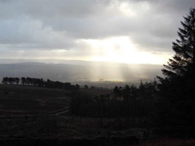
At the road junction, the Bowland Fells appeared in the distance with Beacon Fell, Fairsnape, Parlick, Birkett Fell, Waddington Fell and Longridge Fell all lined up in a splendid panorama.

As I walked into Longridge the dismal sight of traffic jams caused by new developments greeted me. Gloom descended once more.

I won’t use this route again because of the traffic on the roads. I will endeavour to come up with a better alternative for tomorrow’s Social Distancing walk.

Potential viral persons encountered   5.

*****


LONGRIDGE RESERVOIRS.

I’ve had enough of splodging through waterlogged fields so today for my short walk I was happy to keep mainly to tracks and roads. Why not walk around the reservoirs in Longridge? There are basically seven, Dilworth Upper and Lower, Spade Mill 1 and 2, and Alston 1, 2, 3.

Preston originally had water from springs in the Alston area and a reservoir was built in Grimsargh in 1835. The first Upper Dilworth reservoir was built about the same time for water from Longridge Fell. As demand increased water was collected from the Bowland Fells and conducted to Longridge and its Alston [now no3] reservoir completed in 1842. Demand from Preston increased and the next to be constructed was Spade Mill [no 1], along with The Black Bull inn, see later as Corporation Arms. Some years of drought, remember them? lead to the purchase of Alston College on the edge of the village. Demolition of the college allowed a second Alston Reservoir [no 2] to be constructed in 1899. A second smaller Dilworth [lower] was opened in 1906. In the 1930s the aqueducts from Bowland were improved with the drilling of two tunnels, one out at Whitewell and the other through Longridge Fell from Jenkinson’s Farm in Thornley to Spade Mill Reservoir. A third large Alston [now no 1] was constructed about the same time.   The last of the Longridge Reservoirs to be built was Spade Mill [no 2] coming into use in the late 1950s.

That’s a lot of water.

Dilworth Upper.    1835.     24 million gallons.

Alston No 3.           1842.     86 million gallons.

Spade Mill No 1.   1862.    198 million gallons.

Alston No 2.           1899.    183 million gallons.

Dilworth Lower.     1906.        7 million gallons.

Alston No 1.            1931.    259 million gallons.

Spade Mill No 2.     1956.    212 million gallons.

The reservoirs have been under several different authorities, Preston Corporation, North West Water and now United Utilities.

Right, back to my walk, I parked up in upper Longridge and set off around the small Dilworth Reservoirs. immediately the strong Victorian stone architecture was visible …

Just above is the upper reservoir which is often a haven for waterbirds, Great Crested Grebes nested last year.  The lower reservoir has been decommissioned and I was under the impression that the upper was polluted from nitrate wash-off from the fell. Despite this, it is a popular angling spot.

Upper Dilworth with Beacon Fell in the background.

A footpath goes from here through an old quarry, Greenbank, now a housing estate. At the lower side of the quarry is a lake once a fishing spot for local youths. Above the houses is the well-known climbing venue Craig Y Longridge. From up here, there are views across the two Spade Mill Reservoirs and on to Alston. The lane I take goes past the WrittenStone which I’ve previously detailed here.

Walking along the main road I was outside the walls of the Spade Mill no 1 as I arrived at The Corporation Arms, the only inn uniquely owned by a waterboard.

Just past here I detoured up a bridleway to get a better view of Spade Mill No 2 the most modern of the reservoirs. Next, I was walking down to the Alston Reservoirs, both officially off track. The lane continues below the reservoirs and what was No 3 but now is managed as a nature reserve. There are hides to view the water and margins. With my naked eye today I saw very little, it was cold and windy.

Apart from the conversion of No 3 to a wildlife site, the reservoirs have a very sterile environment. There is some restricted fishing but one wonders why they couldn’t be opened up for some watersports. An interesting walk of about 6 miles on a breezy but dry afternoon.

Next up is storm Dennis – the menace.

OUT OF LONGRIDGE.

I wake to bright sunshine but take some time and coffee to get going. The health of two of my best friends is deteriorating; one with heart and kidney failure, the other with cruel dementia. I was talking to them both yesterday and it struck me that it doesn’t seem long since we were out climbing and walking together. So you have caught me in a pensive mood, not at all that  ‘happy new year’ feeling. I should have arranged a walk with one of my other friends for today – to ‘get me out of it’ but now it’s too late, I’ll just have to go myself which is not good for those introspective thoughts but I usually find the combination of sunshine and exercise clears my mind.

I’ve had enough of muddy fields recently so I’m happy to walk on roads for some much-needed exercise after the season’s excesses. Living where I do I’m lucky to be able to walk out my door and ascend a fell, in fact, the most southerly named fell in Britain, Longridge Fell. I’ve done it hundreds of times before. No matter there is always something new or worthwhile.  To start I spot a half dozen partridges running across the road in front of me, is it a covey or a bevy? And then a buzzard on the telegraph wires. After that, I seem to run out of wildlife sitings. Longridge is surrounded by water in the form of reservoirs and I pass the smallest one on my way out of town. Then I walk below the golf course which looks in fine fettle for winter but it must be a struggle in the wind, it is so exposed to the elements.

The road, the old Clitheroe road which kept to high ground, goes up and down towards the New Drop Inn. Few cars pass me. Turning the corner here I am walking in the footsteps of the Romans, this was their way from Ribchester to Carlisle.  The highest point on the road is reached near Cardwell House and looking back Pendle Hill looks as proud as ever. I bump into an old friend taking his dog for some exercise up the fell, we chat about all things local. This is his favourite hill and he’ll have his ashes scattered nearby. Coincidentally this is also one of my favourite viewpoints and my ashes will be here too, I told you I was in a morbid mood.  Years ago I asked a local artist, A Lord, to paint me the view from here over Chipping Vale with the Fairsnape/Totridge ridge in the background.

This painting is one of my prized possessions with its links to a past friend and to this great viewpoint. In the painting are the white iron railings that were a common sight on road corners around here to improve visibility for the motorist. They are slowly disappearing, I’ve always thought they should be listed as unique structures.

The weather was changing, dark rain clouds circling around the hills with the occasional rainbow over Chipping. Soon it was all downhill back to Longridge. Five miles with five hundred feet of ascent in one and a half hours. That’s how you clear your mind. Oh, and I found three good golf balls to boot.

*****

AIN’T NO SUNSHINE.

Ain’t no sunshine today but I still manage a short walk in the rain.

I suppose I’ve become a fair weather walker. I choose my days when I know [hope] the weather is good, like last week. I can afford to be selective. That wasn’t always the case. Many wet weekend climbing trips were spent in a steamy café [Llanberis, Ambleside, Hathersage]  with tea and toast to while away the hours before driving home. Long-distance walks would always throw up a few wet days although I was considered lucky in my choice of a holiday week.

There will be people out walking trails this week, the holiday season is upon us, who have enjoyed the dry hot conditions and now have to continue on the wet days. Variety is the spice of life, or so they say. My thoughts are with them – it is all character building, that’s what I tell my Grandchildren. We’ve all endured a day of soaking weather and yet remember the experience, if not fondly, but with some pride in having survived and enjoyed a pint in the pub that night.

Back to today. The skies are grey and it is raining but I tell myself that I must get some exercise and avoid a depressing day as Bill Withers’ song suggests. A poignant song as always but particularly so at present as one of my best friends is suffering a form of dementia.

I choose my usual ‘fall back on’ stroll around lanes and through the village. The cricket pitch looks dismal and the encroaching housing estate doesn’t help. No match today. Lord’s Lane leads up into the mist and there is no sign of any fell tops. Along the old railway track into John Smith’s Park is dank and dark –  unlike a painting by talented local artist, Emma Lord, I bought last week at Create Longridge Day,  This painting was on a day of light shining through the branches onto the same path I’m walking today.

I’m home, not unduly wet and semi-satisfied I’d made the effort.

*****

As an aside, though it may be connected, one night last week in the hot sweltering weather I was awakened by a bat flying around my bedroom!  It must have entered through my open skylight and now was lost. Concerned for its welfare I opened all my other windows but it persisted in its circular orbits. When it eventually landed I was able to scoop it up in a carton and free it outside. I presume it was a Pipistrel but I’m not sure, it’s not easy to photograph a flying bat with your phone in the middle of the night.  An unusual encounter that lifts one’s spirits.

It’s been a wet Sunday.

*****


SKIPTON TO LONGRIDGE 4 – A sunny Longridge Fell.

Longridge Fell from the south, Kemple End is the steep bit at the right.

Higher Hodder Bridge to Longridge.

JD and I are sat in the bus station at Clitheroe waiting for the Skipton bus to arrive with the pieman on board. The alloted time passes and we wonder if we are in the right place, we circle the area in our car but no sign of him or the bus. The phone call elicits that the bus broke down! We look at each other and as the day is dismal and I lack enthusiasm we drive home  for other pastimes,  ie gardening.

Fast forward 24 hours and we are sat in Clitheroe bus station once again. I must admit the weather was far better today so we hoped the pieman would arrive. He did and within 10 minutes we are parked up at Higher Hodder Bridge at the base of Kemple End, the east end of Longridge Fell. After a stretch by the Hodder we start a fairly easy zigzag ascent of the fell. Behind us were views across the Ribble Valley to Pendle and Waddington Fell. We emerged at the road and stripped down to shirts for the rest of the 1000ft ascent in increasing temperatures.

Higher Hodder Bridge.

Climbing Kemple End, Pendle in the background.

Layers coming off.

A mixture of tracks and paths through the forest where there has been a lot of clearances of late, a magic route opened up in front of us. The lighting seemed to transport us to some alpine approach but there were no snowy peaks above. Familiar tracks head up the fell though in some places wind damaged trees create diversions. We came out of the trees at a well known viewpoint overlooking Bowland, the Three Yorkshire Peaks were in haze.

Magic light amongst the trees.

There is a way through.

More uprooted trees.

That viewpoint.

Our guest from Yorkshire is impressed by the scenery and we eventually arrive at Spire Hill the summit of Longridge Fell at 350m. At the trig point is a man talking on short wave radio as part of the Summits on the Air scheme.  He was mainly concerned with radioing his position although he requested a summit photo. Listening in to his pointless conversation with some unknown person made me think why we climb summits. We were sweating from our exertion, ready for lunch, breathing in the air and enjoying the situation and views particulrly of Chipping Vale and the Bowland Hills. It takes all sorts.

Radio ham.

Well deserved lunch with a little Brexit chat.

We had been climbing steadily all morning but from now it was gently downhill. The view over the Fylde was rather hazy but the sunshine became warmer as the day wore on. There was some unavoidable road walking past the golf club. This now popular venue had humble beginnings as a 9 hole course which was amalgamated with Preston Cycling Club at the beginning of the 20th century. They built an early clubhouse shared with the golfers and as time passed the golf developed and the cyclists moved elsewhere but the badge still remembers the joint beginnings.

Heading down with Parlick and Fairsnape in the distance.

When it all started.

Present day signage.

We took to fields again and entered Longridge via the old railway line used by the stone quarries. We had spent the whole time walking Longridge Fell, about 7miles as the crow flies, hence its name. Cutting through the streets we completed our house to house route from Skipton. Well that’s another of my straight lines accomplished and very enjoyable it has been; beautiful varied scenery, interesting history and good companionship with enough exercise on each occasion to fill a winter’s day. But now Spring is upon us thoughts drift to wider horizons.

*****

SKIPTON TO LONGRIDGE 3 – the two rivers.

Chatburn to Hodder Bridge.

As you may know I’m juggling a couple of routes giving winter walking, the northing SD38 across England with Sir Hugh and this shorter walk with The Pieman between our two towns. We meet up outside Hudson’s Ice Cream Parlour where we finished last time. I’ve enrolled JD [aka Doug] into today’s stroll, The Pieman appears from behind the ice cream cone.

We left the road by the church and followed paths down towards the river. An area popular with dog walkers judging by the number of poo bags hanging in hedges, I’ve given up commenting.

The Ribble was full with last night’s rain and snow melt. We were now on The Ribble Way skirting round the massive Horrocksford complex which produces a significant amount of England’s cement. The first bridge we came to was at West Bradford. After this we entered  a sculpture trail on the outskirts of Clitheroe. I think we missed most of the sculptures but noticed a few. None was outstanding.

After Brungerley Bridge we looked across to the impressive Waddow Hall a 17th century building owned by the Girls Guide Association and nowadays used as a wedding venue.Somewhere along here we passed muddy paddocks and then got sucked into new housing developments, they are everywhere, to arrive back onto the road at the sports centre. In the recreational ground we found a bench to watch the river go by and eat lunch. Edisford Bridge was built, at a former ford, in the 14th century and until 1600 was the only bridge upstream from Preston.

On the far side of the bridge is the eponymous hotel, having eaten we walked on by.

Complicated field paths led across to the complex of buildings at Withgill. All the while Kemple End, the eastern end of Longridge Fell, loomed above us, our onward route for another day.

The scenery improved and the paths became more interesting as we dropped down to the River Hodder.The river was crossed by the Higher Hodder Bridge with its historical boundary markings.This bridge is on our Skipton to Longridge line and from here our route will be up Kemple End and along Longridge Fell. But to finish off today we want to show the Yorkshireman some stunning scenery alongside the Hodder between the bridges.The familiar path undulates above the Hodder in splendid isolation. At one point a cross is seen, it has no inscription and local opinion is that it marks the spot of a drowning.Above us is the Stonyhurst estate and the long established Jesuit College. Down by the river are the remains of bathing houses where pupils changed before a bracing swim.And yet above us are buildings previously used by St. Mary’s Hall, a preparatory school for Stonyhurst College. It was closed in 1970 and converted into high-end living accommodation. There is a connection between Stonyhurst and Tolkien and hence there is a carving of Gandalf, the wizard, in the garden.

All that remained was a stroll alongside the Hodder to the Lower Bridge where the customany diversion was made onto Cromwell’s Bridge.

We had finished for the day. Rather mundane but highly enjoyable.

*****

NORTHING 438. LONGRIDGE TO BARROW [Whalley]

Pendle in all its glory.

A bus runs two hourly back to Longridge from Barrow, there is one at about 5pm.  My bus app says there is one due in 5 minutes, we should be OK.   As we approached we found ourselves in newly developing housing,  we took to the access road only to find it was blocked with that wire fencing erected around building sites. Panic followed as we peered through the fencing at the nearby bus stop. We didn’t have time to burrow Colditz style under the security barrier but with a little lateral thinking we made our escape onto a nearby lane and as we arrived at the road an unidentified bus was approaching. A desperate outstretched hand somehow halted the bus and we clambered on thanking the driver. We were home and dry.

The day had started more sedately with a stroll through housing estates in Longridge until we were level with the quarries at the top of town. The caravan site in the largest quarry was closed for a few weeks and there was no one climbing in the esoteric Craig Y Longridge. Here we left the roads and took to a bridleway below the incongruous ‘chalet’ development that was so controversial when planne, it pales into insignificance with todays developments in the town.The only thing of note was a new seat with an agricultural theme.

Walking on water.

Down the old lane we arrived at ‘The Written Stone’ which I’ve mentioned several times in local blogs.

What I hadn’t noticed before was the typo error where the carver had misspelt stone and added a small o later.  We then spent the morning traversing the southern side of Longridge Fell on paths and tracks between ancient farmsteads crunching through the snow in bright sunshine. One of the first farms, 250year old Hoardsall, has the appearance of years gone by. This morning the farmer was busy splitting logs, his source of fuel, in an outhouse with his black and white cat watching on. We fell into conversation and gleaned a fascinating history of sheep farming in the area. His farm yard was cobbled with local sandstone setts which had been augmented in the past with granite setts removed from Brook Street in Preston. [I knew of an antique  business which purchased old setts, street architecture, pub paraphernalia and red phone boxes etc when Preston was being ‘modernised’] A fascinating encounter which makes me think that these insights should be recorded for posterity.

New Row Cottages in Knowle Green formerly belonged to cotton weavers and are now a peaceful haven away from the main road.

Ahead was a tree topped hillock of unkown origin. Eventually we joined the delightful bridleway alongside Dean Brook into Hurst Green. One of my favourite walks. We lunched on a wall by the Shireburn Almshouses which were first built on Longridge Fell in 1706 but moved and rebuilt in Hurst Green in 1946. The village is closely associated with nearby Stoneyhurst College whose grounds we walked through. Much has been written about this famous Jesuit establishment. https://en.wikipedia.org/wiki/Stonyhurst  All the while a snowy Pendle loomed in the background.

Leaving the grounds we dropped down to cross the River Hodder at the historic border between Yorkshire and Lancashire. You take your life in your hands to view the inscription on the bridge and the nearby ‘Cromwells Bridge’

We did not enjoy the forced road walking into Mitton and were glad to escape into a quieter land leading to the 12th century All Hallows Church. Next door was the stately 17th century Great Mitton Hall. Downhill on the busy road we crossed the River Ribble with more views of an arctic Pendle Hill. This is fantastic Lancashire countryside. Pleasant field paths led us to our debacle with the new housing estate. The best day so far on our SD38 journey.There were signs of spring all along the way.

*****

FURTHER UPDATE ON SHORT WALK OBSTRUCTIONS.

Last June I experienced problems  on one of my regular short walks from home, barbed wire across the path. I reported the obstruction to LCC highway department.  A month later the obstruction had been temporarily removed though no stile provided. Early this month I had an email from the council stating that the fence has been opened up and a gate erected. This morning there was substantial snow and I wasn’t inclined to take the car onto the roads so later in the day, as there was some brightening, I thought it a good idea to do a walk and check the above footpath situation at the same time.

Once off the road I was on virgin snow, nice and crunchy. Surprisingly the first stile which was in good condition had been replaced by a kissing gate. Walking on I could see that the obstructed fence now also had a brand new gate. Problem resolved.

On closer inspection the gate had not been fitted correctly and wouldn’t close so the orange bailing twine was being utilised. Shoddy and no doubt expensive workmanship.

Anyhow I could now proceed with the walk which I continued across fields to Gill Bridge and then quiet back lanes to pass through the grounds of Ferraris Country Hotel. The bad weather had resulted in fewer visitors than usual.https://cdn.ostrovok.ru/t/1024x768/second2/1430170966/852be815eb041e63f83871d98193f8b2.jpg

The sun was making a brief feeble appearance as I walked home past the cricket pitch.

*****

NORTHING 438. INSKIP TO LONGRIDGE.

January 27th.    7 miles.

This is long distance walking in easy stages designed for winter exercise. Todays stage actually finishes in Longridge, my home town, which is convenient for me if not for Sir Hugh who has to travel from Arnside, but it was his idea in the first place. At least today we meet up in the agreed destination, a good start. We are walking by 9.30 on a clear sunny morning with a strong cold wind at our heals. There must have been a lot of rain last night judging by the pools on the road – an ominous sign. We take to footpaths as soon as we can and end up in deep mud similar to where we left off last week. The stiles around Singletons Farm are virtually impassable, blocked by hawthorn, but we push through.Crossing a field we are confronted by the next stile leading into a lake, no way we can go that way so we retreat and hit the minor lane to Cuddy Hill [sounds Scottish] and the well-known Plough Inn. After all the frustrating obstacles I was ready for a drink but of course they hadn’t opened. Eventually we find the onward path and emerge onto a lane which took us over a canal. In the past we have both walked the The Black and White, Lancaster Canal.    but we didn’t recognise the location,

We were on the A6 for a short distance before crossing over onto tracks to end up in fields,  navigational errors had us back tracking to reach Jepps Lane. The A6 seemed like the transition from the flat floodplain of The Fylde to the pleasant countryside of the Ribble Valley. The wind by now had intensified and many of Sir Hugh’s pearls of wisdom were lost. I had never been down the lane to Barton Old Hall before, but it conveniently crossed the motorway for us. The Old Hall was hidden behind trees and the cluster of houses and conversions at the hall were rather depressing.

I think we were deterred from the actual path through the properties, but still found ourselves in rolling countryside alongside the proverbial babbling brooks. Time passed as we weaved our way through the pleasant Lancashire countryside. The Bowland Fells rose in the background and ahead was a glimpse of Longridge Fell.

We passed the stately Goosnargh Lodge, joined some local routes and reached Goosnargh Mill, not the best of conversions.

I was now on home ground and confidently marched across fields finding hidden stiles until we reached one that was in such a dangerous state we had to retreat yet again and find an alternative way. Worse was to come as what had been open fields was divided up by permanent electric fencing, the sort used for equine enclosures, with no regard for any public rights of way. Attempts at crawling under on the wet ground were not pleasant, so we took to dismantling the top wires to step over, there was fortunately no electric current. Reports to LCC  are on their way. A rather sour note towards the end of the day.

He who dares – SAS training.

Just before Longridge we passed Sea View cottages,  and yes you could just about see back to the coast where we had started SD 38.The road into Longridge is now surrounded on all sides by new housing developments, the Fell can just be glimpsed above the roofs. It is no longer the attractive, honest, little town that I moved to all those years ago.

*****

WINTER ARRIVES ON MY DAILY WALK.


The moon was still bright and large while I was having my reviving first coffee, always the best of the day.

Overnight an inch of snow had softly fallen and now in the morning sunshine all was glistening white, time for that short walk before going out for lunch. I try to put in a few miles most days even if it is only my  daily walk cum shopping trip.

Out past the white cricket pitch and up the lane with views to the Bowland Fells, rabbits had been out much sooner than I.

Fields take me onto the toe of Longridge Fell, around the icy reservoir road with views to Beacon Fell.

I arrive for a peep into Craig Y Longridge. Despite the snow the rock was in perfect condition in the sunshine and if I hadn’t other appointments I would have been tempted back later for some bouldering.

I was soon down through the town, a quick supermarket dash and home for a second coffee. Oh and the lunch at The White Bull in Gisburn was excellent, I think I had worked up an appetite.

*****

SKIPTON TO LONGRIDGE 2 – winter sunshine.

Barnoldswick to Chatburn.

Late sunshine under Pendle.

In Gisburn churchyard hidden in the long grass is the grave of Francis Duckworth, 1862 – 1941.  One of my recent diversions has been searching for significant gravestones with the help of a book by Elizabeth Ashworth – Lancashire Who Lies Beneath? and I’d recently found his. He is remembered as the composer of the hymn tune ‘Rimington’. Have a listen –

https://hymnary.org/hymn/SCM/56

We had found a bench in Stoppers Lane for lunch opposite the Rimington Memorial Institute and on a nearby row of cottages I noticed this plaque –


JD [now aka Doug} the Pieman and myself had started outside a Rolls Royce factory in Barnoldswick and wandered indirectly through the mill streets as close as possible to our Skipton to Longridge line. It was a perfect sunny winter’s morning.Until the 1974 local government reorganisation historic ‘Barlick’ was in West Yorkshire, as several of the other villages visited today. The rivalry/frienship between the two roses counties is continued today and highlighted on some benches in town. We spent the morning navigating fields and lanes past both old and renovated farmsteads, through the hamlet of Howgill and into the scattered Rimington village. We were in close proximity to streams which eventually become Swanside Beck that joins the Ribble near Sawley.

To the northeast were Ingleborough and Penyghent and to the northwest Longridge Fell, Beacon Fell and Fairsnape.

After lunch using back lanes we seemed to avoid one of Rimington’s famous features – Cosgrove’s fashion shop. We dropped down to Ings Beck and Downham Mill.Soon the Ings Beck Joined Swanside Beck and we were alongside the familiar packhorse bridge. The next bridge we were on was that high one crossing the A59…… from where there was our last view of distant Ingleborough before we stroll down into Chatburn before the sun sets.

*****

NORTHING 438. COAST TO COAST.

An email dropped into my box –

What about:
Longridge to the Sea – Eastwards.
Following the OS line 38. I have had a quick look and it appears more or less possible. Straight line 104 miles and interesting – certainly a lot of new territory for me.  Conrad. 
[Sir Hugh to those familiar with this blog]

I ignored this for a day or so, thinking it was too ambitious, and I had better things to do; like finish off the GR131 in the Canary Islands and complete my protracted Land’s End to John o’Groats. But the idea gnawed at the back of my mind, and I foolishly looked up the maps. The SD 38 Northing in question runs virtually past my house. It becomes the SE38 and the TA38 further east, thus is better described as 438 Northing. My mind was in action now, why not start on the west coast and finish on the east, 122 straight miles Blackpool to Aldbrough.

A bit of a pipe dream. Better do some gardening.

SKIPTON TO LONGRIDGE 1 – another straight line.

Skipton to Barnoldswick.Following on from the success of the straight line from Longridge to Arnside completed with Sir Hugh at the end of last year I have persuadedthe piemana resident of Skipton to undertake a similar scheme between our respective abodes.

The Pieman.

He is a lifelong friend, possibly blood related though I tend to ignore that, with whom I’ve shared many backpacking trips throughout Europe but recently we have not been able to meet up as much as required. So this was a good opportunity to get 2019 off on a better note. Thus I was drinking coffee in his house in Skipton early this morning before setting off on what could only be described as a drab day.

My local guide takes us across Aireville Park, where I used to play as a child, over the Leeds Liverpool Canal and out of town through an industrial estate with some interesting relics awaiting restoration.

Airedale Park.

We crept under a main road and crossed the placid River Aire on an old track into Carleton. This essential bridge for our route was just within the mile either side of our arbitrary straight line  The C19 mill in the village was originally for cotton-spinning but I remember buying carpets there in the 70s, apparently it is now luxury apartments.

Carleton.

Today we didn’t visit the village but took to unmarked footpaths through green drumlin fields. I have to concede that satellite tracking maps were a great help in navigating this section. We were going parallel to a disused railway [Skipton to Colne] and eventually we found ourselves walking along it for convenience until stopped by vegetation.Possibly we touched on a Roman Road leading to Elslack where there was a fort. Our priority was to find a picnic bench and there right in the middle of the hamlet was one in some sort of memorial garden. Having put his instant coffee powder into a cup he looked for the flask containing the hot water, unfortunately it was on the worktop back in Skipton. I had hot apple tea in my flask so he ended up with a strange brew.

We walked past the C15 Elsack Hall but at a discreet distance and then along the abandoned railway into Thornton-in-Craven joining the Pennine Way for a short stretch. The village has interesting old houses but no shop or pub and the heavy traffic deterred us from lingering.

Tree planted for the Coronation of Queen Elizabeth.

?Millenium Clock.

On the edge of the village are Almshouses built for poor women, there is not much of that charity evident today.

By the church a sign guided us to a Holy Well in the grounds, dating from Saxon times it is covered by an octagonal structure erected in 1764 by the rector.

On a short stretch of golf course we joined The Pendle Way. It weaved around a church and graveyard where every grave was decorated with flowers, presumably from Christmas.

Rolls Royce have a large presence in Barnoldswick and we passed one of their factories before joining the Leeds – Liverpool Canal for the final stretch into town. My overall impression today was of green fields and a rich historical background.

*****

AROUND LONGRIDGE TO SEE WHAT’S NEW.

I was drinking coffee and debating whether to go for a stroll or even rescue my bike from the garage for a ride when JD phoned suggesting a walk, we chose a short one circumnavigating the village as I was interested in the changes taking place. On reflection if we’d had more time we should have climbed onto the fells to take advantage of the perfect weather.

Anyone who knows Longridge will be aware of the rash of indiscriminate housing developments. These are immediately obvious from the road where for some reason the football club have sold off a field within their grounds, previously used for youth training, for six houses. Already this is creating problems on match days as now their parking is limited there is dangerous parking on both sides of the busy road and footways, time will tell.  Across the road the cricket pitch is being surrounded by development. I was surprised to see this strange buiding practice…

Climbing up through the estate onto Higher Road was an alteration of a different sort, the local Thai restaurant’s entrance porch has been destroyed by drunken drivers badly affecting trade over the Xmas period.

There were however peaceful views from up here over the Spade Mill Reservoirs. The little the bridleway past the reservoirs is popular with dog walkers and leads onto Alston Lane. Once across we followed a farm lane and found our way into fields with occasional waymarkers, so we only lost our way once heading down to a bridge across a beck. The next farm, Alston Lodge, was a mud bath.

The path weaves its way between the Alston Reservoirs, built for Preston as it increased rapidly in size. A large group of Canada Geese had descended looking for food. Alongside the last stretch of water a wetland reserve has been created and there are hides to observe the birds. Today we saw mainly Mallards!

At the end of Pinfold Lane onto the main road all is changing with a large housing development on its north side and unfortunately a long stretch of hedging has been unnecessarily removed. Fortunately our onward footpath bypasses the development, for how long?  Mardale playing fields give us a bench for refreshments before we cross the old railway line into Shay Lane industrial area. An old path follows a small stream where one used to hop across on stones but recently a wooden bridge has appeared.  Green Nook Lane is usualy quiet but at he end are more new houses on the left and then even more being built across the road and guess what – an Aldi has arrived.

Round the corner is Halfpenny Lane whose fields will all be built on before my next walk round our previously lovely little community. So a day where the negatives outweighed the positives I think.

*****

THE WAY OF THE CROW. Second day, Bleasdale to Arbour, Calder Valley.

JD seemed worried when I described the next leg of our straight line way – “it is extremely rough going, the game keepers are unfriendly and there are rumours of a wild rhinoceros”. Despite all that he agreed to join us on his recommended shortened version. The picture above was taken from his house when I picked him up in the morning, The Bleasdale Fells which we had to cross are to the left of the higher Fairsnape group. Beacon Fell is far left.

The car park at Bleasdale Church was busy with Sunday worshippers.

It was a glorious sunny morning as we used field paths into the heart of Bleasdale discussing our individual Saturday night’s exploits, I probably had the largest hangover, Sir Hugh had been consructing a cat flap and JD entertaing his family.

Donning extra layers when we realised how cold it was.

No that’s not the rhino but pretty scary anyhow.

After the isolated Hazelhurst Farm we found the beginnings of a land rover track that would, via a series of zigzags, take us steeply into the open access area and onto the fell top. We puffed our way up with frequent stops to admire the views over the nearby Fairsnape/Parlick fells with Bleasdale and  the Fylde below. Surprisingly and fortunately another quad track led to the remote trig point, 429m, of Hazelhutst Fell. We are on grouse shooting moors up here and much has been written about the persecution of other wildlife in this vicinity to try to promote the shooting fraternity. Whatever one’s opinions about grouse shooting I am strongly against the wilful and unlawful killing of our protected species. On this stretch of the walk we came across several loaded Fenn Traps which are legally only allowed for stoat trapping [killing] but are known to trap other species. These are lethal looking spring-loaded traps which could almost take the tip off your walking pole.

From the trig point there were hazy views across Morecambe Bay to Black Combe and Barrow. Taking a compass bearing we set off across the heather in a NNW direction and fortunately found another quad bike track taking us down past shooting butts so avoiding all the heavy going. After what I’ve said about the grouse shooting land owners we were thankful for their tracks. The final descent was vertiginous. The surroundings were reminiscent of a Scottish Glen and we found the bridge over the Calder to the Victorian shooting cabin of Arbour. This must be one of the best kept secrets of Lancashire.

We found a sheltered spot out of the cold east wind for lunch. There were no windows into the shooting lodge to see the rhinoceros head. The story goes that a rhino escaped from a train near Garstang and had to be shot, it’s trophy head being mounted in the lodge.

By now all the excitement was over and we had an easy walk out on the track alongside the River Calder.  We were back at Sir Hugh’s car much sooner than we’d planned because of those good moorland tracks. We will have to walk back in next time to rejoin our line.

*****


THE WAY OF THE CROW. First day, Longridge to Bleasdale.

I was apprehensive, walking in a straight line as possible would take us on unfrequented paths, would the way be feasible. We left the village down overgrown Gypsy Lane and shortly after found a gate secured by a cord, a veritable Gordian Knot. Out came Sir Hugh’s, I’ll blame him, Swiss Army Knife and we were through.

‘Gypsy Lane’

We passed the ponds, ‘figure of eight’ where my children used to go fishing without much success but I’m sure they had an adventure away from parental supervision – they never drowned so I must have been doing something right.

The next farm-yard, where I’d previously climbed walls to escape, was now well signed and we even had a resident directing us to the hidden stile ahead though the accompanying foot plank, couldn’t call it a bridge, didn’t inspire confidence.

The slippery plank.

We reached a farm gate on a public footpath which was securely padlocked, no Swiss Army knife could cope, but as if on cue a lady drove up in her battered pick-up and opened up for us. Remonstrating about obstructed footpaths didn’t seem to be appropriate. All was pleasant rural scenery with scattered farms, some in better condition than others.

The next problem was of our creation, contentedly walking along the tiny River Loud we were almost in someone’s back garden when we realised we’d missed our path but fortunately a gate allowed our escape onto the road.

The infant Loud.

Things improved as we headed closer towards the Bowland Hills and Bleasdale. We passed the small rural Bleasdale School and headed for the church where our car was parked. We were last here in gale force Ali. A group of fell runners were just setting off for a quick few miles and we exchanged pleasantries. Walkers, climbers , cyclists, runners tend to have a common background.

Is that an Ofsted verdict?

We had completed the first leg of our project with very little deviation from the straight and narrow and to be honest no serious obstacles except a lot of slippery stiles. Our way ahead over Hazelhurst Fell could be seen, the fell runner is pointing the way, but will there be any paths?

Yet another slippery stile.

***** 

THE WAY OF THE CROW. LONGRIDGE TO ARNSIDE.

My good friend Sir Hugh  [http://conradwalks.blogspot.com/ ] inhabits that lovely village Arnside whereas I have to put up with the gross overdevelopment of Longridge. For the last few winters we have had projects to keep us active in the shorter days. He has emailed once or twice with suggestions for this year but nothing has struck me as original, boringly I seem to have walked most of the Long Distance Paths in the NW. I came up with a counter suggestion – why don’t we draw a straight line between our houses and follow it as closely as possible. I know this idea has been used before, particularly successfully  by Nic Crane on his straight line Two Degrees West journey from Berwick-on-Tweed to The Isle of Purbeck. I seem to remember he gave himself  a kilometre leeway either side but had a lot of media support, I wonder if we could be even stricter. True to form Sir High has taken the bait and the line has been drawn.

It is the wrong time of year for backpacking so we will split the route into day walks. The distance as the crow flies is 26.5 miles but we will be lucky to keep it under 35 miles. No rules except keeping as close to the line as possible preferably on footpaths or quiet lanes, legal ground or not. There are some obvious obstacles in the way – the fells of Bleasdale, the Rivers Wyre and Lune, Quernmore Hall Estate and the M6. It will be a challenge overcoming them, lets get started.

ALSTON – LOOPING THE LOOP.

As the crow flies it is 4 miles from Longridge to Samlesbury, where BAE Systems [previously British Aerospace] is based, however the River Ribble is only bridged at Ribchester or Preston both giving a far longer journey. A friend of mine would in summer take a short cut down Alston Lane and ford the river with his bike straight to work. Today I tried to identify the place he crossed but of course there was a lot of water running, I think the above photo is roughly the spot and I shall investigate further next summer.

Anyhow back to the beginning. Lethargy and other pressing problems these last few days have kept me in; it is easy to slip into this mood when the clocks change and Winter approaches, that is the reason I normally go off to sunnier climes. I planned this route last night and set the alarm so I was committed to venture forth. There was a window in the weather so timing was crucial which still gave me a leisurely breakfast. I was parked up at 10am,  My clockwise circuit ment walking on the main road for a few hundred metres alongside the ghastly development of new houses, all dumper trucks and lorries. Why have they seen fit to obliterate over a 100m of hedging to gain access to the fields? This did not put me in a good mood.

Thankfully I soon turned down Pinfold Lane  [pinfold – a pound for stray animals] and looked into the adjacent field where I found the base of the ancient Bolton Fold Cross which I’d not noticed before.

There were a couple with binoculars in the hides overlooking the wetlands adjoining the lane. I couldn’t see anything of interest except a long view to St. Lawrence’s Church and the prominent Dog Inn in Longridge.

Over towards Pendle there were darker clouds contrasting with the sunlit autumn foliage. Lanes linked little farms, most now converted into modern residences. A lot has changed since I last came this way. I bumped into the father of climbing brothers from the past and we chatted about old times. A farmer further on was more expressive [forthright as only farmers can be] about the world’s problems. All in a day’s walk. Hereabouts The Ribble Way crossed my path heading towards Ribchester on the line of a Roman road, of which there is little evidence.

Not all has been beautified.


This guy means business.

Dropping down fields I seemed to be heading to a cul-de-sac but there in the corner was a stile and a footbridge over the stream, all very delightful.


“falling leaves hide the path so quietly”
John Bailey

At last the object of my walk, the River Ribble, was glimpsed through the trees below. The river here makes a looping curve around flat fields with an escarpment on the south side. Ducks were floating in groups and when disturbed fired off in all directions like some of this weeks explosives. I do not understand why the Ribble Way doesn’t follow this delightful stretch of rural Lancashire.

Once past the ‘ford’ I was looking for C17th Old Alston Hall but only had a glimpse of it across private gardens. Higher up the lane is the C19th gothic Alston Hall which was used as an education centre by Lanc’s County Council until being sold to a private buyer. I won’t add fuel to the rumours of its recent extensive fire and plans for redevelopment. The observatory run by the University seems unaffected.

Old Alston Hall.

New Alston Hall and observatories.

It was a relaxing walk up Alston Lane, noticing all the recent residential conversions, back to my car. As I reached it the rain started in earnest – it’s all about timing.

*****

Possible ford in red.


‘BOWLANDCLIMBER’ – WHAT CLIMBER?

A little inspiration.

Anyone who has been following my posts this year or anyone searching ‘climbing’ will have noticed there has been no climbing. For various reasons I haven’t done a route for the first time in 40 – 50 years.* My climbing friends probably think I’ve died. This was brought home to me the other day when I happened to be in south Preston with one of my now ‘retired’ climbing partners.

I think we are near Denham Quarry” I mentioned,  “let’s go and have a look in

Easier said than done as we drove arround in a maze of forgotten narrow lanes and kept crossing and recrossing the motorway. All of a sudden Holt Lane appeared and the name rang a bell, sure enough a short distance down the lane the familiar car park appeared and there was the quarry.

And there was that striking clean quarry face with the obvious groove line of ‘Mohammed’

In we went and peered up the classic groove which had a few chalk marks on it. When did we last climb this – one for the history books. Its real title is, wait for it, Mohammed the Mad Monk of Moorside Home for Mental Misfits. What’s that all about?

My friend is suffering a cruel form of dementia and has lost her speech but on seeing Mohammed excitedly started making climbing movements with her arms. A wonderful moment.

Moving right under the main face other routes were recalled, most of them scary on small holds and poor gear. We had survived.

And there was that deep pool, with unknown monsters in its depths, and the lovely soloable Splash Arete above it. Memories.

Back home I reflected that I probably would be struggling on those routes now but my enthusiasm was fired and on a sunny afternoon I’m up at Craig y Longridge traversing around on familiar territory at the easy far end. The crag is bathed in warm sunshine and I’m the only one here so I can laze around as much as possible. I can do the moves but my hands have become soft and soon my skin is protesting, enough.

* PS. The following morning I had a brief visit up to Kemple End and soloed a couple of short routes to break the year’s zero statistics.


HEDGEROW FRUITS.

After the rigours of last week’s walk in the gales I’ve returned to my usual stroll around Longridge.

I was very aware of the fruits in the hedges as I walked up the lane to the farm. The best of the blackberries have gone but I started to count others and wondered about their edibility and uses.

Hawthorn.  [Cretaegus monogyna]                                                                                  

Very prominent were the red berries of the Hawthorn bushes. Apparently the berries contain potent antioxidants and have been used in herbal remedies for heart problems. Leaving that aside I have found some recipes for jelly and tea, but I’m not convinced as yet.


Rose Hips.                                                                                                                                                                                                           

Scrambling through the hedges were rose bushes with their characteristic red hips at this time of year. Now I know these do make a good jelly and also tea. The itchy seeds need to be removed first and apparently they are best after the first frost.


Rowan, Mountain Ash. [Sorbus aucuparia]

                                                                  
I’ve never before considered whether Rowan berries were edible but reading up about them shows they are, again mainly in jellies or jams.


Elder. [Sambucus nigra]

In past years I’ve made elderflower cordial but not used the berries. They can me used for wine making and also in pies and crumbles.


Blackthorn Sloes. [Prunus spinosa]

This year seems to have been good for the sloes on the blackthorn which grow commonly round here. I think their main use is for flavouring gin and other spirits.

So a short walk brought several possibilities of hedgerow fare, I will research a few recipes in more detail and return for some Autumnal pickings.