A RURAL RAMBLE FROM BASHALL EAVES.

28 years ago I remember a footpath above the River Hodder coming to an abrupt stop where a bridge was falling down. My son Chris and I were on a backpacking trip around the old Lancashire boundary. We had left Mossley, East of Manchester, and worked our way through high Pennine country, Pendle, Ribble Valley, and now we were heading north through Bowland towards Arnside. After getting through the no access, closed and danger barriers we balanced precariously across crumbling masonry high above a stream and carried on our way. Do I have a photo somewhere of that day?  I often wondered what happened to that bridge above Mill Brook. Today I set off to find out.

I parked next to the village hall in Bashall Eaves and set off along a farm track to Mason Green Farm. This turned out to be one of those almost industrial sized complexes. By chance I found a way around it and across fields, full of cows, in the right direction towards Agden Farm which seemed to be a Land Rover hospital. Numerous varieties of the marque were lined up in various states of repair, from a barn there were sounds of restoration.

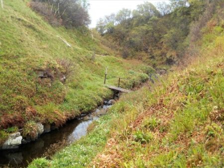
The overgrown path dropped into a gully, the first of many today, and climbed out steeply on recently installed steps. Somebody must come here. 
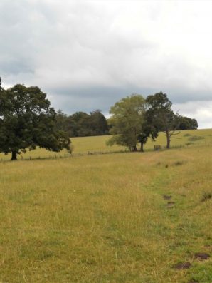
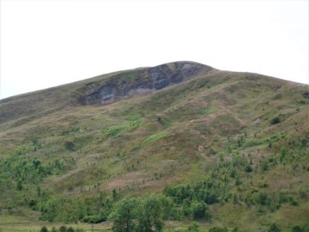
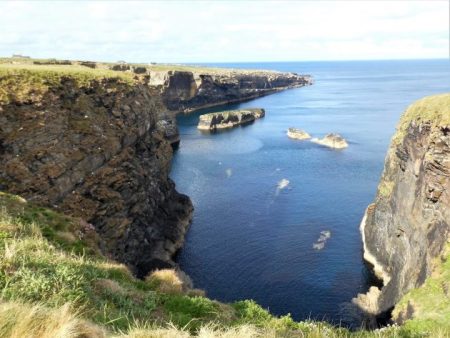
I was now in pastures surrounded by all the familiar fells, Pendle, Longridge Fell and the Fairsnape group. I disturbed a few deer as I dropped into the next gully in Paper Mill Woods. This steep and rather slippery descent took me onto the banks of the River Hodder, full from the last few days’ rain. This is about the only access to the Hodder between Doeford Bridge upstream to Higher Hodder Bridge below. It makes me think that I must be on The Hodder Way a route devised by Clitheroe Ramblers and one I walked in recent times – I have no recollection of this demanding stage.  There was no bridge across the stream but it was no problem to hop across.

Climbing away from the river I pass three magnificent oaks. In the next field of long grass, my only objective is an ash tree on the horizon. 
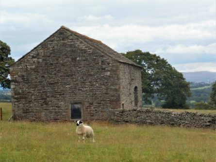
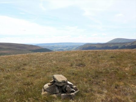
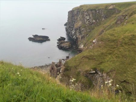
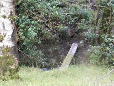
Then it is down once more into woods and a difficult descent of a bluff to reach that bridge from years ago, now converted to a wooden structure spanning the stone abutments. There are references to Roman times but I think that is unlikely even though they passed by quite closely. This is a deep ravine, Mill Brook, and the new wooden bridge, rebuilt in 1997, is more impressive than in the photo.

A vague path climbed up through the woods to emerge into fields with open views of the fells. These were crossed and a final dip overcome to reach a track which follows a Roman road, Ribchester to Kirkby Lonsdale. It had taken me two hours to cover three miles and I was ready for a break and a snack.

Onwards I followed the lane to Lees House Farm, now supporting several developments. It’s called diversification. 
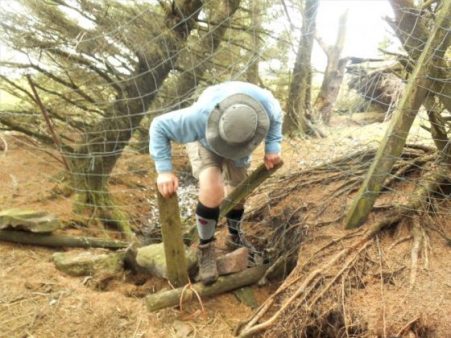
Steep paths lead down to a stream, Mill Brook once again.  Coming up the other side into an overgrown field was not easy if there was a path I didn’t find it.

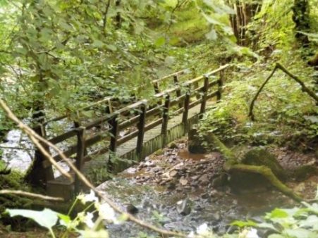
From here to Micklehurst Farm was straightforward though I managed to herd a lot of sheep in front of me. This morning it had been all cows and now sheep everywhere. Barking dogs, thankfully chained, followed my progress through the farmyard. I’ve passed the road end to Micklehurst Farm many times, I think they are distant relations,  I never realised how far off the road they are.

On the corner is one of the entrances to Browsholme Hall, South Lodge, I sneaked a photo of the gatehouse and cottage.

Now I was onto little-used roads through woodlands some of which are described as nature reserves. I met a couple leisurely ambling down the lane, they had been out birdwatching.

Further on an old Alvis Speed was parked up. It was in fantastic condition. The owner working in a field nearby was obviously proud of the vehicle,1932,  – “all original bodywork”. He admitted that the engine wasn’t firing correctly, hence the bonnet was up for tinkering.

I continued down the lane to reach Saddle Bridge which I mentioned in a recent post.  It is always good to look at things from a different angle and I can’t resist a photo of a packhorse bridge.

Returning up the path, Rugglesmire is passed, I trespassed a little to try and see the grade II farmhouse.

Into the hamlet of Bashall Eaves, a few cottages with evocative names – The Old School House, The Vicarage, The Old Forge, The Post Office etc.

The Old Forge.

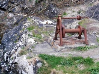
There is also an old Lancashire Cheese press.

Just down the lane is The Red Pump, now a thriving inn/restaurant, but it has a dark history. In 1934 a farmer, Jim Dawson, was shot whilst walking home from the Edisford Bridge Inn at Clitheroe and died later of his wounds. Investigations were hampered by a “wall of silence” from the villagers and the mystery has never been solved. There is talk of ghosts…..

I usually show a map of my wanderings below and I would suggest that any local readers of my posts try this unknown area. The first half of the walk is particularly scenic and interesting – the best of rural Lancashire, and the paths could with a bit more footfall.

*****


AIN’T NO SUNSHINE.

Ain’t no sunshine today but I still manage a short walk in the rain.

I suppose I’ve become a fair weather walker. I choose my days when I know [hope] the weather is good, like last week. I can afford to be selective. That wasn’t always the case. Many wet weekend climbing trips were spent in a steamy café [Llanberis, Ambleside, Hathersage]  with tea and toast to while away the hours before driving home. Long-distance walks would always throw up a few wet days although I was considered lucky in my choice of a holiday week.

There will be people out walking trails this week, the holiday season is upon us, who have enjoyed the dry hot conditions and now have to continue on the wet days. Variety is the spice of life, or so they say. My thoughts are with them – it is all character building, that’s what I tell my Grandchildren. We’ve all endured a day of soaking weather and yet remember the experience, if not fondly, but with some pride in having survived and enjoyed a pint in the pub that night.

Back to today. The skies are grey and it is raining but I tell myself that I must get some exercise and avoid a depressing day as Bill Withers’ song suggests. A poignant song as always but particularly so at present as one of my best friends is suffering a form of dementia.

I choose my usual ‘fall back on’ stroll around lanes and through the village. The cricket pitch looks dismal and the encroaching housing estate doesn’t help. No match today. Lord’s Lane leads up into the mist and there is no sign of any fell tops. Along the old railway track into John Smith’s Park is dank and dark –  unlike a painting by talented local artist, Emma Lord, I bought last week at Create Longridge Day,  This painting was on a day of light shining through the branches onto the same path I’m walking today.

I’m home, not unduly wet and semi-satisfied I’d made the effort.

*****

As an aside, though it may be connected, one night last week in the hot sweltering weather I was awakened by a bat flying around my bedroom!  It must have entered through my open skylight and now was lost. Concerned for its welfare I opened all my other windows but it persisted in its circular orbits. When it eventually landed I was able to scoop it up in a carton and free it outside. I presume it was a Pipistrel but I’m not sure, it’s not easy to photograph a flying bat with your phone in the middle of the night.  An unusual encounter that lifts one’s spirits.

It’s been a wet Sunday.

*****


A HISTORICAL FOLLOW-UP – AROUND WADDINGTON.

A comment from Sir Hugh on my last post, – ‘You seem to have an endless supply of walks full of historical interest.’ made me realise that there is so much history embedded in walking the rural ways of Lancashire. I was intrigued by the part played by Henry VI in the War of the Roses and his subsequent hiding out in our part of Lancashire, the internet giving a version of history at your fingertips. Having been in safekeeping at Bolton Hall, Bolton-by-Bowland he escapes to Waddington Hall. Whilst staying here in 1465 he is betrayed and the Yorkist Talbots from Bashall Hall come after him but he manages to escape down secret stairs only to be caught at the Hipping [Stepping] Stones over the Ribble at Brungerley. He ended up in the Tower of London. So there are quite a few places to visit on today’s walk.

When I parked up on the lane at  Backridge there was mist in the Ribble Valley, Pendle was hiding but the castle in Clitheroe was visible. That was where I was heading and a clear path was discernible through the grass so without any thought or effort I’d arrived at Edisford Bridge and its eponymous Inn.

Tucked away behind a hedge is Edisford Hall of which I was previously unaware and today unable to get a good view of. The hall was apparently the site of a leper colony back in the 13thC. More history denied to the majority, the rich and powerful tend to keep their wealth and property hidden. I cannot deny them their privacy though, an ongoing theme in this post.

Edisford Bridge is medieval and the original ribs can be seen under some of the arches. The inscription on the parapet reminds one of the previous boundaries. The surrounding fields were the scene of a vicious battle [they all were] 900 years ago, but today all was tranquil with holidaymakers enjoying the sunshine on the banks of the Ribble.

I always find the route of the Ribble Way difficult to follow through this edge of Clitheroe. There are open spaces [for how long] but nothing is waymarked, then you are passing old cottages before being sucked into a modern housing estate, the likes of Kingfisher Way and Heron Mews.    Out past allotments the river is gained and followed to Brungerley. Last night’s thunderstorms had put more power into the water at a weir. Across from here one could see on the far bank Waddow Hall, idyllically situated above the river. An old house built in Tudor times by the Tempest family but modified by Jacobean additions.

Further on a family were preparing for a roasting and hi jinks in the river just before the bridge – ‘Brits on holiday’. Hottest day of the year?

Brungerley Bridge was built in the early 19th C, It was at the stepping stones here in the past that King Henry VI was captured. A steep stile climbs onto it, now with the obligatory safety rail.

Over the bridge a path is found into the grounds of Waddow Hall, unfortunately it goes round the back of the buildings. Waddow was bought by the Girl Guides Association in 1928 and it keeps its secrets well hidden, but not their exciting climbing tower which I sneaked a blurry picture of, sorry.

Coming out of the grounds a quiet road winds into Waddington 3/4 mile away. I know this village fairly well from eating in the three public houses and wandering around the church. The main street has a stream running down the middle with attractive and well-kept memorial gardens. For a short time in 1990 it became Granada’s “The Television Village” with its own broadcasts from the village hall.

I knew nothing of Waddington Hall, hidden behind high walls in the centre of the village, its origins going back to the 12thC. It was restored in 1901 by the Waddington family. It was here Henry VI attempted to escape from Yorkist followers.

Up the road is a long-standing café with an unusual frontage of metal posts, their famous pies were cooling off in the kitchen window – another time.

The prominent church is unusually dedicated to St. Helen. the tower is the oldest part from 1501. Inside there are some intricate wooden details. Nearby are the village stocks.

But by now the Lower Buck Inn was beckoning, and I succumbed to a pint of the finest Bowland Brewery’s Blonde Ale. They even allowed me to eat my own sandwiches in the beer garden. This is a great traditional village inn run by the same family for years. Try it sometime, even the dogs have their own brew.

Refreshed I found a hidden path, undoubtedly ancient judging by the clapper bridge, leading out of the village and into open fields with views opening up of Pendle, down to the Ribble Valley at Whalley and round to Longridge Fell. I passed in front of the impressive Colthurst Hall for which I can find no information, although there is A King Henry’s Grove nearby on the map.

An old bridleway leaving the road at Braddup House, Whinny Lane, was marked on the map and I decided to follow it up the fell to an area I hadn’t been to for ages. This was at the base of Waddington Fell which I had explored whilst trying to link up paths for my Longridge Skyline Walk, LSW.  It was good to be out in the high country again and I followed that route all the way back to Backridge.

Up here I was surrounded by hills, Waddington Fell, Pendle and Longridge Fell all felt within touching distance, time for a panoramic shot including all three.

On the way back I passed Talbot Bridge with its date stone obliterated by moss and age. 

The house above the bridge was originally a pub, The Woolpack giving an idea of the passing trade. Next door a Swiss-like house has appeared since my last visit, very twee.

My next point of call was the more graceful Saddle Bridge, 17thC but rebuilt last century, over Bashall Beck which has come down from Talbot Bridge. This packhorse bridge is also known as Fairy Bridge from a local legend.

Soon I was on a familiar track passing the intriguing Bashall Hall. This extensive building dates from the 16thC but has had many changes since in different stiles. It hides behind high garden walls but I managed a few more views today.  

It was from this house that the Talbots set out to capture King Henry VI. So I’ve come full circle on what has been an outstanding walk for historical interest and the best Lancashire scenery.

*****

HISTORIC BOLTON-BY-BOWLAND.


A rambling afternoon.

The village of Bolton-by-Bowland lies in the SE of The Forest of Bowland bordering onto the Ribble Valley.  Until 1974 it was part of the West Riding of Yorkshire and indeed the surrounding area has a feel of the Yorkshire Dales, its history goes way back into medieval times. The Pudsay family were prominently involved with the village, its church and nearby Bolton Hall [demolished in the 1950s, more of that later.]

I started my walk today at the upper green with the Old Courthouse and village school.  [Frontispiece above]    Further up the lane I entered fields leading up and over to the hamlet of Fooden. There were mature parkland trees and here and there evidence, dykes, of old field patterns, these were quite common throughout today’s walk. As I crested the raise I was surprised to see dozens of men wandering the fields with metal detectors and little shovels, it turned out to be an organised group search. One find already was a diamond ring but they were mainly unearthing modern-day coins.

  Entering the small hamlet I met a lady resident excitedly trying to position a weather vein, incorporating a deer, bought at Tatton Garden Festival last week, on her property.  Her husband seemed long-suffering. The further conversation discussed the nearby Grade II* hall building, now empty after the owner died a couple of years ago, its adjacent sulphur spa and the attractive Grade II* cottage with dovecote across the way. By the time I’d finished exploring the weather vain was up and running. What a delightful place to live.

I found a path leading above the River Ribble. Below out of sight was the limestone Rainsber Scar, named in one section Pudsay’s Leap where allegedly a 16thC William Pudsay [from Bolton Hall] leapt on his horse to avoid capture for forging his own silver coins. I did see a herd of Deer on the far bank which judging by their spots may have been Sika.

I was heading for Bolton Mews the remains of Bolton Hall estate converted into private dwellings. One historical note is that King Henry VIth stayed here with Sir Ralph in 1464 at the time of the War of the Roses. Apparently, his divining skills discovered a spring now preserved as King Henry’s Well. Most of the estate is now out of bounds but the covered well can be seen over a wall.

Having circumvented the grounds of the hall I dropped down to cross a footbridge at an old ford on Skirden Beck.  The fields further on to the next footbridge were impassible with maize so I took a short cut fording the low Holden Beck to climb up to the road directly in front of Bolton Peel. This is another interesting house, 17th century with mullioned windows and a fine porch. In front of the building is a preaching cross. The base is ancient, one of four in the area, but the cross is 19th C. The Peel family were early Lancashire industrialists and gave the country a PM in 1841, we are getting a new one tomorrow!

After a fraught but thankfully short stretch on the busy road a fingerpost pointed me into fields leading to the not so historic Hague Farm. I had a friendly, if noisy, greeting from their labrador. Upwards to Rodhill Gate where I joined a sunken bridleway, an old drove lane,  going steeply up the hill. At the top views broke out of a moody Pendle Hill, the Yorkshire hills towards Skipton and to the north Craven Hills with Pen-y-Ghent proudly in the distance. A splendid spot for a late lunch.

A beeline through fields led to Lower Laithe, an isolated barn. Then it was down into the hamlet of Holden. Braxup House was outstanding with its date stone and unique Yorkshire upper windows.

Across the road was the busy Holden Clough Nursery. I frequently visited here when establishing my own garden 40years ago, what a different place then with the owner Peter Foley searching chaotic nursery beds for a plant of your choice,  Now all is changed, son John has revitalised the nursery into a ‘garden centre’ but still with an emphasis on plants. I had no money on me for a cuppa in their cafe.

A strange narrow stepped stile in a wall leads out of the village. I’m heading for 17thC Hungrill farm across the fields. On arrival, the nearby barn conversion takes my attention. A forded lane takes one into a large garden area in front of the impressive building. Several expensive cars litter the forecourt. Obviously private grounds not for me. I slink around the back on a stony track. This leads to fields with no obvious path or waymarks. I think I was distracted by all the wealth on show that I wandered into the wrong fields, waded into small streams, climbed barbed wire fences before coming out onto a road. A right ramble.

Unexpectedly in front of me was a gate leading into a field by the Skirden Beck running down inro B-by-B at the bridge where I was relieved to arrive back unscathed.

I still had time to look around the village at its fine houses and lower green with a stone cross.

Higher was the parish church of St. Peter and St. Paul, rebuilt in the 15th century by Ralph Pudsay. Inside I knew was a remarkable memorial stone to Sir Ralph, a large slab of limestone engraved with images of himself. three wives and twenty-five children!

That was a well-spent afternoon with some lovely buildings to be viewed as well as the surrounding scenery. I was surprised at the underuse of footpaths in a popular area with good waymarking on the whole.

*****


TOTRIDGE FELL, BOWLAND.

 Last night after a bouldering session at Craig y Longridge I drove up the fell and took in the familiar view over Chipping Vale to the Bowland Hills. In front of me were the Fairsnape, Wolf, Saddle, Burnslack and Totridge Fells. How many times have I photographed this scene?  I’ve not been on the easterly of these for several years so there and then I decided on a full traverse of the range today. For every 100 visitors to Fairsnape there is probably only one on Totridge.

I can’t explain why I sat in bed with a couple of coffees delaying my departure. Sloth had taken control and it was with a great deal of difficulty that I finally emerged and started the walk at 11am. By then I realised a full traverse and return of 13 miles or so was impractical and I opted for a shorter 9miles from Saddle End, missing out Fairsnape. The heat of the last few days was diminished by a westerly breeze. Old tracks rise up from Saddle End farm and soon the open moor is reached. A steady metronomic pace is tapped out by my walking poles as I gain ground. There is not a soul in sight.

Saddle End Farm and fell.

On the 26th March 1962 three siblings left home and travelled by bus to Chipping and
walked over the fells, maybe to Langden Castle, on their return over Saddle Fell they were caught in a blizzard which resulted in the two brothers losing their lives due to hypothermia. Their sister survived to raise the alarm at Saddle End Farm. There was no Mountain Rescue Team in the area at that time so police and locals searched with BAC loaning a helicopter to help. Shortly after this tragedy two Mountain Rescue teams were formed in the area, the forerunners of Bowland Pennine MRT.

I mention the above because it is thought the boys may have sheltered in a small stone hut. I remember early walks on Saddle Fell in the 70’s the hut being by the track I’m on today, its roof was almost intact. Now it is a pile of stones but with a tragic history which I recollect every time I pass.
Reaching the wild top of Saddle Fell ignoring the track to Fairsnape I turned east at the watershed to follow the fence towards Totridge seen a couple of miles away. This stretch of fell is usually one of the boggiest in the area, I’ve been pulled out of the depths on one occasion,  deciding which side of the fence is the least hazardous often means crossing repeatedly without any real advantage. Today however the peaty ground was bone dry and I could just enjoy the scenery without any risk of sinking, the wooden poles placed to give buoyancy in wet conditions totally unneeded. [By the way the best ‘path’ is on the left of the fence.]

The views are far stretching over the Bowland area and all the hills and valleys I’ve been walking recently are identifiable. The Yorkshire Three Peaks are in the hazy background. Difficult to capture on camera.

Up here in this bleak wilderness one plant brightened up the peat bogs – the yellow starry flowered Bog Asphodel.

All I had to do was follow the fence, there is one pond to navigate found and a short section above Whitmore where you leave the fence at a tangent and take off into the peat to regain a wall in a short distance before rising onto Totridge and a final open track to the trig point at 496m. The trig pillar is looking decidedly unstable as the peat below it erodes, it will topple before long.

From the top a small path, not marked on the map, heads NE to drop steeply off the fell towards Mellor Knoll. If the correct line is taken zigzags descend quite pleasantly, not so pleasant ascending.  Halfway down today I found a place to sit, eat my sandwiches and contemplate the views over the Dunsop and Hodder valleys. In the distance over Mellor Knoll was a glimpse of Stocks Reservoir I walked around last week and closer at hand, above the Hodder, the tree capped Birkett Fell again climbed recently.

Over Mellor Knoll to Stocks and Yorkshire.

Birkett Fell, Waddington Fell and distant Pendle.                                                       

I dropped down to the fell wall and joined the bridleway coming from Hareden which goes into woods of beech and chestnut where I met the first people of the day, three gents enjoying the area.

My way back was on a series of bridleways and paths linking remote farms in the limestone country below the fells. Higher Fence Wood, Dinkling Green and Lickhurst. From the latter the track went further back up into the fells than I remember and I speeded up a little as bad weather was coming in.

Lickhurst Farm.

I used to cycle these ways when my children were getting into mountain biking, I don’t remember these stepping stones by a ford below Burnslack.

I arrived back at the car just as the rain did, my dilatory start almost catching me out.

*****


STOCKS RESERVOIR WALK.

  A couple of years ago I ended up walking around Stocks Reservoir almost by mistake from Slaidburn and realised too late there was a new path courtesy of NW Water actually crossing the dam wall to complete a shorter circuit. Today along with JD and Sir Hugh we enjoyed this shorter circuit of Stocks Reservoir.

We met up at a lonely spot on the road from Slaidburn to High Bentham. This is one of my favourite routes into Yorkshire, a little further from where we rendezvoused is Cross of Greet Bridge over the infant Hodder and from there the road goes up to a lonely pass between White Hill and Catlow Fell. Then a sweeping descent over the Tatham Fells into High Bentham, passing on the way The Great Stone of Fourstones, a glacial erratic, perfect for bouldering on. I digress.

Our remote car park.

We were soon on the well waymarked trail, but with no sign of the reservoir. A flagged path through fields took us down to the Hodder, where a footbridge has replaced the original stepping stones. I realise all too late that at the centre of my camera lens is a blob of suntan cream – an amateur mistake which will plague me all day.   There is a memorial plaque to a Gil Moorehead for which I can find no information.

Chatting faltered as we climbed the steep slope to the ruins of New House, one of the many farms abandoned when The Fylde Water Board purchased land for water catchment in this valley around the time of WW1. From up here, we had our first sight of Stocks Reservoir which is named after the village of Stocks which disappeared underwater when the dam was built and opened officially in 1932, flooding the valley. The adjacent Gisburn Forest appropriated more farming land. The history of the whole enterprise of constructing the reservoir is detailed on a fascinating website, Dalehead and Stocks in Bowland.

As we walked down towards the water a trio of fell runners passed us coming up the hill only to be encountered once again later in the day as they completed their circuit. We agreed that this is a ready-made perfect little run.

The path was varied with sections of woodland and open meadows. The latter were full of flowers at this time of year, orchids, foxgloves and many varieties of grasses.

There are birdwatching hides, and we visited one overlooking the water. Below we could see many geese, cormorants, ducks and gulls, but the posted lists from more proficient ‘twitchers’ were extensive with over 50 species seen some days.

Down at the main car park are the remains of St. James Church, which was demolished and rebuilt on higher ground. We speculated on the origin of a nearby spectacular Weeping Beech.

Onwards a new path has been created to avoid the road until we reached the causeway, here mountain bikers swooped out of Gisburn Forest. But almost immediately we were back on a concessionary path above the reservoir and missed out seeing the resited St. James Chapel. We walked through meadows with good views over the water to the Bowland Fells, little boats carried fishermen to various parts of the Reservoir.

At the dam we crossed over the Hodder culvert and had lunch sat on top of the dam embankment watching fishermen cast into the waters with the occasional catch of rainbow trout.

The café for fishermen didn’t look inviting, so we pushed on.

We were now walking on an old railway line up to a quarry where stone was supplied to the dam construction team.

We were soon back at the cars, ready for a slow journey home…

*****

BIRKETT FELL, A BOWLAND JEWEL.

 I can see tree-covered Kitcham Hill on Birkett Fell from my kitchen window, not many people visit it so when Sir Hugh fancied a walk in Bowland I suggested it with a caveat of possible difficult terrain. As a SAS induction course the day went well  – gentle stroll, steady ascent, demanding ascent, open warfare, wire entanglements, jungle terrain, interrogation, trespassing, orienteering, bullfighting and more Jungle warfare. That’s a breeze compared to the Duke Of Edinburgh’s Silver aspirants out on the hill at the same time.

It wasn’t meant to be like this, I’d had a hard day previously on Middle Knoll up the road. Today’s hill was lower and there was only a bit of rough ground to reach its summit, after that it would be good footpaths.

The stroll by the Hodder was as pleasant as always.

The path alongside Fielding Clough was much drier than usual and then we branched off into tussocky reedy ground and steadily made our way up Birkett Fell and into the trees on Kitcham Hill, 283m.

I had previously made a cairn of a few stones at the summit on my LONGRIDGE SKYLINE WALK, LSW and I was pleased to find them. We admired the view down to the Fylde and the twisted pine and beech trees around the summit.

Open ground gave easier walking to the plantations but this was deceptive as there has been much wind damage that has caused problems accessing the woods.  One of my markers for the LSW was visible on a fallen tree. We had fun getting through wire fencing on the edge of the plantation, this is not a public footpath but soon we were on one going through the woods but it was not much better because of the fallen trees.

I remember vaguely some diversions around Crimpton Farm from previous visits and think I wrote to the appropriate authority to complain. Today the farmer was digging ditches and was keen to bemoan all his problems to us. We escaped and walked through his ‘forbidden’ farmyard wondering how planning permission had been given for an incongruous porch on a Grade 2 listed building below the mullioned loom windows. There is more history to this property –  after the reformation a wooden image of Our Lady Of White Well was brought to the isolated Crimpton farm for safety and hence the farm was well known to Roman Catholics as ‘Our Lady Of The Fells’.

The below picture shows Crimpton Farm with its unnecessarily long alternative route in red, we stuck to the ROW in blue.


We emerged using the existing ‘right of way’ onto the roller coaster of a road heading to Newton. Our views of the three peaks were obscured by low cloud. Lunch was taken in a farm yard with another encounter with an only mildly grumpy farmer.

Now on a FP what could go wrong – well we managed to lose it and spent half an hour staggering through reeds in difficult terrain. At the bottom of the field our correct path made an appearance and then disappeared again, however after we crossed the stream a better path headed towards the busy Birkett Farms. Before we reached them we came across a sheep who had pushed its head through a gate and become trapped by its horns. Some complex manoeuvres were needed to free it. In the same field was a large bull I was keen to avoid.

The day seemed to be ticking away by the time we joined the good lane to Knowlmere Manor with its many chimneys. Delightful countryside, made better in the sunnier pm, above the Hodder took us back to Dunsop Bridge where we had a final battle with vegetation.

I felt I had to treat Sir Hugh to a drink in the Puddleducks Cafe.

*****

THE BOWLAND MIDDLE KNOLL.

The Puddleducks cafe was just opening as we parked up in Dunsop Bridge so coffee was taken on their outside terrace. The plan today was to ascend Middle Knoll, a hill above Whitendale that neither JD or myself recollected visiting. On a recent walk here I was surprised to see how rocky the eastern slopes of Middle Knoll appeared and I was keen to investigate closer at hand a feature on the map marked Blue Scar.

After a gentle stroll up the waterboard access road we took the left fork leading to Brennand Farm but immediately branched off on a path through the heather on the slopes of Middle Knoll. As we gained height we herded a few cattle in front of us. At some point we mutually agreed to start the steep climb up pathless ground to the summit, for about 500ft we staggered laboriously upwards trying to to keep to the easiest ground. This was one of those convex hills where you never see the top, you just have to keep going. The summit at 395m was marked with a few stones. The best views were southwards towards the Fylde Plain.

We crossed a nearby wall and ate our lunches in its shelter. Descending we were soon on the top of Blue Scar a steep shaley feature, a few little rock buttresses stood out but it all appeared loose and dangerous.

Curiosity satisfied we descended to the col but failed to find the path coming up from Brennand and stumbled about in high bracken and reeds for some time. Heath Bedstraw was in profusion. Eventually we came steeply down to Whitendale Farm.  From down here Blue Scar was prominent. Those familiar Peak and Northern Footpath Society signs pointed in several directions, we chose the pleasant path leading down above Whitendale River to the luxuriant Costy Clough.

After that we rejoined the outward route on the road alongside the River Dunsop. We thought that the beech trees down the valley had an unusually rich crop of nuts on display this year.

Feeling weary from the heat and the steep trackless terrain on Middle Fell we were glad of a pot of tea at the cafe.

*****

MID-SUMMER MISCELLANEA.

Double rainbow over Longridge out of my window.

Haven’t much to report since arriving back from France, how can I be jet-lagged after an hour and a half flight.

The fields opposite my house are being cut by a flotilla of agricultural vehicles, what a contrast to the old days of hay cutting that I was involved with as a youngster.

The weather here has been predictably hot and dry so I’ve been out bouldering on Longridge Fell at three of my favourite crags – Kemple End, Crowshaw and of course Craig Y Longridge.  These three give me choices of sun or shade at varying times of the day so I can escape the sun if needed. Up at Kemple I ventured onto Hodder Buttress to solo the easy slabs and arriving at the top I was concerned about some loose flakes above the climbs, I had great fun trundling these onto the quarry floor thus making the routes safer. Over on the main wall I found that I was struggling on some of the traverses I normally cruised, I blamed this on lack of confidence since my enforced layoff. The view over the Ribble Valley this evening was splendid.

At Crowshaw I was completing a topo of the problems to the left of the main buttress. The quarry bowl here is a delight as the heather starts to bloom and the bilberries ripen. I am content on an evening just to sit here and listen to the bird song.

After these two backwaters Craigy is hardcore bouldering, 100m of overhanging rock, with a regular clientele. I have a section at the far end that is less severe and I can do circuits on relatively good jugs to keep fit.

Whilst up on the fell I popped into Cardwell Quarry where climbing is now banned because of unsociable behaviour by some ‘climbers’. I was surprised to see that not too much vegetation has returned in the lean years. I must go and have another word with the farmer to try and restore climbing here.

I was out in the Ribble Valley today and popped into Witches Quarry. A secluded limestone venue where you drive into the field and park conveniently under the crag! The rock was in good condition and I traversed a little and then soloed the amenable Cracklap, I’m sure this used to be VD. Strangely a gooseberry was growing from the start of the crack.

LAZING IN THE LOT.

I had no plans for the holiday at my friend’s house [above] in The Lot Valley, France. This was my first time abroad for nearly a year and I struggled to get insurance. I’m feeling as fit as anything but because of the tablets I’m having to take etc no one wants to know me. The insurance I managed covers walking up to 1000m which is ridiculously low – there are road passes in France double that height. For now it doesn’t matter but I’ll take it up with them later.

As usual, I was ‘chef’ for the house and made use of as much fresh produce as possible, the supermarkets here have a huge choice. Lunches were salads and evening meals featured fish quiet often. The weather was hot so nobody was wanting large meals though large quantities of the local wines were drunk. This is the land of the dark ‘Cahors’ Malbec reds but also good dry rosés. Local restaurants were revisited though on several occasions I was happy to miss out and dine alfresco by the pool.

Most mornings before the house was awake I would do a circuit from the garden up into the woods and then down into the secluded Combe de Filhol. I love this route of a couple of miles, I often see deer and there are masses of flowers in the meadow above the combe. Orchids and poppies were prominent at this time of year.

An extra attraction was kestrels nesting in a wall in the buildings in the combe. One nestling was happy to pose for me.

A couple of days before we left a Jay fledgeling was found on the patio, it didn’t appear to get any food from its parents. As I was having breakfast on our last day suddenly another fledgeling dropped from the maple tree, there must have been a nest up there all the time with the adult Jays coming and going in secret. I wonder what happened to the two Jay fledgelings.

I walked the hills behind the house up to the prominent communication tower and thoroughly enjoyed the rollercoaster of a ridge with views over The Lot valley with the villages of Duravel and Puy L’Eveque down below.

Up here the thyme created a heady summer fragrance and butterflies were making the most of the sunny weather.

A couple of afternoons I enjoyed walks with my host if there was someone to help with his wife. I think he will need new boots before we return,

The longest day passed and there was a Strawberry Moon.

I worked in the garden and picked up a Tick for my troubles.

We were lucky to leave France before a record-breaking heatwave was due to arrive.


NOT THE BEST OF DAYS FOR AN ARNSIDE WALK.


As I came off the motorway my car radio was tuned into Radio Lancashire but as I approached Milnthorpe it automatically retuned to Radio Cumbria. This used to be Lancashire, today Arnside is in Cumbria [South Lakeland] whereas Silverdale is still in Lancashire. All very confusing and not very logical geographically. Poor old Westmorland disappeared altogether.

I was greeted with a cup of coffee and a custard pie from the local bakery on arrival at Sir Hugh’s house. It had been my suggestion that we walk around the coast from Arnside to Silverdale and back by Arnside Tower and Knott. It would be a good chance to catch up on recent trips and news.


We started on the promenade by The Albion where there is a ‘drinking’ fountain erected in memory of a Richard Moberly Clayton Grosvenor by his grandparents. Aged 4yrs sadly appendicitis killed him in 1903. In the background is the railway viaduct over The Kent.

This is a walk I did on past occasions with my young family and friends usually having lunch in the pub on the shore road in Silverdale. It all seemed different today, the coast has changed and where there were sand and grass there is now mud, and where there were a few caravans there is now a caravan metropolis. The first caravan park at New Barns seemed rather ramshackle but we found a way through, possibly not the most direct, We kept seeing the coast, the tide was out, as we followed woodland paths that came out onto small limestone cliffs.  The slippery limestone was unnerving at times but I followed my guide as he sped off into the mist and rain. At one point we came out onto White Creek, a bay with grassy foreshore. The path through the woods was good and we eventually emerged into another far superior caravan park which went on forever. I reckon that the holiday site is larger than Silverdale itself, it has its own pool, gym, bowling, play areas, bar and shops etc so I wonder how much the Arnside/Silverdale area benefits.

Arnside.

New Barns across the mud.

White Creek

Slippy when wet.

Holgate’s caravan city.

Caves in the Cove.

Silverdale Cove with Morecambe Bay beyond.

Humphrey Head with distant Walney Island.

The day had promised brightening skies but we had by now been walking in light rain for a couple of hours. We started to meet people out walking when we arrived in Silverdale, always a popular spot. A few streets later and we were heading back into fields towards Eaves Wood. As we entered the woods my local guide muttered that he [I wasn’t implicated] might not be able to find the Pepper Pot, a prominent landmark. We did and it was a good spot to stop for lunch whilst it was briefly dry giving good views south over Morecambe Bay and the fells to the east of the M6. The Pepper Pot was built in 1887 to commemorate the Golden Jubilee of Queen Victoria, she must have more monuments to her name than any other royal. Also on the escarpment was a view indicator from our present Queen’s Diamond Jubilee, shame they didn’t build a salt cellar.

Artisan gate.

Eaves Wood.

Pepper Pot and viewfinder.

There were paths in all directions, many new to Sir Hugh, and we blundered northwards through trees to suddenly arrive at Arnside Tower one of the medieval Peel towers in the area. [The Scots liked raiding hereabouts] It looked in perilous condition and we gave it a wide birth. The nearby farm had one of the largest herds of cattle in one field that I’ve ever seen.

Head North.

Arnside Tower.

Herds.

Back into the woods and we make our way slowly up Arnside Knott. Nearing the top there is a seat with the best views northwards over to Grange and the Lakeland hills if they had been clear of cloud. We made an obligatory visit to the trig point, one that has been adopted by Arnside Ramblers and given an unusual paint job. There are too many trees up here for views. We found an open field to drop back into Arnside.

Across the Kent to Grange and hidden Lakeland.

Knotted trees.

Adopted Trig

Heading home.

It wasn’t that bad but I need to return when the sun is shining.

*****


JOHN O’GROATS TRAIL. Reflections.

Inverness to John O’Groats – 147 miles of coastal walking.

A trail of two halves, not just the way I did it but geographically also. The first half to Helmsdale is rural walking often along the shoreline whereas the northern half is rugged cliff top walking. Over the years many LEJOG walkers have ended up walking the dreaded A9 to finish their Odyssey which must be an anti-climax. Local walkers, Caithness Waybaggers, started looking at a coastal route away from the road and an American Jay Wilson who’d settled in the area became enthused by the idea. In 2016 a charity was established to promote the walk – Friends of the John O’Groats Trail and they have their own website http://www.jogt.org.uk/

Volunteers have worked hard on researching and way-marking a route, with more funding stiles and bridges have started to appear and the route is getting publicity and more people are walking it.  A ranger, Jim Bunting, has been appointed with funding for a year which will help push things forward.

I first became aware of the route last year when I was planning a week’s walking to help complete my own personal LEJOG walk which I’d been doing for over 50years without realising it. I’d recently finished off gaps down in the west country and was left with the way north of Inverness. So last summer I set off from Inverness with the main idea of staying off the A9, it was only when on the way that I fell into step with the JO’GTRAIL. Waymarks were rare but the walking was easy, mainly on small lanes and tracks with lots along the low coastline – lovely sandy beaches which could be used at low tides for easy walking and a quick swim when needed. Seals were constant companions along the coast. There was a bed at the end of every stage. I was enthused.

Fast forward almost a year, interrupted by illness, and I’m back on the trail. This time I have a  Harveys Map which I hardly used – too small a scale for my eyes, but more importantly a draft guide from the powers that be. This was a work of art, Wainwright style, which will hopefully come to publication. [I’ve donated to the cause for the use of it and whatever else]  I worry about commercial intrusions from the likes of Cicerone. The volunteers who have put so much into the route deserve their guide to be definitive.

A lot changed in a year and waymarking is coming on a treat. They have adopted an octagonal emblem reflecting the octagonal house of the legendary  Jan de Groot  and his brothers, Dutchmen of the 15th century who plied a ferry from the Scottish mainland to Orkney, Their house was one room, with eight windows and eight doors, to admit eight members of the family; the heads of different branches of it, to prevent their quarrels at the table.

This northern half of the trail is ‘not for the inexperienced’ as is the mantra – a trail in progress.

Despite the main road being within a few miles inland you feel very isolated on the cliffs. Many fences have to be climbed without stiles as yet, lots of barbed wire to rip your best Gortex pants to bits. Depending on which side of the fence you find yourself there are the dangers of frisky risky cattle or crumbling cliff edges.

Crossing rivers can be a challenge depending on rainfall and tides. I was impressed by some of the bridge-building that has recently taken place. I was also impressed by the depth of fast-flowing water on other unbridgeable burns. Take care!

Despite all that this trail is an experience not to be missed. The geology is amazing, the birdlife incredible, the flora unique, whales and dolphins common sights, historical sites around every headland, the local population welcoming. The geos [sea inlets] are outstanding even if they seem to double the distance of each day’s walk. The little simple harbours, most long ago abandoned, are evocative of the herring fishing industry of the 18/20th centuries. A novel by Neil M Gunn, a native of Dunbeath, The Silver Darlings refers to the sight of the masses of fish visible to clifftop watchers. As the shoals were spotted small boats would be launched from the harbours to maximise the haul.

What more do you want?

I can foresee that once established and trodden [the summer bracken growth is a problem] this will become one of the most sought after challenging walks in Britain. I’m glad I walked it in its infancy for the adventure it provided.

Enjoy.

Now, what about JOG to Cape Wrath?


JOHN O’GROATS TRAIL – 14B. Nybster to John O’Groats.

Journey’s end?

The same bus driver picked me up this morning as had transported me back yesterday, he was keen to know where I was heading today. By the time he dropped me off at Nybster we were on first name terms, they’re a friendly lot up here.

Walking down to the small harbour the weather was awful, maybe I’d misjudged the forecast. Anyhow I was on my way. There were a couple of geo’s and the odd sea stack for starters though the rain was getting on the camera lens.

Ahead in the mist were some castle ruins on a headland. Bucholie Castle dates from a 12th-century Norse nobleman but what remains today is from a 15th-century rebuild.

By now the rain had thankfully stopped but the wind remained strong.

Lovely open walking around Ness Head brought Freswick Bay into view. On a sea stack fulmars were kings of their castle. The other house/tower/castle call it what you like has Norse origins which are normal in Caithness. I was able to wade a stream, have lunch and then walk leisurely across the beach towards Skirza Head.

A diversion sign took me on minor roads to avoid some clifftop properties although I was tempted to go direct. Maybe access negotiations are delicate so I didn’t want to inflame matters. At least I didn’t end up in the field with this chap.

I arrived back on the coast at a small harbour.

Rough and dramatic walking along the cliffs covered in Sea Thrift, it seemed to take me an age to get around Skirza Head and a couple of geos. There were lots of seabirds on the cliffs with guillemots doing their best penguin impersonations.

Ravens meanwhile were doing their best acrobatic displays, I wonder if they are responsible for this egg stealing. More likely to be Herring Gulls.

Yet more dramatic clifftop walking with my first distant view of Duncansby Head and its stacks.

Then I was peering down into the largest geo I’d seen, Wife Geo. A complicated chasm with stacks and caves within its depths.

Open boggy moorland lay ahead and then the impressive Stacks of Duncansby held my attention for some time. I came round Duncansby Head below the lighthouse and joined the masses milling about in a car park. Some were whale watching.  Stroma, Hoy and South Ronaldsay were just visible in the mist.

I left the road as quick as I’d joined it and took a bearing across the open moor to the Bay of Sannick, I was the only person on its beach. A bit of scrambling around the headland, Ness of Duncansby, and I was on a made gravel path heading straight to the circus of John O’Groats.

A couple from the Wirral took my picture at the appropriate signs, I bought a postcard for my old walking buddy Mel who is now on kidney dialysis. I enquired without joy at the TI office about bus times, had a coffee from the kiosk who gave me the correct bus times – one in 5 minutes.

I’m now in Thurso for the evening before a long train journey home tomorrow and reflections on my journey.

*****

JOHN O’GROATS TRAIL – 14A. Keiss to Nybster.

An historic episode.

No not me reaching  J O’Groats – but a short walk past some historic sites.

I woke early. uneasy about the weather. The forecast had been dire with heavy rain and strong winds and looking out of my window that’s just how it was. I wanted to enjoy Duncansbury Head and my arrival at JO’Groats so some quick decision making came into action at breakfast.

“May I stay an extra night here?”   –   “No problem”

“May I change my reservation with you to tomorrow night?”   –   “No problem”

“What are the bus times?”   –   ” ??? ”

Decision made, between mouthfuls of Muesli.  I would do a short walk and hopefully catch a bus back and hope tomorrow is better.

There was nobody out on the coast this morning, not that I’ve met many people all week. Just after the small harbour of Keiss there was a Broch. The information board suggested that it had been of some importance in the Middle Iron Age.  I was unimpressed by the pile of stones.

So onwards passing WW2 pillboxes to a prominent castle built in the late 16th century by the Sinclair clan [them again]. When it fell into disrepair they built a new one nearby.

The cliffs are low now and the rock strata giving horizontal beds exposed at low tide. The path ran outside fields and one enthusiastic sheepdog ran alongside protecting his patch, I was hoping the fence was intact.

By now I was soaked and suddenly realised I’d dropped my camera somewhere so it was back about a mile to eventually find it near a stile I’d had difficulty negotiating. At one point I was obviously on the wrong side of the fence when I had to balance along the top of a slippery wall hanging on to the barbed wire. Everything’s getting wetter and wetter including my camera.

A few interesting geos were passed as usual.

Then the larger Nybster Broch appeared, here one could clearly see the circular structures. Nearby was an impressive monument to Sir Francis Tress who had excavated the site in the 1890s. There were a couple of other monuments nearby, for what reason I don’t know.

I was cold and wet but soon on a bus back to the comfort of my hotel. A drink in the bar at lunchtime was entertaining listening to the locals, though every other Scottish word seems to begin with an F.

Well rested for tomorrow.

*****

PS. Just noticed on the JOGT facebook page for today – I think I made the right choice.

JOHN O’GROATS TRAIL – 13. Wick to Keiss.

A dreich day on Sinclair Bay.

Not so many photos today, it rained.

Near my b&b in the old part by the harbour was a building  – Telford House, further research shows that the famous engineer and architect Thomas Telford designed the area, Lower Pulteneytown, and harbour which allowed the herring industry to flourish from the beginning of the 19th century.

Wick is also in the Guinness Book of Records for having the shortest street in the world. Ebenezer Place is just 6ft 9in long. The street is one end of the Mackays Hotel built in 1883 by Alexander Sinclair who returned to Scotland having made his fortune in America.

Nonetheless I can’t say I was sorry to leave Wick, maybe I’m being harsh.

In view of the weather I had thought of taking a short cut on roads to Ackergill but the guide suggested it would be a shame to miss Noss Head and Castle Sinclair.

The forecast was for rain all day but as I walked along to Staxigoe it was the wind causing discomfort rather than the light drizzle. I used the shelter of a bus stop to weatherproof myself for the rest of the day. The little harbour at Staxigoe had all the usual features of an old herring port but there was also an unusual barometer pole from 1850 to help the fishermen gauge the conditions at sea, fairly bleak today.


Walking on the road led to Noss Farm, the guide mentions a sign ‘Walkers Welcome’,  it’s covered over – I wonder what happened? Some pleasant cliff walking followed, although the cliffs are much lower the scenery is still very dramatic. Grey seals lazed on the flat rocks and in the bay their heads were bobbing above the waves. A couple of geos were passed with small flat sea stacks.

The way towards the lighthouse was across marshy ground with several varieties of orchids growing. No idea what they are.The lighthouse is still operational and has its own letterbox with a quirky sign, where else would you find this – must be a lovely community around here.

When I saw Castle Sinclair Girnigoe ahead the longer route was vindicated. An impressive and evocative structure in a stunning setting. It has a long and varied history as is common with these Scottish outposts. The powerful Sinclair family were residents from the early 14th century to the mid 17th century. By now the wind was bringing in heavy showers so it was head down across the fields to Ackergill Haven. Up the lane was a scattering of houses and what looked like a village hall, wondering about some shelter I approached the open door to find an active gym with people doing their stuff. It seemed incongruous out in this remote place.


Round the back the route was signed into a field containing inquisitive, nervous and sturdy cattle, I crept around an adjacent field.

I think these are whale bones, on a wall…

There was a private driveway leading to Ackergill Tower, a stately looking building possibly a shooting lodge, surrounded by high walls. I found a relatively sheltered corner with a picnic table, perfect for lunch.

At this stage I was still relatively dry but once out of the shelter of the estate buildings the way went onto exposed sand dunes. Ahead in the mist was a golf clubhouse and I had visions of hot coffee, alas all was locked – no golf today.

Pushing on I was able to avoid the taxing ups and downs of the sand dunes and walk along the beach, it was a long beach. The birdlife was different, waders at the water’s edge and terns flying overhead.

I came to the crossing of the River Wester and realised how deep and fast flowing it was on the beach made worse because of high tide. I was prepared to bypass it all together until a little inland the water was wider and I paddled across, I was already soaked anyhow.

The next obstacle was the railway for launching pipelines into the sea.

At Keiss there is a small sheltered harbour and beyond it I could just make out Noss Head back across Sinclair Bay. One can imagine the relief of those fishermen when they returned from stormy seas to harbour. There is not much else here.

Appropriately my lodging is the Sinclair Bay Hotel, cosy and warm with some decent food and ale. The forecast for tomorrow looks grim. Sweat dreams.

*****

JOHN O’GROATS TRAIL – 12. Whaligoe to Wick.

There’s no rush – too much to see.

I slept in. A relaxed breakfast followed so I didn’t set off till after 10am. There was no rush as it was drizzling slightly, I’d only gone a few fields when I saw a sign for Puffins. Sure enough on a small cliff near the path the little birds were arriving prior to nesting. I made my way along the narrow ledge to relish the experience. Along came the farmer who’d seen my approach, not to admonish me but to engage in good old honest chat. He had an interesting history and was full of information about the locality. Further up the trail as I walked inland he reappeared to take a picture for the JOGTrail Facebook page.

The next few hours were a delight on a mainly good path alongside the continually interesting coastline. Lots of large Geo’s to get round, sea stacks galore and the prolific bird life.

Ellen’s Geo.

Stack of Ulbster.

Sarclet Haven

Riera Geo

Riera Geo

At the massive Broad Geo I met a party coming southwards and found that their leader was no other than Jim, the new path warden, more conversation followed. This was a great spot for bird watching – I told you there was too much to see.

Mainly guillemots.

Razorbills

Broad Geo

A little further on and along comes the highest sea arch in Britain, the Needle’s Eye at the head of Ashy Geo.Off shore are a couple of hundred new wind turbines, I could just make them out.

I became lost once or twice on the broader, lower fenced areas, beware of your best waterproof trousers on the barbed wire fences.

The cliffs now are much lower but still show a diversity of geo’s, stacks and caves.

By the time I arrrived at Old Wick Castle my enthusiasm was waning.  It is one of the oldest castles in Scotland, though originally built in the early 12th century by Norse kings who then ruled Caithness, it was well situated between defensive geos.

Minor roads through industrial areas, probably most connected to off-shore work. The harbour was busy, you can catch a boat to the Orkneys from here.

My simple b and b by the harbour had the steepest stairs up to the second floor, no pity on the weary.

Wick town centre was a little run down, but I managed to find a cheerful Italian for supper.

Accommodation – Harbour Guest House, 6 Rose Street.

*****

Out of interest here is the elevation profile for the day –

JOHN O’GROATS TRAIL – 11. Lybster to Whaligoe Steps.

Stacks of stacks.

For this section the guide keeps mentioning to look back at the views – so I often did. A reminder that if the sea is on the right in my photos I’m heading North, if on the left I’m looking South.

Halfway through breakfast my landlady was called away by a friend who’s car had broken down, leaving me to fend for myself. On her return we put the world to rights so I didn’t leave till after 10.30 with a gift of two hardboiled eggs in my pocket. I walked down that main street like John Wayne, everyone stayed indoors.

The first stile just out of the village seemed to have been appropriated from a swimming pool. After crossing a small burn I was on the cliffs using a tortuous path, more of a narrow sheep trod. I realised that keeping within the narrow line made me walk like a catwalk model. The day was just clearing and the views opening up.

In the first large geo [sea inlet] was an abandoned building presumably related to the herring trade of the 18/19 centuries. The first of several small harbours and geos which all involved a considerable inland detour and descent/ascent to cross streams.


A disturbing sight alongside the fence was a tip of some farmer’s rubbish, where does he think it will go?

Once round White Head a stream had to be crossed between pretty waterfalls.

Back on the cliff top the roller coaster ride continued with lots of stacks and arches along the way. One of the finest stacks had a stone cairn on its summit implying an ascent in the past. Everywhere were birds mainly fulmars, kitiwakes, razorbills, guillemots and shags.

The long abandoned Clyth Harbour was a delight.

Back on slightly lower cliffs the path was easier to follow towards a disused lighthouse and it was here I saw a pair of Orcas, actually I heard their blowing first and then watched them swimming away only surfacing occasionally. Along this stretch were several skerries, low rocks off the coast, The rock strata here is much more horizontal ideal for drying cormorants and a diving shag.

Past the lighthouse I found a lunchtime stone, enjoyed the sun and watched the birds flying by.

Line Geo was spectacular and the cliff edge path getting round it equally so. The cliff ledges are home to thousands of birds, the noise is deafening in some of the geos. Kittiwakes, razorbills and guillemots.

Halberry Head was my next objective.

The massive Stack of Mid Clyth. big enough to be called a dependancy, is in fact a giant sea arch.


Another hairy crossing of a large geo on a narrow track. More sea stacks and and caves followed. This is possibly the best days walking so far and I was enjoyingmyself. More was to come in the next mile with Long Gate Geo showing outstanding hidden depths.

After that I was lost in gorse bushes and dropped too low down the cliff slope. My first attempt of climbing back up through the inpenetrable gorse led to retreat and a further detour that left me scrambling up the very edge of the deep Red Geo. I thakfully came out close to the A99 road. The final few fields seemed awkward, one final geo and I was glad to see ahead my lodgings for tonight. The famous Whaligoe Steps Cafe, though it looked uninspiring from the outside. The weather was just closing in as I arrived, I can’t believe I’ve only walked 7 miles, a lot has happened.

I was made very welcome by John and Edna and their two Highland Terriers, an Aswam tea revived me sufficiently to go down the 300+ Whaligoe steps to the original herring harbour in the geo. It was a quiet low tide and all was tranquility. I sat and was able to watch some of the birds at close quarters.

Fulmar.

Shag

Razorbills

Climbing back up those steps I thought of the women carrying baskets of herrings to the store which is now the cafe.

I dined well on authentic Ramen noodles.

*****


JOHN O’GROATS TRAIL – 10. Dunbeath to Lybster.

Close to the edge.

Harbour to harbour.

I awoke early and looked out onto the camping site, the backpacking lady had broken camp and was well on the way, never to be seen again. The eclectic international selection of camping vans were asleep.

The sea mist was in as I left the B and B and wandered down to the little harbour.   In a shed there was a restored fishing craft used in these parts in the 18 – 19th centuries, the heyday of the herring fishing industry. Old pictures showed the harbours on this coast packed with these vessels. I can’t imagine going out to rough seas in one of these small boats.  Further along was an old ice house for storing the fish.

The day’s climbing began up onto the first headland, the cliffs along this stretch were rugged and varied with sea stacks and arches. The path was close, often too close, to the edge giving spectacular views down. The walking was easier than the last two days and I made good progress with time to stare.

Further along where the path moved into inland fields the guide suggested walking on the road to avoid cattle. I was only too pleased to conform as I don’t like meeting bulls. The A9 was surprisingly quiet and I walked on for maybe half a mile then realised I was cut off from the coastal path by a high deer fence which took some precarious manoevers to overcome. I crossed a field towards the coast passing perhaps some ancient stones only to find myself up against another deer fence.

My climbing technique had improved and I was soon back on route on a much gentler, lower cliff top still with lovely inlets and stacks. The weather was improving and the sun had burnt back the mist.

I was now approaching Latheronwheel harbour and a few more walkers were out. A track lead down and over a surprisingly sturdy bridge onto the road which climbed towards the village. I took off at a bend to regain the headland with more sea stacks.

The next stretch of cliffs were grassy and apparently home to puffins but perhaps they haven’t arrived yet. There was a lengthy diversion inland to get over the deep Burn of Latheron.

Back on the open cliff tops there was a strange stone structure, not marked on the map,  perhaps a beacon or lookout.  I had a rest and snack on Robbery Head taking in the views up the coast and watching the birdlife. Looking back at the cliffs there were some amazing foldings in the rocks. There’s certainly plenty to see on this walk.

Robbery Head.

The day was moving on and there were still more ups and downs ahead. The next down was over the Forse Burn and then up to a headland with the precarious looking remains of the medieval Forse Castle. It reminded me of that game where you remove a brick without it all falling down – Jenga.  Below was a beach with a ruined building, presumably related to the herring fishing.  I was tempted to drop down to investigate when I met a mother with two lads who were going down using a fixed rope, it all looked very exciting.

There was an even steeper drop into the Achsinegar valley. Down here just above the sea were the extensive and evocative ruins of a herring processing station from 1810.

Rough ground followed below Swiney Hill. I found a seat and fine viewpoint above Lybster bay. Then soon I was above Lybster harbour, the last of the day, as a little boat came in probably from visiting lobster pots.

The main street of Lybster is far wider than most towns, nobody seems to know why.

A shop next to my friendly b and b provided supper. I’ve just found my first tick despite being extra cautious.

Accommodation – Bolton House B & B  Main St Lybster

*****

JOHN O’GROATS TRAIL – 9. Berriedale to Dunbeath.

Misty clifftop walking – but lots to see.

The excellent weather of yesterday couldn’t last and I spent most of today in drizzle, not that it mattered much as I was looking below at the cliffs and all the birdlife.

Yesterday’s bus driver welcomed me aboard for the short trip back to Berriedale,I was the only one alighting.  I avoided the temptation of the cafe and made my way down to the harbour, I don’t think many boats tie up here.  A bouncy suspension bridge crosses over to a row of cottages above the rocky bay. Proper ornithologists have their telescopes trained on the conveniently placed cliffs, I spot kittiwakes through my pocket binoculars but fulmars are also pointed out to me. The waves are crashing into the shingle beach.

A green path heads up towards a small cemetery but there I become lost in earthworks for another straightening of the A9, as if it is not fast enough already. My frustration is tempered with good views back down to the harbour. A bit of bashing through gorse soon has me back on track but on the wrong side of a fence which can create a problem.

Once on the clifftop I kept mostly outside of fences and walls – this was proper cliff walking  – right on the edge. A good head for heights is useful in some places and I wouldn’t like to be here in a gale.

The Bluebells are late flowering up here and they give a colourful show with Pink Campions and Greater Stitchwort

In rough land there was someone’s private bird hide, I imagined the owners bragging at a cocktail party “oh we have our own private hide  – don’t you?”   It did have a fantastic view though.  A little further just entering some trees was a box containing a signing-in book for the trail, only about 25 had done so this year.

Ahead the headlands were all a bit vague in the murk but here was my first sea arch.

Through a high cliff the Allt na Buaidhe stream tumbles in a spectacular waterfall, it was a bit short of water today.

I worked my way round to the valley of the stream where there was a new footbridge to cross. Strangely a path had been strimmed to the very edge of the falls, a every dangerous spot, Samaritans help number needed, but good views back to that small sea arch. You would have to lie on your stomach to look over at the waterfall – I didn’t.

The path to nowhere…

Moving on I was getting ready for lunch and spotted a stone bench, this turned out to be the perfect viewpoint for watching the birds on the An Dun headland and it’s massive arch.

I dont think I’ve ever seen so many birds, literally thousands on every ledge available. Mainly Guillemots and Razorbills. The latter are distinctive closeup.

The Kittiwakes and Fulmars tended to stay aloof.

After all that excitement in the next bay was The Cleft sea stack, it remained in sight for some time.

The going became difficult in long rough grass with only faint sheep trods to follow. However a group of sheep startled by me proceeded ahead creating a path as they went – a good idea for helping open up the trail.

Another stack appeared as I traversed high above the sea.

Diversions inland around Dunbeath Castle weren’t too bad how does this fit with the so called Scottish right to roam?

The gates to Dunbeath Castle are not overly friendly to walkers, a lot of these estates have been bought by rich foreigners who would like to keep the likes of us off the land. I didn’t get the feeling that there was much opposition to this denial of the right  to walk wherever as allowed by Scottish law. Maybe time for a mass tresspass.

The old A9 entered the scattered community that is Dunbeath, everywhere was shut.

An old path goes down to the Dunbeath harbour from where there is have a steep climb to my B and B.

That felt like a long short day.

Accommodation – Inver Park House B & B

*****