Tag Archives: Ribble Valley

CICERONE’S LANCASHIRE – A regular Ribble ramble.

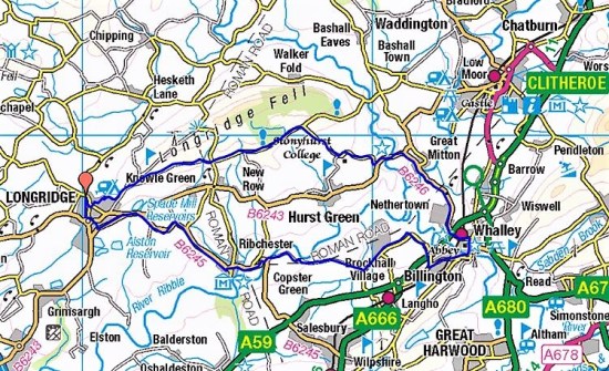
A walk I must have done dozens of times. I was looking for a short flattish walk to test out my knee. Walk 22 in the Cicerone guidebook fitted the bill, and I was anticipating the woods full of bluebells. It turned out to be a day of bright sunshine but with a violent wind out of the east.

The Shireburn Arms in Hurst Green was busy with the sunny weekend weather. I didn’t use their car park but found a spot in the village near the war memorial. Lambing Clough Lane took me down past the C17th Trough House (they have a fetish for weighing scales) to the new Dinckley bridge over the River Ribble. The river was running low with the exposed pebbly beaches accessible.

This stretch seemed to be popular with dog walkers today – but doesn’t everyone own a dog or two now. Entering Marles Wood the path threads between the trees often awkwardly over the exposed roots. The bluebells were only just starting, but there was a good display of  Wood Anemones and the Lesser Celandines were hanging on. The new beech leaves were the greenest of greens.

At Sales Wheel the river was completely placid, compare with conditions when running high – SALES WHEEL – THE RIBBLE POST-FLOOD.

One of the problems with this circuit is the kilometre of road walking from Salesbury Hall to Ribchester bridge. The road however was quiet and my attention was directed to the wayside plants. The blooms of the Blackthorn are fading to be replaced by the emerging Hawthorn. Yellow Dandelions and white Dead Nettles covered the verges. Soon I was crossing the elegant bridge which has seen some recent damage from vehicles.

Onwards past the farm and into the riverside woods where flood debris is always piled up, but thankfully someone has been collecting the plastics. Unfortunately the right of way leaves the river, what a shame – if only access could have been obtained all the way back to Dinckley Bridge. I have in the past persisted in trespassing alongside the river but remember it being difficult. On this day in 1932, hundreds of folk marched on the famous Kinder Scout protest, and we are approaching a time when we may need to resist the Tory’s crackdown on our access to land.

I’ve always found navigating the fields here a bit of a challenge and Mark’s  directions didn’t really help. The bluebells in the woods at Starling Brook compensated for my previous disappointment. Wild garlic was also showing well, I must pick some for a delicious meal with poached egg.

There are good views of Pendle and the Ribble Valley from these hills. With luck, I arrived at the bridge over Dean Brook, the stream I followed to find Raven Lumb Falls last April.

A steep climb led back to Lambing Clough Lane and into Hurst Green.

As an aside on the way home I spotted another of those evocative slate poems next to St. John’s Church.  Poignant thoughts.

Anyone wanting to follow this walk could shorten it by parking at Marles Wood and avoid the loop into Hurst Green.

*****

CATCH UP AROUND ALSTON.

                                                                             Yesterday.

Today is murky and damp, this morning I’m still in bed reading when the window cleaner appears on his ladder. He comes the first week of each month, and I have to pinch myself that we are into February already. I chat to him, standing in my dressing gown as he moves around the house. He reminds me that one or two of my windows probably need replacing, another job to put on the slow burner of my ‘things to do’.

I tend to go into slow motion in the winter months, particularly at the start of the New Year. Somewhere I have a SAD light, but significantly have not been bothered to use it. Past winters have been shortened by regular trips to sunnier climes, but that is a thing of the past for me in the present pandemic. Even my local walking is curtailed by the persistent plantar fasciitis. I have a list of friends to catchup with, many of them lying low. Parliamentary matters are not helping. Even my annual Big Garden Birdwatch didn’t go to plan. Oh well, it was good that yesterday I had phoned JD and arranged a walk with him to get out of the house and catch up with his news. The last time we were out together was in July last year!  There have been several times when his close family have been infected or isolating, touch wood I have steered clear of any forms of Covid.

A simple walk was planned around the Alston area, Preston not Cumbria. The little blue car was parked up on Alston Lane by 11am, it had been raining until then. Off we went along familiar lanes, through farms and down soggy fields, until we were walking alongside the River Ribble. No navigational decisions were needed, so we chatted away the rest of the morning, we share a broad church. A few mallards were spotted on the river, but otherwise any countryside life was keeping a low profile.

Opposite Balderstone Hall is an ancient ford crossing of the river, which JD has completed several times in summer conditions. Yesterday, he was upset that gates leading to the river bank on our side were obstructed and locked. The reason maybe the new development being undertaken here. A large “architecturally designed” property is slowly being completed, no doubt at significant cost. We wondered about the environmental impact of such a design on this rural riverside. Maybe it has already won an award. From there we made our way slowly back up the valley escarpment via rather convoluted field paths, I was trying to avoid the hard roads. In parts, we used the out of favour Ribble Way path and ended up on the wrong side of barbed wire several times. We almost had a Starling murmuration from these trees……but not quite.

JD always makes a good cup of coffee, so I was glad to drive back to his house for the rest of the afternoon. His wife, recovering from a hip operation, probably had walked farther than us on her daily exercise routine around the village.

I had not taken many photographs, due to the dull weather and too much conversation, so for a better impression of the scenery by all means look at a previous walk.

However, a couple of pictures, harbingers of Spring, probably will do more for me than that missing SAD light. Having posted this, it’s time for me to get out of the dressing gown and do something useful this afternoon. I believe in yesterday.

*****

ANOTHER DAY — ANOTHER TREE.

I had been told by Clare, of Slate Poems fame, of another decorated Xmas Tree on the fell. I was up here to find it. Parking was difficult on this fine Sunday afternoon, remember the chaotic parking situation in our earlier lockdowns. The good weather had brought lots of families out at the start of the Christmas Holidays.

Would you believe it?  As I walked through the gate onto the fell, I bumped into Clare herself exercising her beautiful Collie.

I normally take the more northerly track overlooking Chipping Vale, I call it the ‘panoramic balcony track’, but there is also a track following markers going straight up the fell leading to boggy terrain, best avoided. Incidently this track goes through the site of some Bronze Age hut circles and burial grounds, I have tried unsuccessfully to locate these on the ground in the past. 

This was the way to the decorated tree and the way I followed today. The stone cairn has had an addition of balanced stones, often seen on rocky beaches, I suspect they won’t survive a winter storm. Not far past the cairn is the tree. It was decorated with more environmentally friendly items; fir cones, wooden ornaments and nut strings for the birds. Satisfied with my ‘find’ I continued on through those forementioned bogs to regain the regular track, which does have its own boggy moments.

The other Xmas Tree with its tinsel and Angel topping was passed, and I reached the Trig point. There were good views, but nothing compared to yesterday’s cloud inversion. Circling through the forest, I was surprised at the number of trees that must have come down in our recent storms.

Once looking across the Ribble Valley, Pendle and Samlesbury there was a repeat of the cloud inversion * in a southerly direction.

* Cloud inversions take place when the temperature is warmer higher up – such as on a hill or mountain – than it is down at the bottom of a valley

The colder air at the lower level traps mist and fog creating the impression of mountain summits floating above the clouds.

*****

Map showing the two Xmas trees…

A QUICK TRIP AROUND THE GUILD WHEEL.

Storm Arwen had passed through, but there was frost on the ground as I set off for a ride around Preston’s Guild Wheel this sunny morning. I wasn’t expecting to stop very often, but I did capture a few pictures.

In Red Scar Woods above Brockholes Nature Reserve, there was still plenty of Autumn colour.

The River Ribble was lower than I had seen it recently, with plenty of muddy banks on show.

The bridge taking the new Western Distributor road over the Ribble Link Canal is progressing fast.

At last, the Whistlestop Café, next to the canal on the University’s sports grounds, was open again, the first time for months when I’ve been passing. So I had to give them some custom and enjoy a quick morning coffee. That was about it really, I was home for an early lunch just as it started snowing.

CIRCULAR CYCLE TO WHALLEY.

Another sunny-day journey with the over-the-hill cyclist.

As I swooped down into Ribchester, at the back of my mind was the thought that later in the day I would have to regain all the height, plus more. The morning was perfect with blue skies and sunshine, and more importantly to me in my new cycling guise – no wind. A pause to look at the River Ribble at Ribchester Bridge and then along the south side of the valley. The Marles Wood car park looked busy with families setting off for a riverside walk. I enjoyed the quiet lanes that eventually wound into Whalley on the banks of the Calder. I’ve always been intrigued by the row of cottages as you enter the village, today whilst I was taking photographs a couple of residents emerged and told me that they had been built as workers accommodation by a nearby hall. They had no explanation as to why there were two levels of access.

Dropping into Ribchester.

The Ribble, at Ribchester Bridge.

Old St. Leonards Church, Langho.

Whalley bound.

Terrace Row.

River Calder and that viaduct.

Whalley centre.

My favourite café in the village was closed, so I just carried on towards Mitton with its three inns, a hall and a medieval church which I’ve mentioned before.  A fisherman was casting in the Ribble with proud Pendle in the background.

Medieval church and Mitton Great Hall.

  Talking of fishing, the last time I passed this way  the Three Fishes was closed but in recent months it has had a makeover and reopened under Michelin-starred chef Nigel Haworth. He is hoping to make it the best pub restaurant in the area, judging from the prices, I won’t be visiting soon.

The road ahead gave a rather disheartening view of Longridge Fell, my next objective. But first I crossed Lower Hodder Bridge with Cromwell’s Bridge adjacent, you can’t pass it without another photograph. This was the lowest point of the ride and I now had to climb 600 ft back up onto the fell, steady was the word. Once up there, I had a switchback ride all the way back into Longridge and a hot bath to ease my aches.

Kemple End,  Longridge Fell.

Cromwell’s Bridge.

Longridge beyond the reservoir.

***

A couple of extras –

Whilst I was climbing up the fell earlier, I had passed the well-known Pinfold Cross. This is what I wrote last time – The Pinfold Cross is a memorial to a former servant at Stonyhurst College and fiddler, James Wells. It was erected in 1834 at Stockbridge after he died in a quarry accident. On the front is inscribed the legend, ‘WATCH, FOR YOU KNOW NOT THE DAY NOR HOUR.’ Above this is written, ‘OFT EVENINGS GLAD MAKE MORNINGS SAD’. On the left is ‘PRAY FOR THE SOUL OF JAMES WELLS’ and on the right, ‘DIED FEB. 12TH, 1834′.

This is one of a series of crosses associated with Stonyhurst College whose grounds I have mainly skirted today. I did pass one of their gates and had time to ponder the school’s sign. I suppose times have changed and most primary schools now have a pre-school section. It is said that it helps children integrate better and prepare them for the learning experience to come. Oh! And it also provides a baby sitting service for busy parents out at work. What stuck me most was the 3-year-old reference. I couldn’t get it out of my mind and I imagined all these little children being abandoned at the school each day, God forbid if they were boarders. I’m sure it is not as bad as that and the toddlers have a great time.

Lily Allen, whom you may not be acquainted with, wrote a song expressing her own child’s anxiety left at home whilst Mum sang around the world. We have to be careful how we nourish our young offspring. Needless to say, I was humming the tune for the rest of the ride. Here is a version of this touching song where she is accompanied by Jules Holland – I’m only three.

THE INNER CIRCLE, JEFFREY HILL.

Feeling rather despondent after struggling to cycle around Longridge Fell the other day. I had  been hoping soon to embark on a multiday cycle tour but now I was full of doubts, what would be my daily mileage. Realistically, I should be able to average 40 miles or more per day in hilly country, but I thought I was falling short of that. I’m getting older and I don’t have a scale to measure myself against, what I could do 30 or even 20 years ago doesn’t apply any more. I’m getting out of my depth.

I eventually stirred myself this morning as the weather brightened — time to test myself. From my house to the top of Jeffrey Hill is a mere 4 miles but is constantly uphill with 700ft of ascent. I aimed to cycle it without a break. Today’s route is in red compared to the circuitous blue of a few days ago.

I started slowly up through Longridge’s burgeoning housing estates. Summoning up some speed to pass the dog walkers, trying to not look out of breath. At the golf club the road was closed for drainage works but I squeezed through to remount and climb triumphantly to the summit of Jeffrey Hill just past the car park.  Views of Chipping Vale and the Bowland Hills in one direction, the Three Peaks in the centre and Pendle in the other direction were too hazy for photography. A swoop down to the New Drop, now sold and being converted into apartments, and a right hand turn to follow the undulating road back past Craig Y, Upper Dilworth Reservoir and into town.

Approaching Jeffrey Hill.

Down to the New Drop.

Upper Dilworth Reservoir and The Fylde.

This took me just over an hour and I felt quite pleased with myself, slow but steady. I wouldn’t win any race, but I had proved to myself that my legs and lungs still have it. I’m trying to convince myself that cycling is wonderful.  My next ride — that road going the full length of the fell to Birdy Brow and the Hodder. Watch this space, not that it will be very interesting.

CYCLING AROUND THE FELL.

Blue skies, sunshine and calm conditions, perfect for a local cycle ride. Longridge Fell is my regular walking ground, but today I was going to circumnavigate it on lanes from Longridge. You will notice my post is titled ‘around’ and not ‘up’, I had no intention of cycling the high road over the fell, there are enough undulations on the planned circuit.

There was a chill in the Autumn air but by the time I arrived in Chipping I was suitably warmed up. The road I took follows the north side of Longridge Fell before dropping to Higher Hodder bridge. A steep little hill up past a once popular inn had me puffing and to be honest I was always a little out of breath on any incline from then on, I’m having difficulty getting cycling fit. Walking is so much more relaxing.

Great Mitton and its Medieval Church are skirted, then the road winds up through the Ribble Valley to Hurst Green. I’d planned a break here as there are seats on the village green. A walker with his Spaniel had bagged the best one, but I ate my banana on an adjacent bench before going over for a chat about all things local, a pleasant diversion.

Back in the saddle, I was soon back into Longridge, feeling rather tired from this modest ride. I had covered 22 miles but had ascended 1600ft in the process, there are no flat roads in the Ribble Valley.

And that’s about it. I didn’t take many photos.

Chipping.

Couldn’t resist another picture of Cromwell’s Bridge over the Hodder.


Hurst Green interlude.

On arrival back home this gigantic corkscrew had arrived on the building site opposite me. Earlier in the year we, the local residents, stopped Barratts, in the guise of homely David Wilson Homes, from disruptive pile driving on this site which is probably unsuitable in the first place for building on due to the shifting sands. They are now having to drill down 30–40 ft to find solid ground, don’t buy a house on Inglewhite Meadow.

THE OTHER WAY ROUND.

Preston Guild Wheel.   October 12th.

I was already halfway around The Guild Wheel today when I saw this sign…  I wasn’t sure as to why it was alongside the works for the new Preston link road but it fitted my mood for today.  I usually cycle the Guild Wheel anticlockwise for dubious reasons, but today I had decided to reverse it and go clockwise, which is what the majority do.

  That led to a debate in my head as to how we choose the direction for a circular walk or in this case cycle ride. Clockwise is the obvious choice as the name suggests, but other factors come into consideration. If a route is chosen from a guide book then we will naturally follow its instructions for ease of navigation, expecting the author to have planned the optimum way.

  Planning one’s own route from a map there are choices to be made. Gradients differ depending on the direction, you may favour a slow gradual ascent to a steep short one or vice versa. But then the descent has to be taken into consideration, a climb involving  scrambling is usually safer in ascent. Do you tackle the climbing at the start of the day when you are fresh or be faced with it as you tire towards the end? If road walking is part of the route again is this better sooner or later.

  Weather plays a part. The wind direction should be taken into account to try and avoid walking into a gale on the high ground, have the wind at your back in those situations. If rain and cloud is forecast it is usually better to be lower down when it is at its worst. Unfortunately our variable weather patterns mean there is no certainty in making the right decision.

  It is possible that views, particularly in the mountains, are supposedly superior from one direction than the other, so this may influence your decision. Also, the position of the sun will influence you if photography is important.

  This is becoming complicated. No two people will agree on the best option and it is interesting when walking with friends how our choices differ. Compromise is usually needed or the toss of a coin!

  Linear walks come up with similar dilemmas. East to west or west to east. North to south or south to north. On long distance walks once you have made your choice if the weather changes bringing wind and rain into your face it’s a case of c’est la vie.

  Whatever your choice you always have the chance to repeat the route in the opposite direction giving a totally new perspective. Two for the price of one. Next time you are out on your favourite walk or ride do it the other way round.

  As I said that is what I was doing today.

  But not only that. I pass a sign every time I cycle round pointing to a Riverside Walk Via  Bullnose and today I intended to investigate.

I cycled along a shady path and then came out onto the embankment overlooking the River Ribble. This is in fact the outer wall of the basin leading to the docks, the ‘Bullnose’, separating the dock entrance from the Ribble. The glory days of the dock, once Europe’s largest inland dock, are long gone, they closed for commercial use in 1981 and now used as a marina and leisure facility. I was able to go right to the end of the Bullnose jutting out into the river for views out towards the estuary.


The Bullnose is obviously popular with anglers, judging from the number there today. They fish for eel and flounder, and this angler landed a small flounder whilst I was chatting to him.

Usually there is a bridge over the locks at the end of the promontory but today the lock gates were open so I had to backtrack around the outer basin to the main swing bridge at the dock entrance. I was then back on the guild wheel to complete my clockwise circuit with views back over to the Bullnose.

*****

ROUND AND ROUND AND UP AND DOWN I GO AGAIN.

   Another trip around the Preston Guild Wheel.

  Over the years I have posted several reports of cycling The Preston Guild Wheel. The last one was Dec. 2020. Now that I’m back in (enforced) cycling mode it was time for a revisit.

  As usual, I park at the Red Scar Industrial Estate and unload my bike thus avoiding the increasingly busy road through Grimsargh. Going anticlockwise, I seem to pass most cyclists coming the other way, all with a cheery hello. There is a new stretch of tarmacked cycleway leading to Durton Lane in amongst new developments, avoiding the traffic on Haighton Lane. From now on it is one new housing development after another, some have been completed since my last visit with others half finished with brave new owners living amongst the mess. Frighteningly, any other available space, green or not, is fenced off ready for the bulldozers. It is all very depressing.


  I enter the mature estates of Cottam  where the cycleway weaves between houses. As usual, I’m not paying attention and come up against a gate I don’t remember, of course I was lost and had to backtrack to pick up the route. Along here I almost had my first ‘road kill. — a squirrel ran as close to my front wheel as possible without being squashed.

The wrong gate.

   On through the University playing fields and out along the Ribble Link Canal. Here are more diversions where the M55 link road is being constructed, it doesn’t seem to have progressed much since my last visit.

  I notice men with big camera lenses alongside the dock railway and with a little luck as I cycle the Ribble Embankment along comes a steam train for some extra excitement.

  Preston’s Parks whizz by and I’m soon leaving the Ribble into Brockholes Nature Reserve, I didn’t stop to visit the ‘getting to know snakes’ encounter advertised for this afternoon. I’m always glad to get out of the saddle for a while for the push up the steep hill of Red Scar back to the crematorium and my car. But today on a whim I went round again, another 21 miles, albeit more slowly, there are more hills than you realise. I have a secret plan and I need to see if I’m getting cycling fit, the answer is not quite yet.

*****

  In my head were the lyrics “round and round and up and down I go again” which I couldn’t place. Once home Google soon unearthed Let’s Twist Again, a big hit for Chubby Checker in 1960.

  This is not to be confused with Twist and Shout which became a Beatles hit. They performed it at The Royal Variety Performance in 1963 when famously John Lennon said “For the people in the cheapest seats clap your hands and the rest of you just rattle your jewellery” much to the amusement of the Queen Mum. But I digress.

COFFEE ON THE FELL.

P1030909

Thursday, July 15th. 7.5 miles. Knowle Green/Longridge Fell.

10am. As usual, I’m festering in bed with a second coffee and the day is drifting away. The high temperatures ensure I’m not rushing off anywhere. The phone rings and I prepare myself for fending off Amazon Prime or Netflix scams. But no, it is JD enquiring if I’m wasting the day or would I like a walk, 5 or 6 miles up the fell? I say yes to the latter and hurriedly sort myself out to meet him at the top of town. Things have gone quiet since my trips away, I’ve been bouldering up in Sweden Quarry the last few days, where there is shade from the hot sun, but my arms need a rest, so a walk is perfect.

We take the path through Green Banks Quarry housing estate, given planning permission on the understanding that it would be for tourist lets and bring prosperity to Longridge, what a joke. A bridleway goes down to the Written Stone, all familiar territory. We catch up, he’s been away in the Lakes, and I’ve been straight lining it to the North Sea. Our vague plan was to walk field paths above Knowle Green and then maybe climb up onto Longridge Fell.

P1030892

Coincidentally, one of the last times I was here was with Sir Hugh on that straight line walk I mentioned earlier, back in winter 2019. https://bowlandclimber.com/2019/02/04/sd-38-longridge-to-barrow-whalley/ So I had a ready-made continuation walk on paths not known to JD or to many others, judging from their wildness. The same farmer who appeared from his run down house back in 2019 was eager to chat again today. He was all talk of shearing his sheep tomorrow and how if he penned them in on his cobbled area they would clean the yard of vegetation. There is no money in sheep wool these days. He warned us that the footpath ahead was difficult to follow, but I thought I knew better until we ended up in the wrong field. I did at least find the hidden way across Cowley Brook.

P1030896   Working our way up pathless fields to Hougher Hall was hot work, the dreaded Horse Flies were a menace. The slate poem by the gate is a lovely reference to swallows, unfortunately there aren’t many about this year.P1030902

   It was with some relief that we arrived at the open fell by the little reservoir. This where JD pulled out an ace and set his stove up to prepare a decent coffee with biscuits. Luxury. Friends of mine wild swim in this water, but I see that a ‘No Swimming’ notice has been erected since last I was here. Presumably, United Utilities Health and Safety.

P1030904

Barista extraordinaire.

   Refreshed we continued up onto the fell, looking back the reservoir appeared hazily below. P1030905    We had no need to visit the trig point, and it was now all downhill on the spine of aptly named Longridge Fell. There was some friendly discussion as to the length of our walk, JD’s 5 or 6 probably transformed to my 7 or 8 miles.

   Guess what, we finished the afternoon having  another coffee with his wife on their sunny patio with their wonderful Bowland Panorama.P1030910

   Simple pleasures but maybe too much caffeine.

*****

CaptureKnowle green

TEMPUS FUGIT.

   We used to be giants – so when did we stop?

I first looked into this large hole in the ground, hidden in the forest on Longridge Fell, many years ago and climbed a few routes as well as some boulder problems. I called it Sweden because of the fir trees. Time passes and one’s attention goes elsewhere, but I never forgot. With travel restricted, the popular bouldering venue Craig Y Longridge became even more crowded at times, so I stayed away. I remembered this place though, the trees have been felled and the plantation has become popular with dog walkers. I mentioned it in a post a while back. Well since then on sunny evenings I’ve been visiting this place, cuckoos are calling across the way, mallard ducks are paddling in the pool below and barn owls have successfully nested in the higher parts of the quarry. The Ribble Valley is a distant view away. Magic and memories.

Looking back through my photos from 25years ago, I have found pictures of the walls up here with dotted lines drawn to show the problems I had succeeded on. The clean wall I’m now revisiting used to have JOKER in large red letters painted right across it, that has faded completely. And now the joke is on me, as I’m finding all the problems far harder than I remember. Tempus fugit!

I used to climb here with Tony, Pete and dear old Dor. Everything was fun and everything was possible. They are all dead now, and I miss them so.

We used to be giants.

NOT AN OTTER ON THE HODDER.

JD phoned to suggest a walk by the rivers to try and spot otters which have been present recently. Suffice to say we didn’t see one but had an enjoyable walk nonetheless The stretch of waters we walked by I’ve described so many times in these pages, so I do not intend to repeat it here. We started on the Hodder and walked to its junction with The Ribble and then carried on to Hurst Green, basically part of the  Tolkien trail. Spring flowers were more varied with new species appearing, the bluebells continued to put on a good show and of course the wild garlic was at its best in the damp shady places. Many of you will know the route on seeing this tree, the Winkley Oak.

Midweek is becoming much quieter as many people have returned to work, we met only a handful of dog walkers. A favourite spot is where the Hodder and Ribble join, there is a bench inside a fisherman’s hut which provided a comfortable lunch spot looking out over the rivers. Farther downstream near Hacking Hall the sandy banks provide nesting spaces for Sand Martins which were flying low around us as we passed, lovely to see them back. A thunderstorm with heavy rain caught us on the last stretch to Hurst Green, the sky above Pendle having taken on mysterious dark hues. Pubs are still only able to serve outdoors and because of the rain there were no takers in the Shireburn or Bailey establishments  when we passed.

This was the first time I’d been walking with JD for probably 6 months, thus the lack of Otters didn’t dampen the day, but the rain certainly did try to.

SOUTH OF THE RIBBLE AGAIN – OSBALDESTON.

Friday, May 7th.   8.5 miles.    Osbaldeston.

I’m just about to eat my supper;  wild garlic encrusted fish,  a poached egg and new potatoes. The wild garlic was picked on today’s walk from one of the numerous wooded dells I traversed, my rucksack will smell of garlic for days.

 Two days ago I was in Balderstone and today I’m parked in Osbaldeston, a few houses in a row.  Obviously  ‘balderston’ is the common phrase. I’m off to explore another bit of countryside south of the Ribble bypassed by the busy A59.

The little lanes around here are fairly free of traffic mid-morning, but I suspect will be a different matter at school and work times. As I said Osbaldeston is hardly a village, a row of mixed cottages and affluent houses with large gates, you know the sort. I was soon in fields where one stile led to another making navigation simple. I’ve just realised that hedges and not walls mark the boundaries in this area. The elegant steeple of Balderstone church was always peeping over those hedges and up above Mellor Moor, but more of that later.

I spotted a deer running off up a field and when I passed this dell I heard crying – and there were two very young calves left in the grass. A quick photo and I left as soon as possible, what a start to the day.

The next group of houses, Studdlehurst, were hidden away at the end of a lane. Again large gates and horsey activities were evident. The man mowing the lawn of what was probably the original farmhouse was chatty, mainly about the weather, his massive garden and the state of the footpaths since lockdown.

The next house had distanced itself from the general population behind electric gates, but had provided excellent waymarks, gates and stiles on the public rights of way – what more can you ask?  Mercyfield Wood was full of bluebells, I apologise if I took too many ‘bluebell pictures’ today.

Crossing fields towards the river a new fence was going up but the original stile will be reinstated, the workers told me. At last, I was down by the River Ribble which was flowing quickly after overnight rain. I was on the lookout for Otters but to no avail. All the usual birds were present with Sand Martins making a return.  Across the way was Hothersall Hall and I had a different view of it than from my usual walks.

The RofW path cut across the land to Osbaldeston Hall however a concessionary path was signed by the river so I gratefully followed that. A large group of Swans were paddling about farther on below the Old Boathouse.  At Osbaldeston Hall I was pleasantly surprised to find the footpaths well-marked and the landowners going to a lot of effort to make life easy for the walker. I had only seen this hall from the Ribchester side before so it was good to come close up. A pleasant spot for a snack in the sunshine which had been in short supply until now. The old ‘Boathouse’ on the other side gives a clue as to a former ferry as well as a ford marked on an old map.

One cannot but sympathise with the farmer if his sheep are being worried, I fear that with the vast increase in dog ownership there will be a corresponding increase in irresponsible ownership.

The next mile or so was a switchback in and out of woods and ravines. Again plenty of scope for bluebell pictures and for picking some wild garlic for supper.

Once I approached C17th Oxendale Hall I was being watched by security cameras, the footpath became enclosed circling the property and I could have continued into the woods without seeing the Hall. An unmarked public footpath, not meant to be used, in fact crosses their frontage for a close up view. Of course, I was spotted and asked, or rather shouted at, if I was lost? I wasn’t lost, and I didn’t have the time of day for further conversation so continued on my way.

The next hall, Showley, another Grade II listed C17th but much altered, was something of a difference. The agricultural junk started well before the house and continued in most available directions. They deserve a listing for the amount of junk.  I wonder if they get on with their neighbours at Oxendale Hall.

I picked up a lane taking me back to the A59 and after some time was able to cross safely this busy road. Once on the other side I had a choice of low level field paths back to my start or climb up onto Mellor Moor, the weather had improved and I knew the view from up there was worthwhile. Hence, I started the slow trudge up the lane and onto the open moor. Stopping for breath gave me an excellent view of Pendle.

The top of the moor is marked by a trig point but more unusually by the site of a nuclear monitoring post. A plaque relates its history. The Lancashire Telegraph had this write-up.

Concrete blocks amid the swaying grass are the only outward signs of what used to be a large underground nuclear monitoring post for the Royal Observer Corps, which opened in 1959. It closed just nine years later and has since been sealed.

Three men would have entered the post during times of potential nuclear attack and reported on explosions read off special equipment installed to read blast pressure, power and flash. The bunker, therefore, had its own source of power, ventilation, communications, sanitation, food and water.

The monitoring post was just one of 1,500 across the country which would be able to track and report any nuclear fall out, keeping the local population informed of the level of danger. Thankfully they were only ever used for training and exercises.

In the Second World War, an above ground look-out post was built here, too, by the Royal Observer Corps, for spotting identifying and tracking hostile or friendly aircraft flying over this part of East Lancashire.

A direction indicator has also been installed for the far-reaching 360 degree views across the surrounding countryside, Wales, the Lakes and Yorkshire as well as all the nearby Lancashire hills.   Apparently this was also the site of a Roman signalling station, overlooking Ribchester from around AD 80. Earthworks are marked on the map but I’ve never identified them on the ground.

Pointing to Bowland.

I intended to follow footpaths back down the moor but came across this unfriendly gate. Not one to turn back on a public footpath I entered the grounds leaving the gate ajar in case of a hasty retreat. No hounds appeared so I was able to progress to the next obstructed stile. Why do people buy properties knowing there are rights of way through them only to do their best to keep the public out? Another one for reporting to the local authority.

 More friendly fields took me down and across the A59 again to bring me back into Osbaldeston. Today I was luckier and my friends in Mellor Brook were home so a pleasant glass of wine was enjoyed in their garden before coming home to cook my supper.

*****

THE OTHER SIDE OF THE RIBBLE – BALDERSTONE AND SAMLESBURY.

Wednesday, May 5th    11miles.    Samlesbury.

Where haven’t I been for a while? Well it’s several years since I explored the countryside visible southwards across the River Ribble. In the past I thought that the footpaths were difficult to follow and rights of way ignored on the ground. Time for a revisit. So I found myself parked up in Balderstone;  a school, a church and a couple of houses. I waved to a man delivering hay to one of the houses and then I was off along quiet country lanes. At Lane Ends I visited a trig point, for no obvious reason, at the lofty height of 74 m.

My first objective was to visit Balderstone Hall on the River Ribble and view from this side the former ford across to Alston. I’ve recently been looking at this scene from the Alston side.

https://bowlandclimber.com/2018/11/08/alston-looping-the-loop/

https://bowlandclimber.com/2021/01/08/river-ribble-at-alston/

A pleasant stroll down fields above the river brought me out into the confines of expensive and secluded properties. A right of way was shown on the map but it looked daunting. As it happened a couple of builders whom I knew were working on a wall of the Hall, they said nobody was about and showed me the way through past the rather intimidating signs. I didn’t like the look of the river crossing, maybe in high summer and low water I’d be tempted. The old map marks the ford.

 I retraced my steps and left the exclusive properties for a path past a more run down farm. Crossing fields on the flood plain I bypassed a large farm and climbed back up the escarpment to reach a road heading west to Bezza House. Years ago, when Bezza was a tree nursery, I used to come here with Dor and many of the trees in her and my garden originated from here. One in particular that she bought was the ‘handkerchief tree’ Davidia involucrata, an exotic specimen from China. It takes years to flower and so one spring whilst they were away for the day I went around with a ladder and white paper tissues which resembled the flowers from a distance. Suffice is to say that they were well and truly tricked but the tree had the last laugh by flowering the next year and every year since.                                                                                                               

There are great views from up here of the Thirlmere Aqueduct crossing the River Ribble.

Where the road used to continue bollards have appeared and now only a bridleway continues to Samlesbury. And what a pleasant bridleway it was;  lined with spring flowers, bordering fields full of lambs and having views across the Ribble to Alston, Longridge and beyond.

It was getting near lunchtime so I hurried to reach St. Leonard the Less Church where I expected there to be seats. I was not disappointed, in fact a couple of walkers were already occupying the prime bench. The church unfortunately was closed. It has some very old box pews, apparently. I had to be content with the exterior views of the oldest, C16th, sandstone part and the distinctive tower built at the end of the C19th. In the graveyard was an ancient sundial, 1742,  and a large font, 1769. The adjacent primary school is also of a certain vintage, I’m always cautious taking photos near schools.

A path climbed fields towards a house which turned out to be another religious establishment, the Roman Catholic Church of Saint John Southworth  and presbytery.

An old sunken track high above the busy A59 was a hidden delight to walk. Peace came to an abrupt end when a stile deposited me onto the pavement adjacent to the traffic lights at the busy junction next to the Five Barred Gate motel.  

Once across safely I was happy to follow  the quiet lane past the extensive sewage works. Up and down it went until I was able to take a footpath across to another lane, thus by-passing the Nabs Head  pub which has too many recent memories for me. I was soon on the pavement outside the C15th Samlesbury Hall. What a magnificent building this is and to think it was bought in 1920 for demolition, only to be saved by a local trust. I crept into the grounds for a closed look.

Crossing the busy road I made use of a quiet bridleway, Park Lane, taking me to Mellor Brook. I wished I’d had a bag to collect some wild garlic. From up here I could look across the extensive BAE site and the Ribble Valley to Longridge and the Bowland Hills. 

I took a footpath behind houses where friends live hoping for a cuppa, but they were not at home. This humble little stream, Mellor Brook, once fed a mill pond that supplied water to a cotton mill.

The village deserves a better look with little alleyways and old houses. An unknown lane went under the A59 and out into the countryside. Fields headed back to Balderstone with the church spire always prominent. On the way I passed the grand looking Grange, you could rent its nine bedrooms on Airbnb for £2000 per night. 

Arriving back at the school I was greeted by the man who’d seen me set off this morning. Turned out he was the school caretaker and seemed impressed by my modest mileage. I had time for a look around the outside of St. Leonards Church. It dates from the C16th but was rebuilt in the 1850s, the tower and prominent steeple were added in 1905 by those old favourites of Lancashire church architecture Austin and Paley.

I have had perfect weather for today’s enjoyable amble in this delightful backwater just off the A59. It was worth crossing the Ribble.  Looking at the map I will return and complete another circuit to the east based on Osbaldeston.

SEARCHING FOR RAVEN LUMB FALLS.

I’m fascinated by the history of the countryside. I glean as much as I can from books, maps and the internet. The origin of names: lost houses and tracks: the local industries from way back: family trees and intrigue. So when I come across a reliable source of information to one of my regular walking areas I’m delighted. The area in question is Hurst Green and Stonyhurst and somebody has set up a Facebook page dealing with precisely that.  https://www.facebook.com/hurstgreenandstonyhursthistory

I was alerted to it by a comment from its author on my Stonyhurst crosses walk for which I found it difficult to obtain information. I have some catching up to do with the posts so far, but I did notice one on a waterfall on Dean Brook below Hurst Green – Raven Lumb Falls. Over the years I have scrambled up a few of the brooks coming down from Longridge Fell to the Ribchester and Hurst Green areas, but I was unaware of this location. It didn’t take me long to identify its approximate position on the OS map and this morning I set off to explore.

Hurst Green was busy with walkers, most probably following the Tolkien Trail which I did a few weeks ago. Today I set off down Lambing Clough Lane, there were certainly plenty of lambs about. At the ‘farm’ I took a public footpath, strangely unsigned, down towards Dean Brook where it is joined by Bailey Brook at a footbridge. There is an open green area here,  locally referred to as Pickleholme. I now followed the stream up into Merrick’s Wood.

Celandines and Wood Anemones were still in flower, but as a bonus the Bluebells were just coming into bloom in blue patches under the trees.

There was more water in the brook than I had expected after all this dry weather, I would have been better in wellingtons to walk directly upstream, as it was, I used precarious little tracks with an ever present risk of tumbling down the steep bank into the water.

Anyhow, I made progress until at a bend the fall came into view. The water had carved out a passage through the sandstone cliff. Care was needed boulder hopping here as I don’t think anyone would have found me if I’d had an accident. The grid reference, for anyone foolish enough to follow in my footsteps, SD 6830 3746.

What a delightful spot deep in the woods with a lively flow of water. There was some tat left by gill scramblers from Hothersall Hall. The rope was in bad condition so I removed what I could reach. I need to return when the water level is even lower to try and scramble up the falls.

I sat for half an hour and watched  a Dipper coming backwards and forwards, with grubs in its mouth, to a nest hidden in the rock. A pair of Grey Wagtails, or Yellow?  were flitting about in the stream.

What a pleasant way to spend a morning.

When I arrived back at the Shireburn Alms the beer garden, sorry dining terrace, was full of diners enjoying the sunshine and their freedom to eat out. A far cry from down below.

ANOTHER DINKLEY ROUND.


A peaceful Sales Wheel.


Wednesday, April 14th.    6 miles.    Ribchester,

A perfect Spring morning, sunshine and no wind.

Looking back I did this walk in 2019 on a similar April day https://bowlandclimber.com/2019/04/11/more-of-the-ribble-way-and-dinkley-bridge/ and on many other occasions.

We set off from the car park of the Ribchester Arms, which later today will be serving food and drink outside following the latest easing of lockdown. Some, new to us, paths lead away across fields from Stydd Lane. The signing was better than usual, a side effect of the pandemic with the farmers trying to guide all the extra walkers through their fields as safely as possible. We were intrigued by some old banking alongside Duddell Brook which seemed to have been designed to prevent flooding of some fields that would have been a natural flood plain. One wonders if this channelling of the stream goes towards the flooding that regularly occurs farther down where it meets the Ribble. Never mess with nature. I’m not sure whether the banking shows up on my photo.

An innocuous looking Duddell Brook.

The Ribble Way was joined and followed pleasantly along the river bank. There is always flood debris on this stretch but today it was mostly vegetation and wood, perhaps someone has a had done a litter pick of all the usual plastic. It is a shame that the footpath gets diverted away from the river [fishermen only!] but at least from the higher elevation there is always a  panoramic view of the Ribble Valley with Pendle on guard and of course now the new Dinckley Bridge.

Mike had not visited since the new bridge was erected in 2019, hence today’s route. The previous suspension bridge was damaged beyond repair back in the floods of December 2015, Storm Frank. Its centre span was previously destroyed by flooding in 1981, but cables and parts were salvaged and the deck rebuilt.  Prior to the bridges a ferry used to cross here linking Hurst Green to Dinckley and Langho.

Old suspension bridge. Wikimedia.

Today the river was very low under the bridge and the sandy beaches farther downstream were accessible. We were surprised there were not more people out and about enjoying the warm sunshine. In the woods the wild garlic was coming into season reminding me that I must pick some for cooking – perfect with a poached egg. The celandines, wood anemones and sorrels were all putting on a good show.

Again the path is diverted away from the river, so we just walked pleasantly along the quiet lane to cross the stately Ribchester Bridge back into the village and home for lunch.

*****

THE TOLKIEN TRAIL AGAIN.

Saturday  27th March.     6.75 miles.      Hurst Green.

I expected Hurst Green to be full of cars this morning, but we were able to park up outside the Bailey Arms with no trouble. I think we stole a march on most people by being away early. A new signpost has been erected near the Shireburn Inn to get you on the right track. Dropping to join the River Ribble seemed muddier than normal, a lot of people have come this way in the last few months. To start with we had the riverside path to ourselves with wide-ranging views. Only as we approached Winkley Farm did a steady stream of people start appearing from the opposite direction. Fishermen were wading in the Ribble just upstream from where it joins the Hodder. A new path, not particularly aesthetic, gives a dry way across a particularly muddy field. A lot of people were milling about at Cromwell’s Bridge and on the path alongside the Hodder, we couldn’t work out how some of these groups were constituted with no social distancing in evidence – I suspect people are coming out of lockdown of their own volition. Up at Hodder Court Gandalf is staring out over the Ribble Valley, although his hat seems ready to fall off. We walked on through the grounds of Stonyhurst College to a now busy Hurst Green. I dread to think what this walk will be like after April 12th when people can travel further.

Here are a few photos…

A deserted Bailey Arms, I wonder whether it will survive.

We were glad of our poles in the mud.

Aqueduct over the Ribble taking water to Blackburn.

Distant Pendle.

Hodder and Ribble meet – spot the fisherman.

That Winkley Oak.

The new ‘bypass’

Trail walkers with Stonyhurst in the background.

Cromwell’s Bridge.

A wooden Gandalf.

*****

For more comprehensive views of this walk please have a look at

THE TOLKIEN TRAIL.

TO CATCH A SALMON.

BROCKHOLES NATURE RESERVE – MY WAY.

Friday.  26th February.   4 miles.    Brockholes.

As I lay in the mud at the bottom of the bank, mopping the blood dripping down my forehead and checking my limbs for breakages, my thoughts drifted to casualty departments in the middle of the Covid crisis. Earlier in the day I’d been chatting to friends who were telling me that senior staff at Preston Hospital have stopped cycling whilst casualty is under pressure, they don’t want any broken bones. For the last week I’ve been looking up at Fairsnape Fell wondering about an ascent and then imagining a helicopter rescue and all the recriminations, so I’ve kept to the lanes for relative safety. Yet here I was lucky to get away with grazing and a blow to my ego. The brambles that had ensnared me were still wrapped around my legs. Being covered from head to foot in mud I drew surprised glances as I shuffled back to my car.

The rest of the gentle stroll in the sunshine had gone well. Brockholes is a nature reserve based on flooded gravel pits easily seen from the M6 coming south at J31. The Preston Guild Wheel cycling route goes through the middle of it so I’ve visited it many times but not in any depth. The only time I’ve called at the café/visitor centre was many years ago with Mel on one of his visits up north. My plan for today was to walk around the boundary of the reserve.

I had parked up near the crematorium in Grimsargh after one of those guilt laden 4 mile drives ‘staying local’.  The guild wheel route soon brought me down that steep bank into the reserve, here I turned left to reach the River Ribble thus avoiding the busy central areas. A good track followed the river all the way to the motorway bridge. Apart from the friends I unexpectedly met there were a couple of fishermen and only the occasional birdwatcher – you can tell them by the size of their telescopes. I wonder if there is some unwritten competition for the largest. I saw two Egrets by the river.

At the motorway I transferred to the gravel track bordering the west side of the lakes and was surprised as to how quickly I became almost immune to the traffic noise. There was one hide along here from where I saw ducks, grebes and swans – must get one of those big scopes, my equipment isn’t big enough. It was shortly afterwards I dived into the mud.

Just before going back up the steep hill I took a few minutes sat on a log, partly to clean my wounds and partly to watch the wild life feeding on crumbs left by a previous passer-by. Tits, a nuthatch and grey squirrels were my final tally for the day.

Think I’ll stay in the garden tomorrow.

Red Scar Woods high above the Ribble.

*****


BETWIXT AND BETWEEN,

Tuesday,  February 9th.     6.5 miles.    Longridge.

There is a bridleway running between Alston Lane and Hothersall Lane south of Longridge. I have not used it for years. The importance of this bridleway, at least for me today, is that it passes by the house of a good friend. I have heard through the grapevine, as you do in these parts, that my good friend’s wife has fairly rapid onset “dementia”. Rather than phone him I thought it a good idea to call by, ‘in passing’. Well despite giving me a good walk it didn’t work – he was not at home. So I am back at home and ready to phone him with the thoughts of the onslaught of dementia fresh in my mind. I would have much rather have seen him in person on the bridleway.


On a lighter note as I walked back up Hothersall Lane I came across a heavily laden lorry parked up. The driver jumped out to ask me the whereabouts of Hothersall Farm. According to his satnav it was in an adjacent field.  I was able to give him the correct information so my day was not entirely lost.

       *****

A BRISK WALK.

Sunday 24th  January.    8 miles.    Knowle Green.

  A hard frost greeted me this morning with little hope of the temperature rising above zero throughout the day.  I decided on a brisk walk around the lanes circling Knowle Green. Up to the New Drop, turn right down to the Knowle Green road, along Greenmoor Lane, back up Preston Road and Tan Yard. It was a grey day with the hills holding on to some of yesterday’s snow. The highlight early on being catching the Highland Cow and her youngster in a better photographic pose. I tried to capture a kestrel in hovering mode. After that I just marched around the circuit to keep warm.

*****