Category Archives: Lancashire.

BROCKHOLES NATURE RESERVE – MY WAY.

Friday.  26th February.   4 miles.    Brockholes.

As I lay in the mud at the bottom of the bank, mopping the blood dripping down my forehead and checking my limbs for breakages, my thoughts drifted to casualty departments in the middle of the Covid crisis. Earlier in the day I’d been chatting to friends who were telling me that senior staff at Preston Hospital have stopped cycling whilst casualty is under pressure, they don’t want any broken bones. For the last week I’ve been looking up at Fairsnape Fell wondering about an ascent and then imagining a helicopter rescue and all the recriminations, so I’ve kept to the lanes for relative safety. Yet here I was lucky to get away with grazing and a blow to my ego. The brambles that had ensnared me were still wrapped around my legs. Being covered from head to foot in mud I drew surprised glances as I shuffled back to my car.

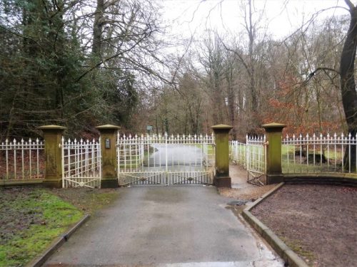
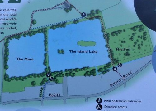
The rest of the gentle stroll in the sunshine had gone well. Brockholes is a nature reserve based on flooded gravel pits easily seen from the M6 coming south at J31. The Preston Guild Wheel cycling route goes through the middle of it so I’ve visited it many times but not in any depth. The only time I’ve called at the café/visitor centre was many years ago with Mel on one of his visits up north. My plan for today was to walk around the boundary of the reserve.

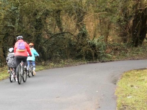
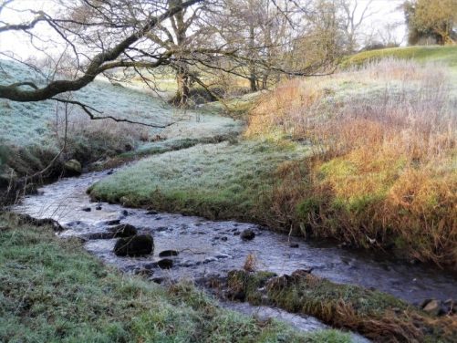
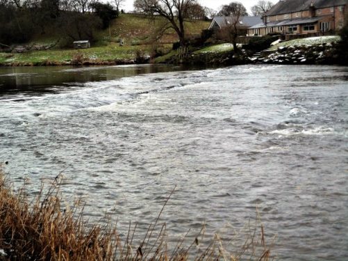
I had parked up near the crematorium in Grimsargh after one of those guilt laden 4 mile drives ‘staying local’.  The guild wheel route soon brought me down that steep bank into the reserve, here I turned left to reach the River Ribble thus avoiding the busy central areas. A good track followed the river all the way to the motorway bridge. Apart from the friends I unexpectedly met there were a couple of fishermen and only the occasional birdwatcher – you can tell them by the size of their telescopes. I wonder if there is some unwritten competition for the largest. I saw two Egrets by the river.

At the motorway I transferred to the gravel track bordering the west side of the lakes and was surprised as to how quickly I became almost immune to the traffic noise. There was one hide along here from where I saw ducks, grebes and swans – must get one of those big scopes, my equipment isn’t big enough. It was shortly afterwards I dived into the mud.

Just before going back up the steep hill I took a few minutes sat on a log, partly to clean my wounds and partly to watch the wild life feeding on crumbs left by a previous passer-by. Tits, a nuthatch and grey squirrels were my final tally for the day.

Think I’ll stay in the garden tomorrow.

Red Scar Woods high above the Ribble.

*****


ALL I NEED IS A DOG…

Monday. February 22nd.            Cowley Brook Woodland.

In a post last week I mentioned I’d wandered into Cowley Brook plantation coming off Longridge Fell. I didn’t mention that I had met a friend walking her dog there. She comes regularly to exercise the dog in an enclosed space with no sheep. Apparently others do the same, hence the reason I’d often seen cars parked here. Today I came back, on her recommendation, to explore the area in more detail, that’s the sort of thing I do in lockdown. The land owned by United Utilities has recently had trees cut down and new ones planted. They have opened it up for recreation without any path improvements, just some simple environmental advice.

I choose a newly trodden path through the mature trees alongside the little brook, it took me down the hill and into a more open area.  Most of the newly planted are deciduous but firs are cropping up from seeds in the ground, It was good to see a kestrel hovering overhead.  Keeping  going alongside the water until a gate into a small water catchment area which led to the Old Clitheroe Road. The stream disappears under the road here. I have passed this way many times wondering about access up the stream, deer are a common sight in this valley.  Signs suggested they didn’t want people in the works’ area, maybe I had gone too far.

Pleased with myself for finding this link up I retraced my steps back into the new plantation heading for the top edge where I entered the mature dark forest and made my own path back up the fell. At one point I jumped out of my skin as a hound, Baskerville size, came hurtling through the trees with no sign of an owner. There had been more cars parked when I arrived, so I presume it was from one of those – never to be seen again.

I progressed up the hill towards a fenced off quarry in the felled area. I profess to having prior knowledge here. Years ago when this hole in the ground was surrounded by trees  I would climb the stone wall into these woods and disappear into the hidden quarry for some esoteric bouldering on its dark damp walls. The other day I came across some photos and a guide I had written – it slowly reverted to nature but gave me entertainment and exercise for a couple of years before I moved on elsewhere. Simple joys that have been derived from the outdoors throughout my life. And here I am again peering into its depths.

Picking my way through the new plantation I head back to my car just as my friend appears exercising her dog. She must come most days. We reminisce about past times and friends. Years ago I sold my house to her parents; I hadn’t found another one at the time, so I stayed on in a flat above the garage, the arrangement suited both parties, rumours of ‘ménage à trois’ circulated in the village. The lady I’m talking to today would have been 4 or 5yrs at the time but remembers it well. She is now a talented artist and does a lot of good work with schools, community groups and underprivileged youths. I’ll give her a plug with a photo of her van.


That hole in the ground.

Distant Pendle.

***

I have not shown my erratic wanderings on the map below, just an outline of the woodland. It will be interesting to see how this woodland haven develops.

I have been back this evening for further exploring.

ROUND LONGRIDGE WALKS.

Monday. 15th February.     6.5 miles.     Longridge.

Somewhere I have a small tatty leaflet from many years ago detailing a walk around the outskirts of Longridge with a sketch map showing the route. I might yet find it.

***

Anyhow, I felt I knew the way so after lunch today I ventured out to join the circuit. The walk keeps to the rural edge of the village for most of the way but now is becoming encroached upon by the new housing developments.

(for an alternative updated versions with maps see the end of this post)

But below in the meantime is a more than detailed description of the original route with photos of the obvious sections.

***

A good place to join the circuit is on Higher Road near John Smith’s Playing Field and the old Quarryman’s Arms pub where there is parking. Round the corner you go down a cutting, Tan Yard, into old quarry workings. There are some stone houses here, one looks as though it could have been the quarry master’s house, there are good views over the reservoirs to West Lancashire.

On down Tan Yard lane to reach the busy Lower Road.

Almost opposite is a farm lane with elaborate gate posts. It leads to a cheese and meat packing plant. A stile leads ahead, and then you bear right to another stile giving access to a green lane going south. At its end cross the field diagonally towards the far right corner.

Finding a footbridge down on the right and up to the sturdiest stile in the Ribble Valley. A field to Alston Grange Farm.

At the farmyard go round to the left of all the buildings and then rightwards to a stone stile on the Alston Grange farm access lane. Go left here.

At the next lane you turn left onto a path past a collection of eco lodges. At its end go over a stile turn right and follow fields north of the reservoir.

At the end of the field a lane goes left around the reservoirs and then right onto the tarmacked Pinfold Lane. Along here are some bird watching hides on the redundant Alston 3 reservoir.

At the end of the lane [notice the old stone cross base in the field on the left at the corner] you join the busy Preston Road and cross over to follow the pavement  past the Franco’s Italian Restaurant and Forshaw’s Yoghurt Dairy until opposite the White Bull Inn a concreted track, the left one, goes towards Daniel’s Farm.

Once through the farmyard a rough track goes across fields over a stile and footbridge to follow the hedge until a metal gate on the right gives access to the football pitches. Go straight across to the car park and then go left through the gates, across the old railway and Shay Lane.

Directly opposite a path goes alongside sawmills to cross a small stream and then turn right up Green Nook Lane.

This comes out onto Whittingham Road near new housing. Follow it left until a turn into Halfpenny Lane. Halfway along you pass the historic Old Rib Farmhouse on the left and a little further take a footpath diagonally left to join Inglewhite Road where you walk up the pavement out of Longridge.

From Inglewhite Road you branch off into Clay Lane. This has been a droving route into Longridge in the past and there was once a clay brickworks along it.

You emerge onto the Chipping road at a bend and walk on until you can take Mile Lane leading up towards the tail of Longridge Fell. I have come this way many times.

At the top bear right and go through trees on a narrow path, which had been a rail line to a small quarry, and then head left up through the park to pass a children’s’ play area and the old tunnel, now blocked, taking a branch rail track into the major Tootle Heights Quarry, You emerge from the park and go left to Higher Road and your starting point.

*****

After a lot of searching I’ve found the piece of paper with a map of the route. It is marked as page 12, but I’ve no idea where it originated from. Perhaps some of my Longridge readers may have a similar copy.  I suspect its vintage is 40 years ago.    I notice that I didn’t quite follow the suggested route at Pinfold Lane, so I returned to walk the leaflet way past Bury’s Farm. It is poor with broken stiles, indistinct paths and a horror of a farmyard at Bolton Fold, so I think my Pinfold Lane is better despite a little further by the road. I have shown both routes on my map below.

Some years ago a Longridge Partnership Action Group alongside Ribble Valley Borough Council produced an attractively illustrated pack detailing 6 walks in the area, One of these is the same route as the one I walked above.

Another leaflet you may come across details Heritage Walks within the town itself.

These may still be available.  The Railway Café Heritage Centre is a good place for information, in more normal times.

***

As I mentioned I have subsequently devised a more rural around Longridge route avoiding roads and Housing Developments wherever possible.  Look here.

For a slightly shorter version, 7.7m as opposed to 9.5m, and easier to navigate, I would recommend the one below. 

BLUE SKY DAYS.

Wednesday  10th January.   6.5 miles.    Bleasdale.

Thursday  11th January.  8.5 miles.     Longridge Fell.

Friday  12th January.  7 miles.  Beacon Fell.

You just had to be out these last three days, perfect dry and sunny conditions. I managed three walks and enjoyed blue skies each day on the lanes around Longridge. Below is a snapshot of each day.

For the trip around Bleasdale I met up with Mike and despite the forecast of below zero temperatures there was no wind so it felt almost like a spring day. We extended the walk from Bleasdale Tower to Delph Lane as we were enjoying the conditions so much. I’m glad we did as it gave a sighting of a barn owl flying low in front of us.  The coast looked very near in the clear conditions.


***

The next day I had just intended to follow the road loop up onto Longridge Fell, but I couldn’t resist the continuation up to the trig point and into the forest, the usually boggy terrain was frozen solid. The Bowland Hills are virtually clear of snow whereas Pendle looks plastered. On the return I wandered into plantations at Cowley Brook, I had seen cars parked here previously, and I found new leisure tracks opened up by the water board, I will have to visit again for a full exploration.

***

Today I drove a short distance out of town and walked the quiet lanes up to Beacon Fell, there were a few people about near the summit but I virtually had the place to myself. All was still and peaceful. I wonder if we will get any more snow this winter?

***


BETWIXT AND BETWEEN,

Tuesday,  February 9th.     6.5 miles.    Longridge.

There is a bridleway running between Alston Lane and Hothersall Lane south of Longridge. I have not used it for years. The importance of this bridleway, at least for me today, is that it passes by the house of a good friend. I have heard through the grapevine, as you do in these parts, that my good friend’s wife has fairly rapid onset “dementia”. Rather than phone him I thought it a good idea to call by, ‘in passing’. Well despite giving me a good walk it didn’t work – he was not at home. So I am back at home and ready to phone him with the thoughts of the onslaught of dementia fresh in my mind. I would have much rather have seen him in person on the bridleway.


On a lighter note as I walked back up Hothersall Lane I came across a heavily laden lorry parked up. The driver jumped out to ask me the whereabouts of Hothersall Farm. According to his satnav it was in an adjacent field.  I was able to give him the correct information so my day was not entirely lost.

       *****

THAT OLD FAVOURITE.

Sunday 7th February.   5.5 miles.   Longridge Fell.

I hadn’t intended to visit the summit trig point, I was in trainers for a gentle stroll around forestry tracks so once I’d left those tracks I ended up with wet feet. I expected more people on top judging from the cars parked up alongside Longridge Fell but found myself alone looking at the cold view across to the Bowland Hills. We have been lucky and avoided the snows in the last few days, although Pendle had a covering.

I had walked along the road from the Crowshaw parking to Kemple End and then up the zigzags of the forest trail. This is the first time I’ve been up here this year and I’d forgotten about the parking problems of lockdown. Mostly I passed dog walkers but also larger groups of ‘youths’ whom I doubt were from the same household or even this locality, they seem oblivious to the lockdown recommendations. Maybe rules would be more appropriate, but I doubt it would make any difference to these people.

Covid parking.

Covid walking.

A new section of forest was being felled alongside a path I often take.

On a more positive note I had an extended chat with a couple and two children from Grimsargh, he was picking up litter and setting a good example to his young family and any walkers who passed. The stretch up from the parking is the worst for cans and wrappers, he draws the line at poo bags. Why don’t I come equipped to do the same on my local walks – food for thought? One shouldn’t always leave it to that other person.

The litter picker extraordinaire.

It was sub-zero temperature as I wound my way back to the car. I had driven 3.5 miles to reach my 5.5 miles walk, that is a bit dubious in my book but at least I had climbed a fell, if only a modest one at 350 m.

Sorry but I couldn’t resist another lone glove photo…

*****


ALMOST A NOTHING WALK.

Thursday 4th February.  5 Miles.  Longridge.

Halfway up the steep Birk’s Brow lane I stopped for a breath; there was little to see in the murk, my mind had switched off a mile back, I was not even sure why I was there. Had I come to my Covid lockdown impasse? Had the repetition and boredom caught up with me? Was there a way out from this pandemic? I was taken aback by this negativity that had suddenly descended upon me. Was my hope fading? I had imagined I’d been coping well with all the setbacks and heartaches of the last year but was this the reckoning I had to face? Too many questions for which I couldn’t find an answer. I moved on in a cloud of my own making.

Birk’s Brow.

I have mentioned in several posts the poems written on old slates that have appeared around Longridge during these  troubled times. Uplifting themes and thoughts for us all to share. I often wondered who was the artist of these calligraphic verses. Well around the corner a lady pulled up in her car and proceeded to pick up the cracked slate there.  “Do you know ?… are you the person ?…”   I’d stumbled on the originator of all these slate poems. She had started with one and then been encouraged to do more with friends recommending poems. I was overjoyed to speak to the lady.

My day was saved, and I walked on through Longridge with a spring in my step.

*****

HAIGHTON.

Friday 29th January.     7.5 miles.           Preston.

I drive a couple of miles to Grimsargh and park close to my last walk to save repeating the same roads. Walking through Cow Hill and down to the cattery, then along by Savick Brook to the private drive of Haighton House is a walk I’m very familiar with. I climb up the bridleway to Ladyewell House and follow Fernyhalgh Lane past St.Mary’s Church and school to Haighton Top.

https://en.wikipedia.org/wiki/St_Mary%27s_Church,_Fernyhalgh

I was starting to think this was a mistake as It brought back too many memories of bringing my friend with Alzheimer’s  this way to keep her as active as possible. She loved this area and always brightened up on recognising familiar places.

A soggy Cow Hill.

Savick Brook.

Haighton House hidden in the trees.

Memory lane.

Today’s hill – bridleway to Ladyewell.

Ornate grave at St. Mary’s Church.

Simpler memorial.

The old Fernyhalgh School. My children started their education here, it is now a nursery.

I moved on across the motorway and was soon using the route of Preston Guild Wheel as it passes through the industrial estate behind the warehouses. I’m normally on my bike along here, so I had a different perspective today. A lot of the people using it are walking between areas of Preston as part of their daily routine rather than rushing round the whole circuit. 

The lone glove phenomenon.

Coming off the Wheel at the service station next to motorway Junction 31A I was surprised to walk past a farm in the close vicinity. My efforts to come out by a housing estate were thwarted by a deep flood across the path. So I continued along the old railway line, Preston to Longridge, even though it wasn’t a public footpath. It became more and more overgrown and, I only managed to escape by crawling under barbed wire fences at Grimsargh Church.

Little Rough Hay Farm.

The back of Spar’s distribution centre.

No way.

The old railway line.

No problem…

…disappearing.

Escape.

From the bridge I rejoined the railway, now a made up track through Grimsargh to where the station had been. What a shame the ‘powers that be’ couldn’t connect it to the stretch from the motorway.

‘Grimsargh station’

Originally a farm, then a coaching inn. It served rail tickets before the station was completed.

Another successful local walk, although not quite from my front door.

*****

Watch out for the wolf moon.

*****

MELLOW MISTS.

Wednesday27th January.     7.25 miles.    Grimsargh.

The frost and snow have gone, for now. Today is misty and murky, I can’t even see the fell from my house. I had a low level walk planned along the roads back to Grimsargh for another look at the wetlands, today would be ideal. On the way I dropped off an apple crumble for my friend in Brabiner Lane, he wasn’t in so will find it hopefully on his doorstep later. Brabiner Lane is renowned for its twisty narrowness and is best avoided in a car. With little traffic at present I crept carefully around its bends. I passed the embankment where there had been a bridge for the branch railway line to the old Whittingham Hospital mentioned in the above post. It was depressing to see so much litter along the verges. More new housing was going ahead at the entrance to Grimsargh Green.


Welcome to Grimsargh.

I chatted to a friend on the Green about our Covid vaccinations – the hot topic at the moment, She has managed to get two, I have mine on Sunday hopefully.

When I explored the ‘wetlands’, redundant reservoirs, a couple of weeks ago they were frozen over, and I didn’t find my way to the viewing hide. Today I found the gate leading to the hide – it was locked [Covid precautions] but I managed to climb over and enter the reserve.   Very impressive. At least this time there was open water with a few ducks, geese and coots paddling about.   I walked on to the bridge separating the mere from the reed beds and was able to see lapwings roosting on the misty island. My camera is not good enough to pick them out. Whilst here a gentleman from Longridge appeared with his binoculars and we exchanged observations. He used to be a postman and still walks miles every day, our paths often cross.

  I walked back along the busy main road and the only other thing to note is the discovery of yet another of those ‘slate poems’ propped up on a tree, They have appeared during this pandemic, which is almost a year’s duration, and are usually reflective and uplifting.   On the other side of the tree some less artistic wag has left this offering…

  The sun never came out, it was as misty when I arrived home as when I had left.

*****

A BRISK WALK.

Sunday 24th  January.    8 miles.    Knowle Green.

  A hard frost greeted me this morning with little hope of the temperature rising above zero throughout the day.  I decided on a brisk walk around the lanes circling Knowle Green. Up to the New Drop, turn right down to the Knowle Green road, along Greenmoor Lane, back up Preston Road and Tan Yard. It was a grey day with the hills holding on to some of yesterday’s snow. The highlight early on being catching the Highland Cow and her youngster in a better photographic pose. I tried to capture a kestrel in hovering mode. After that I just marched around the circuit to keep warm.

*****

THE RIBBLE AT RIBCHESTER.

  1. Friday 22nd January.    10miles.       Ribchester.

NW Tonight had a feature on what keeps people happy during lockdown with all the inevitable children and pets videos. It did however set me thinking what keeps me happy. It’s difficult to say; I’ve hardly seen my family in 10months, I’ve lost two of my best friends, I’ve not been abroad for a year or more, the weather’s not that good, I’m eating and drinking too much, the house needs a good clean, I didn’t get out of my dressing gown the other day. Enough.

But the phone never stopped last night, even when I was about to eat, friends wanting to chat, friends needing to unload their latest worries, family checking up on me, friends sharing a joke about Trump, friends despondent with the crisis. I eventually ate at 10pm and just had time to plot a route for today, Friday. I felt a little happier.

The day broke sunny and bright for my planned walk – down to Ribchester and back to look at the Ribble in high water. There have been floods in many parts of the country but mercifully the Ribble Valley has escaped this time.

A gentleman, who turned out to be a fisherman, approached me and asked as to the whereabouts of Spade Mill Reservoirs, I was going that way, so we fell into step as I guided him down Tan Yard. He had driven up to Longridge from …. to look at the possibilities of future fishing in our reservoirs if only he could find a way in. There was no entry where I had imagined, so we walked on to The Corporation Arms. [A pub uniquely owned by a water board, Preston] I left him in his search and set off down the main road. In a few hundred metres I bumped into a couple I know leading to a 15minutes, socially distanced, catchup chat. Another few hundred metres and another couple and another 15minutes chat. Next my mobile rang, it was the doctors’ surgery inviting me for my Covid vaccination. That did make me happy.

Spade Mill Reservoirs.

At the site of the old Ribchester Hospital, once a work house, then a ‘mental institution’ and now residential properties, I turn down Fleet Lane. On past converted barns which always seem to be bigger and better than their parent farms.

‘The administrative block of Ribchester Hospital’   –  that was.

‘Country living’   –  that was.

I had to commit to the sodden fields sooner than later. High meadows leading to the Ribble. The river was high but not flooding into the fields.

Passing Boat House barn and house alerted me to a footpath leading to the River Ribble opposite Osbaldeston Hall, where old maps show a ferry and a ford.


Boathouse Farm.

Osbaldeston Hall across the river at the site of the ferry.

I decided to follow a trod, unmarked on the map, by the rushing river which turned out to have stiles and a footbridge.

Site of ford?

It linked up with a marked Bridleway taking me around fields to go through an industrialised farmyard where I was challenged – “there is no way through here “.  (Checking with the Lancashire County Council website later the right of way seems to have been moved but not uploaded onto my OS map.)

Approaching Ribchester.

Guardians of the countryside.

Disputed Bridleway.

I was in my rights to enter the churchyard of St. Wilfrids where there is a Saxon cross base and a bench to eat my sandwich. You can read more of the church and the neighbouring Roman Museum in a walk I did at the end of 2019.

A local man told me that the river had reached dangerous levels yesterday but had gone down thankfully. My footpath past the school had been inundated leaving a muddy mess.

I opted for a straightforward walk up the pavement of Preston Road as far as Angels Restaurant (formerly The Cross Keys Inn) Here I took the quiet Ward Green Lane steeply up to the Written Stone,   onwards up another washed out path. 

When we came this way in November a man was repairing a wall, his work is now finished, but  I wonder if it was worth it as the next stretch is decidedly  ropey.

Through the former Green Bank Quarry, now housing and the infamous Craig Y Longridge with views over the Spade Mill Reservoirs  passed earlier in the day. Higher Road and Longridge were  busy with socially distanced walkers.

The walk, the sunshine and the chance meetings have helped my happiness scale.

*****

A QUIET SUNDAY.

Sunday  17th January.    7.5 miles.     Goosnargh.

   Bear with me, if anything interesting happens on one of these local walks from home I will let you know. Today was a grey day and I left Longridge at noon to wander some lanes and footpaths between here and Goosnargh.

  I met a lady who was incensed that a dog had scratched her piece of lawn on the roadside, it looked innocuous to me. I suspect she would not be a good neighbour. A cyclist passed me on Ashley Lane. I left the road at Stump Cross and walked through the egg factory of Field Foot Farm and then on through boggy fields towards the church in Goosnargh.

Another quiet lane with horse riders led on to Broadeth Lane and then Ford Lane. I dread to think what this would be like if it was up to the 5 feet high and rising level. New House Farm is possibly one of the oldest in the district. The Cottage restaurant is a throw back to the 50s, prawn cocktails, chicken in a basket and sherry trifle. I diverted to have a look at Hill Chapel, another RC established from the C18th and run for many years by Franciscan and then Benedictine monks. There is some history at – http://www.stfrancisgoosnargh.org.uk/  Walking around the graveyard I came across the recent grave of a friend of mine, a sad reminder of his vivid personality.

Next I walked through the grounds of the  fishing lakes owned by Horns Dam. The dam was originally the water source for Goosnargh Cotton Mill which I had passed earlier in the day. I knew the next stretch through fields that have been divided up with electric fences for the nearby  horse stables would annoy me. And it did. I have complained to the authorities about the loss of public rights of way in this location but nothing seems to have been done.

I was home for an early tea.

Eggs galore.

The church at Goosnargh.

Garden ornaments.

1733

Afternoon tea?

Hill Chapel.

Public right of way.

AN ICY ELMRIDGE.

Friday 15th January.     6.75 miles.    Longridge.

 At the risk of becoming repetitive…

Again I set off from home on familiar paths to Gill Bridge where I skated up the icy road before I took the path along Elmridge. Elmridge is a small eminence in the Vale of Chipping between the Bleasdale Fells and Longridge Fell, its position giving  it good views of the area. These views are better on the road across the top rather than on my footpath along the southern side, but I’d not walked this way for several years. A friend has moved into a little house along here, so I was able to have a few words in passing. The family have adopted lots of stray kittens and have some fine fowl. The next farm along, again owned by a friend who has recently died is surrounded by woodlands that he planted over the years, a fitting memorial.

It wasn’t the clearest of days but Longridge Fell was always there.

In Hesketh Lane I passed the site of an old mill now strangely used as a depot for a local coach firm. The mill stream is clearly visible and a notice tells of recently installed fish ladders to allow fish and eels access higher up the stream. The Dog and Partridge is sadly closed, like several other old inns of the area. Notice the cheese press stone, a common sight in this area of Lancashire. I took the curiously named Judd Holmes Lane through frozen fields leading me back to the Knott Farm where I was the other day.. This time I made the detour to visit the little church at Lee House.  Be sure to have a look at – https://www.lan-opc.org.uk/Chipping/stwilliam/index.html for some interesting history.

I then joined the crowds walking along the pavements to Longridge. We should all be a lot fitter after this pandemic is over.

                                                                                     Bleasdale Fells.

*****

THORNLEY-WITH-WHEATLEY.

                                                                                       Thornley School.

Tuesday. 12th January.    7.5miles.     Longridge

The main road from Longridge to Chipping, which is busier than ever, passes through the small parish of Thornley with Wheatley which you won’t have heard of. It is not a village but merely a scattering of houses and farms. Today’s walk came this way. I’m resigned to those local footpaths that I walked to death in last Spring’s lockdown, but I’m looking for variations. Yesterday it rained continuously, and I didn’t get out of my dressing gown such is the tedium of Covid-19 lockdown that brings inertia on me one or two days a week. But today the sun shone and I had roughly plotted this route the night before which gives a degree of impetus to get up and go.

I leave Longridge along a rather boggy Clay Lane, the snow has gone and the frost is dispersing. Back in the last century there were tile works hereabouts. I was soon across the fields to Gill Bridge over the infant River Loud, today running fast with melt water. I traversed the estate of Blackmoss owned by the Lord Derby family since the C18th. The Derby Arms in is just up the road as is Thornley Hall. Vague paths which I know well crossed over to The Knott farm which is lying empty since the farmer died last year. He was seeped in the land and always seen in his tweed jacket and wellington’s, you could always tell if he was in the local supermarket by a distinct manure odour. He would turn up at my house occasionally with either a tray of 36 eggs or a basket of field mushrooms if they were in season. His sort will be sadly missed.

The empty Knott Farm

I recrossed the Loud and took the little lanes past Wheatley Farm house, 1774, at the base of Longridge Fell. Down the road is Lee House RC church and the old Thornley School which I didn’t visit and wished I had.

Lane to Wheatley.

Wheatley Farm.

Eventually I had to commit to the climb past Dale House and into the woods before coming out onto the golf course above. I was then back on that road leading back to Longridge which I’ve used regularly the last few weeks.

Dale House farm.

Parlick and Fairsnape from the golf course.

Old gate post to Longridge Golf Course established with Preston Cycling Club.

A short diversion was taken to see if I could get a photo of that highland cow with its calf. I managed a better picture of the mother but the infant kept its backside to me. A friend was climbing at Craig y Longridge our local bouldering venue and others were out running up the fell, everyone taking advantage of the sunny weather. An extract from The Lancashire Village Book gives more history here  – http://www.visitoruk.com/Blackburn/thornley-with-wheatley-C592-V28146.html

*****

“THE FOLKS WHO LIVE ON THE HILL”

Saturday  9th January.    8 miles.     Longridge Fell.

My walk started at the top of Longridge today to avoid the village itself. The roads were icy and tricky with a light dusting of overnight snow. Judging by the footprints people already had been out and about in the morning sunshine. The little reservoir was frozen over, the golf course deserted. I caught up with a couple who had just joined the road, and we leapfrogged our ways up the fell chatting at a distance.

As expected the car park at Cardwell House was busy and lots of people joined us on the rough ground leading to the trig point, 350 m. The view over Chipping Vale to the Bowland Fells was rather hazy and out to Yorkshire was thick mist. It was relaxing  to be out on the fell in the sunshine, fresh air and open scenery, we felt it an ideal antidote to our Covid-19 problems. Magic.  The couple themselves live lower down on the fell and have similar views from their back garden. We discovered that we had similar interests and acquaintances.  I was reminded of an old song from the back of my mind and play it here if they look in.


Moving on I continued along the fell until a new little path that I’ve found into the conifers and eventually onto the south side of the fell. My path took me past a small reservoir, lodge, where last year some of my friends have been open water swimming, not today. Now back on the road it was a simple stroll to Longridge. A highland cow has been transported here along with the snow.

*****

I had feedback, see Conrad and Eunice’s comments, on that Peggy Lee version of ‘The Folk Who Live on the Hill’  It was written by  Jerome Kern and Oscar Hammerstein for the 1937 film High, Wide and Handsome.  Since then everyone seems to have recorded it from Nina Simone to Eric Clapton, it has become a jazz classic  I’ve looked around for alternative versions with less cream  although they all struggle to avoid clotting.     I think you will find these interesting and diverse.

First off that brilliant saxophonist Stan Getz gives a mellow performance more representative of the mood on Longridge Fell yesterday.

A bluesy version from Sarah Vaughan

A typical outing from Stephane Grappelli here accompanied by Oscar Peterson.


A touching version from a lady, unknown to me, with a beautiful voice, Maxine Sullivan and a great Dick Hyman electric organ backing which makes it my favourite.

A more modern saxophone low-key take from  Joshua Redman.

And finally a more upbeat version by the Guy Lombardo Orchestra with vocals from brother Carmen Lombardo.

*****


THE RIVER RIBBLE AT ALSTON.

Friday 8th January.     8.5 miles.      Alston.

I last did this walk in November 2018,a day in late Autumn.  There is probably not a lot more to say about it, but here goes.

In a chance comment a couple of days ago on walking locally I mentioned that I was missing having water close by. No sooner said, than I had the map out to find a circular from home incorporating a stretch along the River Ribble. It is still freezing hard but the overnight snow never appeared.

I strolled along slippery lanes and farm tracks to reach open country.  The fields were badly rutted from bovine hooves, one second frozen the next and my foot was deep in mud. At least the beasts were in their winter quarters, I’ve had a few scary moments with excitable charging cows this year. The footpath steepened into a little valley and then onto a lane at the bottom. I met a few dog walkers I knew but otherwise I didn’t see anybody for most of the day.

The walk changes character here as it comes alongside the River Ribble to follow it full circle around the flat peninsular flood plain. There were a few ducks and I saw a cormorant take off and fly overhead but otherwise all was silent. Even the river flowed quietly and slowly by, looking black and ominous. I reached the shallow weir, possibly an old ford, where the water quickened its pace and danced along out of sight. This is where my waterside walk ended, and I took to the roads for the way back to Longridge.

The day had been rather grey and overcast with no distant views, but I thoroughly enjoyed the change of scenery.

*****

SOME RIBCHESTER LANES.

                                   Icy weather.

Wednesday 6th January.     6.75 miles.      Ribchester.

As I write this the news is as depressing as I’ve known for a long time. Over a thousand deaths in UK from Covid-19 in the last 24 hours and in Washington, USA, Trump attempting to be a dictator by inciting protestors at the Capitol Building.

That’s a shame as it has been a lovely sunny day, and we enjoyed a wander around the quiet roads on the south side of Longridge Fell – one of my local ‘lanes’ walks.

Mike and I met in the empty icy car park of Ribchester Arms which of course is closed. At the start we diverted to have a look at the Stydd Almshouses and the medieval chapel. I have written about these in detail before. Basically we then  walked up Stoneygate Lane onto the fell, along a bit and then back down again on Gallows Lane.  On the way we passed residences old and new reflecting the wealth that must be present in the Ribble Valley.

The Newdrop Inn, for sale.

Huntington Hall. Early C17th.

Dutton Hall.   Early C17th.

Early C20th.


More modest late C17th Lower Dutton Cottages.

An unknown old chapel.

On the way we came across this witch who had crash-landed.

‘Don’t drink and fly’

Another spectacular sunset ended the afternoon.

*****

IN SEARCH OF GRIMSARGH WETLANDS.

Sunday 3rd January. 2021.        8 miles.        Grimsargh.

Last year I had a chance meeting with an old acquaintance from many years ago. He has always been a  keen amateur naturalist. I have on a wall in my study a collection of Mountain Butterflies he gave me 40 years ago, when it was still acceptable to stick pins through insects. When I met him last he told me about work he had been doing on some redundant reservoirs in neighbouring Grimsargh. They were being converted into nature wetlands, and he encouraged me to visit. So that was my plan today. I was halfway out of Longridge when I realised, too late, I’d forgotten my pocket binoculars!

There used to be a railway from Longridge to Preston calling at Grimsargh. It served the stone quarries in Longridge from1840 but also provided a passenger service [closed 1930] and a goods service for the cotton mills until 1967. I should write a post one day on what remains of the line in the area.  From Stone Bridge I followed close to the line of the railway down into the Shay Lane Industrial Estate, a fine way to start a country walk. There is a surprising variety of businesses along here hidden away from the rest of the village. Cheeses, timbers, metal shelving, builders’ merchant, fruit and veg supplier, JCB, as well as many smaller units.

There’s more than one way to decorate a tree.

At the end is Shay Lane Farm, always neat and tidy. From there I took to the fields alongside Savick Brook, they were sufficiently frozen to avoid wet feet. The contrast from Industrial to rural was sudden.

I came into Grimsargh at Dixon’s Farm where a branch railway line heading to Whittingham Hospital could be clearly identified. In 1889, a private branch line was opened northwards from Grimsargh to Whittingham Asylum two miles  away. As well as supplies, hospital staff and visitors were carried free of charge in converted goods brake vans. The line continued in use until 1957 connecting with bus services after the main line was closed to passengers.

The Whittingham  Hospital branch line.

J D 1736

The map below shows the railway lines as well as the Reservoirs.

1930map.                                                                                                                                    National Library of Scotland.


While I was at Grimsargh Green I visited the large garden of a friend to wish her a distant Happy New Year, strange times. I then took a footpath following the line of the railway towards the reservoirs, but they were securely surrounded by metal fencing and I ended up going a long way round to gain the path through them.

Line to Longridge.

There was no public access to the wetlands themselves and of course today there was no wet – just ice. The smallest reservoir has been developed as a reed bed. I now realise there is a viewing point over the two lakes from a different access point, next time. Not a bird insight except for a curious robin.

I was soon out onto the main road and Elston Lane. My footpath onwards was blocked by new development with a closure notice lasting until Feb 2021, but it looks as though this situation will continue for much longer, I hope the locals insist on the footpath being reinstated once the building work is completed.

Looking at the map I found other paths to circumvent the problem and was soon walking back to Alston and fields over to Longridge.

Next year?

I need to return to spend more time at the wetlands if we are allowed out. I’m hoping Boris will swiftly follow the sensible proactive steps of the Scottish and Welsh assemblies to keep on top of this Covid-19 crisis, and we must all do our part and act responsibly.

*****

SOME WHITECHAPEL LANES.

Saturday 2nd January. 2021.               5 miles.                 Whitechapel.

The four miles drive, hopefully allowed in Tier 4, to Whitechapel was treacherous after a severe overnight frost. Mike had already arrived in the Village Hall car park in his 4X4. We had planned to walk on the lanes to avoid the boggy fields, but the lanes turned out to be of ice rink quality. The modest circuit south of Beacon Fell was completed without incidence. I didn’t take many photos as we chatted away.

Old School House. Whitechapel.

St James’ Church. 1738. The village was named after it.

The Cross Keys. Recently renovated but yet to open. In the past nicknamed ‘The Dorchester’

Two girls climbed out of this last night!

Lucky.

Snowy weather.

Crombleholme Fold.

Eccles Moss Farm.

*****

THE FIRST STEP.

千里之行,始於足下

“A journey of a thousand miles begins with a single step”    so the Chinese saying of LaoTzu goes, seems fitting for a New Year’s Day.

A chance reading of a fellow  blogger last night about her 1000-mile challenge from last year had me totting up my own rough mileage for the year – it was just over 700. Given that it was a strange year, staying local and not completing my usual half dozen long distance walks, that wasn’t too bad a total. So I decided and have now proclaimed to you my desire to cover the thousand this year. No fancy app counting steps around the house or going to the shops, just ‘proper’ walks that I would normally write up in my diary. I may get distracted into cycling or if the weather is good into bouldering and climbing which could limit my progress.

This afternoon, January 1st, I did five miles from home – a good start. We are in Covid-19 Tier 4 lockdown at present, so I won’t be travelling far by car for some time, but I can reach the countryside easily from my doorstep.

I’ll share some of my walks here until I become bored with the same old ones around Longridge, I’ll need to be creative to cover the mileage with interest rather than just for the exercise.