
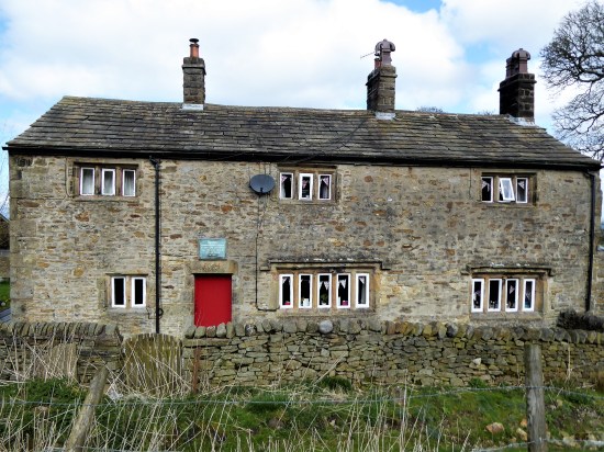
It was alarming that my car radio suddenly switched from Radio Lancashire to BBC Cymru as I turned off the A6 towards Dolphinhome in deepest Lancashire. Had I taken the wrong turning somewhere down the road? it turns out their frequencies are very similar, still a bit strange. I was on route to the heart of Bowland not Bangor. Tarnbrook’s few houses lie at the end of the road alongside the northern branch of the River Wyre. They are part of the Duke of Westmorland’s vast Abbeystead estate. I’ve covered this area many times before, most recently here in my Cicerone series. Parking along this narrow lane has always been an issue and the estate are discouraging us going past a suitable lay-by at the entry to the valley. I go along with this even though I know of a large grassy verge higher up the lane. These parkings are both mentioned in Mark Sutcliffe’s walk number 10 onto Ward’s Stone in the Cicerone Lancashire Walks guide book, my objective for today. It looked far off on the horizon.
What a day, clear blue skies and sunshine. Rare enough in these northern hills. But there is a cool easterly wind blowing even down here as I start my walk along the lane to Tarnbrook. I add a few extra warm garments to my rucksack. The quiet lane runs alongside the Tarnbrook Branch of the River Wyre and its joyful passage keeps my attention on the mile or so morning walk up the valley, and of course the lambs. I pass Ouzel Bridge leading to a farm. The Ring Ouzel, or mountain Blackbird, is found in the tree lined cloughs in the Forest of Bowland. Will I see any today, I have previously? 


Once into the hamlet I take the concessionary path straight up the fell into open access land, roughly following Tarnsyke Clough. Unfortunately not a Ring Ouzel in sight but there are plenty of lapwings and curlews flying around. This is essentially a Land Rover track to take shooters up to the butts on the fell. In the past, before the CRoW act, it was jealously guarded by the keeper living in the hamlet. Us climbers wanting to go up to the forbidden Thorn Crag, seen up on the right, often resorted to devious tactics, walking up a longer, but permitted, way to the plateau and then dropping down to the crag. We came unstuck one day when my climbing partner uncoiled his new rope, a fluorescent yellow. We could be seen from Blackpool never mind from the keeper’s cottage in Tarnbrook. Session over we would walk boldly down the estate track knowing we would be rudely accosted but also knowing they would have to let us out at the hamlet, stalemate. Things changed with the implication of the access agreement, the same gamekeeper who had sworn at us the last year now wished us a good day. The worm turns. There are no confrontations today and I just plod on upwards at my steady pace. I can’t believe I used to carry a bouldering pad up here. 

Thorn Crag and boulders.

Looking back down to Tarnbrook with Hawthornthwaite Fell behind.
I reach the ‘Luncheon Hut’, park your Range Rover here sir. 
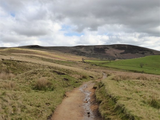
Onwards, I ignore the track off to the right and continue on to a division of tracks not specifically stated in the guide. It mentions contouring to the left, I somehow ignore this and follow the tempting main track upwards to its terminus, SD593578, and then pick up a fainter path linking a series of shooting butts rising up the fell. All very pleasant although the modern butts resemble WW1 fortifications. I am obviously wrong but take a compass bearing on the trig point and climb onwards. With relief the conspicuous weather station up here comes into view, I was then only a few hundred metres from the summit. It would all be far more difficult in mist. Probably would have been better to stick more closely to Mark’s directions.

End of the road.

Old pony track.

Grouse bunker.

The Fylde plain and Morecambe Bay lie down below, all a little hazy, as I reach the trig point, 560 m. The Lakes and northern Pennines were imaginary. By now the wind was almost gale force making any movement awkward. Fortunately there is a gritstone boulder, the Ward’s Stone itself, nearby behind which I cowered and added more layers of clothing. I used my spare balaclava to keep my cap from blowing away. Even with two pairs of gloves my hands were frozen. I was the only person out on the fell which was probably good considering my appearance.

560 m trig with nearby Ward’s Stone.

Grit Fell to the west and Morecambe Bay.

Over to Caton wind farm with the Lakes hiding behind.

Ready for battle at Ward’s Stone.
Half a mile across the sea of peat was another trig point one metre higher, so at 561 m the highest in Bowland. Why there are two so close together I can find no reason. All is Bowland emptiness to the east, except for Ingleborough’s distinctive summit across the Craven Fault. The book says head for Ingleborough, but I found a vague path going to its right and meeting up with a fence line that comes from nowhere. It’s all too easy in clear weather like today.

Heading just right of Ingleborough.


Queen’s Chair.
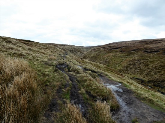
The going was good to firm on what after rain can be a quagmire of peat. The fence gave way to a wall, which gave me a bit of shelter from the wind. Another fence lead me down the fell. The Three Peaks remained unclear but ahead the remote Wolfstones and White Hill were obvious. These latter two are rarely visited trig points in deepest Bowland. Having said that not a lot of people come this way, the path along Ward’s Stone ridge is not heavily used.

The wall with Distant Pendle. I was having difficulty holding the camera steady.

White Hill.
This part of the fell was being used as a seagull roost, and I was dive bombed a couple of times. Judging from the number of gulls this won’t bide well for vulnerable eggs and chicks of Lapwings or Curlews. 
Suddenly I was onto one of his lordship’s roads coming over the hill from the north. This took me all the way down alongside the upper Tarnbrook Wyre in Gables Clough to the valley bottom. Farmers were busy with their sheep and lambs. 


In the hamlet the estate houses were being done up for a new lease of life. I remember a few years ago talking to a lovely old gentleman outside his house. He had lived there all his life and was the last resident still there. it will be interesting to see how gentrified the place becomes with new residents moving in. 

July 2014.
It seemed a long trudge back along the lane to my car. The extra road walking brings the mileage up to 10, more than the 7 1/4 stated in the guide. With hindsight, given the strength of the wind, it would have been an easier day in reverse.
***
This is what you may find on shooting estates. A snare cage trap on a log which is meant to kill predators such as the stoat or weasel. The problem is that other small mammals can easily enter and if the dimensions of the entrance are not correct so can larger animals. All very nasty to my mind. You wouldn’t want to put your hand in one! They make a resounding loud snap if touched with a ski pole.

***

BOWLAND.


 A new path has been fashioned from the top of the Barley steps to the trig point. I must admit it blends as well as possible into the plateau and must save a lot of erosion. There is also a new stone shelter built into the nearby wall. Once through the wall as if by magic everybody disappears, and I have the whole of Pendle Moor to myself. There is no wind today, so it is almost perfect silence apart from all those soaring skylarks.


 I couldn’t resist a decent hill day as the weather remained fine. All change next week. ‘Head east old man’ was my mantra as I sped along the M65. Everyone else was going west to Blackpool or the Lakes. Boulsworth Hill my objective. So far so good, but the last chapter of Mark Sutcliffe’s Lancashire Cicerone guide would have had me parking above Wycoller. If there ever was a honeypot then Wycoller deserves that title. A secluded village of agricultural and hand loom workers in the C16th to C18th. Along came power looms in the C19th in nearby Lancashire towns and the population moved out. By 1896 the majority of people had moved away from the village, and it was virtually deserted. But a renaissance occurred in the mid C20th, the area was incorporated into a Country Park and people started moving back into the village renovating the properties. I well remember Longridge acquaintances of mine telling me of their plans for one of the houses in the 70s. I suspect you would have needed a bottomless purse to go ahead. For more information look at


 A good start to the day, although by now it was after noon. The expected crowds were milling around in the hamlet. Crossing and recrossing the series of


 I have a few ideas for some hilly walks now the weather has improved, but they would involve travelling on the busy Easter roads, so I manage to procrastinate the morning away. Let’s just stay local and have a wander up Longridge Fell checking out a few bird habitats at the same time. I’m keen to see the Great Crested Grebes performing their mating dance on the little reservoir at the top of the village. This is where I park my car. Craig Y Longridge is busy with climbers.


 The clocks have changed, but my body hasn’t caught up as yet. Today had a sparkling alpine start and promised to be the best of the week. I struggled to get up having lost an hour somewhere. But with the minimum of faffing I’m away by 10.30. It only takes me a half hour to drive out to Dunsop Bridge. I know the sun doesn’t set tonight until after 7pm, so there is no rush, that’s the way I like it.


 The lime kiln gives a clue as to the bedrock hereabouts, but I shall soon be high in gritstone country.
 The track soon peters out, and I’m left on boggy pathless territory forever upwards. This is designated as a bridleway, and I remember coming this way on a mountain bike 35 years ago with my son. No chance now. This area is isolated from the usual Bowland haunts, and I’m surprised to meet three walkers descending the pass. A friendly trio and we exchange banter. They have driven up from Manchester, preferring this area to the crowded Peak District. They soon become a dot on this vast landscape as they descend towards the Trough Road and I struggle upwards. Across the way Totridge Fell keeps its head above most of the fells around here.


 Looking back I was surprised to see how steep and craggy are the northern slopes of Whin Fell. At Brennand Farm (notice how it complements Sykes Farm passed earlier) all is pleasant with newborn lambs in the fields, no Spring walk is complete without some lamb photos. On down the Brennand Valley and then strangely back upwards to join Whitendale.


 I’m tempted to go off down Fernyhalgh Lane past the old school (where my children started) the church and Ladywell Shrine, a shortcut back to Savick Brook. But no, I need the mileage and the day is fine, so I continue on the road whilst it is virtually traffic free. There are some fine houses along here as well as the original farms.
 Crossing the M6 motorway I stop to watch the southbound lanes coming to a standstill., a well-known black spot. Preston Bypass, as it was known then in 1958, was the first motorway to open in the UK. Since those days it has been incorporated into the M6 with new junctions and carriageways. I try to avoid driving on busy motorways with their frequent hold-ups and after my frightening experience of breaking down last year on a ‘smart’ section of motorway that has been reinforced.


 This week I have been alternating short walks and flat cycle rides with nothing of note to report. Everything came to a standstill yesterday with the collision of cold winds from the north with a front from the south. Amber warning. My son cancelled a lunchtime visit from Manchester and I watched the snowflakes falling in the afternoon. During the night things must have turned nasty as today I woke to a couple of inches of snow. (The radio told of far worse conditions in the Pennines) It was interesting to try and identify the tracks across my back garden, one doesn’t know what transpires in the night. Something I should resolve either with sitting up into the wee hours or more likely installing a motion detecting camera.


 As I approached the west end of Morecambe I was intrigued by a large building set back from the front. The building now known as The Battery once marked the boundary between Morecambe and Heysham. (in 1928 the two districts merged). In the nineteenth century the site was occupied by an old mill and the area was later used as a firing range, with an artillery battery stationed there because of fear of an invasion by the French. The mill, then known as The Roundhouse, was used for storing ammunition. The Battery Inn was built in 1863 and in 1900 it expanded to become The Battery Hotel, later acquired by Thwaites Brewery and functioned into the 1980s. It has recently been bought by a property developer for conversion into luxury flats. I’m not sure whether much progress has been made.

 And what’s more on the other side of the road a series of artistic panels brightening up an otherwise drab development hoarding at the former Frontier Land. I now remember Eunice from the Mouse House mentioning them


 I may have used this title for a post in the past. Whilst fellow bloggers are exploring Manchester, White Nancy, Covid and Wildlife crimes I’m content with a walk around my local lanes. After my drubbing, is that a word, the other day on the Guild Wheel cycle route contentment is the prime objective. I live on the edge of the countryside, but only just with all the new developments, so for many walks I don’t need my car – just set off from the front door.

 I stop to talk to a farmer about the winters we never have these days. (tempting fate I know). Along comes a car which stops to reveal a dog walking friend fresh off the fell and heading for a nearby farm café, a good catch up ensures. I’m then admiring the hedge layering skills along the way and am lucky enough to come across the skilled labourer himself. A chain saw now makes the labour easier, but he has to be careful with the final close cut. A bill hook finishes off the branch severing, leaving a slender life giving, bent over, horizontal, stem for further growth. The whole process is to keep the hawthorn hedge thick at the base and stock proof in the future. He seems happy in his work and as he says ” jobs a goodun”


 Not bad for a local walk of 5 miles.


