I’m lucky to be surrounded by accessible fells giving good local walking, but at the moment I’m restricted to cycling, so I’m making the best of any opportunity for exercise whilst the sun shines. Today’s ride took me around the Bleasdale lanes without much climbing up the fells. However, I was surprised that when I plotted the route later, I’d climbed a thousand feet. It didn’t feel like that, there must have been lots of gradual ascents in low gear. Throughout the day I was treated to fine views of the Bleasdale Fells, Beacon Fell and on the run into home Longridge Fell.
Within four miles I was cycling through Inglewhite with its C17th market cross and then down across the River Brock into Claughton, a scattered parish by the motorway. Somewhere in the middle of it is Claughton Hall, but I only saw the western gate lodge. Up the lane was a medieval cross, at least its gritstone base.
On the map there was a lane taking me in the right direction, but it turned out to be trickier than I thought, and I ended up walking the last uphill half, all very pleasant though.
I was soon on familiar roads skirting the Bleasdale Estate, with the fells all around me.
The ‘back’ of Beacon Fell.
Fairsnape and Parlick.
I stopped for a break and was joined by a party of horse riders from a nearby trecking centre. In the field to my left were dozens of dogs running about, some sort of canine day nursery. The staff didn’t seem very friendly when I stopped to look, perhaps they are wary of dog thefts at present.
Next it was mainly downhill on convoluted lanes with Longridge Fell ahead. I live at the base of the fell, so no further climbing was needed.
The sun was a cold November grey by the time I pulled into home. Another simple 20 miles through Lancashire’s countryside.
Another sunny-day journey with the over-the-hill cyclist.
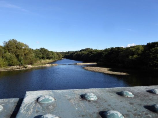
As I swooped down into Ribchester, at the back of my mind was the thought that later in the day I would have to regain all the height, plus more. The morning was perfect with blue skies and sunshine, and more importantly to me in my new cycling guise – no wind. A pause to look at the River Ribble at Ribchester Bridge and then along the south side of the valley. The Marles Wood car park looked busy with families setting off for a riverside walk. I enjoyed the quiet lanes that eventually wound into Whalley on the banks of the Calder. I’ve always been intrigued by the row of cottages as you enter the village, today whilst I was taking photographs a couple of residents emerged and told me that they had been built as workers accommodation by a nearby hall. They had no explanation as to why there were two levels of access.
Dropping into Ribchester.
The Ribble, at Ribchester Bridge.
Old St. Leonards Church, Langho.
Whalley bound.
Terrace Row.
River Calder and that viaduct.
Whalley centre.
My favourite café in the village was closed, so I just carried on towards Mitton with its three inns, a hall and a medieval church which I’ve mentioned before. A fisherman was casting in the Ribble with proud Pendle in the background.
Medieval church and Mitton Great Hall.
Talking of fishing, the last time I passed this way the Three Fishes was closed but in recent months it has had a makeover and reopened under Michelin-starred chef Nigel Haworth. He is hoping to make it the best pub restaurant in the area, judging from the prices, I won’t be visiting soon.
The road ahead gave a rather disheartening view of Longridge Fell, my next objective. But first I crossed Lower Hodder Bridge with Cromwell’s Bridge adjacent, you can’t pass it without another photograph. This was the lowest point of the ride and I now had to climb 600 ft back up onto the fell, steady was the word. Once up there, I had a switchback ride all the way back into Longridge and a hot bath to ease my aches.
Kemple End, Longridge Fell.
Cromwell’s Bridge.
Longridge beyond the reservoir.
***
A couple of extras –
Whilst I was climbing up the fell earlier, I had passed the well-known Pinfold Cross. This is what I wrote last time – The Pinfold Cross is a memorial to a former servant at Stonyhurst College and fiddler, James Wells. It was erected in 1834 at Stockbridge after he died in a quarry accident. On the front is inscribed the legend, ‘WATCH, FOR YOU KNOW NOT THE DAY NOR HOUR.’ Above this is written, ‘OFT EVENINGS GLAD MAKE MORNINGS SAD’. On the left is ‘PRAY FOR THE SOUL OF JAMES WELLS’ and on the right, ‘DIED FEB. 12TH, 1834′.
This is one of a series of crosses associated with Stonyhurst College whose grounds I have mainly skirted today. I did pass one of their gates and had time to ponder the school’s sign.I suppose times have changed and most primary schools now have a pre-school section. It is said that it helps children integrate better and prepare them for the learning experience to come. Oh! And it also provides a baby sitting service for busy parents out at work. What stuck me most was the 3-year-old reference. I couldn’t get it out of my mind and I imagined all these little children being abandoned at the school each day, God forbid if they were boarders. I’m sure it is not as bad as that and the toddlers have a great time.
Lily Allen, whom you may not be acquainted with, wrote a song expressing her own child’s anxiety left at home whilst Mum sang around the world. We have to be careful how we nourish our young offspring. Needless to say, I was humming the tune for the rest of the ride. Here is a version of this touching song where she is accompanied by Jules Holland – I’m only three.
Do you remember those heady days of ‘lockdown’ when the rules of travel had us all baffled? This little peninsula on the edge of the Lake District always has me wondering which county I’m in – I could at one stage travel to Silverdale but not to Arnside 3 miles away, Yealand Conyers but not Beetham up the road. Sir Hugh, my friend living in Arnside, had agonising decisions to make. Could he be fined for walking 3 miles south? Well, those days are over for now, so I’m happy to park up above Arnside for a cycle ride around the peninsula, one quarter of which is in Cumbria.
Of course until 1974 Arnside was in Westmorland, with parts of Lancashire across the water in the Lake District, but that’s another story…
Enough of the waffle, let’s get on the bike and go. Well, I don’t go far before stopping to explore a bit of Arnside. It has recently been featured on TV in a programme about coastal villages. The programme is worth a watch on iPlayer for the history it portrays and some fine drone footage. I pause on the front to gaze across the sands and imagine the dangerous tidal bore coming in.
As I write this, I hear of the death of Cedric Robinson, the Queen’s Guide to crossing treacherous Morecambe Bay for 56 years at a salary of £15 per year. I always regret that I haven’t done the crossing, I was booked in on a charity walk three years ago, but flooding made the channels dangerous, and my event was cancelled.
I come across some curiosities –
There is a water fountain dedicated to a young boy who died, aged 4, in 1903.
There is a clock tower dedicated to a Rev. Bamford and family, who lived and worked locally at Oakfield School, 1895-1935.
What must be one of the shortest piers in the kingdom was constructed in 1870, following the building of the railway viaduct in 1857 which stopped ships going up the Kent to the port of Milnthorpe. Across the road was the original port’s Custom House, highlighted in that BBC’s programme. Time to move on, I headed out towards Milnthorpe but turned off onto quiet lanes through the Dallam Hall Estate. They have a herd of Fallow deer here, but today they were being camera shy. The sounds of gunshot on the estate made me feel uneasy. Soon I was dropping into Beetham, with time to have a look around St. Michael and All Angels Church. The tower is reputed to be 12th century. The interior was interesting with some superb carved wooden Victorian chancel screens and a tomb from 1490 with two stone effigies believed to be Sir Robert Middleton of Leighton Hall and his wife Anne. This tomb was damaged in 1647 by soldiers of Fairfax in the Civil War.
Across the road was the C18th post office and the C17th Wheatsheaf Hotel. The steep hill out of Beetham up to Slack Head defeated me, the first of several today. I was then faced with an even steeper hill into Yealand Conyers. At the top was the old school (now a hostel) and Quaker Meeting House from the C17th. George Fox preached here in 1652. The simple graveyard of the Quaker burial ground was a delightful, peaceful place, so much more edifying than the ornate tombs in other graveyards. Out of interest the list of recent burials showed the majority to have been well advanced in years, maybe I should look into Quakerism – simplicity, integrity, equality, community, and peace. I’m already half way there. The three limestone Yealand villages occupy an elevated position and came into prosperity in the C17 with flax and hemp industries.I have never visited nearby Leighton Hall.
Top of the hill!
The old School.
Quaker meeting house, 1692.
It was mainly down hill into Warton, another village of C17th cottages. At its heart is the George Washington Inn, the Washington family having ties to the area in the past.I couldn’t resist a look into Warton Small quarry, a once time popular roadside climbing venue. It looked overgrown today. Farther up the road. I had to push, is the much larger Warton Main quarry, scene of some epics in the past. Most people avoid the scary long routes, 150ft, on the wall, but a pair were busy today on the upper tier where there are some safer bolted routes.
Warton Small quarry.
Warton main quarry.
Once I’d got my breath back, I enjoyed the switchback road with views over Morecambe Bay. On past the much photographed chimney at Crag Foot which was once used to drain Leighton Moss, home of the Bittern. Some more walking up hills and then I was in and then out of Silverdale. As I tired, I took less photo opportunities, but I couldn’t resist stopping at the little cove for a view across the bay to Morecambe Power Station once again. On the road below Arnside Knott I have a glimpse of the C16th fortified Arnside Tower before I reach the outskirts of Arnside.
Once back in Cumbria I called in on Sir Hugh the master modeller. This was a blessing as he plied me with tea and a wonderful Banana Cake, courtesy of his son William.
Another interesting Lancashire ride plucked from the bikehike cycle routes map, utilising NCR 90 and 6 plus some other bits I made up on the way. Don’t forget, by clicking the pictures may be magnified.
I’ve been reading a book over the last few nights, ‘Lancashire Magic and Mystery’ by a Kenneth Fields. It is far more than the mysterious, delving into the history and culture of the Red Rose County. I’d never heard of Plough Sunday before, a celebration of the start of the agricultural year in the first weeks of January. The book informed me that in agricultural parishes, a plough would be taken into church for blessing. This morning I found myself wandering around the grounds of Winmarleigh Church, St. Luke’s, and there by the entrance was a plough. I wondered about the connection.
I had stopped initially because of a mausoleum I could see in the churchyard, it was dedicated to the Reddaway family of Winmarleigh Hall who had been instrumental in the church’s construction in 1875. Lord Winmarleigh, paying the renowned Lancaster architects Paley and Austin for its design and build. He lived across the way in Winmarleigh Hall.
Surprised to find the church door open, I stepped inside. A long nave took my eyes to the chancel, with an impressive organ in the south porch. Whilst I was going forwards, I surprised a lady engrossed in her church duties. We chatted away about the church and its past. Her main concern was the financial support for the church in a small community. I brought up the topic of ‘Plough Sunday’. She remembered, as a child, ploughs being brought into the church but now said that a tractor with a plough draws up outside to be blessed on Plough Sunday. What a wonderful piece of history. (The plough turned out to be a seeding machine)
.
I was on a cycle ride from Garstang, on the Wyre, to Pilling, bordering the Lune. It was all fairly flat drained land, and being so open the westerly headwind seemed troublesome. Once I had turned the corner and was heading to Cockerham, my pedalling became much easier and the miles slipped by. A sign said ‘kill your speed, not a cyclist‘. It didn’t seem to make any difference to the rushing motors. Anyhow, I survived into Cockerham and soon escaped onto a quieter lane signed optimistically ‘The Lancashire Cycleway’.
Dodging around the main road, I was soon on a fast series of lanes over the Lancaster Canal, over the busy A6 and around the Bay Horse and railway. Hollins Lane took me past a friends’ house who were unfortunately away.
Zoom to Pilling.
Zoom to Morecambe power station over the Lune embankment.
Cockerham church.
I took the opportunity to have a look at Shireshead Old Church,1805. It is now used as a recording studio, yet the graveyard seems to be well maintained.
A steep lane took me down into the Wyre valley, where there are a group of fishing lakes close to the motorway. In the distance was the tower of Forton Service station, Grade II listed along with the churches I visited, and the spire of Scorton church, a well-known M6 landmark. Looming over all is Nicky Nook, 214m.
The River Wyre.
Nick Nook.
Do any pupils use this bus stop?
I cycled along a private road through Wyresdale Park which is now a wedding venue, glamping site and private fishing lake with a popular café for those climbing Nicky Nook. I ignored the café and continued into Scorton where there is a temporary takeaway serving coffee and snacks from a Citroën van. Refreshed, I was soon back at my parked car, no not the Mustang.
I didn’t have time to cross from Fleetwood on the ferry to Knott End last week, so today I’m cycling there from Garstang on hopefully quiet lanes. I was last at Knott End in March 2019 when I walked along the shore to Pilling, that was just before lockdown, and as I remarked in the comments “I didn’t hug anybody”. There has been a lot of water under the bridges since then, but Covid still worries me with our high infectivity rates and deaths.
The lanes I choose were indeed very quiet, with only the occasional agricultural vehicle. I was supposed to be on a National Cycle route 5 or 7, but there was never a sign. Pedalling along in my own world until I reached Pilling, a spaced out village with no discernable centre. I pondered at the naming of the Elletson Arms and Smokehouse. I wasn’t sure if it was still trading, the Golden Ball around the corner certainly wasn’t.
I took the lane past Fluke Hall onto the sea wall, where I hoped to be able to continue to Knott End. A wide coastal vista opened up with views across the bay to Black Coombe and the inevitable Morecambe Power Stations. Somewhere in the sands, the Lune empties into the bay. I could see figures out there, and then I focused on quad bikes coming ashore. They were cocklers, intrepid scavengers of the bay. Some arrived looking muddy and weathered, they weren’t the friendliest of people but explained how they rammed the sands and raked up the cockles. They had many kilograms of cockles to be cooked and exported through Europe.
I was able to cycle ‘illegally’ along the raised sea wall all the way into Knott End. Out there on the sands, as the tide came in, were hundreds of wading birds.
I couldn’t resist a drink in the café, which turned out to be a mini lunch, you get hungry cycling.
The ferry was running across to Fleetwood, but I kept to the tortuous lanes past Stalmine on this side. On my header photo the two lighthouses can be seen over there. I missed a junction near Out Rawcliffe and ended up at the Cartford Toll Bridge. I saved 20p by continuing on the north side of the Wyre. Eventually I came through Nateby back to my starting point by the Lancaster canal.
On the eleventh hour of the eleventh day of the eleventh month, I was parking up near Blackpool Hospital. I’d missed the silence and the bugle calls. Let’s remember the dead, but not glorify the war. And let’s not make a commercial event out of the date.
I was here to continue cycling up the coastal promenade to Fleetwood that I had started last week.
I was soon back on the front under the tower. Mid-week is much quieter on the promenade, in fact there are very few people about. Those that are seemed to be left over from the night before.
Off I pedal on the promenade northwards on multi layered promenades, some crumbling Victorian and others modern curving sea defences. The tide is out but coming in fast for the fishermen already setting up their stalls for an afternoon’s pastime. Past fading Norbreck Castle, lots of my photos show fading grandeurs on this stretch of coast.
On past Rossall School, past the drunken coast guards and onto the Fleetwood esplanade with its reminders of past disasters to the local fishing community. Fleetwood has two working lighthouses on shore. There is a third, now defunct, way out in the Wyre Channel. When they are lined up, a ship is on course to enter the River Wyre and the port of Fleetwood, when it was a port with a large trawler fleet. I’d intended catching the ferry across to Knott End, but the winter timetable was against me. I wasn’t prepared to wait an hour.
.
North Pier.
I’d also had intended riding back on local roads, but looking at the speeding traffic, I decided to just retrace my route on the promenade. That involved cycling into a headwind, but I was feeling fit and was soon back at the tower landmark.
The River Dunsop runs for only 2.3miles from the junction of its tributaries, the Brennand and the Whitendale rivers deep in the Bowland Hills, to where it enters the Hodder below Dunsop Bridge. At its head are weirs and fish ladders, trout should be heading up stream at this time of year. I’ve had a couple of forays onto the Hodder and the Lune in the last week in search of leaping fish, with no luck. My plan today is to check out the weirs at the head of the Hodder. The rain isn’t due until lunchtime, so I’m away earlyish.
Because of my troublesome heel I’m avoiding walking any distance and this is why the River Dunsop has been chosen. From the café in Dunsop Bridge there is a private road, recognised as a bridleway, conveniently running alongside the length of the river. In past times I would have cycled all the way from Longridge, but today the bike is in the back of the car until the car park is reached. The crowds of summer have gone and there are only two other cars parked up.
I pedal along happily taking in the scenery with Middle Knoll blocking the head of the valley. Despite it being a dull autumn day the situation is as dramatic as ever. The weirs I was aiming for are by the bridge at the junction of the rivers. I’ve come this way many times before and photographed it in the sunshine. Such as here.
You’ve guessed it — I saw no fish.
Not really disappointed, my chances of leaping fish were low, I cycled farther up the track to look up into the Brennand Valley which seems to go on for ever into the distance. I’ve not explored that area for some time. From the map there are possible tracks all the way to the remote Wolfhole Crag. Likewise, I then intended cycling up the right-hand track for a short distance to obtain a similar view into the Whitendale Valley, but a notice banned cycles. That is the way to more desolate moorland past the Duchy farm, which I last walked going through to Hornby on Wainwright’s Way.
The Brennand valley.
It was good to be in this wonderful place even if only on the humble road low down in the valley. It was a quick turn around and a gentle ride back to the café for coffee. The larch trees turning yellow lend some colour to the scene.
Back down the valley with rain approaching.
The bridge over the Dunsop.
‘Puddleducks’ cafe.
For anyone wanting to sample the wildness of Bowland without the commitment, this short journey up the valley, preferably on foot, is highly recommended. You can tell I’m passionate about Bowland.
Whilst driving home for lunch the rain started in earnest. The morning had been well spent.
One advantage of cycling the Preston Guild Wheel on a Saturday is that the little docklands railway is often running. The Ribble Steam Railway runs on a stretch of the lines that come out of a branch from Preston Station. At one time there were extensive lines serving the docks, but now the only commercial use is an infrequent goods train supplying a local Total bitumen plant. I’ve only ever seen the preserved trains on their short stretch of line. Recently was a special occasion as it was the maiden journey of a recently restored Furness Railway 0-4-0 steam engine no 20. This was originally built in 1863! What a sight and sound as it trundled along the track pulling a couple of coaches filled with waving enthusiasts.
I ended up in conversation with a couple from Bolton who often bring their bikes up here to cycle the guild wheel with lunch in the wonderful Boathouse café on Preston Marina, a stone’s throw from the wheel. They also had stopped to watch the train and were trying to take pictures for their grandson. Like myself, they find cycling on off-road trails far more relaxing and safer than our busy roads. We end up comparing trails as one does with fellow enthusiasts, although I have to admit to being an amateur. I do however recommend to them the trails in the Lancaster area, which I’ve been using recently. I give them a link to the bikehike mapping website that I mentioned in my last post. They have family living up in Halton, just off the motorway, so seemed keen to explore a little farther afield. I wave them goodbye, expecting them to quickly overtake me, but I never see them again. Just one of those pleasant encounters.
My most striking conversation was today. I was taking a break on the bench opposite Broughton’s War Memorial, in the now traffic calmed Garstang Road. Next week will be Armistice Day and there will be a service here to remember the fallen. As well as listing the dead from WW1 and WW2 there is a plaque dedicated to a James Towers a local man who was awarded the Victoria Cross for his bravery in the first world war. He died peacefully in 1977.
As I said I was taking a break here when a young lady cyclist pulled up for the same reason and we shared the bench. I wasn’t prepared for the story she, perhaps reluctantly, came out with. She was cycling the Guild Wheel for the first time in ages to remember her partner who died of Covid this year. It would have been his birthday today. He had been a fit young man, a runner and a cyclist, but ended up on a ventilator for two months before he finally succumbed. I gave my, probably pathetic sounding, sympathy and complemented her ride on what must be a difficult occasion. The conversation continued, it turned out she is a nurse who has worked throughout the pandemic. She wasn’t allowed to see her loved one in intensive care because of the restrictions, and this must have been heartbreaking for her, as at times she was on the wards in the same hospital. Wow, I admire her bravery.
We talk about the continuing pandemic, it isn’t over yet as you may have noticed, and her present nursing duties. She is far less critical than I at how our government has handled the crisis. She does however state the all too obvious fact, seemingly ignored by our politicians, that the hospitals are at breaking point. This week, three patients on ventilators were airlifted from a NW hospital to Birmingham to try and create room for more patients with life-threatening illnesses. I can’t comprehend the dedication that young women like her show in continuing to serve their patients in these desperate times.
She goes on her way, and I am left to contemplate what life has thrown at her.
To reach places farther afield, I put my bike in the car and drive to Wrea Green for a cycle ride on the Fylde. For several years I have used the website bikehike for planning walks using their OS mapping and measuring devices. The OS map was my main tool for walking and I ignored the other road map which I now realise highlights cycling routes from the National Cycle Network. The clue was in the site’s name. These routes try to use quiet lanes as well as some off-road sections. I find many roads frightening for cyclists, so keeping clear of heavy traffic is important for relaxed cycling. Out of interest for years I have supported the charity Sustrans which has been instrumental in establishing these routes with mapping and signage. All those squiggles on the map come up with plenty of ideas for my present modest cycling trips.
It rained most of the morning but was forecast to clear by lunchtime. I pedalled out of Wrea Green on the NCW90 but found it busy with traffic travelling fast and too close to me, so I was pleased when I turned off onto a minor narrow lane, the 62 signed to Lytham. This is the Fylde, flat fields and long vistas. Blue skies were pushing the grey clouds away. Ominously, the ditches on either side of the lane were full of water, and it didn’t take long before I came around a corner to be faced with a flooded road. I let a car go first and then pedalled through the 3 inches of water without getting my feet wet.
My arrival on the coast at Lytham coincided with a sudden heavy storm coming from nowhere. I squeezed into a shelter where two bird watchers were sheltering. Fortunately we got on fine and were still chatting away when I realised the rain had eased and it was time to continue. The iconic windmill on the green was looking rather sorry with some recent storm damage to its sails. Compare the picture of the mill with the one I took in 2017 whilst walking this stretch.
Whilst I was trying to photograph it, and yet keep my camera dry at the same time, a stunning double rainbow appeared across the front.
Pot of gold?
The storm passed as quickly as it had come and my attention was drawn to the views across the bay to Southport and beyond. Parbold Hill and Ashurst Beacon seemed to compete with Winter Hill for prominence. The tide was out but I didn’t have binoculars to identify all the wading birds on the edge. The promenade has been improved over the years and now provides a wide passage for pedestrians and cyclists. Only on a short stretch after St. Anne’s pier did I have to cycle on the road to bypass the extensive sand dunes. Once past the tram stop at Squire’s Gate the promenade is even more extensive with several ways and levels. This is where the FUN begins, and It started to become busier as Blackpool’s attractions loomed up.
St Anne’s genteel pier.
I weaved my way through the crowds and turned away from the prom just before the Tower to negotiate side streets of guest houses and flats. Police cars were flying around and there was an edgy feeling. The seedier side of Blackpool and I know, having worked here in the past. All was green again through Stanley Park and on past the Zoo. This was a branch of the 62 cycleway and wandered around fields on the edge of town. I was brought up short at this stretch of flooded path. How deep was it? I found out as I slowly pedalled deeper and deeper, with the water well above my bottom bracket. There was no stopping and I emerged thankfully 50 yards farther on with very wet feet. After I had reached a road at Staining the 62 rejoined the NCW 90 and it was all easy riding back to Wrea Green before the next band of rain blew in. My new bike computer said 24 miles, but you can’t always trust your computer.
I was sure when I passed this way before there was a fish ladder next to the Halton hydroelectric installation on the Lune. That vague recollection had brought the three of us along the banks today. I have not mentioned it, but last week Mike and I ventured down to the Hodder to try and see salmon leaping up its weirs. That was a complete failure, as had been my attempts last year, along the same stretch.
Not be defeated it was time for another try. We engaged Sir Hugh into our quest, even if it was just to get him away from his models. Meeting up at the defunct Halton Station, This should be an easy walk for my damaged heel. The rain stopped as we stepped out of the cars and incidentally started once more in earnest when we were just arriving back at them. Good timing.
We crossed the narrow road bridge built from the remains of an older rail bridge. Down below, the River Lune was running high and fast. I made my excuses then, saying there was probably too much water for the salmon leaping.
We walked past the housing developments near the old Halton Mill and forge and in half a mile arrived at the weir. I pointed out the fish ladder, but they were not convinced, and there were certainly no fish. I began to doubt my research from last year when a ladder and automatic fish counter were mentioned at this site. We poked about at the turbine house and admired the view of the L shaped weir with its rushing flood water.
My intention was to walk there and back, but somehow It was I who suggested carrying on and creating a circular walk via The Crook of Lune. I’m regretting that decision now as I sit with an ice pack on my heel.
Mike and Sir Hugh were pleased with the walk which was new to both of them, It’s difficult to take Sir Hugh somewhere fresh.
We spent time on the bridges over the Crook of Lune with the views up the valley and immediate vicinity. Something new had appeared on the eastern rail bridge — a multitude of fresh flowers adorning the railings. They certainly brightened up the scene and we pondered on their originator. It so happened that he was stood almost next to us and we were soon in conversation with him. From Transylvania and now Morecambe, he cycles here most days with the altruistic idea of brightening peoples lives. And he feeds the doves and pigeons. It’s a shame people go off with his best roses, but that’s altruism for you.
We couldn’t dally any longer and set off back along the south side of the river stopping at the weir again where there was a fish ladder but of course no fish. As I said we arrived back at the cars as the rain started and drove off to nearby Caton and the Ship Inn where we enjoyed, yes you’ve guessed it — fish and chips.
It’s still raining tonight and due to continue for a couple of days with more flooding, lets hope that may have some influence on the delegates at Glasgow’s international climate summit.
As I pedalled out of Longridge today I had no intention of going up Beacon Fell, but that is where I ended up, don’t ask me why.
Next week is the climate crisis meeting in Glasgow, so cycling and recycling could well be on the agenda. My carbon footprint today should be low providing I don’t switch on the central heating or eat any meat. Life is becoming complicated, with all manner of ways of going green. If we all recycled and if we all cycled instead of using our cars … but that is not going to happen. Pollution in our cities decreased drastically during the first lockdown, when nobody was going anywhere. Apparently the roads are busier than ever now. So what does our chancellor come up with in his budget to reduce global warming? A planned increase in fuel duty is cancelled because of fuel shortages and high prices. He has also cut the flat-rate tax on domestic flights to zero to encourage more flights. Those two decisions don’t look good for our green credentials in the international climate debate we are hosting next week. A case of business over environment. We will never reach our modest carbon reduction targets.
Anyhow, that is not why I’m on Beacon Fell. I’d been feeling rather guilty as I had opted out of a planned ride around the Guild Wheel yesterday with Martin. https://phreerunner.blogspot.com/
I’d woken up to monsoon rains and a dismal forecast, so I contacted Martin in Manchester to wimp out of a ride in the pouring rain. He agreed and I think cancelled his plans with others. By 11 o’clock the rain had stopped and there was a brief interlude of a couple of hours before the torrents returned — we would have been OK. Elsewhere in the NW there were floods and they have my sympathies. I still felt guilty and disappointed that we’d missed our ride.
Today looked like a repeat, weather wise, and I idled the morning away, but by one o’clock it was still just dry and bright, so I roused myself for a short spin around the lanes. Somehow cycling is not as spontaneous as going for a walk or run, all the faff of different clothing and oiling the bike etc. It is too easy just not to bother, especially for some brief exercise. But I need the exercise as I feel I’m becoming unfit and flabby from my enforced inability to walk far, Plantar Fasciitis, which seems to bring on red wine drinking and snacking.
The road out to Chipping seemed to fly along, maybe I had the wind behind me. Soon I was on quieter, more relaxed lanes and just went where the bike pointed. Before I realised it was pointing up Beacon Fell. So I dropped into my grandad gear and puffed my way up. I have been a little concerned recently by getting out of breath on any marginal incline, so I looked upon this ascent as a bit of a test. I’m due at my doctor’s practise for a proper test in the near future. Needless to say, I made it and pulled into the visitor centre/café at the top. It is half-term, so there are a scattering of outdoor type families taking to the pathways. The café is open as a ‘takeaway’ so I buy a coffee and sit at one of the outside tables. The coffee is not as good as usual, I wonder if they have changed suppliers and gone for a cheaper brand, I don’t say anything.
It’s nearly all downhill back to home but I come across a few interesting diversions which may show up on my phone camera.
As well as the gloomy global climate predictions I’m also concerned about the steadily growing Covid infections, hospital admissions and deaths. A close friend had a close encounter with a Northern Casualty Department last week, third world is how he described it. I’m just glad I’m booked in for my booster vaccination tomorrow.
Get recycling and save the planet.
Get your booster and save yourself.
A gloomy Bowland.
A gloomy Beacon Fell.
A gloomy BC.
Coffee.
In the highlands.
Not many of these about.
No way. I’ve been caught before. Don’t want to end up in casualty!.
I had noticed a sign off the Guild Wheel pointing to Kirkham, so today I set off to investigate. Everything is new around here. Holly Close, Bartle Meadows, Deer View, Waterside. etc. etc. I’m always intrigued by the names the developers come up with to try and create a feel for rural living while at the same time destroying the countryside alluded to.
I decided to park in Broughton to create a circular route using parts of cycle ways 62 and 90 out to Kirkham and back. Setting off on the familiar Guild Wheel I was confident of not getting lost in the maze of Cottam. A fisherman was sitting by the little pool somewhere in the complex, he was chatty and content to be out in the lovely sunny Autumn weather. As I pedalled off I pondered on the thought of retiring from vigorous exercise and taking up the rod. I soon came to the sign pointing to Kirkham. It didn’t lead me down a leafy track but along a new avenue, Cottam Way.
Along the way were a series of ‘sculptures’ which didn’t have any obvious relevance to their surroundings and for which I can find no information. There were two stone cairns, some stone heads and brick arches either side of the road. Anyone any ideas? There was also a cross which was inscribed with the relevant information.
The parish council has this to say about it…
Thomas Harrison Myres (1842-1926) was an English railway architect who designed stations and ancillary buildings, he and his wife had various residences including one at Cottam. Thomas was greatly interested in the restoration of road side crosses and succeeded in restoring sixteen throughout Lancashire. After his death, a fitting monument was erected to him and his wife Catherine at nearby Lea bearing the inscription.
“To the glory of God and in the memory of the pioneer of the restoration of roadside crosses, Thomas Harrison Myres of Lea Lodge and Catherine Mary his wife. The base of this cross originally stood 20yds from this spot and was removed here and dedicated July 28th 1929”.
The parish council also notes…
“ a sad event of 25th March 1952 when a test flight of a Canberra Mark2 was being made between Salmesbury and Warton by 29 year old Thomas Evans a very experienced and highly rated pilot. The aircraft was observed flying fast and low over north Preston when it suddenly went into a steep dive and hit the ground in what was at that time open farmland. The pilot was tragically killed, but no other casualties resulted”.
At the end of Cottam Way I had my first brush with the developments for Preston’s Western Distributor road which is being built to provide a link from the M55 to all the new housing on this side of Preston.
Cycles were allowed down Sidgreaves Lane. The Quaker Bridge carries the lane over the Lancaster Canal, for which the engineer John Rennie was responsible for in the 1790s. As was so often the railway followed close to the canals and the next larger bridge took me over the rails to Blackpool. The new road crosses here, I took the underpass and escaped into Lea a rather nondescript place.
Under the new road.
I cycled alongside the Springfields site still producing nuclear fuels. On the corner was an C18th windmill {now a pub} — a different source of power.
Another windmill was passed on the way into Kirkham, this one converted to living accommodation. Windmills were very common at one time in the windy Fylde.Kirkham has a long history from Roman times and developed as a weaving town from the 1600s using flax and then cotton. Today it is a bustling shopping venue with lots of independent businesses. Lowry painted Church Street on more than one occasion. I found the Queen Victoria’s Jubilee lamp and the fish slabs in the cobbled marketplace.
I wasn’t convinced as to the authenticity of the police phone box. St Michael’s Church looked resplendent in the Autumn sunshine, There was a hidden cycleway out of town, passing a simple art installation reflecting the town’s market status and the flax weaving trade. Back onto the open roads, I made good time through Treales and onto Bartle Hall where my route to Woodplumpton was closed completely by the Western Distributor works. I ended up back in Cottam on the Guild Wheel to Broughton.
Is this the last green space in the area, I hope it has protected status?
Feeling rather despondent after struggling to cycle around Longridge Fell the other day. I had been hoping soon to embark on a multiday cycle tour but now I was full of doubts, what would be my daily mileage. Realistically, I should be able to average 40 miles or more per day in hilly country, but I thought I was falling short of that. I’m getting older and I don’t have a scale to measure myself against, what I could do 30 or even 20 years ago doesn’t apply any more. I’m getting out of my depth.
I eventually stirred myself this morning as the weather brightened — time to test myself. From my house to the top of Jeffrey Hill is a mere 4 miles but is constantly uphill with 700ft of ascent. I aimed to cycle it without a break. Today’s route is in red compared to the circuitous blue of a few days ago.
I started slowly up through Longridge’s burgeoning housing estates. Summoning up some speed to pass the dog walkers, trying to not look out of breath. At the golf club the road was closed for drainage works but I squeezed through to remount and climb triumphantly to the summit of Jeffrey Hill just past the car park. Views of Chipping Vale and the Bowland Hills in one direction, the Three Peaks in the centre and Pendle in the other direction were too hazy for photography. A swoop down to the New Drop, now sold and being converted into apartments, and a right hand turn to follow the undulating road back past Craig Y, Upper Dilworth Reservoir and into town.
Approaching Jeffrey Hill.
Down to the New Drop.
Upper Dilworth Reservoir and The Fylde.
This took me just over an hour and I felt quite pleased with myself, slow but steady. I wouldn’t win any race, but I had proved to myself that my legs and lungs still have it. I’m trying to convince myself that cycling is wonderful. My next ride — that road going the full length of the fell to Birdy Brow and the Hodder. Watch this space, not that it will be very interesting.
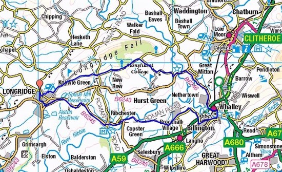
Blue skies, sunshine and calm conditions, perfect for a local cycle ride. Longridge Fell is my regular walking ground, but today I was going to circumnavigate it on lanes from Longridge. You will notice my post is titled ‘around’ and not ‘up’, I had no intention of cycling the high road over the fell, there are enough undulations on the planned circuit.
There was a chill in the Autumn air but by the time I arrived in Chipping I was suitably warmed up. The road I took follows the north side of Longridge Fell before dropping to Higher Hodder bridge. A steep little hill up past a once popular inn had me puffing and to be honest I was always a little out of breath on any incline from then on, I’m having difficulty getting cycling fit. Walking is so much more relaxing.
Great Mitton and its Medieval Church are skirted, then the road winds up through the Ribble Valley to Hurst Green. I’d planned a break here as there are seats on the village green. A walker with his Spaniel had bagged the best one, but I ate my banana on an adjacent bench before going over for a chat about all things local, a pleasant diversion.
Back in the saddle, I was soon back into Longridge, feeling rather tired from this modest ride. I had covered 22 miles but had ascended 1600ft in the process, there are no flat roads in the Ribble Valley.
And that’s about it. I didn’t take many photos.
Chipping.
Couldn’t resist another picture of Cromwell’s Bridge over the Hodder.
Hurst Green interlude.
On arrival back home this gigantic corkscrew had arrived on the building site opposite me. Earlier in the year we, the local residents, stopped Barratts, in the guise of homely David Wilson Homes, from disruptive pile driving on this site which is probably unsuitable in the first place for building on due to the shifting sands. They are now having to drill down 30–40 ft to find solid ground, don’t buy a house on Inglewhite Meadow.
I was already halfway around The Guild Wheel today when I saw this sign… I wasn’t sure as to why it was alongside the works for the new Preston link road but it fitted my mood for today. I usually cycle the Guild Wheel anticlockwise for dubious reasons, but today I had decided to reverse it and go clockwise, which is what the majority do.
That led to a debate in my head as to how we choose the direction for a circular walk or in this case cycle ride. Clockwise is the obvious choice as the name suggests, but other factors come into consideration. If a route is chosen from a guide book then we will naturally follow its instructions for ease of navigation, expecting the author to have planned the optimum way.
Planning one’s own route from a map there are choices to be made. Gradients differ depending on the direction, you may favour a slow gradual ascent to a steep short one or vice versa. But then the descent has to be taken into consideration, a climb involving scrambling is usually safer in ascent. Do you tackle the climbing at the start of the day when you are fresh or be faced with it as you tire towards the end? If road walking is part of the route again is this better sooner or later.
Weather plays a part. The wind direction should be taken into account to try and avoid walking into a gale on the high ground, have the wind at your back in those situations. If rain and cloud is forecast it is usually better to be lower down when it is at its worst. Unfortunately our variable weather patterns mean there is no certainty in making the right decision.
It is possible that views, particularly in the mountains, are supposedly superior from one direction than the other, so this may influence your decision. Also, the position of the sun will influence you if photography is important.
This is becoming complicated. No two people will agree on the best option and it is interesting when walking with friends how our choices differ. Compromise is usually needed or the toss of a coin!
Linear walks come up with similar dilemmas. East to west or west to east. North to south or south to north. On long distance walks once you have made your choice if the weather changes bringing wind and rain into your face it’s a case of c’est la vie.
Whatever your choice you always have the chance to repeat the route in the opposite direction giving a totally new perspective. Two for the price of one. Next time you are out on your favourite walk or ride do it the other way round.
As I said that is what I was doing today.
But not only that. I pass a sign every time I cycle round pointing to a Riverside Walk Via Bullnose and today I intended to investigate.
I cycled along a shady path and then came out onto the embankment overlooking the River Ribble. This is in fact the outer wall of the basin leading to the docks, the ‘Bullnose’, separating the dock entrance from the Ribble. The glory days of the dock, once Europe’s largest inland dock, are long gone, they closed for commercial use in 1981 and now used as a marina and leisure facility. I was able to go right to the end of the Bullnose jutting out into the river for views out towards the estuary.
The Bullnose is obviously popular with anglers, judging from the number there today. They fish for eel and flounder, and this angler landed a small flounder whilst I was chatting to him.
Usually there is a bridge over the locks at the end of the promontory but today the lock gates were open so I had to backtrack around the outer basin to the main swing bridge at the dock entrance. I was then back on the guild wheel to complete my clockwise circuit with views back over to the Bullnose.
October 9th. I can’t believe it is 16 years since the death of my father, aged 91. What would he have made of the world today?
Let’s remember him in music and in the genre he enjoyed. The original Horace Silver release on Blue Note was in 1965. An opportunity to experience the Latin piano beat with Joe Henderson on tenor sax. These may be new to some of you, but I can highly recommend a listen…
….and if you appreciate live jazz listen to this version, Copenhagen April 1968.
…or this much later 1996 performance. I’m spoiling you now.
…and to conclude, a tight modern version from Foo Jazz, not a piano in sight.
Sunderland Point is cut off twice a day by the tide, I double-check the tables before venturing forth today on my cycle. High tide is 12noon, so I can have a lazy start — don’t I always. My plan is to arrive at the coast after lunch, when the tide should be receding.
In the18th century Sunderland between Morecambe bay and the Lune was a busy port and ship building yard, with ships sailing to Africa and the West Indies. Cotton, sugar, rum, timber and the slave trade, it’s main stay. When wharves in Lancaster and Glasson Dock developed Sunderland’s trade finished. Many of the houses found here were originally warehouses associated with the port. In time, the point became known as Cape Famine. The hamlet’s two pubs, cargo warehouses, rope and block makers, customs house and shop have long gone. But in Victorian times it found a lifeline as a holiday and bathing resort, Little Brighton, But holidaymakers eventually preferred the bustling new seaside resort of Morecambe, with its smart buildings and multitude of attractions. Sunderland Point became the sleepy, out-of-the-way place it is today.
I park up at Halton bridge once again, unload my bike and take to the old rail line. There is something wrong — a strange noise coming from my pedals with each revolution. I stop to try to identify the source. Along comes a tattooed, long-haired ageing hippy on his city bike, “what’s the problem, mate?” His probable diagnosis was lack of lubrication. I stand there looking hopeless as he suggests going to his nearby flat to pick up the necessary tools and oils to solve my problem. In a few minutes he is back, we dismantle the left pedal and apply some much-needed oil. I can’t thank him enough. A good Samaritan has uplifted my mood for the day. I pedal off, relieved and immensely grateful.
The Millennium Bridge in the centre of Lancaster is looking stunning in the sunshine.
Easy pedalling has me into Morecambe in no time. The views across the bay to the Lakeland Hills are so much clearer than the other day. I arrive at the information board for the Way of the Roses, a 170-mile ride to Bridlington — now there’s an idea.
The promenade takes me to Heysham and onwards towards the docks. I thought I had spotted a lane going towards Middleton, but ended up in a massive caravan park under the two nuclear power stations. A friendly dog walker told me of a footpath out of the site onto Carr Lane. I found it and escaped onto the coastal lanes to Potts Corner. The end of the road on the edge of Morecambe Bay.
Holiday heaven.
Escape.
The tide was going out as I chatted to a fellow cyclist on a day out from Settle, I’m almost becoming one of the inner circle of cyclists. A kestrel hovers overhead. In the distance, a ferry was heading for the Isle of Man. Vast open spaces.
Some soggy, muddy and saline riding and pushing on a vague track led me towards Sunderland Point.
I arrive at the site of Sambo’s grave on this windswept peninsula. ‘Sambo’, a generic name, had arrived at the Point in 1736, a cabin boy. Probably abandoned, the little African boy perished in the port’s brewhouse. Deprived of burial in consecrated ground, his body was interred in this field, overlooking the sea. A local man wrote a verse about him 60 years after his death, which is on a plaque on the grave. The grave is regularly visited and is festooned with messages and mementos. A memorial to the slave trade.
A wall has been built around the grave and it doesn’t seem to have the desolate atmosphere I remember from my last visit. This is further diminished by nearby structures — a wooden bird hide and an art installation, Horizontal Line Chamber, a camera obscura by Chris Drury.
I entered the stone igloo and managed this image for you, an upside down coastal horizon. A narrow lane leads to the village of Sunderland. A man is working on the old pub’s brewhouse where ‘Sambo’ supposedly died. The pub itself stood on the edge of the harbour, its present owner sitting outside gave me all the history. A line of stone pillars denoting the extent of the wharf. Of course with the tide being out one doesn’t get the full impact of this having been an important port.
I go along to the southerly terrace of houses which have been converted from former warehouses. Farther on is Sunderland Hall built by a Robert Pearson, a date stone states 1683. I should have dumped my bike here and walked to the actual point — next time. A good excuse to return to this unique place, there is much more to explore.
Across the water is Plover Light guiding ships into the Lune. Built in 1847 it was lit by paraffin lights until the 1950s when it became fully automated. There is a Pathé News clip of a Mrs Parkinson, the then light keeper in 1948, going about her duties.
In 2016 it was badly damaged by a passing ship, the light had to be removed whilst reconstructing the stone base took place. I remember seeing it in its truncated form from Cockersand Abbey in that October with the light housing on the beach…
The afternoon was passing and it was time to ride across the muddy causeway back to the ‘mainland’. The mud flats on either side have an eerie appearance Once off the marsh I cycle into the little village of Overton, past the historic Ship Hotel and on to find St. Helen’s Church. It is on a hill south of the village, looking out over the Lune and Glasson Dock. Originally 12th century, it has had several restorations and alterations, but retains its Norman doorway. A signed cycleway alongside the Lune avoided the rush hour traffic. I pass the Snatchems Inn where in the past youths were plied with drink and then ‘snatched’ as crew for the sailing ships leaving the port in Lancaster. When they sobered up they would be halfway to Africa. It is now called the Golden Ball and looks in a sorry state. In the fading light I catch an unusual view of Ingleborough.
Interestingly, as I approach the Millennium bridge in Lancaster on the far side of the Lune was the wharf, warehouses, and Customs Office of the old Lancaster port, St George’s Quay, which put an end to Sunderland’s prosperity.
I have really enjoyed the peace and relative remoteness of Sunderland Point today, an antidote to our modern hectic lives. Oh! And my pedal was silent and stayed on to the end of the 25 miles.
*****
There are some dramatic YouTube drone videos of this windswept coast with the tides in and out. Such as…
Over the years I have posted several reports of cycling The Preston Guild Wheel. The last one was Dec. 2020. Now that I’m back in (enforced) cycling mode it was time for a revisit.
As usual, I park at the Red Scar Industrial Estate and unload my bike thus avoiding the increasingly busy road through Grimsargh. Going anticlockwise, I seem to pass most cyclists coming the other way, all with a cheery hello. There is a new stretch of tarmacked cycleway leading to Durton Lane in amongst new developments, avoiding the traffic on Haighton Lane. From now on it is one new housing development after another, some have been completed since my last visit with others half finished with brave new owners living amongst the mess. Frighteningly, any other available space, green or not, is fenced off ready for the bulldozers. It is all very depressing.
I enter the mature estates of Cottam where the cycleway weaves between houses. As usual, I’m not paying attention and come up against a gate I don’t remember, of course I was lost and had to backtrack to pick up the route. Along here I almost had my first ‘road kill. — a squirrel ran as close to my front wheel as possible without being squashed.
The wrong gate.
On through the University playing fields and out along the Ribble Link Canal. Here are more diversions where the M55 link road is being constructed, it doesn’t seem to have progressed much since my last visit.
I notice men with big camera lenses alongside the dock railway and with a little luck as I cycle the Ribble Embankment along comes a steam train for some extra excitement.
Preston’s Parks whizz by and I’m soon leaving the Ribble into Brockholes Nature Reserve, I didn’t stop to visit the ‘getting to know snakes’ encounter advertised for this afternoon. I’m always glad to get out of the saddle for a while for the push up the steep hill of Red Scar back to the crematorium and my car. But today on a whim I went round again, another 21 miles, albeit more slowly, there are more hills than you realise. I have a secret plan and I need to see if I’m getting cycling fit, the answer is not quite yet.
*****
In my head were the lyrics “round and round and up and down I go again” which I couldn’t place. Once home Google soon unearthed Let’s Twist Again, a big hit for Chubby Checker in 1960.
This is not to be confused with Twist and Shout which became a Beatles hit. They performed it at The Royal Variety Performance in 1963 when famously John Lennon said “For the people in the cheapest seats clap your hands and the rest of you just rattle your jewellery” much to the amusement of the Queen Mum. But I digress.
I hadn’t intended to come to Heysham but the day seemed suited to exploration. I had parked up again at Halton station and cycled into Lancaster on the old line, as I did last week on my trip to Glasson and beyond. My plan today was to continue on the 69 cycle way into Morecambe and then explore the coast northwards. I was soon crossing the Lune on the Millennium Bridge and then taking another old railway line, still cycle route 69, westwards.Two thirds along here I noticed a marked turning perhaps towards Heysham and on a whim diverted off onto what must have been a branch line of the railway. I was now in the hands of the sign setter. At first, I was on a cycleway between horse paddocks, but then I was directed into suburban streets, thankfully traffic free. Signs were followed until I lost them, and then I followed my nose into the inevitable cul-de-sac in Higher Heysham. A bit of backtracking and then a bit of the main road past the C16th Old Hall Inn down to the ferry terminal. Not the best way into Heysham.
At last the sea was now in sight. The road came to an abrupt end, but I was able to cycle through on a rough path to arrive at Half Moon Bay where there was a café, but every seat was taken. An advantage of cycling over walking is that it is easy to continue on to the next source of refreshment, though that didn’t quite work out.
Half Moon Bay.
Onwards and I found myself in Heysham Village. Lots of quaint alleyways, I remember from years ago a house selling potted Morecambe Bay shrimps, but couldn’t see it today. Soon I’m alongside St. Peter’s Church. It is thought that a church was founded on this site in the 7th or 8th century. Some of the fabric of that church remains in the present church. In the graveyard is an Anglo-Saxon cross and a stone grave. A track goes up onto Heysham Head to the ruined C8th St. Patrick’s Chapel. Most people come here to view the ‘stone tombs’ — a group of six rock-cut tombs and a separate group of two rock-cut tombs. Each tomb has an associated socket, probably intended for a timber cross. I have to say that today with a perfect blue sky and clear views they were magical.
I found my way back onto the promenade around Morecambe Bay. Views across the water to the Lakeland Fells held my attention as I approached the West End of Morecambe. I was soon alongside the 1930s art deco Midland Hotel. Somewhere along here is the proposed site of the Eden Project North, which is expected to bring back prosperity to this ageing seaside resort. I’d never been down the ‘stone jetty’ to the old lighthouse, it was along here that a fellow blogger described what she thought was the ugliest sculpture, I’m inclined to agree with her.
Also on the jetty is a bell that only rings at certain high tides. This bell is one of several around the coast of Britain connecting us with our maritime heritage and a timely reminder of climate change. https://timeandtidebell.org/#
“Bay surging, channels filling, sun setting, I ring, I sing. Listen in.” written by the local artist community is going to be engraved onto the bell. I must come back one day at high tide.
The promenade is wide all along the front so cycling was possible without endangering the crowds enjoying views. I don’t stop at every attraction, I came this way back in 2109 whilst walking A Lancashire Monastic Way, but I have to visit Eric Morecambe’s statue on a sunny day like this.
Commander C G Forsberg. Master Mariner and Marathon Swimmer.
From time to time I stop and gaze across the water to the Lakeland silhouettes and as I round the Bay, Arnside Knott and Grange become more prominent. “Best view in Britain” one of the locals tells me. I knew of a café at the far end of the promenade where I thought I would get a snack, but time had flown, it was now 3.30 and they had closed.
The main road had to be used to enter Hest Bank where I found a garage that sold coffee and pies. I sat outside, still enjoying the warm sunshine. It’s always a mistake to ask a local motorist for directions when you are walking or cycling. ‘Go down the road until the traffic lights‘ – no mention of how far that is. ‘Follow the signs to Slyne and at the T-junction turn left to Halton’. After the lights half a mile away, I ended up on the busy A6, there wasn’t a T-junction and I was almost back to the garage where I started. At least I was on higher ground and had a good run down over the M6 into Halton, with the Bowland Fells in the background, and over the narrow bridge to my car, the last in the car park.
There may not be many more days like this as Autumn draws in — bring me sunshine any day.
I thought I’d give this post a sexy title to boost readership. Not that I look at all sexy in my fading Lycra cycling shorts. There should be an age limit for appearing in public wearing Lycra, and whatever it is I am long past it.
I’ve driven up the motorway, coming off at Junction 36 and found the narrow lane leading down to a car park at the redundant Halton station. This is on the old Morecambe to Wennington line which closed under The Beeching Act in 1966. Route 69 of the National Cycle Network connects Hest Bank on Morecambe Bay with Cleethorpes on the East coast and uses this section of line from Morecambe to Caton. Off I pedal westwards on the 69 into Lancaster. The River Lune is mainly hidden and I don’t recognise much until the Millennium Bridge where the 69 crosses the river. I’m heading to Glasson Dock, so I stay on the south side of the water. There seem to be a multitude of cycle paths in Lancaster and just following my nose I end up under the castle with the priory church looking down on me. A few streets later and I find my way back to the river which is not looking its best, the tide is out exposing lots of mud. I’ll locate the correct way next time.
Halton station.
Soixante neuf.
Under the M6.
The canal aqueduct.
The new Greyhound and Millennium Bridges.
Priory church — getting lost.
Lost.
Eventually I’m safely on the old railway track heading to Glasson. Lots of cyclists are using this route, I keep leapfrogging various parties as we go at different speeds, and I’m frequently stopping to take pictures of the Lune estuary. I have walked this stretch in the past when I was connecting a Lancaster Monastic Way. It is interesting to contrast walking a route and cycling it. One misses the little details as you ride by and although everyone says hello there is no chance to chat, that is until you reach a café and then can delve into gears and stems. As I don’t know one stem from another, I avoid the busy cyclists’ rendezvous at Glasson and cross over to the little shop which has freshly baked pies and good coffee. Here I can talk to the mature couples who have motored here for a good old-fashioned afternoon out. And of course there are the fishermen with their ready tales of yesterday’s catch.
Glasson across the marshes.
Up the creek?
Lost forever.
Smell that coffee.
Pike?
A lot of the cyclists head back the way they came, but I’m in for exploring different options that I’ve spotted on the map. So off I go along the rough narrow track, you couldn’t call it a towpath, alongside the Glasson Branch Canal to meet up with the Lancaster Canal. Ahead are the Bowland Hills, looking splendid in today’s sunshine. An easy option would be to follow the canal back to Lancaster, but I’ve walked that stretch many times.
The Glasson Branch
Endless games of fetch the stick.
Junction with the Lancaster Canal.
So again I go my own way again, threading through Galgate and onto lanes crossing the motorway and leading into the hills. There is only one bit I have to walk up, and then I’m onto the lovely high level road to the scattered houses of Quernmore. From up here are views across Morecambe Bay to the Lakeland Fells with the Bowland hills rubbing at my right shoulder. I sweep down past the isolated Quernmore church and on to the entrance to Quernmore Estate at Postern Gate which I recognise from our ‘trespass’ on the straight line from my house to Sir Hugh’s in Arnside. I daren’t risk cycling through today so I take the busy road down to Caton and am soon back onto that rail line — Route 69.
Lancaster University, Morecambe Bay and Black Coombe.
Grit Fell.
Quernmore Church.
Postern Gate — tempted.
Down to Caton.
This last section back to Halton is impressive by dint of passing over two viaducts above the Crook Of Lune built in 1849 to carry the railway. This is a popular spot today with tourists, walkers and cyclists. There are stunning views up the Lune towards Hornby Castle and Ingleborough. Turner’s painting of the scene, pre railways, shows the original Penny Bridge carrying a road. This road bridge was rebuilt in 1889 and stands just below the East Viaduct. A long stretch in trees with little sight of the river has me back at Halton Station.
Eastern viaduct.
The Lune valley eastwards.
Crook of Lune road bridge.
Western viaduct.
Halton Bridge.
I go down to the river near the wrought iron lattice bridge built in 1911 from the remains of the Original Greyhound Bridge in Lancaster. Sitting quietly in the sunshine, contemplating the slow flow of water before hitting the motorway. I didn’t need that sexy title — this landscape has no need of titillation.
 I’m lucky to be surrounded by accessible fells giving good local walking, but at the moment I’m restricted to cycling, so I’m making the best of any opportunity for exercise whilst the sun shines. Today’s ride took me around the Bleasdale lanes without much climbing up the fells. However, I was surprised that when I plotted the route later, I’d climbed a thousand feet. It didn’t feel like that, there must have been lots of gradual ascents in low gear. Throughout the day I was treated to fine views of the Bleasdale Fells, Beacon Fell and on the run into home Longridge Fell.


 The sun was a cold November grey by the time I pulled into home. Another simple 20 miles through Lancashire’s countryside.