Tag Archives: Bowland

ZIG ZAGGING UP FAIRSNAPE.

The way to the zig zags.

From Bleasdale if the light is right one can see a zig zag track going up the southern slopes of Fairsnape. Today, Easter Sunday, the sun was strongly shining onto that slope and the way was not obvious but a look at the satellite map shows the track clearly from Higher Fairsnape Farm..Fairsnape is usually climbed from the outskirts of Chipping following tracks over Parlick but I have not used these zig zags and I thought today would be a good time to avoid the crowds. Sure enough when I reached Fell Foot the were already a dozen cars parked up, this is the spot where the paragliders start their trek up the hill. An insignificant footpath pointer on the corner led me into rough fields  where few go, but stiles some more substantial than others link up a pathless route which traverses round below Parlick to above Blindhurst farm.The sound of Lapwings and Curlews was everywhere, a hare popped up directly in front of me before disappearing into the distance. There seem to be an abundance of Orange Tip butterflies this year. There are new-born lambs and in the sky early paragliders. To my right is open access land [rough poor land that the landowners were happy to allow to be designated in the CRoW act] and it struck me that the colour of the land resembled the brown colouring on the 1:25,000 maps.

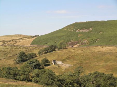
I dropped into a valley with a tributary of the River Brock and passed a green spot that would be ideal for a wild camp with my youngest grandchild if I could get him off his iPad. There was nobody about at Higher Fairsnape farm except new-born lambs. The buildings look old with mullioned windows and one wonders about the hardships of farming these remote places in the past and even now.

A signpost pointed the way on a concessionary path to reach the start of my zigzags. Once on the open fell I enjoyed a leisurely ascent up the well graded tracks, I always assume these tracks were for bringing peat down from the fells.

At one of the turns was the remains of a building, perhaps a shelter for the workers.

Years ago I can remember a similar structure with a disintegrating roof on the way up nearby Saddle Fell, it has now become a pile of stones but perhaps hides a sombre history.

On 26th March 1962 three siblings left home and travelled by bus to Chipping and walked over the fells, maybe to Langden Castle, on their return over Saddle Fell they were faced with severe winter conditions which result in the two brothers losing their lives due to hypothermia. Their sister Sheila survived to raise the alarm at Saddle End Farm. The brothers probably took shelter in the hut.  There was no Mountain Rescue Team in the area at that time so it was left to the police and locals to search, British Aircraft Corporation loaned their whirlwind helicopter to help. Shortly after this tragedy a South Ribble Rescue team was set up, now the local Bowland Pennine team.

  Above me were paragliders soaring the thermals and lots of people coming up the route from Parlick, I had seen nobody for two hours. My track came onto the plateau only a few hundred yards from the summit. Up here there is a cairn with Paddy’s Pole, a wind shelter and the trig point, 510m. I had a quick look around for a suitable bivi spot in the near future.

I was able to take a summit photo of a couple on their first ascent of Fairsnape and pointed out that the true summit, 520m, was half a mile away NE and that today conditions were perfect for visiting it as the peat hags that guard it have virtually dried up. I met up with them there later. the views were hazy – no Lakeland Hills or Three Peaks, Pendle and Longridge Fell were a blur.

520m summit.

A romp down the wallside and round Parlick. Looking back across Bleasdale towards Fairsnape showed no evidence of my zig zags. I walked below the popular spots for launching parapentes and many were still in the air. I passed a late starter walking up with his load.

The day was finished before lunch back at the road at Fell Foot.

*****


NORTHING 438. INSKIP TO LONGRIDGE.

January 27th.    7 miles.

This is long distance walking in easy stages designed for winter exercise. Todays stage actually finishes in Longridge, my home town, which is convenient for me if not for Sir Hugh who has to travel from Arnside, but it was his idea in the first place. At least today we meet up in the agreed destination, a good start. We are walking by 9.30 on a clear sunny morning with a strong cold wind at our heals. There must have been a lot of rain last night judging by the pools on the road – an ominous sign. We take to footpaths as soon as we can and end up in deep mud similar to where we left off last week. The stiles around Singletons Farm are virtually impassable, blocked by hawthorn, but we push through.Crossing a field we are confronted by the next stile leading into a lake, no way we can go that way so we retreat and hit the minor lane to Cuddy Hill [sounds Scottish] and the well-known Plough Inn. After all the frustrating obstacles I was ready for a drink but of course they hadn’t opened. Eventually we find the onward path and emerge onto a lane which took us over a canal. In the past we have both walked the The Black and White, Lancaster Canal.    but we didn’t recognise the location,

We were on the A6 for a short distance before crossing over onto tracks to end up in fields,  navigational errors had us back tracking to reach Jepps Lane. The A6 seemed like the transition from the flat floodplain of The Fylde to the pleasant countryside of the Ribble Valley. The wind by now had intensified and many of Sir Hugh’s pearls of wisdom were lost. I had never been down the lane to Barton Old Hall before, but it conveniently crossed the motorway for us. The Old Hall was hidden behind trees and the cluster of houses and conversions at the hall were rather depressing.

I think we were deterred from the actual path through the properties, but still found ourselves in rolling countryside alongside the proverbial babbling brooks. Time passed as we weaved our way through the pleasant Lancashire countryside. The Bowland Fells rose in the background and ahead was a glimpse of Longridge Fell.

We passed the stately Goosnargh Lodge, joined some local routes and reached Goosnargh Mill, not the best of conversions.

I was now on home ground and confidently marched across fields finding hidden stiles until we reached one that was in such a dangerous state we had to retreat yet again and find an alternative way. Worse was to come as what had been open fields was divided up by permanent electric fencing, the sort used for equine enclosures, with no regard for any public rights of way. Attempts at crawling under on the wet ground were not pleasant, so we took to dismantling the top wires to step over, there was fortunately no electric current. Reports to LCC  are on their way. A rather sour note towards the end of the day.

He who dares – SAS training.

Just before Longridge we passed Sea View cottages,  and yes you could just about see back to the coast where we had started SD 38.The road into Longridge is now surrounded on all sides by new housing developments, the Fell can just be glimpsed above the roofs. It is no longer the attractive, honest, little town that I moved to all those years ago.

*****

A MISTY BEACON FELL.

Normally I can see Beacon Fell from my house – but not this morning. A freezing mist hung over the landscape. Not to be deterred I wanted to walk up there and back, in deference to the weather and my late start I took the car some part way. I know these footpaths well as I often do this walk or a variation, it is in fact the first section of my Longridge Skyline Walk.

The snow was disappearing from the fields as I set off. Soon I was walking through the first of several developments where an original farmhouse with its surrounding barns has morphed into an expensive looking ‘hamlet’. This one is based around Higher Barker.

Familiar field paths [I didn’t need a map today] lead to the Cross Keys Inn where holiday type units have been built around the site, none ready for occupation in what is a speculative development. The Cross Keys was a farm-cum-basic pub run by brothers and known affectionately and ironically by locals as The Dorchester. What of its future?

The lane ahead is always soggy and today was no exception. I could hear a woodpecker in the trees of Whitechapel.

The sun was trying to break through the mist as I crossed fields to Crombleholme Fold another group of houses old and new. The sheep were surprised to see me emerging from the gloom.

Still no view of Beacon Fell which I knew was looming up above me.  The trees were soon reached and as I entered them a small herd of Roe Deer passed in front of me seconds after taking this picture.

The car park at the visitor centre was virtually empty and I was the only one in the cafe where I enjoyed a good coffee. To reach the summit I followed the latest version of the walking snake, this one is expertly crafted from stone so should be more durable than the previous wooden sculpture.

I had the summit to myself with tantalising glimpses of Parlick and Fairsnape Fells through the mists.

A newish path, there are many since the storms of last year, and a concessionary bridleway through deciduos plantings took me out of the park.

A field footpath led me down to the fishing lake/holiday homes of Woodfold, another development which seems to be enlarging every time I pass this way. Do these places go under the planning radar?

My next aim was Barnsfold Farm environs where more sympathetic conversions were carried out decades ago.

Then it was muddy fields to Bullsnape Hall and back to my car just as the sun finally burst through. The final stile was a challenge.

An enjoyable day from nothing.

*****

WINTER ARRIVES ON MY DAILY WALK.


The moon was still bright and large while I was having my reviving first coffee, always the best of the day.

Overnight an inch of snow had softly fallen and now in the morning sunshine all was glistening white, time for that short walk before going out for lunch. I try to put in a few miles most days even if it is only my  daily walk cum shopping trip.

Out past the white cricket pitch and up the lane with views to the Bowland Fells, rabbits had been out much sooner than I.

Fields take me onto the toe of Longridge Fell, around the icy reservoir road with views to Beacon Fell.

I arrive for a peep into Craig Y Longridge. Despite the snow the rock was in perfect condition in the sunshine and if I hadn’t other appointments I would have been tempted back later for some bouldering.

I was soon down through the town, a quick supermarket dash and home for a second coffee. Oh and the lunch at The White Bull in Gisburn was excellent, I think I had worked up an appetite.

*****

CROASDALE/BULLSTONES WALK.

                                               Looking down a murky Croasdale.

One seldom meets another person in upper Croasdale, but today the Salter Fell track was busy with contractors making repairs to a steep section of the road above New Bridge. The road, also known as Hornby Road, dates from Roman times as Watling Street, which ran from Manchester to Carlisle.  It was along this road that the Lancashire Witches were taken from Clitheroe to Lancaster, and in fact, the last time I walked it was following a long distance walk called the Lancashire Witches Walk from Barrowford to Lancaster. Back to today, I was with JD, both of us needing some exercise. A lorry was taking stone up to the repairs, and the driver told us of the cost to Lancs. County Council, who apparently are obliged to maintain the highway, for whose benefit I’m not sure. An awful lot of potholes around Longridge could have been repaired for less. The repairs were extensive and thorough but not lot of work seemed to getting done today. More stone was being extracted from the higher quarry which in the past had been used for the construction of Stocks Reservoir dam in the thirties.

Track repairs with one of the Lancashire Witches Walk tercet waymarkers.

It took longer than usual to reach the top gate where we left the track and headed uphill through the heather. Looking westwards are views of upper Whitendale and remote Wolfhole Crag, this is wild Bowland country. I found the tiny sheep trod that traversed to the first group of Bull Stone boulders where we had our refreshments. The day was rather dull but there was no wind and silence prevails up here. Looking down the wide valley of Croasdale a misty Pendle rose in the distance. I had resisted bringing up my rock shoes but now regretted it as the conditions were perfect. Big boots would not have stuck to the friction slabs.

Sketch of the same scene from the Bowland Beth book mentioned below.

For a taste of the bouldering up here, have a look at  https://vimeo.com/183222521

We wandered on below more rocks, all bringing back memories to me, though JD had never been here. So it was a great pleasure to show him the massive stone trough carved on the hillside.

We found the little trod heading down valley, and at the ford we decided to continue down rough marshland to look at the bothy and surrounding sheep-pens. About ten years ago, I spent a couple of nights here with my teenage grandson whilst we explored the surrounding fells. In those days, Hen Harriers were a common sight on these Bowland fells, which were an important breeding ground for these beautiful birds. Things have gone downhill since then, with more and more persecution of raptors on grouse moors where the shooting lobbies run roughshod. I have just been reading a little book about the short life of Bowland Beth, born near this spot. A thoughtful analysis of the plight of wildlife on shooting estates.

Bowland Beth. The life of an English Hen Harrier.   David Cobham.     William Collins.

The bothy was unlocked, but animals had soiled the flagged floor. It did not look an attractive proposition for an overnight stay now, but would soon clean up.

Onwards down the valley with a few stream crossings and then we climbed back up the road passing on the way the remains of the House of Croasdale, a 17th century farmhouse built on the site of an ancient hunting lodge. It would have witnessed the witches being taken across the fells.

Remains of House of Croasdale.

An interesting circuit as usual, although a little sunshine would have helped with the photos.

*****

THE WAY OF THE CROW. Fourth day, Lentworth to Postern Gate, Quernmore.

                                                               Clougha Pike.

Serendipity – whilst we were looking for ways into the extensive private Quernmore Hall estate blocking our ongoing straight line a car drew up and out stepped the daughter of the owners! A pleasant chat ensured and we had their contact phone number for possible further progress on another day. But I’m getting ahead of myself.

Today should be easy walking , paths and lanes keep close to our ‘line’. Last night I’d been kept awake by heavy rainfall, frequent showers and gales were forecast but we set off and enjoyed sunshine and a bracing breeze. A quiet lane climbed away from the Wyre valley giving us a gentle warmup. Opposite the Quaker Friends Meeting House a carved stone was placed close to the stile we needed, we conjectured as to its antiquity. Once across a couple of swampy agricultural fields,  we approached a ramshackle farmyard, Low Moorhead, with trepidation, dogs and obstructions looked imminent. Another carved stone took our attention. As it happened the friendly farmer was busy nearby and we ascertained that he and his wife had created the stones rather than some medieval mason, we congratulated him on their artistry.

Most of the day we traversed Daleslike farmland below Grit Fell and Clougha Pike, gritstone moors above with Morecombe Bay spread out below. Our incursion onto the rough fell, boggy reeds, was not succesful and we were glad to hit the road and subsequently return into pheasant woods. The ‘beast from the east’ had been active here and we picked our way through the fallen trees.

Our incursion onto the rough fell, boggy reeds, was not succesful and we were glad to hit the road and subsequently return into pheasant woods. The ‘beast from the east’ had been active here and we picked our way through the fallen trees.

The last mile or so was along a supposedly quiet lane leading to those private woods above Postern Gate, the only highlight apart from a rainbow above the green valley was Quernmore Church.

*****


THE WAY OF THE CROW. Third day, Arbour to Lentworth Hall.

Distant Ward’s Stone Fell.

First a moan…                                                                                                                                             The Countryside and Rights of Way Act of 2000 ( the CROW Act, not the crow we are following )  gives a public right of access to land mapped as ‘open country’  known as open access land. A large area of the Bowland Fells are so designated which should give some degree of freedom to roam on the moorlands. However not all is as it seems. The 1:25,000 OS maps highlight open access land with  orange shading but the areas do not always link up with the public rights of way, creating a problem of reaching the access area in the first place. There are actually some ‘islands’ of access land with no access! This morning we are faced with one of these dilemmas, the lane back to Arbour is private for the first kilometre [red dots] so the logical way into the access area is denied legally. Who came up with these walker unfriendly ideas? I’m afraid those powerful landowners had too much influence when the plans were being drawn .Anyhow here we are back at the Arbour shooting lodge in its remote setting, ready for another ‘up and over’. Today we have to climb over Stake House and Grizedale Fells. There is still no sign of the rhino. We take the opportunity of some shelter by the lodge to divest of some clothing before the sweaty climb. A vague track is lost and then found as we puff up the steep slope alongside a series of very posh shooting butts. This track in fact takes us to the unmarked summit of Stake House, 402m, where we can admire views of Morecambe Bay, the Clougha Pike, Grit Fell, Ward’s Stone and Wolfhole Fell group with  the Trough Of Bowland spread out below. We take a compass bearing to a pond which should be near the start of the track at Grizesdale Head. We are in the middle of a wilderness here though the going is better than we’d anticipated, short heather and not too much bog. The weather is changeable!

A hazy Morecambe Bay with another storm coming in.


Wilderness – on a compass bearing.


Out of nowhere a gate in the boundary fence appears and this gives us easy access to the landrover track we are relying on to take us off the moors. We do so in swoops down the hillside as the weather takes a turn for the worse, wind and hail. At the road we are glad to hide behind a wall for lunch and watch the lazy antics of some contractors trying to offload fence posts. I do not envy their work outside in these conditions.

Opposite is a private lane to Catshaw Farms which is right on our route line, we wave enthusiastically at farm workers who pass us but nobody seems bothered by our presence. Once at the large farm complex we are back on public rights of way. Catshaw Hall Farm dates from the 17C, grade II listed with mullioned windows. There was work going on today.Muddy fields drop down towards the River Wyre where many trees are down from recent storms.   At a side stream the path has been washed away leading to some undignified bum sliding to reach the newly reconstructed footbridge. The bridge over The Wyre is made of sturdier timbers.  I realise have been here before.

Steep slippy steps bring us into fields belonging to Lentwoth Hall, now divided into apartments.

The final lane with ‘walking’ trees.

This whole area of Abbeystead is part of the Grosvenor estate owned by the Dukes Of Westminster. It holds the record for the biggest grouse bag in a day. On 12 August 1915, 2,929 birds were shot by eight shooters. We have survived the day through their estate and will carry on no doubt to trespass further estates on our straight line. I’m glad we finished when we did as the weather became atrocious, it’s the first day of winter tomorrow.

*****


THE WAY OF THE CROW. Second day, Bleasdale to Arbour, Calder Valley.

JD seemed worried when I described the next leg of our straight line way – “it is extremely rough going, the game keepers are unfriendly and there are rumours of a wild rhinoceros”. Despite all that he agreed to join us on his recommended shortened version. The picture above was taken from his house when I picked him up in the morning, The Bleasdale Fells which we had to cross are to the left of the higher Fairsnape group. Beacon Fell is far left.

The car park at Bleasdale Church was busy with Sunday worshippers.

It was a glorious sunny morning as we used field paths into the heart of Bleasdale discussing our individual Saturday night’s exploits, I probably had the largest hangover, Sir Hugh had been consructing a cat flap and JD entertaing his family.

Donning extra layers when we realised how cold it was.

No that’s not the rhino but pretty scary anyhow.

After the isolated Hazelhurst Farm we found the beginnings of a land rover track that would, via a series of zigzags, take us steeply into the open access area and onto the fell top. We puffed our way up with frequent stops to admire the views over the nearby Fairsnape/Parlick fells with Bleasdale and  the Fylde below. Surprisingly and fortunately another quad track led to the remote trig point, 429m, of Hazelhutst Fell. We are on grouse shooting moors up here and much has been written about the persecution of other wildlife in this vicinity to try to promote the shooting fraternity. Whatever one’s opinions about grouse shooting I am strongly against the wilful and unlawful killing of our protected species. On this stretch of the walk we came across several loaded Fenn Traps which are legally only allowed for stoat trapping [killing] but are known to trap other species. These are lethal looking spring-loaded traps which could almost take the tip off your walking pole.

From the trig point there were hazy views across Morecambe Bay to Black Combe and Barrow. Taking a compass bearing we set off across the heather in a NNW direction and fortunately found another quad bike track taking us down past shooting butts so avoiding all the heavy going. After what I’ve said about the grouse shooting land owners we were thankful for their tracks. The final descent was vertiginous. The surroundings were reminiscent of a Scottish Glen and we found the bridge over the Calder to the Victorian shooting cabin of Arbour. This must be one of the best kept secrets of Lancashire.

We found a sheltered spot out of the cold east wind for lunch. There were no windows into the shooting lodge to see the rhinoceros head. The story goes that a rhino escaped from a train near Garstang and had to be shot, it’s trophy head being mounted in the lodge.

By now all the excitement was over and we had an easy walk out on the track alongside the River Calder.  We were back at Sir Hugh’s car much sooner than we’d planned because of those good moorland tracks. We will have to walk back in next time to rejoin our line.

*****


THE WAY OF THE CROW. First day, Longridge to Bleasdale.

I was apprehensive, walking in a straight line as possible would take us on unfrequented paths, would the way be feasible. We left the village down overgrown Gypsy Lane and shortly after found a gate secured by a cord, a veritable Gordian Knot. Out came Sir Hugh’s, I’ll blame him, Swiss Army Knife and we were through.

‘Gypsy Lane’

We passed the ponds, ‘figure of eight’ where my children used to go fishing without much success but I’m sure they had an adventure away from parental supervision – they never drowned so I must have been doing something right.

The next farm-yard, where I’d previously climbed walls to escape, was now well signed and we even had a resident directing us to the hidden stile ahead though the accompanying foot plank, couldn’t call it a bridge, didn’t inspire confidence.

The slippery plank.

We reached a farm gate on a public footpath which was securely padlocked, no Swiss Army knife could cope, but as if on cue a lady drove up in her battered pick-up and opened up for us. Remonstrating about obstructed footpaths didn’t seem to be appropriate. All was pleasant rural scenery with scattered farms, some in better condition than others.

The next problem was of our creation, contentedly walking along the tiny River Loud we were almost in someone’s back garden when we realised we’d missed our path but fortunately a gate allowed our escape onto the road.

The infant Loud.

Things improved as we headed closer towards the Bowland Hills and Bleasdale. We passed the small rural Bleasdale School and headed for the church where our car was parked. We were last here in gale force Ali. A group of fell runners were just setting off for a quick few miles and we exchanged pleasantries. Walkers, climbers , cyclists, runners tend to have a common background.

Is that an Ofsted verdict?

We had completed the first leg of our project with very little deviation from the straight and narrow and to be honest no serious obstacles except a lot of slippery stiles. Our way ahead over Hazelhurst Fell could be seen, the fell runner is pointing the way, but will there be any paths?

Yet another slippery stile.

***** 

THE WAY OF THE CROW. LONGRIDGE TO ARNSIDE.

My good friend Sir Hugh  [http://conradwalks.blogspot.com/ ] inhabits that lovely village Arnside whereas I have to put up with the gross overdevelopment of Longridge. For the last few winters we have had projects to keep us active in the shorter days. He has emailed once or twice with suggestions for this year but nothing has struck me as original, boringly I seem to have walked most of the Long Distance Paths in the NW. I came up with a counter suggestion – why don’t we draw a straight line between our houses and follow it as closely as possible. I know this idea has been used before, particularly successfully  by Nic Crane on his straight line Two Degrees West journey from Berwick-on-Tweed to The Isle of Purbeck. I seem to remember he gave himself  a kilometre leeway either side but had a lot of media support, I wonder if we could be even stricter. True to form Sir High has taken the bait and the line has been drawn.

It is the wrong time of year for backpacking so we will split the route into day walks. The distance as the crow flies is 26.5 miles but we will be lucky to keep it under 35 miles. No rules except keeping as close to the line as possible preferably on footpaths or quiet lanes, legal ground or not. There are some obvious obstacles in the way – the fells of Bleasdale, the Rivers Wyre and Lune, Quernmore Hall Estate and the M6. It will be a challenge overcoming them, lets get started.

THREE AGAINST ALI – AROUND BLEASDALE.

Most of the photos taken on my phone today are blurred. I was struggling to stand up in a 40-50mph gale, trying to keep my hood on as well as pointing the phone in the general direction of companions Sir Hugh and JD who couldn’t stand up either. After what I said in my last post about choosing the fine days to venture out, especially in the hills, today’s choice was obviously dubious in view of the forecast above. However unsteady my companions appear they have a resolution and resistance to be celebrated, we marched into the eye of the storm named Ali without a flicker of doubt.

Up and over the prominent steep Parlick along the ridge to the highest point of Fairsnape. So far so good, breezy but clear views. A newly flagged path soon disappears as we head into the peat bogs and evasive action is often taken to avoid the worst mires on the ridge. At the lowest point a vague path disappears down Fiendsdale towards Langden Castle, I think we’ll leave that adventure to another day. Our route westwards was again extravagantly flagged for some distance down the rake towards the bowl of Bleasdale. You could see the rain coming in on the storm and it hit us hard for the next hour, the wind was excessive straight at us and the rain in the air stinging on the face. Winter conditions within minutes and a good test for the waterproofs. It seemed a long way down. The usual erudite conversation from my companions was missing as we disappeared into our own worlds of survival. Salvation arrived in the valley as the worst of the rain passed, we could cope with the wind. We had more difficulty coping with some of the precarious stiles en route, Sir Hugh has two artificial knees and wasn’t happy with the contortions necessary to overcome them. Some situations when he was mid stride but hooked up to barbed wire became a mixture of uncontrollable laughter and panic as to his survival. We made it to Bleasdale church where a sheltered bench was gratefully used for sandwiches.

Vague paths across the bowl of Bleasdale led us to Blindhurst Farm through the usual stinking slurry and an outstanding farmhouse amongst the trash.

Despite our misguided attempts to reclimb Parlick we found some traversing sheep ‘tracks’ back to the car. The wind increased in intensity for our finale just to prove a point.

Not unsurprisingly we were the only car parked up.

Remind me next time to forge ahead and take some pictures from the front!

A day not to be missed.

*****

The map below is doubly important today, not only to show you the reader our whereabouts but also to give Sir Hugh an idea of where he had been.

MY DAILY WALK, [well almost daily].

The weather has not been good since my return from France, I feel Autumn is upon us.

It’s noticeable how often I comment on the state of the weather at the start of a post. Is that a British trait, am I obsessed with the climate or does it just reflect the close connection of conditions with my pastimes?  I remember when I was younger and outdoor time at a weekend was precious we would sally forth on walks or climbs whatever the weather. That would result in a fair share of days with no views and a good soaking on the hill or gripping climbs on cold slippery wet rock. Many of those occasions are vivid in my memory, proof of the importance to me of outdoor adventures and the companionships they bring. Character building was a phrase used. Now I take more heed of the forecast and try to choose the better days for my enjoyment or more likely head abroad to avoid the worst of our winter weather.

I’ve rambled off the subject.  I intend, now I’m free of the PMR stiffness, to  do a regular local walk most days to build up my fitness once again. How often have I said that? I have a 4mile circuit on my doorstep that suffices. Not only does one get some healthy exercise but also some physic benefits thrown in.  There are countless literary quotations extolling the virtues of walking, one of the simplest  –  “I have two doctors: my left leg and my right leg.”  G M Trevelyan.

I complain a lot, and will continue to do so, about the housing developments in Longridge destroying the character of the town but I’m still able to do this walk from my house into the country. Why drive anywhere in mixed weather when a walk can be accomplished from home.   A stroll down the road takes me past the cricket ground where today there was a match which I can stand and watch for a few overs. There’s something special about village cricket which makes it almost hypnotic to engage in, I think it is something to do with the enthusiasm of the players and the gentle clapping of the handful of spectators. Long may it be so. The lane I usually take up onto the fell gives a lovely view back across Chipping Vale to the Bowland Hills. The view is different with the seasons but gives a sense of space and nature within half a mile of leaving home. Today this was heightened by a pair of Buzzards wheeling and mewing above me. Time just goes by whilst you stand and watch. A glance over the reservoir at any other bird life – usually ducks and grebe. And a glance into Craig Y Longridge to see if anyone I know is climbing, not today with the damp conditions. My return down the town’s main street is more mundane but gives the opportunity for social engagement and grocery shopping.

A perfect little circuit, I’m off to do it again today when things will be different.

*****


DEEPER INTO CHIPPING VALE.

The Lazy Loud River.

There was a beautiful sunrise today which heralded good weather to come.

I’d arranged with JD to continue our intimate exploration of Chipping Vale by following as close as possible the little River Loud on its way to join the Hodder. My route was ambitious as from previous experience I know some of these paths are rarely walked. I was hoping for an easy day because of my recent stiffness and should have been concerned with the first stile we encountered off the road, awkward and overgrown.

Dr. Livingstone I presume.

To be honest we never really found a convincing path through the fields to the limestone Knainsley Quarry and once we were in its extensive area compass work was needed to get out. We emerged onto a lane bounded by expensive property conversions, lots of Range Rovers – that sort of place.

The next stile was impossible to negotiate, guarded by brambles and sloes, [reported to the authorities] but fortunately a gate took us into the same field to link up with a path that kept coming to more awkward overgrown stiles, but we slowly made progress to emerge probably on the wrong drive way at Loud Carr Side. All along this stretch we had wonderful views of the Bowland Fells to the north. Their road led us to Gibbon Bridge over the Loud. A substantial stile gave access to the river bank  here populated with Himalayan Balsam and more worryingly Japanese Knotweed, The river is small and flows along at a snail’s pace. Pushing on through the vegetation we made progress down stream, despite acrobatic stiles, to the stepping-stones  across the river. A few days ago there would have been little water here after the drought but we have had a lot of rain since and our crossing was a little tricky as some of the stones were submerged. A gentler stretch through fields and we emerged at Loud Mythom Bridge. What are these  iridescent beetles ‘feeding’ on dock leaves?  We walked on to Doeford Bridge where the Loud joins the much wider Hodder. A fisherman was casting in the Hodder below, a popular fishing river. We ate lunch at the bridge and watched many cyclists coming through from  the Trough of Bowland, and also speeding motorists having close shaves on the bends.

The Loud joining the Hodder just above Doeford Bridge.

We had considered continuing across the stepping-stones at  Stakes Farm but walkers coming in the opposite direction confirmed that they were impossible with missing stones and high water which is a regular problem. So we backtracked up the lane and onto a track heading for Greenlands, as we walked through the farmyard a, fortunately chained, dog leapt out of its kennel narrowly missing JD. That raised our heart rates.  More poor tracks and awkward stiles eventually brought us back to Gibbon Bridge. Cars were arriving for a wedding reception at the hotel. We didn’t have the heart to find the footpath through their grounds and spent the next half-hour or so lost in the fields which host the annual Chipping Steam Fair every May. Today turned out to be the Chipping Show held in fields on the edge of the village and we could hear loudspeaker announcements in the distance. The day was perfect for the show. From this side of the Loud we now had uninterrupted views south to Longridge Fell. A complicated series of fields, all thankfully well signed, took us from Pale Farm to the road and back over the Loud Lower Bridge to our car. We had achieved our idea of following the Loud but had found the walking difficult, in my condition, with overgrown paths and broken or blocked stiles.

*****

DEEP IN CHIPPING VALE.

One of the tags for my blog is ‘Chipping Vale’  and its used quite frequently.   I’m often looking down into this valley as it lies between Longridge Fell and the Bowland Fells. I’m not sure whether this is an official designation or a figment of my imagination. There is no mention on the OS maps, basically I’m referring to the Loud River catchment area which arises in the hills near Beacon Fell and meanders under Chipping into the Hodder at Doeford Bridge. Well today we’ll explore into this valley.

Chipping Vale from Longridge Fell.

There are several  points of interest – historic houses, ancient bridleways and limestone quarries. I’ve a book about limestone kilns and quarries in the area which highlights Arbour Quarry at Thornley as a major commercial  site, so I was keen to revisit it.

Since my trip up the NE coast of Scotland I’ve hit a problem – I suddenly overnight painfully stiffened up in my shoulders and thighs. After some prognostication I presented myself to my GP – Polymyalgia Rheumatica [PMR] was his initial diagnosis,  but the blood tests were equivocal. Give it another week and nothing much has changed, painful stiffness and similar bloods. I’m limiting myself to gentle walks around the village later in the day when I’m less stiff.

To hell with it I’m going for a longer walk and phone JD for companion, he’s strong enough to carry me if things become difficult.

So our venture into Chipping Vale commences. Field tracks out of Longridge are taken past ponds, where my lads used to fish for tench, to Gill Bridge over the River Loud, more of a stream than a river, where they had tickled unsuccessfully for trout. Private roads through the Blackmoss Estate formerly Lord Derby’s domain took us past converted barns and gentrified houses as is the norm around here. Indistinct field paths which seemed little walked brought us into the farmyard of Hesketh End a grade one listed C17th house.  The sandstone house has lovely mullioned windows and is noted for Latin inscriptions on the exterior telling of historic incidents.

Hesketh End.

Chipping Vale with Longridge Fell in the background.

A nearby  property was ruinous 20 years ago and is now a substantial dwelling. We came out onto the road close to the recently closed Dog and Partridge, many pubs are capitulating in rural surroundings. From here we crossed the River Loud by a wooden footbridge. The banks of the river were heavily overgrown with Himalayan Balsam, its scent pervading the area. The low-lying meadows here are frequently flooded in the winter months when our track would be underwater. We were heading for the extensive Arbour quarry, a source of limestone into the early C 20th. Lime was important to the farmers for improving their land. All that remains now are grassed over ridges and ponds, the latter having a large duck population. Sitting on a limestone outcrop for lunch we were covered with little black flies which fortunately were of the non-biting variety. We couldn’t identify them but they were similar to ones I call Thunder Flies, it was certainly very humid today. There was wild mint growing  everywhere giving a strong aroma and attracting Painted Lady butterflies. I had vague memories of a large limekiln somewhere here but we couldn’t find it today in all the summer growth. There is a photo in my book of it operational.

Crossing to the other side of the valley we climbed a lane to reach farms strung along the hillside of Longridge Fell on roughly the 150 m contour. I’ve often speculated this may be the spring line. Paths and lanes connect these properties and is known to some locals as ‘The Posties Track’. Some houses are still honest working farms but more and more are renovated as desirable properties, I must admit they all have superb views over Chipping Vale towards the Bowland Fells. We re-entered Longridge on the old railway line that ran along to stone quarries. The gentle walking was no problem but my stiffness made getting over the numerous stiles comical.

*****

BIVI ON LONGRIDGE FELL.

A unique experience.

I’ve been meaning to sleep up on Longridge Fell during this good weather but other things keep getting in the way. Made an effort last night before I disappear off to Scotland and arranging a late evening lift up the road was a great help. So at about 8.45pm I set off on the familiar track to the trig point. A few stragglers were wandering back down to the carpark and they wished me well. A few sheep looked at me strangely. The sun was already low and would go behind the Bowland Fells soon. I wasn’t going to see the sun setting over the sea at this time of year from up here, may have to have a night up on Fairsnape soon for that which would complete my trio of local fell bivis – including Beacon Fell.  [Memo to myself – better sleeping bag, camera as opposed to phone and a tripod.]  By the time I reached the top the sky was changing and the sun disappearing, I sat and watched with the three peaks clear to the east. A kestrel hovered right above me but soon flew off into the gloom leaving nothing but silence.

There was a cool breeze blowing from the north so I decided to go over the wall for a sheltered bivi spot and luckily found an almost level site yards from the trig point. I heard deer barking but none appeared. I was probably asleep by 10 but woke about one feeling decidedly chilly. I had my lightest sleeping bag and no spare clothes so couldn’t do much about it. There is little light pollution up here, a few lights down in Chipping, so the stars were clear, the moon was almost full. The next time I woke, about 4.45am, the sky was colouring over Yorkshire so I sat up and watched the changing display until the sun was fully up, 5.30am.  A lot of misty patches hung in the fields below and there was heavy condensation on my bivy bag suggesting the temperature had dropped considerably in the night. I managed an hour or so fitful sleep before packing up and walking home to the village just as it was coming to life. Another fine summer’s day in prospect highlighted by my night on the fell.

*****

THE HEAT GOES ON.

Beacon Hill, Grindleton Fell.

I’ve just eaten a punnet of cherries with a beer whilst watching Belgium beat Brazil in a World Cup  game . The lazy days of this summer are passing by and now we have Wimbledon and The Tour de France to distract us.

 The pieman and I met up at Chatburn earlier today. I was glad we made the effort. At one point when we were aimlessly wandering around in a field in the midday sun I questioned our sanity. We had descended from up high on Grindleton Fell and were aiming for the River Ribble but fences and obstructions were in our way giving rise to some scribbles on my route map below.

We had started off on an old lane out of Chatburn which when face to face with a massive limestone quarry took us down to the Ribble and along a concessionary path to the bridge. On the outskirts of Grindelton, a village worth exploring , we picked up a rising bridleway which passed by some interesting houses – Victorian Green Banks, Georgian White Hall and spacious and pretentious Cob House. The old Yorkshire expression ‘where there’s muck there’s brass’ came to mind as we speculated on who lived in these expensive properties. Then we were in the rough country above an old abandoned yet evocative farm.

We skirted the forest and ended up on the rarely visited Beacon Hill with a trig point at 305m, high enough for me today. We took the opportunity to relax, eat lunch and look at the views over the wooded Ribble Valley to Pendle and northwards towards the ‘Three Peaks’. A group of teenagers were struggling up the hill towards us, all heavily laden and no doubt on a DofE course. The ones at the front were chatty but the tailenders obviously had no desire to be where they were.

Hazy Pendle.

We passed through more desirable properties, thankfully guarded by docile dogs, before our episode of being lost, hot and bothered. Soon we were on The Ribble Way which in these parts upstream has been cruelly diverted away from the river by landowners with angling interests. We enjoyed our stretch of the river however as we headed back to Grindleton bridge and as the river was so low we contemplated a shortcut wading across. Oyster catchers and ducks lazed about on the rocks in the heat of the sun.

We cooled down with an ice cream from the famous Hudson’s shop in Chatburn, it was good to catch up with the pieman and we made plans for future forays.

*****

BOWLAND AT ITS BEST.

Looking up past Dunsop Bridge into the heart of Bowland.

14th June 2018. UK weather: Storm Hector batters Britain with winds of up to 100mph.

The above headlines in today’s papers were not encouraging but delving a little deeper and being three brave fellows we arranged a walk. We being ‘the rock man’, JD and myself. The idea was to stay low and leave late morning to avoid the worst of the storm. Leaving late was easily accomplished as the rock man was late anyhow. We parked up near Leagram Estate above Chipping avoiding any overhanging suspect trees. There was no sign of the wind abating.

Entering a windy Leagram Park.

Country lanes were used to weave through the fields bordering the fells. More and more barns have been converted into desirable residences and expensive 4×4’s kept pushing us into the hedgerows. The public road to the remote Burnslack was reached and followed before cutting off on the rougher track across the base of the fells. This is open country and felt wild today with the wind. Lickhurst was the next farm complex with new developments. The tenant, who was one of the last remaining true farmers, apparently has recently died. I had a long conversation with him when I last passed when he was telling me of his plans for retirement, sad news.

Lickhurst Farm.

Moving on we crossed the footbridge and headed up onto limestone pastures. These looked very dry as we’ve had virtually no rain for six weeks. The track down to Dinkling Green was found. JD and I had recollections of vicious dogs chained up here which would suddenly jump out as you passed through the farmyard. None today as the farmsteads have been gentrified. A nice stretch alongside a brook and we arrived at Higher Fence Wood, the farm with all those wooden hen houses.The rooster cockerel was proudly parading in front of his hareem. Free range eggs were advertised for £1.50 a dozen but unfortunately the cupboard was bare.

We were now in limestone country and relying on the rockman’s expert knowledge. There were limestone outcrops and signs of quarrying everywhere. We lunched under a limestone rockface of a long abandoned quarry. There were signs of chalk on the rock from modern-day boulderers.

Our lunch spot.

By now the sun was getting a little stronger but the wind was still bitterly cold. Tracks took us to New Laund Farm above the Inn at Whitewell which can be reached across the Hodder on stepping stones. Today however we stayed high and went into secretive mode for a little trespassing into the woods to locate Fairy Holes Caves. Once found we explored using our phone torches which proved far better than the old flashlight. I saw crinoid fossils which I had missed on previous occasions. The location is recognised as a Bronze Age burial site, probably dating to around 1800 BC.

The Inn at Whitewell.

Forbidden land.


We scrambled out onto the public right of way to Fair Oak , this gives some of the best views down into the Hodder Valley in both directions as it crosses a small col. See title picture for view NE. and below for River Hodder and SE to Longridge Fell.

‘Scrambling out’

From here on we wandered past old farmsteads all in a state of modern repair, Delightful residences but all so remote from anywhere. The old bridleway down from Greystoneley was followed over the ford.

Towards the end of the walk I wanted to explore a footpath I’d never used and it turned out perfect. From an old limekiln and quarry we went cross-country, unfortunately missing a crucial footbridge, back into the Leagram Estate. Delightful walking under the Fairsnape Fells with views across to Longridge Fell. The wind was still blowing strong when we reached the car but had detracted little from a grand day out.

My ‘new path’

Fairsnape Fells.

Longridge Fell.

*****

ANOTHER SHORT WALK – LONGRIDGE FELL.

Looking to Bleasdale Fells.

The last time I came up here the ground was the boggiest that I could remember, tonight after what seems like weeks of good weather it was completely different. In fact it is as dry as I  can recall. The walk turned out to be short not like the last one because of an obstructed stile, but from too much summit chatting. The distant Bowland and Yorkshire views were a little hazy. There was very little bird life, a couple of skylarks and a cuckoo in the woods. The bracken was rapidly beginning to thrust up its green shoots. The heather has some way to go. Chipping Vale below looked very fertile with many fields being cut neatly for silage.

My first encounter was with a mountain biker at the summit cairn, conversation started politely but we soon moved on to many shared cycling experiences and adventures. He had a huge knowledge of past bikes but I trumped him with my previous ownership of a 1940’s Baines ‘Flying Gate’ cycle in my teens. An hour must have passed before he shot off down the track just as a local couple arrived at the trig puffing and panting. They are trying to improve on their time from the carpark as well as finding those little painted stones that are appearing everywhere. Talk now turned to the Bowland Fells and tracks so by the time I left there was no time really to complete my intended circuit. I just turned round and trotted back the way I’d come. Actually there was some degree of urgency introduced when I realised I’d left my wallet in full view on the passenger seat. The car and wallet were of course intact when I arrived back.

I should do this walk or its longer variant more often in the summer evenings and there’s no knowing whom I’ll meet and what information will be gleaned.

*****

A SOUTHERN CIRCUIT ON LONGRIDGE FELL.


I’ve been up Longridge Fell three times this week, all from different directions. This lack of originality is partially based on my reluctance to drive far, partly on the weather [torrential rain on alternate days put boggy Fairsnape out of the question] and mainly on my slow re-acquaintance with hilly country. Anyhow it is a great little fell, the most southerly named fell in the UK with the easy to remember 350m height.

Today, Thursday 5th April, was fantastic, you couldn’t have wished for a better Spring like day. Blue skies, no wind and warmish sun [that’s that round yellow thing in the sky]. Of course the paths were still muddy and slippy but that’s par for the course at this time of year in Lancashire. A few groups were out on longer rambles and the dog strollers were making the best of the day.

I parked at Higher Hodder Bridge and  tackled the steep Birdy Brow road head on, One gains height quickly and just past Kemple End the forest track leaves the road zigzagging into the trees. I was already sweating as the morning warmed up. The forest track on a day like this reminded me of walking through Southern Spain on the GR 7 where there is much forest. I was going to say ‘wish I was there now’ but on a day like this you can’t  beat Lancashire. A hidden little path through the trees brings one out at a lovely open viewpoint with the Bowland Fells full on, the frosty Yorkshire peaks off to the East and Chipping Vale at your feet,

Higher on the fell I came across forest workers hand planting thousands of spruce saplings in rough ground that had been felled a couple of years ago. These are disease resistant ones and I will watch their growth over coming years.

Knowing that the track was blocked ahead with fallen trees I again took to smaller paths through the trees some of which are old Scots Pines, an enchanting place. I’ve been known to bivy in this secret place with the bonus of deer wandering past in the night. Further on is the ‘wall path’ leading towards the summit.  Years ago this path was hardly visible but has become more used and hence more boggy, most of the wall that ran alongside it has been now used as infill for the path.

Once out in the open the white trig point was clearly seen ahead with more stunning views of Chipping Vale and the Bowland Hills. If I had kept walking down the ridge I would have been home in an hour but I had a circuit to complete so headed south on forest roads, with Pendle Hill dominant ahead above the Ribble Valley, to come out at the road above Crowshaw Quarry where I had a bite to eat in the sunshine.

The bridle way down past Green Gore to Hurst Green is very familiar but I realised I nearly always walk it in the opposite direction. One of my favourite places is Dean Brook as it descends off the fell and through old mill placements at Hurst Green. The bridge there is a great launching pad for poo sticks.

I came out at the Almshouses which somehow were brought down from Kemple End. The Bayley Arms pub seems to be closed so I carried straight across on Smithy Lane through muddy fields and into the grounds of Stoneyhurst College.

I took the private road to Hodder Court where I picked up the popular footpath alongside the Hodder river. This is a roller coaster of a path in the trees above the river as I headed back to  Higher Hodder Bridge. A delight with the fast flowing Hodder below, emerging Wild Garlic under my feet and expectant bird song in the air.

That was 5 hours of my life well spent.

*****


What is happening to our birds of prey?

I subscribe to the blog below. I realise that at times they have their own agenda directed against the ‘landed classes’ but each week there are reports of bird persecutions. We in Bowland have a long history of the magnificent Hen Harriers declining in number over the grouse moors. Tagging of birds is now providing more evidence of their disappearances.

I would like to share the following for your attention…


“They can hide the bodies. They can hide the tags. But they can’t hide the pattern” (Dr Hugh Webster) RSPB Press release: ANOTHER SATELLITE-TAGGED GOLDEN EAGLE ‘DISAPPEARS’ IN INVERNESS-SHIRE Conservationists are concerned about the safety of a young pair of eagles after news emerged that another satellite-tagged golden eagle has disappeared in the northern Monadhliath […]

via Yet another golden eagle disappears on a Scottish grouse moor — Raptor Persecution UK