Tag Archives: Bowland

ARE BLISTERS PSYCHOLOGICAL?

Strange day really, a good friend called in late morning and after coffee we decided on a walk up Longridge Fell. Whilst putting on my boots in the porch I recounted how I last year I unexpectedly developed a blister on my toe despite having walked for miles in these admittingly  cheap boots. He replied that his more expensive well worn in Meindl boots never gave a problem.

Off we went up the fell in a cold Arctic wind, hail storms were blowing in across Chipping Vale and the Yorkshire peaks looked alpine from here, not that you can see them in this photo.

Snow showers across Bowland.

Snow showers across Bowland.

Within 20 mins –  ‘Just need to check a sore spot on my foot’  spoke the Rockman. Why?  When he  removed his boot there was a large sore blister on his heel.   Despite my usual systematic preparations I had no first aid kit in my sack. However being an ex scout he had some tape on his poles. Boots off , tape on, boots on. There was no obvious reason for his blister apart from the curse I must have put upon him by our earlier discussion.

A good few miles were then explored through the forest, A bit of fitness for me before a longish walk and for the unlucky Rockman something to reflect upon –  are blisters psychological?

PS. Nepal needs all the help we can give following the disastrous earthquake. 

Why don’t you donate now at       http://www.dec.org.uk

USING MY BUS PASS.

Windswept Parlick.

This last week I was thwarted on my planned two day walk because I couldn’t face paying  a pub £60 B&B!  Anyway the weather was not brilliant.

I’ve had some recent conversation with Conrad, he of the long walks, over the miles one drives in relation to actual walking distance. [we used a lot of public transport on our recent Cheshire Ring Walk]  I’ve been guilty in the past of driving long distances to accomplish a relatively small walk. Whilst I was ‘Munroing’ this was often a problem with a mad dash up North in the car at a weekend. I partially overcame this by stringing together hills on long backpacking trips, having travelled there by rail. At the time [1978] I had just read Hamish Brown’s book on his continuous journey and was enthused to do likewise on a smaller scale.

I hate to think of the air miles I’ve covered to reach my backpacking jaunts on the continent, again I’ve mitigated those somewhat more recently by using the eurorail network when possible. Rock climbing trips usually meant a lot of [shared] driving. Looking back I could have used public transport far more. No one is perfect.

I’m lucky to be able to walk from my house into the Bowland area and now use my car as little as possible locally. As Saturday afternoon proved to be fairly bright and dry I  set off to walk through the fields to Chipping. Time was short so I did a linear walk and then caught the bus back. This made for an enjoyable few hours with time for a coffee in The Cobbled Corner Cafe in Chipping whilst waiting for the bus, money into the local economy. Of course the bus pass comes in handy, must use it more often!

Nothing much happened on the walk. A couple of Buzzards were watched for some time. I’ve avoided the cliched photos of frisking lambs and sparkling snowdrops. Instead there is a strange green corrugated shed, a rotting ?Bedford truck and a farmer’s unsightly silage pile.

MOTIVATION.

Last week it was so easy in Sri Lanka to get out walking, exploring, swimming etc.  I always find that going abroad to sunny warm climes helps me through the winter months, but it comes as a bit of a shock back home. For a few years now I’ve used a SAD light box in the darker months but don’t know how effective it is. This last week has been cold and dull and finding the motivation to exercise outdoors is difficult. I don’t do ‘gyms’ and now I’m not climbing much don’t have the regular wall sessions. Mr. Motivator from the 90’s breakfast TV has just come to mind – remember him?

If there is a trip on the horizon I push myself to get semi-fit, I no longer delude myself about keeping in shape. So I have decided to set off on a couple of walking trips in the near future, one short and the other long, to give me some added motivation. This week I fitted in a couple of forest walks on the dry tracks of Longridge Fell but there was little to see. Phoning friends to suggest a walk was fairly fruitless as they all seem to be injured.

I needed something to get me out at the weekend and I scanned my memory for a local walk – interesting, dry underfoot and somewhere I hadn’t visited for years. I came up with idea of the private road up from Dunsop Bridge to the remote Brennand and Whitendale Farms.

So after lunch I parked up in Dunsop Bridge, almost the centre of the British Isles and home to a lot of well fed ducks. Most of this area is owned and managed by The Duchy of Lancaster – there was no sign of the Queen today. The walk up the tarmacked road by the River Dunsop was popular with families and dogs. Most going no further than the salmon leap where the Brennand and Whitendale rivers join. Despite this being a classic northern river valley I only caught sight of one Dipper.

At that junction I was passed by a lady jogger who explained she was heading home to one of the farms. Must be a lonely existence up here. Carrying on up the Brennand I had the only section on wet paths round the back of the appropriately named Middle Knoll. The drop down to Whitendale Farm was much steeper than I remembered and I regretted not having my sticks – having lost the bottom section of one on my recent Cheshire Ring Walk, memo to buy another.

The 3 miles back down the road passed quickly as the temperature dropped. This is a surprisingly remote walk in the Bowland Fells despite the tarmac and made for a great afternoon’s diversion. Highly recommended and so accessible.

Just have to book that flight to the sun and my motivation will be on course.

Middle Knoll.

Middle Knoll.

Dipper River.

Dipper River.

Deepest Bowland.

Deepest Bowland.

What is the history about this?

What is the history behind  this?

BLOWN AWAY.

               A post about nothing but the need to get out, exercise and enjoy one’s locality.We are just on the edge of the severe gales this weekend but nonetheless it’s hardly fit to be out. Previously I would have headed to the warmth of the climbing wall, but being wary of the associated big toe pain I ventured outdoors for my afternoon exercise. For some perverse reason I chose an exposed Longridge Fell circuit, mainly for the dry road walking. I only had my phone with me for pictures. The little reservoir at the top of the village resembled the mid Atlantic.

The wind blew me up the fell road in no time and I couldn’t resist a diversion to visit the trig point. The Vale of Chipping below was flooded in many areas, sunlight came and went as the clouds blew rapidly through.

Despite being back on the road progress was slow against the 30-40 mph gale coming straight at me, would not have liked to be any higher. A passing motorist even stopped to enquire whether I needed Help.  A forest area next to the road has been cleared of trees since I was last up here and was almost unrecognisable, the previously hidden ‘Sweden’ quarry, a large hole, was now laid bare on the hillside. There used to be some bouldering here but the rock reverted to vegetation through lack of traffic, maybe things could change.

The golf course was deserted, with the flags straining on the greens. This must be one of the most exposed golf courses in the country, running along the fell top.

In fact I saw only one other person, he was running around the road circuit. He is well know for running in his bare feet and true to form despite the cold and wet was not wearing shoes today!!!  I have hidden his identity / insanity on the photo.

Felt a touch of insanity myself as I battled against the wind and cold towards home, a welcome bath and the last of the mince pies. Probably do something similar tomorrow.

BOWLAND LANDMARKS ART.

Further to my previous posts on the Landmark art installations on Longridge Fell and Beacon Fell I decided today to visit the other two sites – Langden Intake and Gisburn Forest.

http://www.forestofbowland.com/bowlandrevealed

It was rather a dull day and I was quite happy inside my car driving out to Dunsop Bridge and onto Langden Intake carpark, no ice cream van today.

Didn’t have to go more than 10 yards into the trees from the car to view  Phillipe Handford’s Out Take. This consisted of boards hung between trees with perspex inserts forming a curvy pattern. You can walk into the installation and view it from different angles and with different backgrounds. Behind are the rolling Bowland Hills. I spent time here and began to appreciate the natural setting and the curves within the boards. Are they a reflection of the Bowland hill outlines or of the Langden Brook’s sinuous journey?

I drove on to the Gisburn Forest hub carpark [pay and display!] and walked up the hill to Salina Somalya’s Celeste. This was a sculpture on the edge of a stone wall with a view through the forest to Stocks Reservoir, on a good day. The multitude of cyclists on the fell ignored it or were unaware of its existence. I found this metal and stone much harder to appreciate, couldn’t see any symbolism and felt it intrusive. Maybe if I had the views it would take on a different aspect. So thumbs down to Celeste.

I’ve enjoyed visiting the other three and hope they can achieve some permanence in the Bowland scene. Catch them while you can.

A HAPPY BOWLAND NEW YEAR.

Since arriving back from La Gomera Christmas has come and gone, I’ve reacclimatised to the weather, caught up with family and friends, been walking and [indoor]climbing and now 2015 is upon us. So Happy New Year and here are a few random photos in the Bowland locality from this last week of mixed weather.

Langden Brook.

Pikefield Plantation, Slaidburn.

Hazelhurst Fell across Bleasdale.

Gliding past Parlick.

My boys under Fairsnape.

Fairsnape and Parlick.

Parapenting out of the mist.

Parapenting out of the mist.

Ascending Saddle Fell.

Ascending Saddle Fell.

Light into Chipping Vale.

Light into Chipping Vale.

Not me!

Not me!

Parlick in evening sun.

Parlick in evening sun.

What hope for Longridge in 2015?

What hope for Longridge in 2015?


BEAUTY – IN THE EYE OF THE BEHOLDER.

One of my posts in  November introduced the Landmark art now installed in Bowland to celebrate 50years of it being An Area Of Outstanding Natural Beauty.

http://bowlandclimber.com/2014/11/15/a-new-kid-on-the-block/

That dealt with the sculpture on Jeffrey Hill and I mentioned three others. Today I went in search of the one on Beacon Fell. The day was mixed with wind and showers but I felt I needed the exercise so I contrived a walk in the Beacon Fell area. Having parked up I took to the field paths to the north of the fell, not realising how much rain we had last night and how badly drained they were. Was glad to eventually climb the hill into the forest close to the Information Centre, a few brave souls were sat at the outside tables supping tea in the hail showers.

From near here I picked up the trail marked with inscribed stones leading to the installation – Beauty by Geraldine Pilgrim.  The information panel explained…In the trees was a fragile looking glass box which on closer inspection revealed internal mirrors reflecting the forest. I wanted to look through it but had to be content with mirror images of myself as well as the trees. The piece seemed to work better from a distance [as in the first photo above] when the beauty of the forest was somewhat encapsulated in the cube, in the eye of the beholder.

Onwards over the fell and I came across a sculpture I had missed previously – the living deer.I hope that has completed my Beacon Fell sculpture collection.

Through the wintry showers Parlick looked imperious to the north….…. whilst far to the south the Preston skyline looked futuristic.All very beautiful in the eye of the beholder.

A NEW KID ON THE BLOCK.

On one of my walks up Longridge Fell this week I came across a new sculpture installation on Jeffrey Hill just below the car park at Cardwell House.  [SD639403]

This stunning carving is part of a cluster sculptured by Halima Cassell entitled Sun Catcher.  The central piece is carved from a mighty 150 year old oak. Its strong lines catching the light in different ways and forming a focal point to the natural Bowland Fell backdrop.

The smaller pieces have a fern like appearance in wood and stone.

Having been away I missed the publicity for the launching of this sculpture and it was a pleasant surprise discovery, I feel it fits well into the situation which is a popular beauty spot without being over-intrusive.

Reading the information board it turns out that there are four Landmark art installations to commemorate 50 years of The Forest Of Bowland being recognised as An Area Of Outstanding Natural Beauty.   The others are at Beacon Fell, Langden Intake and Gisburn Forest.  See http://www.forestofbowland.com/bowlandrevealed   and look at latest updates, from where you can download a leaflet covering all four.

I am not sure how permanent these installations are meant to be so I had better get around to seeing the rest. It has just struck me that if they were to become permanent it would be interesting to create a walking route linking them, Maybe I should speak to the powers that be.

DEJA VU ON LONGRIDGE FELL.

I didn’t make it to Pendle as planned. On Saturday morning, a good friend phoned to say he was in the area and fancied a short walk in the afternoon. We caught up over a light lunch and debated our destination. He had never been to the top of Longridge Fell, despite knowing the climbing crags dotted over the fell. So decision made. We parked near Cardwell House exactly as I had done yesterday and I took him on an extended version of the same walk. The weather today was perfect and the views much clearer, so I got some better shots of Chipping Vale, the Bowland Fells and the Three Peaks. The scenery, especially with the heather mentioned yesterday, was stunning and he seemed very impressed with our short tour of the fell and forest.

A clearer view of Chipping Vale.

A clearer view of Chipping Vale.

The Trough hidden in the Bowland Fells.

The Trough hidden in the Bowland Fells.

Despite him being a philosopher, our talk drifted to past climbing days which we have shared, both being out of action at present. In general climbers have a vivid memory of routes done, probably because of the intensity of the moment, and a little reminiscing does no harm. I have been able to find an old photo of him climbing a problem on Bullstones which I’m emailing to him.

Mark at Bullstones. ?2008

Mark at Bullstones. [2003 A. Bates]

Whilst up there I had time to show him Crowshaw Quarry where there has been some recent bouldering activity. It was good to be out enjoying the company and the sunny weather as tomorrow we are going to get the ‘back-end’ of Hurricane Bertha. Shame because one of my grandsons is in Prudential Ride London-Surrey 100mile event.

IN PRAISE OF HEATHER.

“And fragrant hills of purple heather”        Bonnie Auld Scotland      G. Bennett. 

I should have been going up Pendle this morning, but as I set off the forecast changed, possible heavy rain by midday. I must admit the sky looked black out to the west. So I quickly diverted to the parking at the west end of Longridge Fell. I traversed what I call the balcony path with views, today murky, into Chipping Vale, Morecambe Bay and the Bowland Hills. Then it was upwards through the new heather towards the trig point. Have done this walk hundreds of times but today the heather seemed to take prominence colour wise, there was an additional fragrance and lots of busy bees. The fell is transformed at the end of summer by the heather. The summit views were a little muted with the oncoming storm. Found a new path south off the summit, probably initiated by mountain bikers, judging from the built-up jumps. Over the many years that I have been coming up here, more and more of these paths have appeared amongst the trees, so there is still a sense of exploration following them.I was soon back on the main circular descent but made an arduous detour to the small metalled fenced area on the western part of the fell. Have never known what this was for, there is nothing inside it. The OS map indicates stone circles on this part of the fell, but I can never find them.   http://www.megalithic.co.uk/article.php?sid=27144

zCapture.JPGlong

I was back at the car just as the first heavy raindrop landed. Maybe Purple Pendle tomorrow?

BREAKING THE 50 MILE BARRIER.

Despite being rather disparaging about my cycling exploits in a recent post  [Irwell Valley 1]  I’ve been out for shorter rides [20 – 25 miles] mainly around, rather than over, Longridge Fell. All of a sudden I feel some fitness returning, that toe is not complaining too much and I’m enjoying the weather. Why at my age do I still feel the need to get fitter? Of course, I know the answer — I want to keep active as long as possible, exploring the outdoors at home or abroad. So my fate is sealed. After my cycle through ‘The Trough’ the other day, I muttered about doing 50 miles next. Today I had in mind to cycle through the Trough again but in the reverse direction, which I reckoned would be harder.

The doorbell rang at 9am and there was Al in cycling mode. Are you going through the Trough?  I enquired.  No, I’ve just been,  he replied!    He’s always been known for his early starts, today he’d left Preston at 6am and was hoping to be working by 10. But first cups of tea and catch-ups.

No excuse now. Pedalled away up past Chipping and into the Hodder Valley, feeling rather sluggish I was dawdling along towards Whitewell in my own thoughts.  Alongside came a fit-looking cyclist and rather than speed past as most do, he slowed down for a chat. He gently mocked my ancient gear changing leavers [Campag!] — any gear will do scenario. He’d already cycled from Bolton and was in for a long day. This was nothing for him as he’d just returned from cycling in the Alps including an ascent of Alpe d’hues. I felt my pace quickening to keep up.  I relaxed when he turned off to Slaidburn. Uplifted by our meeting I sped along Langden valley but was soon struggling on the steeper Trough itself.  OK — I walked the last few hundred feet, admiring the purple heather which has just bloomed. It is harder from this side!

I came back to life on the descent and was soon through Dolphinhome and across the A6. Here I decided to make a longer loop home, so I ended up in Cockerham where I hoped to find a café — nothing. Made a mistake of going out towards Knott End and not able to find a road going south towards St. Michaels, the lane I chose meandered me back to Cockerham!  Down the road, however, I was saved by a café/ice cream parlour, The Pudding House. Most people were queuing for massive ice creams….…. but I was happier with a pot of tea and a lifesaving date slice — thank you.

Knew my way from there via Garstang and Inglewhite and arrived home rather weak legged — 52 miles!  Had also climbed 2500ft, so it turned out a hillier 50 than I had intended.

CYCLING THROUGH ‘THE TROUGH’

It had to be done. This is the classic ride from the Preston area. After recent trips on my bike, slowly building up strength, I knew that the next challenge was to cycle through The Trough of Bowland. Had not done this for 20 years, too busy climbing and walking. Set off today at lunchtime. The fells which I had to circumvent had ominous black clouds above them as I left Longridge. Was soon into Garstang and on to Scorton where the traditional stop at The Priory for coffee and cake was duly taken.   Got chatting to a fellow cyclist [I have put myself into that bracket now] turned out he was staying in Longridge for a couple of days and had escaped the family to ride today. I was glad of the cake as I followed twisting, undulating lanes towards the fells.

One particularly steep little hill climb caught me out and had me standing on the pedals. Once on the Trough road at Marshaw I just had to keep going at a steady pace and I was at the summit before I knew it. Set at 968ft is the Grey Stone of Trough marking the pre1974 boundary between Lancashire and West Riding of Yorkshire.

Heading towards Marshaw.

Wonderful scenery abounds up here in the Bowland Fells and today the conditions were perfect, clear warm and sunny and most important – no wind.  Great swooping descent to Dunsop Bridge.

Onwards by the Hodder to Whitewell, with it’s celebrated Inn.

The River Hodder.

I enjoyed the trip down the valley to Chipping and the short stretch back to Longridge in the late afternoon sunshine.

Feeling rather smug tonight with my modest achievement and dreaming up longer and longer cycling days.  LE to JOG?  Hang about — I’d better try 50 miles tomorrow first!

THE WYRE WAY. UP TO THE TWO BOWLAND SOURCES.

Again I have a late start, parking up in Dolphinholme. This was an important mill village at one time with many interesting buildings. Today I’m more interested in the vegetable gardens near the bridge. A man is erecting a new greenhouse to complement his vegetable beds – all very neat. I’m quickly away up into the fields of freshly cut grass, a smell so evocative of childhood summers. The Bowland Fells remain as a backdrop all day. Through woods I come down to cross the River Wyre ………..and follow it’s north bank to a pumping station and a memorial to the people who lost their lives in the explosion of May 1984. There is little water today on the dramatic overspill of Abbeystead Reservoir, opening photo. Abbeystead Village is its usual sleepy self.  There are two Wyres from here on, the Tarnbrook Wyre coming from the Ward’s Stone / Brennand Fells and the Marshaw Wyre coming out of the Trough of Bowland.  The WW does a loop around them. In this upper part of the walk there are frequent WW markers expertly carved from stone and depicting local interests, I wonder who was responsible for them? 

Fields, with abundant lapwings calling, are crossed to reach the hamlet of Tarnbrook and a reuniting with the Tarnbrook Wyre. Chatted to an elderly man in one of the 18th-century cottages, he had lived here all his life and is now the only permanent resident. I crossed the Tarnbrook Wyre for the last time at Gilberton Farm.The afternoon was very hot and sticky but I had clear wide open Bowland vistas as I crossed the watershed, Hind Hill, between the two tributaries. The Trough of Bowland road can be seen. I found the track down to Tower Lodge, originally the gatehouse to the abandoned and now derelict Wyresdale Tower. The walk back down the Trough road next to the Marshaw Wyre passed pleasantly until I was back in riverside fields again. The thought crossed my mind that I should do the classic cycle ride through The Trough again, will have to get a bit fitter on the bike first. Further down the valley one gets glimpses of the grand Abbeystead House and gardens, Lancashire home for the Duke Of Westminster. The two Wyres have united at the reservoir and it’s alongside here in the trees that the path becomes boggier and awkward, crocodile country. From the weir I left the previously walked WW section and followed indistinct field paths back to near Dolphinholme. I had been out for six hot hours, and so arranged to meet a friend living close by for a pint at The Fleece Inn. We met to find it closed Mondays/Tuesdays!  The Plough in Galgate provided suitable alternative refreshments within its sunny beer garden.

*****

Today’s walk has been a very satisfying conclusion to The Wyre Way, brilliant scenery and interesting locations. My rather scathing criticism of the first leg of the walk may need to be tempered, would probably be great if you follow the correct way, at the right tides and when the vegetation is low!  So I would highly recommend THE WYRE WAY for a few days varied walking.

FAIRSNAPE FELL – ONCE MORE.

Parlick and Fairsnape across Chipping Vale.

If I had a pound for the number of times I’ve climbed Fairsnape I  ….  so here I go again. I have one of my grandsons staying with me and need to keep him occupied and off his smartphone, certainly smarter than mine. He was keen to have a day’s walking and preferred reaching a summit rather than just rambling. So a circuit of the fells above Chipping was hastily planned, there was no rush, being a teenager he wasn’t up till well after nine. We parked at Chipping and walked up past the old Kirk Mill with its delightful mill pond and resident ducks. Soon we were into fields and suffering hay fever together from the long grasses – a family allergy. I displayed my knowledge of the area by getting slightly lost on farm tracks and then on rough ground before reaching Burnslack Farm. This isolated farm now seems to be converted into the formula country house or two, though an original well pump remains. Would be interesting to see how they would cope with a severe winter up here. As a child, I lived on an isolated farm and in the exceptional winter of 1947, my family spent days trying to dig out the track to a road, have photos of 8ft snowdrifts! No helicopter ‘rescues’ in those days. Soon we were up Saddle Fell and on to the good track leading to Fairsnape’s highest point 520m. This is now approached on a flagged path reminiscent of the Pennine Way. After several weeks of good weather the peat hags had dried up and were a joy to walk on making the short journey to the Fairsnape trig point, 510m, effortless.

The views across Morecambe Bay and back to Yorkshire’s three peaks was good. No sign of Wales though. Our onward walk to Parlick was accompanied by several gliders picking up the thermals at great speed.

Nick’s Chair.

Then down onto lanes into a valley with old mills. By now the fit young grandson, who can easily cycle 100miles in a day, was fading and had to be refreshed with ice cream in the wonderful Cobbled Corner Café in Chipping. Made me feel what is 50 years difference if you are still keen and able. Home to watch the end of today’s Tour.

LE PETIT DEPART.

Cycling fever pitch is rising this weekend with Le Grand Depart of the Tour de France in Yorkshire.

To ease my left big toe pain I ended up doing a few short cycling trips  whilst in France last week.  After my last forays on my old road bike in the local hills I decided I needed lower gearing, so whilst I was away I had the front rings replaced to improve matters. The last couple of days I’ve been out on my bike again in Lancs. Many of the roads nearby are ‘classified’ as quiet country lanes – not that that makes much difference to the boy racers or the posh 4×4 brigade.

There has been an effort in the last few weeks to resurface some of the worst potholed sections which I have to be grateful for. Enjoyed a pleasant, short, circular ride today out to Bashall Eaves and back via Chipping in rather dull weather but it never rained. The hamlet of Walker Fold passes by in a flash, even at my speed.  The bridge over the River Hodder is the lowest point on the ride and today the river is running low. Uphill to Bashall Barn, a popular cafe developed in the need for farm diversification. The hamlet of Bashall Eaves is only a few scattered properties. The pub is sadly only open now at weekends, rural pubs are having a hard time round here. Called The Red Pump it has a history of a mysterious, unsolved murder in 1934.

Once past Browsholme Hall with its Tithe Barn [another cafe!] and the small hamlet called Cow Ark I was onto an old stretch of Roman Road, Watling Street linking Chaster to Carlisle. It can be traced over Longridge Fell visible down Chipping Vale.

Passed an old cheese press near a dairy. Chipping Vale produces a lot of Lancashire cheeses to this day.Quicker progress was made down the lanes into Chipping with its narrow streets. I resisted the café as I was home in 15 mins with no sprint finish.

NICKY NOOK AND THE WYRE WAY.

I came across The Wyre Way whilst  walking up to Ward Stone Fell a couple of weeks ago. I decided to investigate further.   http://www.visitwyre.co.uk/xsdbimgs/WyreWay.pdf

See my map for today’s circular route.

As you drive up the M6 north of Preston, a well-known landmark is a church spire poking out of the trees to the left of the motorway. This is St. Peter’s Church, Scorton, and it is here that I started my walk today.

It must be 20 years since I’ve walked up Grize Dale and climbed Nicky Nook 215 m!  It was a popular walk for us when the kids were young. The fell seemed to be cloaked in colourful escapee rhododendrons, giving it a strangely Nepalese look. The view over Morecambe Bay was as extensive as ever, but a little dull for photos.

A direct route off the hill down pastures alive with lapwings and curlews took me onto quiet lanes heading north with lots of reminders of the past local history.

Old cheese press.

One sign brought back memories of when I was cycling the byways to get fit for a trip to the Pyrenees, I ignored the sign, skidded on the cobbles and ended up in the river with 20 miles to cycle home feeling rather cold and stupid,

Lower Dolphinholme was reached and the converted worsted mill, which once employed over 1000 people, passed to arrive at last on the River Wyre.

Picked up the Wyre Way signs here and was immediately taken away from the river and down the valley, passing further abandoned mills.

The walking was not as good as the map suggested, entering several busy caravan and camping sites, with the noise of the motorway ever present and the river a poor companion. The best bits were when passing by the numerous popular fishing lakes, presumably old gravel pits. There was a good view back up to Nicky Nook from the frenetic motorway bridge!

Bits more of the River Wyre led me back to Scorton with cafés and ice cream.  A pleasant 10miles, but the highlight was Nicky Nook rather than the Wyre Way. Will explore more of the latter in the coming weeks to see if it has more to offer as a short LDW.


A weir on the Wyre.

OUT ON THE LOOSE AGAIN. Clougha Pike and Grit Fell.

Clougha Pike.

Following on from my post of a few weeks ago  we had unfinished business in the West Bowland hills.

A sunny Bank Holiday Monday found the four recycled teenagers [old gits] in the Rigg Lane car park above Quernmore. A quern is a grinding stone which, along with Grit Fell, gives a clue to the bedrock in these parts and there appeared to be lots of rocks visible on the hillsides above. As we followed the path up alongside Rowton Brook several old mills were passed, all now restored and converted into desirable rural residences. The brook was followed onto the open moor.

Soon we were sitting in one of the stone summit shelters on Clougha Pike 413m enjoying the extensive views over Morecambe Bay, ranging from Wales to the Lakes.

Onwards now towards the rather featureless Grit Fell on a boggy path, passing above some prominent boulders.

On the way I noticed some prominent stone structures to the North and recalled reading of Andy Goldsworthy installations for the Duke of Westminster’s Abbeystead estate. So a diversion over rough ground (hence the blip on the map) brought us to the three pillars set in an abandoned stone quarry.

Several photos later, we retraced our steps to eventually reach stone cairn on the rounded Grit Fell 467m. From here we looked over the heart of Bowland and Wards Stone where we capitulated last time, what a desolate yet strangely alluring area.

Turning North the path took us past many shooting butts, who would want to be a grouse up here, to a well-constructed estate road. Range Rover access for the rich assassins is obviously essential, but the road certainly disfigured the moors. We’ve had this argument before.

More uplifting were the stately outlines of Ingleborough and it’s neighbours, dominating the skyline to the NE.

 The ‘road’ winds its way back towards the coast past many small stone quarries where the rocks were split to produce slabs and shingles. As navigator, I was relying on a 20yrOld OS version which had little detail of these new tracks and I failed to spot our path heading northwards Littledale. At one point we came within 100m of the Goldsworthy statues we had made an arduous detour earlier! Three tall stone cairns, more crudely built, dominated the skyline as we approached the sea.

Committed to, but becoming bored with, the hard surface, we followed it down to the edge of some woods. Rather than taking the easy option of a direct return to the car park, I tried a footpath eastwards into the valley of Littledale.

This indeed gave us some variety, only to become lost climbing walls, barbed wire and dilapidated bridges on non-existent paths through Cragg Woods. This was a lost world and clearly private. We staggered on passing what looked like illegal, short noose rabbit snares to emerge onto the road, at least there had been no man traps.

Again my map was wanting and concessionary paths through the woods back to the car park were ignored for a long tramp along the road.

I didn’t get many marks for navigation today. I made up for it though, the motorway was packed, so I took us through Preston to have a great curry at Bangla Spice just off the motorway near Leyland.

Off to buy a new map of the area tomorrow.

*****

BEACON FELL BIVI.


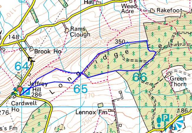
BEACON FELL WITH THE BOWLAND HILLS BEHIND.

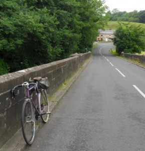
After my last post about rain the summer-like weather has been around for a few days and I was tempted out bouldering one afternoon which left me with an extremely sore left big toe. So back on my cycle for a few short rides but I felt the need to get into the hills. Was tied up most of Saturday until tea time, but then a quickly packed sac with basic bivi equipment saw me strolling out of Longridge at 6pm.

I planned to follow the first stage of my Longridge Skyline Walk  and spend the night somewhere on Beacon Fell. What a beautiful, warm evening as I walked through fields with lapwings tumbling overhead. The May blossom in the hedgerow was at its best, can’t you just smell it?

Cattle were out enjoying the rich grass and were being a general inquisitive nuisance, charging about, one just has to be aware of any possible danger. The sheep and playful lambs were easier to share a field with.

Onwards through Goosnargh Golf Club, with the fairways in prime condition.

Further on the building work on the old Cross Keys Inn seems to have come to  a standstill. inside is a surreal builders’ dining table. Made me think ‘Hotel California’ somehow!

More troublesome cattle accompanied me up the fields into the woods of Beacon Fell. A few families were about in the car park, however the café was closed. I had planned to arrive at the summit for sunset, but cloud spoiled the scene.

A new owl sculpture has been installed in place of the ‘hanging bat’ and I stumbled upon  a wooden carving of a crocodile to complete my collection of Beacon Fell sculptures to date.

As dusk fell, I found myself a comfy bivi spot with views of the Bowland Fells.

Roe deer were wandering about and barked noisily for a while, obviously I was on their territory. Sitting there, I was treated to a spectacular low flight of a Barn Owl looking for prey — spellbinding. And then the bats started their rapid flypast.    Sweet dreams.  I awoke at 5am as the sun came up but managed to doze off till 6.30, so I was away to a leisurely start by 7am.

My plan was to walk down the valley of the River Brock for a few miles. Bluebells and wild garlic abounded  in the shade.

I was impressed by the depth that the small river has carved for itself over the centuries. This is Dipper and Wagtail territory. The path was in a poor state, boggy and eroded, so progress was slow. Nothing much else stirred until I came across the tents of D of E teenagers near Waddecar Scout Camp, they were just stirring!

Soon I was at Brock Bottoms where a few early dog walkers were out. This area has been tarted up with gravelled paths etc. I just remember days with my kids hopping down the river and exploring the ruins of one of the many water mills. Now the ruins seem smaller with no sign of the wheel or any millstones.

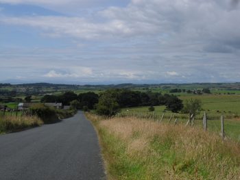
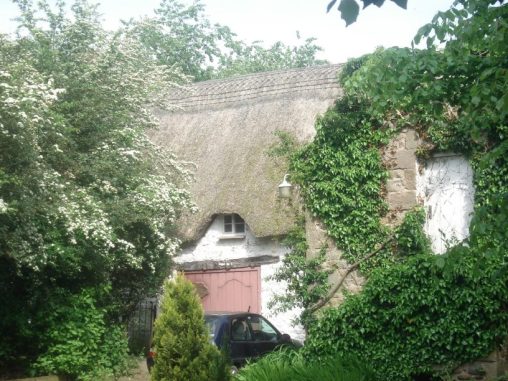
Once out of the valley at Walmsley Bridge I followed field paths to emerge at the delightful thatched, old farmhouse of Scotch Green, I do wonder about the derivation of these names, but there was nobody about to ask.

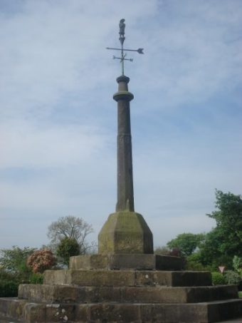
A rest stop at the village cross of Inglewhite was prolonged by a chance meeting of an old friend out walking her dog.

The  pub was closed for restoration, hopefully it will still have a bar for the locals who would keep it alive. The local chapel seemed to have a sizable congregation. On a wall was one of the old AA information plates — remember these.

Onwards down an old bridleway and ford, now bridged for safety reasons, into Goosnargh and back home for lunch! 

That’s how I recharge my batteries and connect with the land in this beautiful area.

THE HEART OF BOWLAND.


Distant Wolfhole Crags.

Another day out walking with the lads from Bolton was planned with a 9am, we enjoy a lie in these days, rendezvous just off the M6 junction. To ring the changes I had planned a round of the fells from Tarnbrook and was in sole charge of navigating and the map.

To my horror, as I drove to the motorway,  I realised the said map was still on my kitchen table — necessitating a rapid turn around and subsequently a ribbing for the delayed start. The twisting lanes leading  from the next motorway junction north seemed to go on forever, more than my memory of them. The hamlet of Tarnbrook thankfully hadn’t changed at all, though. (PS, Parking here has recently become a problem.)

We were greeted with a warm sun and clear skies, which promised well for views on the fell tops. . Most of the land around here is now open access from the CRoW act of 2000. Prior to that we were evicted several times whilst climbing on the rocks up at Thorn Crag, lying high above Tarnbrook. This is grouse shooting land previously strictly restricted. A sad observation is that the estate has now built several ugly ‘roads’ through these remote hills. The other observation is that one doesn’t see the Hen Harriers or Peregrines any more.

I came across this interesting article and debate about raptor persecution in the area….     http://raptorpolitics.org.uk/2014/01/06/politics-is-still-undermining-raptor-conservation-in-lancashires-forest-of-bowland/

Getting back to the walk we headed off in an Easterly direction on what is marked as The Wyre  Way past a few old farms and onto rougher, virtually, trackless ground leading up onto Brennand Hill. Slow progress necessitated a coffee break in a clough  on the way.

Sign of the times.

Eventually we reached the stoney outcrop marked on the map as Millers House. Here we found the odd abandoned millstone hewn from the gritstone — what a life it must have been up here chipping away.

Noticeably there were far fewer gulls in the area than before, I think culling by the NWWB has reduced the upland breeding population.

Onwards brought us to the fence on the broad ridge and a diversion for a lunch stop at Wolfhole Crag.  This must be one of the most remote bouldering venue in England, but there was some chalky evidence of recent ascents of the harder problems.   http://www.lakesbloc.com/guides/wolfhole-crag-guide.pdf

Our own clumsy ascents would be better not recorded.

The day had changed and was now dull and cold, so views to the Three Peaks and the Lakes were poor. The never ending plod westwards along the boggy ridge didn’t have much merit in these conditions. Crossing one of the aforementioned, incongruous estate ‘roads’ we came across several areas of heather reseeding and stabilisation of the peat bogs. Respite came at the first trig point on Ward’s Stone, 561m. We realised that we had been walking steadily uphill for the best part of 4 hours to reach this point! A welcome flat area led to the next trig point, 560m. The views to Morecambe Bay were sadly limited but the Wyre estuary was clear, that’s where all the water from up here goes.

An unusual benchmark.

Our planned route continuing westwards to the more interesting Grit Fell and Clougha Pike was curtailed to another day as we dropped off the fell and down the endless lane into Tarnbrook.

Descent into Tarnbrook.

12miles over this rough territory was enough for us today. We saw only two other walkers all day and that on a Bank Holiday weekend!  We will be back for Grit Fell and Clougha Pike.

OUT WITH THE BIKE.

Bike and Bowland.

Have not made much progress with my walking, go up to the shops for the paper and back in the morning, that’s about it. Not wanting to push the pain too far.  So for two months I’ve lived the proverbial couch potato and it’s not suiting my psychology. Didn’t think I would be able to pedal my bike with the post-op foot but last week out of desperation dragged my old trusty road bike out of the garage and gave it a spin around the village. Pleasantly surprised to manage with minimal discomfort, kicking myself for not trying earlier!

On the fair weather days I’ve pedalled around the flattish lanes realising how unfit my old body has become.  Today was one of the better with lovely almost warm sunshine and little wind. So in late afternoon I cycled out to Chipping and back, feeling much invigorated by the gentle exercise. Chipping is a delightful village at the foot of Parlick in the Bowland fells. It was mentioned in the Domesday book and is a fascinating place to look around. At the cobbled entrance to the old part is the building originally used as Brabins School established in 1684 and round the corner is a shop/cafe, built by the same John Brabin in 1668, said to be the oldest continuously trading shop in Britain. Two of the three pubs are still open. The Anglican Church of St Bartholomew’s presides over the village. So lots to see. Sadly the last remaining wood turning mill has closed.

Brabins School.

Another reason Chipping deserves its popularity for, especially with cyclists, is the  welcoming Cobbled Corner Café and that’s where I headed for today!

                                                                                                                                                             All is not rosy for the cyclist in these parts — motorists use the lanes as race tracks and if they don’t get you the proliferating potholes might.

  I need to readjust to two wheeled transport, somehow it doesn’t connect to the land as much as walking does for me. Still I may get fit and loose some weight.

The Preston Guild Wheel next.