Walk 37. Weets Hill from Barnoldswick.
Barlick, until local government reorganisation in 1974, was in the West Riding of Yorkshire. It then found itself in Lancashire, the locals were not happy and many still see themselves as Yorkshire folk. Back in the day, until 1992, you had to be born in Yorkshire to play cricket for the county and I seem to remember special dispensations being given to players from Gisburn/Barnoldswick area when they were in Lancashire. Or was that just a rumour at the time. I do remember well however White Rose flags flying defiantly in Gisburn as you drove through.
None of this has any relevance to today’s walk except to point out we are in the far east of the county where Lancashire mills give way to Yorkshire dales. A 10-mile day of easy navigation, gentle gradients, canal towpaths, a Trig point and lots of fields. Stick with it – there is plenty of interest.
I approached the recommended Greenber Field car park down the narrowest of lanes, I was almost giving up when it suddenly appeared hidden in the trees. On my return I took a wider road, the B6252, back into Barnoldswick and I would recommend that as your approach. Unfortunately the café on site was closed due to staffing shortages, a common problem of hospitality in these strange times. That’s the second day in a row I have been deprived of my coffee. Still the day was promising with warm sunshine and blue skies.
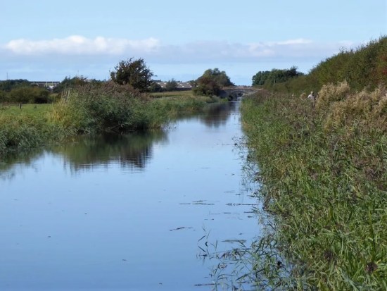
I set off with enthusiasm along the canal towpath on the edge of town. Easy strolling with lots of friendly and well-behaved dog walkers, pram pushers and cyclists. I passed three of the prominent manufacturers in town – Rolls-Royce, Silent Night beds and Esse stoves. All but one of the many cotton mills have gone. The canal was busy with boaters. On my longer canal walks I often try to pick out the most humorous, or more likely corniest, boat name of the day, Mr. Grumpy won today. All making for an enjoyable start to my day’s walk.


In fact the morning was disappearing fast – made more so by an extended chat with an enthusiastic walker. We got onto the subject of the Lake District which he seems to have just discovered. Out came his phone with pictures of Coniston, Helvellyn and Scafell etc, many in selfie mode. I had to make my excuses to get under way again.
Once I had left the canal I saw virtually no one else for the rest of the day.
My way up onto White Moor was mainly on well surfaced bridleways, that PBW again. As height was gained the views opened up, with my recent ascents of Bouldsworth and Black Hambleton prominent to the south along with the rest of the Pennine Chain, and there was little Blacko Tower. Perhaps I was distracted, but I took to the moors sooner than I should have, up a well trodden track (SD 869 441). On past a plantation obvious on the map, that’s when I realised my mistake, but the track alongside a wall was good, so I just kept going until I was within a stone’s throw of the summit. Birds eye views of Barnoldswick appeared way down below.


What did I say about easy navigation? As it happened this was possibly better than the longer way round and up the tarmacked lane to Weets House, it was easy to navigate once I knew I was lost – if you follow my logic.
The summit was adorned with a shiny white Trig Pillar and even better as I was ready for lunch a memorial bench. And what a panorama – the nearby bulk of Pendle, Longridge Fell, the Bowland Hills , Ingleborough and Pen-Y-Ghent and lots more. The Ribble Valley stretching out in front of the hills completed the scene. 


It was only after some time sat there enjoying the view that I noticed beneath my feet little plaques set into the soil, each one a memorial to a departed family member whose ashes were no doubt scattered up here. I like the idea of being scattered from one’s favourite hill, but I thought the plaques possibly out of place. No offence to any family concerned who had the wishes of their departed granted.


Time to head down, and I followed the track I should have come up to Weets House, an isolated property as you could wish for. Back on the PBW I headed north wondering who had travelled this way in the past centuries attending to their trades. Miners, pack horses, farmers, soldiers? The map depicts ‘ancient earth works’ from early times and there is a Roman Road crossing my track at one point. 


A quiet road, Brogden Lane, winds down the hillside past upland sheep farms and comes to a right angle corner at The C18th Manor House, what you see from the lane is actually the back of the house. A ford then leads to Brogden Hall. That was my way and I circled around what is a large equestrian centre with only a glimpse of the hall itself. Out into the fields I crossed a motor cross circuit – the penny dropped I have been here before. It was when I was walking the West Craven Way in 2015. 


The pastures were full of deep grass which surprisingly makes walking through it tiresome. It’s that time of the year when the dairy herds are let out for some proper food. Passed a reservoir, and I was into a field with one of the largest herds of cattle I’ve encountered. They can be frisky at this time of year and being cautious I took to a path on the other side of the wall. After my minor trespass I was back on route up a slope now with grazing sheep and their lambs. I couldn’t resist a spring lamb photo, or two. Can’t you just taste that luscious grass? 


I worked my way through the gardens of some nouveau riche house, their garden furniture was more stylish than my lounge. I’m not jealous, but it set me wondering if they were entertaining would you be offered a drink en passant. 

This was on the edge of the little hamlet of Bracewell where there had been a former hall. The church, St Michael’s, dates back to the C12th but most of the present fabric dates from the C16th, though there is a Norman style arched doorway and apparently inside a Norman font. (it was locked today) For some reason I ignored adjacent Hopwood House and Farm, both grade II listed. But my attention was drawn to the ‘Old Post Office’ with its inscribed plaque, but why on earth did someone build a porch whose tiles obscure that plaque. 


I have a gripe with Mark for the next part of his route down the busy and twisty B6251 road. This is dangerous considering the speed of traffic along it. Driving back along that stretch on my return I was behind an articulated lorry doing well over the permitted 40mph, no chance of that stopping quickly. Looking at the map there is a footpath leaving Bracewell to the abandoned village of Stock where there may be earthworks to see. A public footpath from there crossing Stock Beck would bring one back onto the bridleway route. I wish I had taken that way, which as well as avoiding the dangerous road looks to be of interest in itself. I would recommend you do.
I didn’t, and I had to brave the oncoming traffic for half a mile until I could escape onto a peaceful bridleway. If you look closely at the contours of the countryside here you will see lots of small hillocks. These are drumlins, glacial deposits of boulder clay on the surface limestone. Today with the abundant Spring greenery they took on a magical landscape over which I expected troops of elves to come skipping along. It was however a good place to watch lapwings in their rapid flight. 

The walk ended through Greenber Field Farm. All very neat and tidy but far removed from the farming as I knew it. Massive sheds, computerised cows and not a farmer in sight’. The C18th house itself is Grade II listed.


Well not quite the end as I spent some time watching canal barges come through the lock gates, the summit of the Leeds -Liverpool Canal. 


***


 As I approached the west end of Morecambe I was intrigued by a large building set back from the front. The building now known as The Battery once marked the boundary between Morecambe and Heysham. (in 1928 the two districts merged). In the nineteenth century the site was occupied by an old mill and the area was later used as a firing range, with an artillery battery stationed there because of fear of an invasion by the French. The mill, then known as The Roundhouse, was used for storing ammunition. The Battery Inn was built in 1863 and in 1900 it expanded to become The Battery Hotel, later acquired by Thwaites Brewery and functioned into the 1980s. It has recently been bought by a property developer for conversion into luxury flats. I’m not sure whether much progress has been made.

 And what’s more on the other side of the road a series of artistic panels brightening up an otherwise drab development hoarding at the former Frontier Land. I now remember Eunice from the Mouse House mentioning them


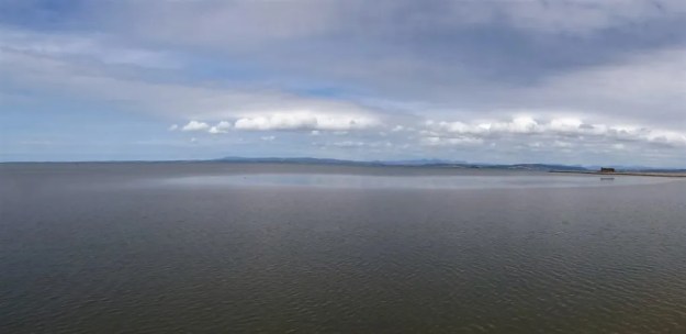
 Following on from the conversation I had a couple of days ago with that gent up at Otter Geer I eventually dragged myself out of bed, breakfasted, loaded the bike and drove to my usual spot at Halton station on the Lune. Make the most of each day was my intention even though it was by now afternoon. A quick whizz along the canal and I was on the bay. The tide is out, and I can hear but can’t see the birdlife out on the edge. This vast expanse of marine environment has been highlighted by the Lancs Wildlife Trust as being under threat if important EU regulations are disbanded by our reckless government. In fact my visit here prompted me to post their letter


 I can’t believe it but on a cold winter’s morning I get mixed up again with a half-marathon run along the cycleway from Halton into Lancaster. Back in the summer I was in the mixt of a larger run, and it proved frustrating on the narrow paths.
 So today I took an early opportunity to seek escape up the ramp onto the Lancaster Canal Aqueduct, over the Lune and into quiet countryside. Only the odd dog walkers were met before I disembarked onto the promenade leading around the Bay to Morecambe.


 I was now wheeling by cycle along the pavements. The old station with its impressive frontage was next. Peeping inside there was a rather lacklustre Xmas fayre in progress. The room was presumably the old spacious waiting hall, in its heyday this station would have been extremely busy bringing tourists to the heart of Morecambe. ‘Bradford-by-the-Sea’. The new station is a bleak platform in an industrial waste – so much for thoughtful planning.


 I
I


 At the next farm I weave through a complicated series of gates in their garden. Enquiring of a lady, to confirm my way, that few people walk through here – she says “most get lost”. I doubt the irony strikes her. Again a few yellow arrows wouldn’t go amiss. At last, I’m free and walk down a lane to another farm, Whitemoor Bottom. The guide says take the footpath on the right, but there is no obvious way – I strike boldly through the farmyard and onwards down the fields. This is horsey country and barriers keep appearing, is it this side of the wires or the other? Determination sees me through, and I drop into a wooded gully with little sign of others coming this way. But I’m on course and eventually come out onto a lane at Holly Bush Farm. Sand Hall, which looks as though it should be listed, is passed, and the lane takes me to Foulridge Reservoir.


 I’ve cycled this route several times in the last few years but there seemed to be a lot more happening today.