 Sat alone on the isolated true summit of Fairsnape, deep in Bowland, I’m poking at one of my sandwiches, egg and tomato, made a month ago. They went into the freezer when hot weather and circumstances cancelled an outing at the last minute only for them to re-emerge this morning. there is a distinct unappetising taste. Should you freeze hard-boiled eggs? I’ve just traversed some of the loneliest hills up here and am in need of some sustenance. The morning has been misty on the fells, however with a welcome cooling breeze. Distant views are restricted from my lofty perch, most of you will never have been here. Only a few curlew and grouse share my space. I poke again at the sandwich and decide to toss it into the heather for probably the seagulls, who now also patrol these heights, to scavenge.
As I say the day started off murky and cool with low cloud, quite the opposite of the mini heat wave we have been enduring. Ideal for a tramp across these Bowland hills. For a start don’t take Mark’s advice to leave your car in the Delph Lane car park, it’s none too safe and leaves you with quite an uphill walk before you start. There are suitable lay-byes nearer Stang Yule. Walk number 2 in the Cicerone’s Walking in Lancashire book.
The way starts at a gate leading onto open access land. Welcome. On closer examination a notice says ‘No open access – temporarily closed at the land manager’s discretion’ Not a good start at all. But wait, the date is 2021. This sign has not been removed or updated for two years. So much for the land manager.


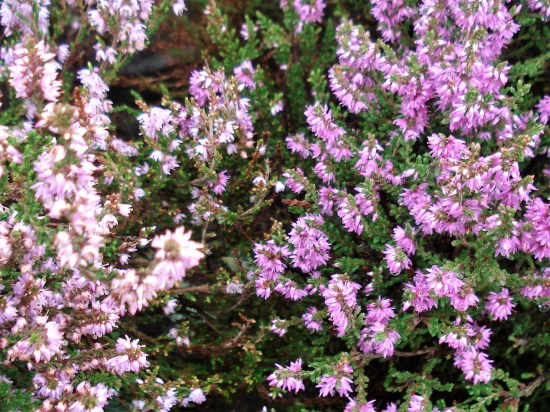
I try not to read too much into this as I stride boldly onto the access land. Nobody will see me in the mist. I’m enjoying the heather under foot, there is a path of sorts but not many come this way, put off by that notice possibly. Slowly I gain height and pull away from the plantation onto the open fell side, A track takes me across the slopes of Hazelslack Fell, a rarely visited spot. The last time I was up here was with Sir Hugh and JD on our straight line adventure between our homes. It’s as remote as I remember. 

The views back to the Fylde are supposed to be good.

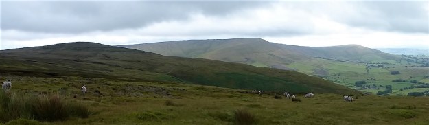
Approaching Hazelhurst Fell.

Looking back with the track skirting below the summit of Hazelhurst.
I don’t bother with the 429 m trig point this time as I’m probably going higher shortly. The track dips down and climbs the contours gradually onto Winny Bank. The raison d’être for this track becomes obvious with the appearance of shooting butts. Not only the butts but also the small mammal traps, thankfully decommissioned. The highlight of my week, if not the month, was witnessing a family of Stoats crossing a road on Longridge Fell. Distinctive with their black tipped bushy tails. Who would want to trap and kill these beautiful animals?? 


Along the way is a stark memorial to airmen lost on these hills in WWII, I have a book somewhere listing all these crashes and giving their accurate sitings. 
The track starts to descend, and I have to be alert to pick up the ongoing path to Fairsnape otherwise I would be floundering, I know not where. The path begins somewhat unlikely with a few steps leading off a turning place. The stone flags don’t go far and one is left following intermittent white posts through the morass of peat. You will be glad you came here in dry weather, preferably a draught, also not a good place to be in thick mist. Stick with it, and you will arrive at a fence corner euphemistically named Webster’s Meadow. (if you miss it you would be in ‘Dickey’s Meadow’) This is also known as Fiensdale Head, the way through from Langden to Bleasdale. A partially flagged path shows the way. it’s a long time since I’ve been down Fiendsdale, a good spot to see ring ousels. No idea who Webster was or Dicky for that matter.

Turning spot.


The way down to Fiendsdale.
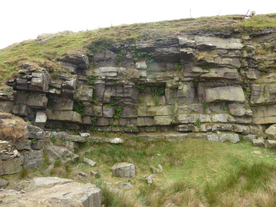
United Utilities have an information board explaining the work being carried out to try and reverse some of the peat erosion. When I was last up here they were helicoptering bags of stones in to be incorporated into ‘dams’, stopping further erosion from run off and re-wet the surrounding peat. Evidence of that work is all around with stone and fibrous matting in the peat cloughs. One does wonder how much we can do to repair the damage which must be on a vast scale in Bowland alone. Are you still able to buy peat based compost – I hope not? 


A few more flags are encountered, showing a way down to Bleasdale and ahead to Fairsnape. Then you are on your own again with the fence for company. The book talks of ‘hard going’ in the peat hags – ‘hopping over to the other side of the fence may help’ Today that is not necessary as it is as dry as it is going to get, but there are still boggy morasses you wouldn’t want to fall into, perhaps the re-wetting is working. Knees are allowed for climbing out of the deepest hags. 


Anyhow, I’m soon sat at the 520 m summit contemplating my lunch. There is another informative board up here telling the same story. Some of the funding came from the EU, pre Brexit. How much will our own DEFRA run by Thérèse Coffey put into environmental schemes? 
It’s a dry run over to the other summit of Fairsnape, the one with the shelters and trig point. I’ve not seen anybody all day so far and can’t believe I’m the sole person at this popular top. Only when I get closer to the shelter do two heads pop up – a young couple having some private time to themselves. 
The mist has lifted a little allowing the gliders from the club down below to take to the thermals, spookily and silently sliding past out of the thin cloud. 
The way off, by a cairn, is down some zigzags into Bleasdale. I have always assumed these to be part of a sledging route for bringing cut peat off the fell. Beautifully constructed and a joy to walk whichever direction, up or down. Few people used them as most are linking Fairsnape with Parlick along the ridge. But Mark knows this area well, covering Bowland in detail, the secret is out. 


What a contrast from the northern side of the fells – endless peat and heather as far as the eye can see and down here in Bleasdale with the green pastures stretching to Beacon Fell. The guide book takes you on tracks that would give access to Bleasdale Circle, but I’ve been there many times and at the moment it is a bit of a mess following storm damage to the trees, so I take a slightly different route through Bleasdale, past remote farms, past the old reformatory school buildings and past Bleasdale Tower. North Lancashire Reformatory for Boys, Bleasdale, near Garstang, Lancashire (childrenshomes.org.uk)

That little lay-by.
The little blue car was waiting for me in that lay by, as a Duke Of Edinburgh group were going through, staggering in the heat under massive rucksacks. I wonder who had the better day?
***


 It is good to meet up with Sir Hugh again. He has been out of action but keen to get going once more, I plot a fairly easy level route from Levens of about 4.5 miles, characteristically he promptly suggests extending it farther. We made the wise decision to cancel on Friday, it rained non-stop. We will take our chances today.