
Grunsagill, no I hadn’t heard of it either. This map gives a clue, only just in Lancashire.
***
I have previously come up the Skirden Beck from Bolton-by-Bowland as far as Blue Scar, but today we were heading farther up alongside its tributaries to the isolated hamlet of Grunsagill. It turned out to be quite an epic, if one can apply that word to rural Lancashire.
Mike found the walk in 25 Walks in the Ribble and Hodder Valleys by Clitheroe Ramblers. We have followed a few of their walks in recent week deep in our countryside. I notice that the publication is 20 years old now so one expects to find changes in the routes, but our experience is more that nobody is walking some of these rural paths which are becoming overgrown with poor infrastructure. What would today be like up above Bowland-by-Bowland.
Yes, it is official it has been the wettest February in recent history so we can expect mud at the very least. In fact we miss out the first water-logged field in favour of the water-logged farm lane alongside Blue Scar, with locked gates. The farm has been unoccupied for years and last time I was here I struggled to find the PROW up from Skirden Beck into and through the farmyard, only to discover there was a concessionary path bypassing the farm altogether. Forewarned we follow it today dropping us down to the beck side. Those new galvanised gates help us find the way to the footbridge and the steep climb to Ray Head Farm, 1677. The fields are merely damp. 


Barking dogs guard the farm yard but are called off as we pass through and follow more gates and newly planted hedges up towards Lodge Farm. There are hills ahead we don’t recognise and behind ever present Pendle watches our progress. So far so good. We stop to take off a few layers as the day has warmed up, the sun is shining and there is no wind. A green and pleasant land given over to sheep farming.


We are back to wooden stiles now and the guide warns of difficult route finding, we go astray in the wrong field above and unable to gain access to New Gill Beck. Backtracking is the only option and we find our own way down through no man’s land to another new gate and the little footbridge over the beck. Out of the blue we come across a waymark for The Ribble Valley Jubilee Trail. Later research suggests this would be a worthwhile week’s 65 mile walk through some of the best of the Ribble Valley. 


Strangely there is an in situ caravan relic in the next field, no idea how it got there. 

We make better progress on a pleasant stretch alongside the beck. 

And there in front of us is the imposing Beckfoot Farmhouse with its mullioned windows, dating from1686 and partly rebuilt 1876. The lower plaque in the porch says EBI AN.DO 1686. 


Stately living indeed and they are making changes to the landscape hereabouts, lots, and I mean lots, of tree planting but the footpath remains clear through their estate. There has also been a lot of work done along with the environment agencies to slow down the flow of water in the beck in times of heavy rain. A work in progress no doubt. It looks like an ideal place to reintroduce Beavers? 

A bit of rougher ground and a dodgy footbridge brought us to the road at Butterfields.  We now follow the quiet lanes for a mile or so, at the high point Pendle comes into view again. There are lots of cyclists, presumably from east Lancashire clubs, using this switchback route. A majority of the properties seem to be holiday lets, is this the only future for English farming? See below.
We drop into Grunsagill, a once stately house and a couple of farms. Chatting to the farmer he says it is too cold and wet up here for lambing now, best in April. In fact it turns out his sheep are down in lower fields at Longridge where we have come from.


A brief spell by Grunsagill Beck, another tributary of Skirden Beck, and we descend into what is basically a holiday village, Lower Gill. Farm buildings done up as self catering units and attached recreational facilities including a heated pool. 

If the day had ended here we would have been very happy with our walk.
The next three quarters of a mile however were spent sinking into the worst possible flooded fields and then even worse trying to stay afloat on what was basically a slurry lagoon. Slurry is an integral part of modern farming where animal waste together with other waste organic farm matter is converted over a period of time into fertilizer that can be reused on their lands to fertilize crops. It should be in a controlled slurry pit not dumped into farm lanes. Slurry pits are dangerous enough from the point of view of deadly gases and drowning. Out here we felt very vulnerable on the virtually impassable slurry track. God knows what damage and pollution the run off into streams is creating. It can’t all be blamed on the wet weather, this is dumped farm waste. It should be looked upon as a serious enough problem as fly tipping in the countryside and sewage disposal by the big water companies. A world away from the high end vacation focused and sanitised ‘farming’ back at Lower Gill. I wonder if it is their land and slurry?


We needed hosing down and disinfecting after the ordeal. A walk to enjoy in the summer months.
***


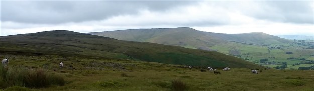
 From this elevated position the Three Yorkshire Peaks are just visible but too hazy to photograph. It is a slightly better view down the Ribble Valley towards the Parlick and Fairsnape group of Bowland. And of course you can’t get away from Pendle in these parts.
 Soon we are on the return leg, again on quiet lanes, through the hamlets of Howgill, Newby and Stopper Lane. Lots of interesting buildings are passed and we guess at their original purposes.


 Here abouts is the village institute hall, a good half mile out of the village proper. But it does have an information board which tells us, all too late, about the Heritage Trail we have almost followed.


 The temperature is hovering just above zero, but we must be under a high pressure there is no wind and the sun is shining. Perfect. I don’t carry a camera for these two days, I’m trying out my new phone.


 The quarry is hidden away just before the road starts its winding ascent. It’s late morning when I park up under the old Sykes Lead mine and the roadside Lime Kiln. The quarry faces west so should be sheltered from the easterly wind. A regular procession of motorcyclists pass me as I walk up the road to the gate.


 Sat alone on the isolated true summit of Fairsnape, deep in Bowland, I’m poking at one of my sandwiches, egg and tomato, made a month ago. They went into the freezer when hot weather and circumstances cancelled an outing at the last minute only for them to re-emerge this morning. there is a distinct unappetising taste. Should you freeze hard-boiled eggs? I’ve just traversed some of the loneliest hills up here and am in need of some sustenance. The morning has been misty on the fells, however with a welcome cooling breeze. Distant views are restricted from my lofty perch, most of you will never have been here. Only a few curlew and grouse share my space. I poke again at the sandwich and decide to toss it into the heather for probably the seagulls, who now also patrol these heights, to scavenge.


