Tag Archives: Lancashire

PRESTON GUILD WHEEL – ONE MORE TIME.

Monday.  7th December.   21 miles by bike.   Preston.

I throw the bike in the back of the car, wondering when I last rode it, and drive down to Red Scar. There is some parking just off the route of The Guild Wheel, that 21mile circuit of Preston. I’ve written about it many times but have not ridden it this year. This is what I had to say in March 2014…

In 1179, King Henry II granted Preston the right to have a Guild and awarded the town its first royal charter. The Guild was an organisation of traders, craftsmen and merchants, who had a monopoly of trade in the town.  Gatherings for renewing membership were infrequent, but from 1542 Preston Guild took place every 20 years. In 1790 there was freedom of trade in the town, which abolished the need for a Guild.  But people continued to celebrate the Guild, as its festivities had developed into prestigious social occasions, which continues to this day.

The Guild Wheel cycle route has been created as a lasting legacy of  the 2012 Preston Guild. The 21-mile route makes the most of the different landscapes that surround the city, creating a rich and varied environment for people to enjoy on foot and cycle.

After I had the greasy chain back on its awkward sprockets I choose to go around anticlockwise though there are a couple of steep hills whichever way you go. The sun is low and I’m often in the shade making it cold on my hands. Also, the staccato sunlight through gaps in the trees and hedges is disturbing to my vision and brain. New housing developments start before I have gone very far and continue along most of the Northern stretch. Where there were building sites last year suburban living has moved in. Greenfields are disappearing at an alarming rate and I don’t know how some narrow roads will cope with the increased traffic. We will look back with regret at the speed of development and minimal sensible planning just to get those few thousand more houses.

Last week I discovered the pinfold in Great Eccleston and today I stop to take photos of the one on the old A6 in Broughton which people drove past without realising it was there. So much more peaceful now with the bypass, there are some advantages to new road schemes.

My usual café in the University playing fields is closed today, query due to Covid-19 restrictions. Further on past the Ribble Link canal a new  road is being constructed coming off the M55 into north-west Preston. It looks to be a major engineering scheme not due for completion until 2024, watch this space.

The tide is out as I pass through the dockland area with lots of mud showing in the Ribble. On the edge of the docks are the Sea Cadets wooden cabins which originated as the WW2 prisoner of war camp on Moor Park, which I mentioned the other day. It becomes busier with pedestrians as I come into Miller and Avenham parks. Time for a sit down and snack on the promenade near the starting/finishing mileage post. Then it’s alongside the river to the Motorway before entering Brockholes Nature Reserve. People are wandering about with binoculars and  massive lenses but I see very little.

The last pull up that steep hill in the woods, pushing the bike, and I’m through the crematorium and back at the car. Definitely feeling stiff from the unaccustomed cycling exercise.

*****

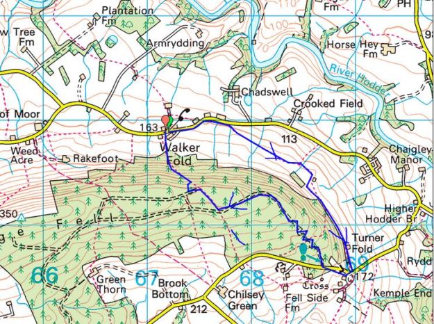
The map below needs updating soon with all the new development but the route remains basically the same.


WINTER SUN.

Sunday.   6thDecmber.  7.5 miles.   Longridge.

 I’m usually still in my dressing gown at 10am, drinking my second or third coffee. That’s how life is at the moment what with lockdowns, third tiers, grieving days and short winter days. My cleaner is still not coming to my house, in fact nobody has really been in nine months, but I can’t be bothered with the ‘hoover’ today. It’s Sunday.

I should be writing Xmas cards and words of encouragement to my distant friends but I can’t find my address book. I’m sure I had it yesterday.

It’s now 12noon and I grab a bite to eat. There is little sun but no wind or rain. I can’t face muddy fields or driving anywhere, so I opt to do my short Longridge Fell Walk on roads for some exercise. We have walked this route many times, I apologise.

I don’t meet as many people out as expected, maybe they are Xmas shopping whilst the stores are open. A few cyclists pass by, struggling on the hills, as well as puffing joggers. I just march on at a steady pace stopping now and then to take a photo, and I don’t take many of those, being so familiar with the scenery.

The Newdrop Inn is soon reached, now sadly closed for ever and then up the long drag to the high point of the walk. I think about past sunny days bouldering with friends in a couple of quarries up here, what a wonderful way to while away a few hours in utmost concentration on the rock. On a gate post is a simple arrangement, a memorial to whom?

I walk down the road alongside the golf course in contrast to the other day when we just followed the fairways. A few lost golf balls were picked out of the verge as swag. Again in contrast to before the golf car park was full now playing is allowed. Some wayside gorse brings a little colour and there is a dusting of snow on Fairsnape if you look carefully.

Once home I had another go at getting rid of the leaves on the lawn. Now where is that address book?

BEST OF A BAD JOB – MOOR PARK.

Saturday 5th December.  1.5 miles.  Preston.

How can I put this, am I anxious or annoyed?

To start with I was anxious, Chris my son had arranged [24hours previously] to come up to Longridge at 12noon for a socially distanced walk up on the Fell. He never arrived. Phoning his house brought no reply, I know when he is on ‘nights’  he switches the phone to silent in the day. More phoning was to no avail and his mobile was switched off. At one o’clock I felt I had to investigate and drove down to Preston. His car was in the street and all his curtains drawn. No answer to my knocking on his door.

How quickly can someone die from Covid-19?  Images of police breaking down that door. I already had experienced a similar traumatic episode involving the emergency services at a friend’s house in Liverpool last year. Passers-by start looking at me suspiciously especially when I start throwing objects at his bedroom window. It took several objects clattering against the glass before a weary face appeared.

Anxiety over, I suppressed annoyance; he had slept in and was very apologetic. I thought of mentioning alarm clocks but didn’t. I marched off round the corner to get some spare keys cut whilst he surfaced and drank tea.

Sorry we are not cutting keys due to the pandemic

On my return to save the day, or was it just his face, he helpfully suggested a walk around the local park – ‘whilst I was here‘  So that is how I came to walk around Moor Park and thoroughly enjoyed it.

The last time I walked through Moor Park was when I connected most of the open spaces In Preston into one continuous trail – A Preston Ten Parks Walk  [At the time I was hoping to spark the curiosity of local walkers to follow in my footsteps, although lots have viewed the post no one has admitted to completing what I thought was an excellent outing.]

Back to this afternoon we arrived into the park at its Southern gate and walked clockwise, along with many of Preston’s residents enjoying the open space and welcome sunshine. Moor Park is Preston’s largest and oldest park, originally common land it became, in 1833, the first municipal park in the emerging Northern Industrial towns. In the mid-1860s the park enclosed some 100 acres of the moorland, landscaped by Edward Milner.  It was part of a scheme to provide work for those unemployed because of the Lancashire cotton famine. A series of walks and ‘drives’ for horses and carriages were created, including an avenue of lime trees which was known for many years as ‘the Ladies Walk’. This formed the southern boundary of the park where we came in.

On the south road are large houses now used for rooms for solicitors and doctors. Also, here is the old Park School, Preston’s grammar school for girls, opened in 1906 closed in 1969. I think it is part of the campus for Preston College now.

Passing the children’s playground there was a little café open and doing a good trade in takeaway coffees.

At the edge of the park was a granite stone [?erratic] commemorating Tom Benson’s world record In 1997  of walking the perimeter of the park, covering a total of 314 miles!

The path we took ran through sunken gardens with an ornamental grotto and rocky tunnel.

The Jeremiah Horrocks Observatory was built in time for the 1927 total eclipse of the sun. [Horrocks was a 17th century astronomer from Hoole]. The university now own it but light pollution and vibration from the busy Blackpool Road prevent it being used for serious scientific research.

In the C18/19th the park was host to horse races  and there is a starting stone still present recalling those days.

The Serpentine lake is now looking rather unloved,  The supports and gates of a demolished  bridge were constructed from Longridge stone.

On this far side there used to be open air baths, they were filled in during the early seventies. There is no sign of them now.

During WW1 a hospital for the wounded was built.  After the hospital was closed in 1919 the buildings were used as an open-air school and then a prisoner of war camp in the second world war. When it closed some of the wooden buildings were moved to the docks for the Sea Cadets Headquarters. Only the interpretation board gives a clue to its position.

On the East side of the park  is the Preston North End football ground; they were a founder member of the English Football League in 1888. Today there was a league game being played, but due to Covid-19 rules no supporters are allowed so you wouldn’t know it.

That was an hour well spent with my lovely son.

*****

 Preston Council’s amateur map is reproduced below, by all means click on it to enlarge


THE FYLDE AROUND GREAT ECCLESTON.

Wednesday 2nd December.  6.5 miles.  Great Eccleston.

Great Eccleston is a village in the Fylde, that often gloomy and flat area of Lancashire not known for its walking. It was mentioned in the Domesday Book so has ancestry. It is known locally for its traditional shops, good pubs, a weekly market and its annual agricultural show which incorporates tractor pulling competitions, a niche motor sport. I parked up at noon on a sunny day, one needs the bright sun on these featureless landscapes. There was a bit of a market in the main street. I noticed one of the pubs has closed. There is an old pinfold down the street.

I left by Leckonby House, named after a wealthy local who bankrupted himself and ended up In Lancaster Prison. There was a C18th dovecote strangely isolated in the next field.

The St. Annes church at Copp was a prominent landmark up the road. It was established here in 1723 halfway between Gt. Eccleston and Elswick as a chapel of ease for St. Michaels. Nearby is a local primary school and opposite the old schoolhouse. It seems odd that the school is so isolated but I suppose it followed the church originally.

Elswick down the road is another small village on the road to Blackpool famous for its ice cream parlour. Also tucked next to the United Reformed church is an old chapel with a date stone of 1671 when this area was a centre for Nonconformity. The chapel is rather plain and has a house built onto it, it is now used as a hall for the adjacent church.

It was time to take to the boggy fields just as a hail storm blew through giving rainbows over the distant Bowland Fells.

Another stretch of lanes led towards drainage and flood defences. Here I got tangled up in barbed wire fences obstructing the right of way, later contacting the local authority they already knew of the problem. Surely the fencing contractors should be made aware of the need for stiles in the appropriate places. At last, I was on the embankment and following the Wyre downstream, a popular route for dog walkers. Walking around the loop was fast and easy which was needed as the sun was beginning to set. I had time to look at the Cartford toll bridge and the adjacent pub which has been modernised since I used to drink here 40 years ago. More rainbows appeared with the passing showers.

Being back here reminded me of a rather disastrous day walking the start of the Wyre Way.

The lights were on when I arrived back in Great Eccleston’s marketplace.

*****

THE LOWER RIVER BROCK.

Friday 27th November.  7 miles.  Inglewhite.

I have done quite a bit of walking on the River Brock recently, in fact most of it from the source to Brock Bottom. Today we walk onwards towards the Wyre a less frequented destination,  I was expecting a lot of boggy fields with awkward stiles and yes that’s what we found.

Leaving the village green of Inglewhite with its market cross we were amazed at the development spreading out into the surrounding fields. It all looked rather fine country living but where will it end. Anyhow, we splodged on to escape on to a minor road just ahead of a herd of inquisitive, threatening  bullocks.

We could relax and chat for the next mile or so until we dropped on an old way to the River Brock. There was a footbridge crossing into the Brock Bottom Mill site, I’ve written about this before. Today we walked on past the mill sites and through fields to Walmsley Bridge.

Then more fields with the River Brock cascading down hidden falls until we seemed to be in someone’s vast garden alongside the river with the no doubt grand house hidden to our left, Brock Side. It is great walking with Mike, an architect, because he seems to have been involved one way or another in the past with many of these rural redevelopments. His, no doubt up to the best standards.

After a bridge and weir the Brock has been tamed along the next stretch by concrete walls. A private road runs alongside to a dead end and a footbridge. On the left, half in someone’s garden, is the remains of a water powered mill, Matshead paper mill. Over the footbridge a lane follows the river downstream under the motorway, railway and canal to disappear without rights of way into the Wyre. No longer the bubbly Brock from Bleasdale.  There is another weir by the road and the site of the old Brock Station, closed in 1939 to passengers and 1954 to freight, now utilised as a nature reserve.


Off to join the Wyre.

Back to the footbridge we were supposed to turn into a yard and follow a path between houses and barns. All I could see was a gate into a ‘private’ garden but Mike spotted someone and asked where the footpath went and was somewhat begrudgingly told – through the gate and past the garage. I doubt few will brave this way. We emerged from a series of gates and gardens back into the fields where all was rural again with open views to the Bleasdale Fells and Beacon Fell.

These fields lead us to Bilsborrow Hall Farm, the hall itself is well hidden in woods across the way. We trusted to our directional sense to find a way through what was more of an industrial site than a farm.

The next short stretch of road was scattered with expensive looking residences, some more pleasing to the eye than others.

More awkward stiles and soggy fields led us back to Inglewhite and the Green Man, closed of course.


I have wonderful memories of Doreen playing the piano, despite her worsening Alzheimer’s, at lunchtime in August 2019.


*****

AROUND MIDDLE KNOLL.

                                                                                  MIDDLE KNOLL.

Thursday  26th November.    7.75 miles.     Dunsop Bridge.

I thought I would incorporate some  possible fish jumping into today’s walk, as I had failed on the Hodder awhile back, so I chose to walk up the waterboard road from Dunsop Bridge. First problem was the road through Whitewell was closed diverting me over via Cow Ark and backtracking  from Newton. I was still early enough to get a free parking place. The mist was just rising as I started up the valley. This is a familiar track for me but I always enjoy the view up the valley with Middle Knoll centrestage, even though today he was slow to appear… I stopped at the fish ladders on the River Dunsop just below where the Brennand and Whitendale converge. No luck, no fish, so I carried on thinking I could spend more time later in the day. You are soon into the Brennand Valley with the farm down below and views into deepest Bowland. It is awhile since I’ve been on this lower track, last time I was here with JD we did a direct ascent up Middle Knoll to satisfy my curiosity of Blue Scar, which proved disappointing.

The Brennand Valley.

Looking back into Brennand.

My route up to the col between the two valleys was as wet as usual. Views back to Brennand Fells were replaced with a bird’s eye views down to Whitendale Farm. It was a steep descent.

Looking back into Brennand.

Wet going.

Whitendale Farm.

Looking back at the steep descent into Whitendale.

This is Duchy of Lancaster land owned by the Queen and yet United Utilities [NW water] seem to manage much of the land as a water catchment area. My way back down the Dunsop valley in fact follows a pipeline taking water to Blackburn. It is a good level track overlooking the valley and I make good progress. In the past I have cycled up the water board road and hidden my bike hereabouts before taking to foot up the rough Whitendale valley, a good tip for exploring deep into Bowland. Today I rest awhile at the river intakes where concrete steps control the waters. Still no sign of fish but it is always good to see the rural postie driving by.

The pipe.

Costy Clough.

Wot? No fish.

The sun comes back out and gives lovely low lighting in the valley. I’m soon back at the car and a Covid takeaway coffee from Puddleducks Café.  It looks like I’ve missed out on the fish going upstream this year but I’ve earmarked several possibilities for next season.

Did some of those pictures remind you of Scotland?

*****


IN THE FOOTSTEPS OF ROMANS, AND OTHER CURIOSITIES.

Monday 23rd November.   5 miles.  Longridge.

There have been debates on the route of the Roman road from Ribchester to Lancaster and where it crosses Longridge Fell.  LIDAR technology has been used to reveal archaeological features. Using Lidar, experts now think it went on a slant past Longridge to Inglewhite and on to Catterall before heading due north.  http://www.romanroads.org/gazetteer/rib-catt.htm

You learn something new every day.

I wanted to have a look at the section coming up to Longridge, Mike was happy to join me on this simple exploration which should give us a ‘good’ short walk.

We started off at the top of Longridge above the reservoirs, walked through one of the old stone quarries and down a lane, which would have rattled with clogs in the C19th, The new housing estate on the right has probably been built on the line of the Roman road. Along here next to the reservoirs is The Corporation Arms, said to be the only pub owned by a council waterboard. Fortunately there is a pavement alongside the busy road until we could turn off and head towards a farm called Stonelands, probably parallel with the Roman Road. In a field is the Roman milestone pinpointed by  the grid ref. SD 62307/37134   [red dot on my map below spot height 111].  Its setting is not ideal next to a children’s play structure and alongside more modern carved stone gateposts. These have an inscription of PG 07, query sculptor and date?

The milestone itself is thought to have been inverted at some time, the squarish top would be more normal as a base. Apparently there was an inscription dedicated to Emperor Maximian c. 300 AD, but we could make nothing out. PS. I have just found in an online journal, Britannia,  a picture of the milestone before it was ‘replanted’, it had been found used as a gate post.

Our onward public footpath follows the line of the Roman road as far as Pinfold and in the next field the line of the agger was clearly seen although  it doesn’t show up well in my photos looking towards Ribchester. The field between The Corporation Arms and Stonelands is supposed to also show the agger well but I couldn’t make it out, though it does seem to show up on satellite images.

The agger was the raised ground dug as a base for the road, usually ‘scoop’ ditches are then apparent on either side. It is these changes in ground level that are picked up by the LIDAR surveys. On we marched.

Our next objective was Buckley Hall, Mike had worked on the adjacent farm buildings 39 years ago creating an upmarket dwelling. The hall itself is C17th but has been rebuilt over the years. The date stone originally stated 1662, belonging to the Shireburn family.

Buckley Hall Farm.

Buckley Hall.

Our next objective was Dilworth Bottoms which we used to visit regularly when friends lived there. This area is delightful Lancashire countryside with undulating fields and deep gills, the site of many mills in the past. Our proposed way seemed to be blocked at a pair of footbridges, we didn’t descend to investigate but followed another path to the immaculate Cage Mill. Following Cowley Brook we came into Dilworth Bottoms. There is a cluster of houses down here linked by fords across the stream. At one time there were several mills, cotton and bobbin, associated weaving cottages and a Smithy, all dependent on the running water. The mills have gone but the other properties have been renovated for modern living. The next stretch of path was a disaster, it looked bad going down over a ditch and then climbing what turned out to be the skipping out pile from stables above. I’ve marked it on my map with a red cross, skull and crossbones would have been better. Nobody had been this way for  years but fortunately the owner we met at the top was of good humour and showed us a way out of his property passing a green looking outside pool. There were horses and ponies everywhere. All a bit surreal. I hardly have the enthusiasm to report this Public Right Of Way obstruction to the authorities but perhaps I should.

On we marched.

Up the lane was another blast from the past. I’ve written about the Written Stone several times before. https://cryofthesedge.wordpress.com/2011/06/21/the-written-stone-of-dilworth/

The bridleway brought us back up into the village by the caravan park and our last encounter of the day. A man was reconstructing a stone wall damaged by moles undermining it. We got talking about all things local until he launched into sermon of the Methodist Faith  with some dodgy references to race and sexuality.  On we marched.

Preston in the distance.

*****

GOING HIGH[ish] – FAIRSNAPE.

Sunday  22nd November.  7.5miles.   Fairsnape, Chipping.

A chance comment from Sir Hugh last week – “glad to see you going high, or highish” when I hadn’t really, up above the Hodder. Time to put things right with the highest fell close to me in Bowland, at 520 m, Fairsnape.  [Pendle Hill I climbed a few weeks ago is 557 m, Sir Hugh must have missed that one, but is now out of my self-imposed lockdown driving limit]

I pull in at a little parking spot on that lonely road heading into the hills above Chipping. This  used to my fell running circuit, up Saddle Side over to Fairsnape and down over Parlick. I decide today to do it in the opposite direction, something new. I play with my camera in panorama mode trying to catch the scene, the result is the header photo.

Walking down the lane I drop into Wolfen Mill, now a group of holiday lets. The Chipping Brook which powered the mill here continues down past several abandoned watermills above Chipping.

Chipping Brook.

Wolfen Mill pond.

As I follow the estate road a rainbow develops over the fells, more fiddling with my camera.

Wolfen Hall, now bypassed by the right of way, was once the old Manor House dating back from C13th. In those days it was said to be a lookout post for marauding wolves! It has been comprehensively rebuilt and the adjacent kennels are a noisy reminder of its present hunting credentials.

I reach Fell Foot and meet the crowds coming up the lane, I estimate well over 60 cars parked down there. Typical lockdown weekend.

As the majority stagger straight up and down the front face of Parlick I take the contouring path round the side but do make the effort to complete the climb to the summit. Everyone is enjoying the day, even the children, and glad to chat.

Around the rim I pace myself along the well-used track. There is nobody sat on Nick’s Chair today, most don’t even notice it.

As I arrive at the 510 m summit I’m trying to get a photo of the scene when along the ridge come three friends. We compare our routes and then pass on, they down with the crowds and I across the peat hags to reach the true summit.

Paddy’s Pole, shelter and trig point.

Visibility is good for this dodgy stretch where you can flounder into serious bog if not careful. I was the only one at the cairn but a man appeared from the delights of Fiensdale looking rather bedraggled.

The true 520 m summit.

On I went using the decent track eastwards and bump straight into Pete, a photographer friend who is compiling a new book on Bowland. He is laden down with long lensed expensive cameras and hasn’t come far. More catching up in these strange days when you don’t see your friends for months.

There are some well-used tracks down Saddle Fell, probably old sledge ways for gathering peat. I stray to look across at Burnslack Fell and down to the remote Burnslack ‘farmsteads’, this gives me the idea to extend my walk around the fell to visit this isolated spot.

Burnslack Fell.

Burnslack farms.

Burnslack Valley.

Burnslack Farm.

Pendle Hill and Longridge Fell.

As I wander back up the lane to my car hail showers blow in – winter’s coming.

*****

THE INFANT HODDER.

Thursday 19th November.  5 miles.    Cross of Greet Bridge.

I remember walking The Hodder Way 15 years ago to check the route description for an upcoming guide. We started on the watershed high on that lonely road from Slaidburn to Bentham. Next to the road is the base of the medieval Cross of Greet.  A large irregular block of sandstone with a flat top having a rectangular socket, once marking the boundary between Lancashire and Yorkshire. This road is a favourite with cyclists continuing over Tatham Fell and perhaps making the return over Clapham Common and Bowland Knotts. This morning the whole area looked appealing in the sunshine.

From up here the Hodder starts its journey and snakes down the valley.

Back at the Cross of Greet Bridge I parked up, the Hodder is already in full flow.  The bridge is strictly utilitarian. The path alongside the river was underwater, so I headed for higher ground. Rough going was to be expected, and the side streams became more and more difficult to cross. I had nagging doubts about whether it was wise to set off when there was so much water about. Everywhere was awash. I was pleased to arrive at the ford over Kearsden Beck dry footed, thanks to my new boots, but the water here was too deep and fast flowing, so I scouted upstream for another crossing finding one without too much difficulty and hopped across.

Spot the barn.

Unfordable ford.

A hop across.

Now back on dry land I was climbing uphill above Catlow farm to a solitary barn on the skyline, seen in one of the photos above.

Remote Catlow Farm.

Sinkhole marked on the map.

That barn.

Old cart.

Pendle portrait.

Bowland Knotts were beyond if I’d fancied an even rougher pathless walk, but I decided to traverse the hillside towards New House barn with Stocks Reservoir and Pendle ahead. I was now on the upper half of the Stocks Reservoir walk which I knew well. Up here above the Hodder I can see across the valley to Lamb Hill where I’m heading. Steeply down to the footbridge over the Hodder where I remember stepping stones, they would have been underwater today. The ruined farm of Collyholme is barely recognisable.

New House Barn.

Lamb Hill across the valley.

Collyholme.

The steep pull-up to the road has been paved in places which was a help in these boggy conditions. I could have just walked back along the road, but there is a footpath marked going up to Lamb Hill farm which I followed.  The farm has massive modern barns making the house virtually invisible.

Lamb Hill Farm.

Across the valley Bowland Knotts filled the scene. A footpath of sorts weaved through and on down the sodden fields. I came out onto the road just above the bridge but wanted to investigate some riverside sheep pens I’d noticed earlier. Climbing over a fence and going through dead bracken gave me a bird’s eye view of the extensive walled folds. These must have been used in the past when bringing the sheep off the fells and sorting them, I doubt they are in present use. The world has moved on even up here.

The road over the fells.

A short day but what a beautiful remote area.

*****

PONIES ON THE FELL.

Tuesday.  November 17th.  5 miles.  Longridge Fell.

What a gift for my ‘a new experience every walk during this lockdown’. Fell ponies welcomed Rod and I to the summit of Longridge Fell. I’ve never seen them up there before and I have no idea where they come from. Three healthy looking, sleek, black ponies. They were used to human presence and searched our pockets for food. It is not a good idea to feed ponies as I believe  they can become ill quickly.

We had arranged to meet on the fell road as we hadn’t seen each other for 6months. A little inventiveness had to be used to get parked amongst all the other lockdown ramblers. I warned Rod in advance to wear boots as everywhere off track is decidedly gloopy. Certainly on the last quarter of a mile from where we had left the forest road it was difficult to stay on solid ground.

The sun shone a little into the Vale of Chipping below us and the Bowland Hills looked – well just like they always look, majestic, if a little hazy. I steered a way through the woods along the ridge avoiding the worst of the mud and the fallen trees. We then made our way back on the solid ground of the main track and caught up with each other’s news, restricted as it is. Home in time for a late lunch before it rained. See you after Christmas Rod? Strange times.

*****

A HISTORY LESSON IN WYRESDALE.

National Library of Scotland.

Monday,   November 16th.    9miles.       Scorton/Dolphinholme.

The river Wyre takes a sinuous route between Scorton and Dolphinholme and you can see from the map many fishing lakes along the way. Years ago it would have been a different scene with leats, millraces, serving the numerous mills in the valley. My ‘guides’ for today live in the area and know an awful lot of relevant history. The last walk with Peter and Denise was a couple of winters ago when we followed and traced the Lancaster Canal from Preston to Kendal.

After driving 14 miles, within my 15mile limit, I meet up as the one other socially distanced person. We are all following the rules now, even Boris has to. Off we go along lanes close to the motorway passing the farm of a close friend, sadly departed 5 years ago, where my family of cats originated from. It is eerily deserted today.

My cats’ homeland.

We pick up the Wyre Way which seems to have changed since I walked it a few years ago. The footbridge over the motorway has been dismantled, apparently the path goes under now. The caravan site we walk through has expanded dramatically but of course nobody is allowed to stay at present. The big attraction is  the fishing lakes established from old gravel pits, stocked with carp, pike, bream, tench, roach and perch. They don’t have a sympathetic feel for a path. A better stretch alongside the Wyre brought us to a bridge that used to lead to Wyreside Hall. Further along is the old Coreless water mill with its restored wheel.

We come out into Lower Dolphinholme. Peter points out the old mill warehouse, now apartments. The road down to the bridge used to come to a ford and when it was built up the doors to the cottages became smaller and smaller. The mill manager’s and mill owner’s houses are prominent and there is a redundant gaslight on the corner. The large mill here was originally for worsted manufacture and was one of the first mills to have its own gas works to light the mill and village.  Apparently behind the private walls is evidence of the gas containers. Peter knew all about this but for you a good history is really worth consulting – https://historicengland.org.uk/listing/the-list/list-entry/1466557


Diminishing doors.

Mill owner’s House.


As we leave the village I’m taken on a slight detour to visit the flue and chimney up the hill. It was built as a dual structure one for the gas and one for the steam from the updated mill.

We were going up  Waggoners Lane an obvious reference to the mill’s transport and then into Tinkers Lane, another reference to the past. This led past Belvidere House with its unusual hexagonal attached tower. Up here we were on the edge of the Bowland Hills and sheep were the only animals in the fields, subsistence farming. We came to a crossroads at Street where the Roman Road from Ribchester to Galgate was supposed to have run.

Now back onto paths alongside becks and fishing lakes. We saw a roe deer pirouette across a stream and vanish into the woods. It was muddy going. We skirted the grounds of Wyreside Hall, a large C18 pile which seems to be undergoing renovations/extensions – maybe a hotel or wedding venue? The local couple we met leading a thoroughbred racing horse didn’t know what was afoot.

The grounds of a farm and barn complex felt unwelcoming – high walls and vicious barking dogs. Coming out onto a road we parted company with Denise who took the direct route home to hopefully put the kettle on., I wanted to go through the grounds of Wyresdale Park which I had noted on my recent visit to Nicky Nook and Peter was all too ready to give me some more history. The hall was the work of  Lancaster architect Paley in the mid C19, better known for his churches, in a Gothic Revival design and over the years has been adapted to its present state as a recreational facility. Cafés, craft centres, camping pods, weddings, playgrounds and fishing are all on offer or at least they normally would be. I couldn’t see the hall but know where to drive through in future for a peep.

Wyresdale Park’s photo.

We strolled through Scorton with its iconic motorway spire. There once was a large cotton mill here, and we could see the line of the millrace now in a modern development. It was easier to walk along the road for a while rather than the soggy fields. I was then shown the lodges for the mill at Cleveley Bridge. We then followed the line of another mill race coming from the Wyre some distance away. Apparently in the early years of the C20 there used to be a series of commercial fisheries along here with water siphoned off the mill race. I had no idea where I was but soon we were climbing up to Shireshead, past the little chapel, now a recording studio, and along the lane for that cup of tea.


*****

FAMILY DURING LOCKDOWN.

Friday.  November 13th.  5.5 miles.  Bleasdale.

Just spotted it, this is Friday the 13th, survived again.

As you may know I’m trying to get something new from each of my lockdown walks. When I say ‘new’ I’m encompassing new perspectives, new experiences and hopefully new encounters with nature or whatever.

I haven’t seen Chris, one of my sons, for about three months so that is something new for today. He is a baker and social distancing is not the best but his firm have had no cases, yet. There is talk amongst some of his workmates with friends who have tested positive but nobody has volunteered to self Isolate. I imagine that is quite a problem generally with people not wanting to lose their wages.  As he works night shifts there are not many afternoons when he is up, but today we arrange to meet in Bleasdale, a short distance drive for us both, well within the ‘rules’.

Social distancing is the order of the day. Since the last time I saw him he has grown a beard, fortunately I knew of that from telephone conversations otherwise it would have been a shock. Strangely half the hair growth is white, so he has gone grey without knowing it. We do the usual walk except the muddy bits. He thinks it is 20 years since he was last up here.

Here are a few photos from our walk.

The postman cometh.

The school master’s house now a desirable country residence.

One of those abhorrent vermin traps but open to any creature. Should be made illegal.

Is this Rhododendron flowering late or early?

Ever the gentleman.


Beacon Fell and a hazy Preston.

Pointing to Parlick

That wonderful beech hedge.

The River Brock on its way.


The afternoon is pleasantly sunny, and we enjoy the catch up. Not sure when we will do it again.

My other son and family are in Manchester and have decided they will keep well clear of me for the time being which I appreciate.

*****

ANOTHER SIDE TO STOCKS.

Thursday 12th November.  6.5 miles.  Slaidburn.

My vitamin D is topped up as I’ve been in sunshine most of the day, a bonus for November and I made sure I got away a little earlier so that I would finish before dark. During the current lockdown I have imposed upon myself a maximum distance of 15 miles [30 minutes] car travel for the purpose of subsequent exercise, I hope that is reasonable particularly into the sparsely populated countryside north and east of me. Today I travelled a shade over 13 miles to Slaidburn. I had been expecting to park outside the village because it has been so popular recently but on arrival the car park was virtually empty. I’d joined some of those red dashed lines on the map to give a circuit to the east of Stocks Reservoir I hadn’t walked before.

Yesterday was Armistice Day and the memorial was appropriately decorated.

From the old bridge over Croasdale Brook I headed out towards Hammerton Hall.

An incident happened here many years ago but is still fresh in my memory. Alan and I were returning from a circuit of Stocks Reservoir and chatting away, arrived at the ford leading straight to a farm in the village. Without consulting the map we just waded through maybe a foot of water knowing we had dry gear in the car. The farmer was leaning on his gate watching us but said nothing until we were well through. A voice then boomed out “you can’t come this way, it’s not the path. It’s on the other side”  Sure enough we should have stayed on the far bank down to the bridge. He showed no compassion so back we trudged through the river certain we could hear faint chuckling.

Over an even older and graceful Holmehead Bridge, past the falls on Barn Gill.

And there was Hammerton Hall on a prominent position above the River Hodder.  It is a large three-gabled Elizabeth house [1600] standing on the site of a 12th century house and incorporating parts of it. Its south facade gives a fine display of mullioned windows. Once the home of the  Hamerton family, a wealthy medieval family who are reputed to have been able to ride from Slaidburn to York (approx. 50 miles) on their own land!
Unfortunately, they lost most of their wealth and power when Sir Stephen de Hamerton joined Abbot Paslew of Whalley in the Pilgrimage of Grace of 1536. This was a protest against Henry VIII’s proposed dissolution of the monasteries. Sir Stephen was executed for treason in 1537.

My arrival at the next farm, Black House, coincided with a window cleaner, for some reason I found it incongruous that he would be out in such a remote spot. We exchanged pleasantries, he was from Colne and had a large rural area to cover. Farmers down country lanes are vulnerable to theft, and he has taken years to build up their confidence. He went on to talk about churches that he works on, for free, again I never really considered the cleaning of all that stained-glass. I walked on whistling George Formby’s favourite – ‘When I’m cleaning windows’

Along the elevated farm lane I had good views of Stocks Reservoir and Bowland Knotts behind although this wasn’t the purpose of the day.

At the end of the farm lane I came out onto tarmac opposite the small Dalehead Chapel. When the reservoir was constructed back in the 30s Stocks-in-Bowland village was engulfed, On the lake bed are remains of cottages, shops, an inn and a school but the church of St. James was dismantled and rebuilt here above the waters on the edge of Gisburn Forest. I sat on the church steps enjoying the sun.

It was easy to walk past my turn off into the forest, so I had to double back along the road to find it. I plunged into the woods for a short distance but then followed a farm track past a barn down to another isolated farm Brook House Green. The usual collection of huts and rubbish surrounded an interesting house with a date stone of 1761.


I always meant to put the engine back in…

I’ll gloss over the next half mile of pathless, reedy and boggy ground to arrive at Higher Stony Bank, another 17th century house. Along the road a man was exercising his large Irish Wolfhound on his own rough plantation. He, not the dog, was eager to chat about how he had bought the land and was planting it up with wild flowers and trees. “Best view in Bowland“…

Asking where I was from and where I was going he also said he had bought Pikefield Plantation, my next destination. This is a  group of trees on a prominent hill in the heart of this countryside. His parents ashes were up there and as his mother had been an archaeologist he had constructed a tumulus. What will future historians make of that? I often do wonder about people who leave litter in the countryside but this had me baffled…

The way back to Slaidburn was complicated through small fields with awkward stiles and poor waymarking. I battled on. Slaidburn remained hidden in the folds of the hills until the last moments.

How much can you get from a 6-mile walk?

*****

RADHOLME and BROWSHOLME.

Tuesday,  10th November.   6.5 miles.  Browsholme.

My road to Whitewell was closed, so I hurriedly chose another route. I was on the way to complete another interesting looking walk from my bumper book of Bowland Walks by Jack Keighley. I found a different parking spot on the circuit which also meant I avoided some unnecessary climbing in and out of Whitewell. There was no reason to include Whitewell as I’m already well acquainted with it. It was nearly 12noon when I set off across the fields where there are some limestone craglets  and an old limekiln. When my children were small we used to come here for a scramble about. The views of the Bowland hills are not so good today.

The first farm was Radholme Laund. I got chatting to the farmer in the yard, and he told me that at one time Matthew Brown breweries leased it and spread their brewing wastes on the land. Matthew Brown started in Preston in 1830 and moved to Blackburn in 1927. In 1984, they acquired Theakston but were eventually bought out in 1991 by Scottish and Newcastle. I well remember their Lyon Ales and many local pubs were tied to them. Radholme goes back to the Domesday Book and was originally a hunting lodge, Laund usually denotes a deer park.  A large area of Bowland was set aside for deer hunting until farming took over in the C16-17th. The present house was built in the C19th and has an impressive southern facade.

Boggy fields took me down past woods which had lost most of their leaves. Longridge Fell was always in the background. The cattle are now all in their winter quarters [the best place for them did I hear you say?] at Higher Lees Farm.  Then I was in and out of a stream before coming out onto the familiar road at Middle Lees. I crossed the course of the Roman Road and followed the farm lane to the cluster of houses at Lees House. I already knew the awkward path going steeply down to a hidden footbridge over Mill Brook and then steeply up the rough ground on the other side where I disturbed pheasants galore. Sheep pastures were climbed to the barking dogs of Micklehurst. I met the farmer who talked of  Covid-19 and the fate of local pubs. Most of these hill farmers must live an isolated life and yet are happy, nay keen to engage in topical conversations  I missed the path further on and ended up with more road walking than necessary. Until now the day had been bright but I seemed to enter low mist and drizzle and yet behind me Longridge Fell and the Ribble valley were in brightness.

I entered the drive of Browsholme Hall by its elaborate gatehouse but saw nothing of the Jacobean house still occupied by the Parker family who were the ancestral owners since 1507. Most of the land I’ve been walking on today at one time was part of their estate.  I’ve added a photo of the hall courtesy of visitlancashire.com As I made my way went up the fields Pendle came into view, I was heading towards the prominent Browsholme Spire. It is said that its castellated folly was built as a landmark for shooters on the nearby rough fells. It has been adorned with satellite communication dishes in recent years no doubt earning rent from telephone companies. A case of selling one’s soul. On a good day up here the Yorkshire fells are seen but today it was just the rather murky local Bowland Hills. At the bottom of the hill in the trees a sulphur spa is marked on the map, so I searched it out but was disappointed  to find only a boggy spring with the water only faintly tasting of sulphur.

Crossing over that Roman Road once more I took the lane to Crimpton with its seven hand loom upper windows. After the reformation a wooden image of Our Lady Of White Well was brought to the isolated Crimpton for safety. Hence, the farm was well known to Roman Catholics as ‘Our Lady Of The Fells’. I found a seat for a snack looking out over Birkett Fell with Mellor Knoll and the Bowland Hills behind. I knew the next stretch through the forest was muddy and awkward but I couldn’t believe my eyes, most of the trees had been cut down and a machine was clearing up. The operator was able to grab a tree trunk in the machine’s claws, whizz it through stripping the branches and then cut it to length and place in a pile. Unbelievable – lift, strip, chop all in one go.

The day was getting on with all these distractions and I wanted to search out some caves in the limestone on the way back to my car. First was Hell Hole in a fenced off copse. There seemed to be two dangerous open deep shafts and a low cave entrance all connected to the same stream system.

Further on over more barbed wire was Whitewell Cave at the base of a rocky outcrop, a small stream disappeared underground leaving a dry cave entrance that would worth a crawl with a torch. There is another pothole down the road but that will have to wait for some other time.

By now it was almost dark, there was no sunset just a little light out to the coast, but I had only a short distance to go up the road.

Another shortish walk with plenty of new interest for me. I’ve just realised I never saw another walker – a perfect lockdown walk.


*****

THE CHAIGLEY SIDE OF LONGRIDGE FELL.

Saturday 7th November.   3.5miles.    Chaigley.

I’ve just returned from a short but worthwhile walk over Longridge Fell on some paths I don’t ever remember using before.

Walker Fold consists of maybe six houses but has won Lancashire Best Hamlet accolade in the past. I park up next to the village seat. I’m late today, faffing in the morning and then calling in at Craig Y Longridge on the way up the fell and chatting to an old climbing friend. There were too many people climbing today with no social distancing, so I continued on my way.


Craig Y Longridge.

Walker Fold.

I wasn’t sure whether this was their winter log pile or part of the construction of the porch…

It is misty and the sun has disappeared for the day. My path is not signed from the road but there is a stile as there are in the next few field boundaries. There is no evidence of recent use but I get through, just. The heavily forested slope of Longridge Fell are up on my right. There is well-marked diversion navigating me around Chaigley Hall Farm, in ruins the last time I passed, if only other landowners would do the same. I now join a line of stunted trees and a sunken track which has the feel of antiquity linking to the next farm. I pass a seat I used on a hot day back in August, today’s view of Pendle is totally different.

Well waymarked!

Chaigley Hall Farm.

Coming out at Kemple End I meet the crowds, cars parked everywhere and a steady stream of folk using the forest tracks. At times there are more dogs than people, what a contrast to the quiet fields on the Chaigley side.  Another old climbing friend approaches me coming down the track. We catch up on news, I’m sorry to hear that he badly injured himself mountain biking in Gisburn Forest a couple of years ago and now is unable to climb or walk long distances. A sobering thought as bikers swoosh past. Some tracks they have created are death defying and I encounter one later on my steep descent of the fell.

I leave the main track and creep through the trees to that well known viewpoint overlooking the Chipping valley with the background of the Bowland Hills. It is all rather hazy today but I can pick out Walker Fold and my car way down below. The footpath is steep and slippy but nothing compared to the near vertical mountain biking courses alongside.

My steep way.

Mountain bikers’ direct way.

I spot a vivid toadstool growing in the farm at the bottom.

Driving home I hear the welcome news on the radio that Trump has been defeated, although he may mount legal challenges. I’m keeping my fingers crossed that the USA will come out of its last divisive four years and move forward as a respected nation.

*****

TO CATCH A SALMON.

Friday November 6th.  5 miles.  Hodder and Ribble.

A chance conversation with JD reminded me that at this time of year the salmon are heading up river to spawn. Every year I promise myself to witness this wonder of nature and each year I forget and miss the spectacle. So today I set off to try and see what is happening on the River Hodder. We are going to be walking locally for the foreseeable future and I’m going to try and find somewhere or something new for each walk I do. Today was salmon.

I walked along the road to Hodder Place, originally a preparatory school for Stonyhurst but now accommodation flats in a great situation.

I dropped to the bathing places used by the college in the distant past. This is a delightful stretch of the Hodder with several natural rocky weirs and pools. I sat at one for half an hour without seeing a fish. I was becoming hypnotised watching the water flowing over the rocks.

Moving on I walked downstream to the water measuring weir, but again no luck.

I continued down to Lower Hodder bridge next to Cromwell’s Bridge, yet another picture.

There is no way along the river here  so you are forced up the road but looking back is a wonderful vista of the river and bridges.

Then it is into soggy fields to walk through Winkley Hall grounds to meet up with the next stretch of river just before it joins the Ribble. There is an ancient tree, The Winkley Oak, along here which I always stop and stare at, yet another picture.

I  knew of a fisherman’s hut and bench where I rested for a while now looking over the Hodder joining the Ribble.

The Hodder joins the Ribble.

There was a steady stream of people walking ‘The Tolkien Trail’ and coming towards me a lone jogger who turned out to be an old friend, Nige, I hadn’t seen for a while. We had a good half hour’s chat. He is a fit guy but told me of him catching the Covid-19 virus a few weeks ago and thinking he was going to die. A cautionary tale for those doubters.

Off he goes.

Next the River Calder slides in to join the Ribble opposite Hacking Hall. I came down the piece of land dividing the two in February when the rivers were in flood. It was here that the Hacking ferry originally operated and the ferryman’s house, now enlarged, is close by.

The Calder joins the Ribble.

Onwards and there was a new metal seat, dedicated to a young lady, opposite Jumble’s weir, so I sat awhile but again there were no signs of any salmon.

I left the river as it trundled down to Dinkley and found a new, to me, lane back towards my car. Hidden industrial units with multiple post boxes and more of those glamping pods which are cropping up all over the countryside with little or no obvious planning regulations. Did I mention Tolkien?  Don’t get me grumpy.

Pendle Hill looks good from any angle.

I’m going to have a word with a fisherman friend of mine to ask about the best place/time to see the salmon leaping. But today certainly hasn’t been wasted.

*****

ENTWISTLE AND WAYOH RESERVOIRS.

Wednesday November 4th.  7miles.  Turton.

I’ve just enjoyed a lovely autumn walk around these reservoirs south of Darwen. But first a cautionary tale…

Sir Hugh’s  plan was to meet up in Hoddleston and navigate around the moors visiting three trig points. He is on a mission to visit all the trig points on OS Landranger Map 103. Blackburn and Burnley. The day is set fair, so I’m happy to tag along. I had a few minor epics of my own getting there – no petrol at my local garage, navigation error coming off the M65 and then going straight back on again, trying to drive down cart tracks.  I arrived to find Sir Hugh parked up but far from happy.

The story….

He popped out at breakfast to start his car, with his remote ‘key’, and clear the windscreens. Returning later to the car, keyless, with its engine still running he got in and drove off to eventually park on the cobbled front of The Ranken Arms in the centre of Hoddleston. Once parked and the engine stopped he realised that he didn’t have the ‘key’, it was back home on the kitchen table. He could not use his car, we discussed various options but decided to call Green Flag for rescue.  Not a lot happens in Hoddleston, is there a shop? A horse and rider passed by as if in a Western B movie, we became the centre of attention to the locals. Please go to his post for a full explanation of the morning’s happenings. It was getting on for 11.30 when I waved him goodbye on the back of a low loader.

An unhappy Sir Hugh and stranded Kia.

Horsey interlude.

Centre of attraction in the village.

This isn’t going to be easy.

Half an hour later.

A much happier Sir Hugh. Cheerio.

The day was too good to miss, so I looked at my options. Darwen Tower was one, maybe a little short but in retrospect would have given good views. . The reservoirs south of Darwen looked appealing and I knew a parking spot nearby. I ate lunch in the car before setting off. A familiar track through the woods led to a quarry we used to climb in and across the stream Cadshaw Castle rocks, Fairy Battery, a regular summer’s evening climbing rendezvous, now looking as though it could do with a good clean. There was too much water for me to cross today, so I went upstream searching for a crossing and discovered lovely waterfalls and another quarried face. I retreated back to find a footbridge which gave me access to paths around the Turton and Entwistle Reservoir to the Strawbury Duck pub and onwards around Wayoh Reservoir. Sometimes by the water and often in the trees. There were some spectacular views of autumn colours across the waters. On the return leg I met a runner who suggested I should take a higher path above Entwistle Reservoir. I did and it was not as good as anticipated but eventually forest tracks had me back at my car.

Cadshaw Quarry.

Fairy Battery. Cadshaw Castle Rocks.

Entwistle Dam.

Our trig points are up there somewhere.

Pampered pooches.

Wayoh Dam, Waterworks and Edgworth.

Railway Viaduct.

A hidden cataract roaring down Entwistle dam.

High above Entwistle Reservoir.

Sir Hugh would have enjoyed this circuit. When will we be able to meet up for further rambles?

*****

WEATHER WINDOW ON A LONGRIDGE MISCELLANEA.

Sunday November 1st.  6.5miles.   Longridge.

Hurricane Zeta is chasing Storm Aiden across the British Isles this weekend. I get out this morning for a couple of hour’s exercise between the two.

My last post predicted or prayed for another lockdown, well Boris appeared on TV last night and announced one. I’m not getting into a debate about the why’s, when’s and how’s of our country’s attempt to deal with the virus. There will be plenty of time for that.

No, my walk today is probably going to be a regular one as we are told to stay home – but get exercise, no mention of distance travelled from home for said exercise, another fuzzy rule. So I walk from my doorstep. The diggers are having a Sunday rest on the latest building site coming to Longridge. Down past more new housing, then the cricket pitch and I’m in the countryside. Unusually ‘Mile Lane’ is empty of pedestrians, last lockdown it was busy most of the days with the good folk of Longridge taking their daily perambulation.

A delightful little lane along the track of the old quarry railway leads through bushes to the park. I have a painting of it on a sunny day by a local artist hanging upstairs.

The park is a magnet for dog walkers. There seems to have been an increase in canine ownership during the pandemic, unless I’m imagining it.

From Higher Road a track goes around the back of the old Quarryman’s Arms……and then through the quarries and down past the reservoirs, more new housing to the right, onto Lower Lane. Along here I spend time chatting, at a distance, to friends I haven’t seen for a while. I walk past one of my former homes, can’t believe it was so large. For the record…

Down by the church, a rather flooded Happy Alley, and round more reservoirs I come to Pinfold Lane. A pinfold was an enclosure for cattle or sheep that had strayed. The animals would be restrained in the pinfold until the owner redeemed them – normally by paying a small fine. Pinfolds were found in towns and villages from, at least, the Middle Ages onwards. I don’t know the site of this pinfold but it may have been at the end of the lane, here there is a benchmark and a substantial ancient cross base.

I stopped to put on my waterproofs as the first drops of rain were felt, but I was home before it became heavy. There was no temptation to save thousands buying a new house.

So in the coming lockdown weeks this little excursion, or variations on it, will probably be my go-to walk. Is ‘go-to’ an American expression? I don’t really like it and should have changed it to ‘regular’. I will no doubt come across other interesting Longridge titbits as time goes on.

*****