Tag Archives: Walking.

THE GAS MAN COMETH.

DSC02504

                         The gas men digging the road at 7.30am.

Our lane is being dug up for a new gas main. They started last Saturday and will be around for 7 – 10 weeks. By the Sunday my gas gave out, there was no note pushed through the door in way of explanation and there were no workmen in the road. With dread, I phoned the help line of Cadent. Remarkably I was speaking to a helpful human within minutes. He saw no reason for my gas to be disconnected. After the usual details were verified he sent me off to the meter cupboard, I grabbed a torch on the way.

Press button A – what does it say?”          “Account”

Press button B – what does it say?”           “No”

Press both buttons – what does it say?”    “OK”

After a few more sequences like this, I don’t have a button C, he instructed to hold button A for 6 seconds.

What does it say?”            “On”

Go and try your gas hobs”  And yes there was a flow of gas, magic. He thought my smart meter had developed a fault possibly with a short interruption to the gas flow on the Saturday, not so smart after all. As customer care services go that was one of the better ones, thank you Cadent.

The week passed as they came and went gradually digging most of the road up. It’s great because there is no longer any through traffic, we have unfortunately become a bit of a rat run in recent years – hasn’t everywhere?. All peace and quiet now except when they star drilling at 7.30 am.

DSC02528

A note was pushed through my door saying they would need access to the property this Saturday whilst they connected me to the new main. That was unfortunate as today was the sunniest day of the week, the high pressure mist having eventually lifted. My gas disappeared in the morning as a gang of workmen descended on the hole outside my house.

DSC02484I lit my wood burner for the first time this winter, more for Seth my cat than myself, and settled in with a new book. Eventually a couple of likely lads in muddy boots knocked to check my meter. I didn’t like the look of the monkey wrench with which they attacked my fragile looking connecting pipe. Then there was some muttered discussion about the age and state of the stop lever. Every step of their work was duly photographed with a phone, uploaded immediately to head office. They then disappeared for half an hour or so to get some other equipment or inspiration. I was beginning to fear the worst. I pottered in the garden in the beautiful weather. Back they came and had another look without doing anything obvious, leaving me to await an ‘engineer’ in a couple of hours or so to reconnect me and check my appliances. As the afternoon dragged on I was itching to put my boots on and get up the fell to enjoy the brightest of days.

The ‘engineer’ arrived and poked about in the meter box. Mutterings about the wrong readings and he was on the phone to someone. ” I haven’t a F*****G idea what I’m doing” didn’t impress me. I kept looking at the disappearing sunlight, but he stuck to his slow laborious routine. All systems go eventually, and I thanked him for his work, he didn’t seem particularly enthused by it. Everything about my connection to the new gas main had worked well, and I complement Cadent for the operation, although I doubted its outcome at times. There will be a lot more houses to connect and more holes to dig and fill before the lane is open again, but now I’m OK Jack I’ll just relax and enjoy the traffic free few weeks.

I was up the road to Jeffrey Hill in no time for a short walk to the trig point and back. The low winter sunlight was enchanting. At the gate I came across a well-dressed man with a pod stick, tripod and microphone on his lapel. It transpires he has been producing a Vlog on the nearby Roman Road, his site is Roman Gazette if I remember correctly which I will check out later. We chat all things Roman as the shadows are lengthening.  It’s now 3.30 as I set off again, everyone else is descending. Chipping Vale takes on some beautiful colours as the sun prepares to set. Up at the wall another decorated Xmas tree has appeared, smaller than the one higher up but with the tinsel glittering in the low sun. It’s a quick turnaround at the trig point, no ponies today. I come back down virtually blinded by the disappearing sun creating an almost Turner like landscape. I add a couple of baubles to the higher tree in passing.DSC02507

DSC02509DSC02515DSC02518

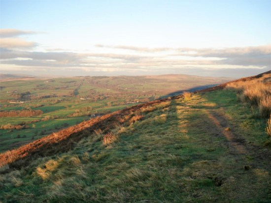
I have just enough time to take a couple of shots of the windblown tree, one of my favourites up here. That reminds me that I should venture along the Hodder and check out that other old favourite – ‘The Winkley Oak’ in case it suffered any damage in last winter’s storms. Quite a few ancient oaks blew down in the Beast from the East.

By the time I hit the road all is dark, and the cars have their headlamps on. Strangely when I arrive in the car park there are still half a dozen cars, are people camping on the fell or just misjudged how quickly it becomes almost pitch dark?

DSC02522

An hour walk snatched from the end of a glorious day.

I’m happy to switch on my gas central heating and find everything in good order, it could have gone horribly wrong as in this little ditty from the past. How many of you member it?

Flanders &  Swann: The Gas Man Cometh – YouTube

MIST OVER LONGRIDGE.

DSC02485One never knows when there could be a cloud inversion up on the fell. Last year I experienced a couple of almost perfect days up there.

The gloom down here is all-pervading. I struggle to do the daily Wordle, drinking coffee in bed. The morning is slipping away. My lane is closed to traffic at the moment for a new gas pipeline. So all peace and quiet until the gas people start drilling away outside my house. One can’t switch off easily to pneumatic drilling, so I have to get up, the rest of the week I hadn’t bothered. High pressures at this time of year gives dry and windless days but once the cloud is down it stays that way forever.

I should have taken my bike to Halton and cycled the usual way through Morecambe along the bay. But somehow I hadn’t the motivation. Taking the easy way out I decided to head up the fell. The short drive up there in mist didn’t bode well for views. I must avoid as much as possible long drives for walks next year, for the planet and my purse. It’s always next year. Parked up I was surprised by the number of cars already there.

My short walk to the summit and back was punctuated by several conversations with fellow walkers.

There were the dog walkers, lots of them, with energetic spaniels. Hardly stopping for a sniff at me, the dogs I mean, but all enthusiastic to be out whatever the weather. All very friendly. The weather was actually better than expected, no wind and almost a decent cloud inversion over Chipping Vale. Not good enough for photos.DSC02498

A couple were steaming up behind me, they recognised me, I struggled to place them initially. Friends from my lad’s school days, played in my garden and remembered me climbing up my house walls. It was great to catch up and how lovely to see how mature and pleasant people are, we are a friendly lot in Longridge, but all is changing. That gas pipe is for the hundreds of houses being built in our once tight-knit community.

The next encounter was with the fell ponies which sometimes appear. Sturdy equines milling around the trig point.DSC02487DSC02494

DSC02493The fairy or is it an angel has appeared on the fell Christmas tree, it needs a few more baubles.

DSC02497

I stop once again for a conversation with an ascending hiker  “I’m only 85 he declares” The fell is for everybody as he disappears into the mist. Let’s hope I’m still coming up here in the next decade and the younger walkers will stop and encourage me onwards.DSC02501

It’s time I did my irregular litter pick up here, there were lots of doggy poo bags and discarded tissues to remove. Maybe tomorrow if this depressing cloud persists. it must be better than the world football on TV.

A rather sad reminder of how we all did lock down. Or is it an omen for our fractured society?DSC02502

It is still foggy down in Longridge, and they are still digging up the road. I drag my rusty exercise bike from the garage to the kitchen though I doubt it will be my salvation.

A HURST GREEN VARIATION.

DSC02475With the trees almost bare of leaves we saw extra detail today on our stroll out of Hurst Green. Mike had phoned me the night before thinking it could be a dry day, at least in the morning. My knee was painful from Saturday’s walk around the Silverdale area, but I didn’t like to put him off – I have done so several times recently. I picked him up as his car was looking worse for wear after a close encounter with an HGV. He is slowly working his way through the maze of insurance reports.

Parking up opposite the Bayley Arms which is sadly once more deserted and neglected. It is a difficult time for the hospitality trade, but it would appear that it was being poorly managed according to the ubiquitous Tripadvisor. Hurst Green is in the civil parish of Aighton, Bailey and Chaigley. I’m mentioning this because Mike spotted the pub’s alternative name spelling at odds with the ‘official’. The parish is stuffed with listed buildings many associated with Stonyhurst College and estate.  The diverse architecture of the area does make it an ideal rambling venue for anyone with a historical interest. I restrain myself from photographing most of the gems passed today, well only a couple. The rest are hidden in my previous posts.

We suspect the Tolkien Trail will be very muddy, and it is becoming overused. So we head in the other direction dropping down to Dean Brook with its remnants of the water powered industries of previous centuries. Bobbin and spindle workings were common hereabouts supplying the flourishing Lancashire cotton mills. Mill races, previous ponds and evidence of damming seem more obvious today in the sunshine. The water is very lively after heavy rain. I used to bring my children and subsequently grandchildren along here, it was a favourite spot for ‘pooh sticks’ launched from the bridge and then followed downstream as far as possible. Today you would not have able to keep pace. DSC02476

I divert from the path to show Mike the abandoned Sand Quarry which provided the building blocks for much of Hurst Green. I had forgotten how extensive it had been, again everything looked clearer with the bare trees. Years ago Simon and I climbed an exciting route up the middle of the largest rock face using many of the features left by the quarrymen – shot holes and incut slots. It all looked overgrown today – nature slowly taking over.

DSC02477DSC02478

Onwards we went up the old cart track from the bridge. How many times have I photographed Greengore, an old hunting lodge, but today I found a different angle which highlighted its impressive southern frontage.

DSC02479Once on the top road we just ambled along catching up on the news, there were few cars to disturb us. Down the lane back to Stonyhurst we passed the well known Pinfold Cross commemorating a worker’s untimely death. Cometh the hour. DSC02481

And on past what had been the stables for the horse-drawn sledges pulling stone down from Kemple End Quarry, better quality than Sand Rock, to build the college and its houses. You can still follow the line of the sunken track up the fellside. The tumble down barn has been recently restored and upgraded to an upmarket holiday cottage.

We debated which route to take back to the village – go right and stay on the road all the way or continue down and follow a way through Stonyhurst College. We went for the more interesting latter knowing that it would entail a muddy section towards the end.

The college forefront was busy with coaches ferrying pupils around. The main building is under wraps for some restoration but the elaborate finials and roofline of St. Peter’s Church was just waiting to be photographed against the autumn sky. Here is my modest result – only to be approached by ‘security’ to say no photography. Why? Children’s dormitories. What in the church? I hope I don’t offend anybody with my picture.

DSC02482

The muddy stretch has been improved by a short section of tarmacked track on the hill heading into Hurst Green. We entered in by the old smithy and the Almshouses and it started raining as we drove home over the fell Cometh the hour.

***

Capturehurst green

CICERONE’S LANCASHIRE – onto the limestone.

DSC02389I find myself climbing a minor limestone cliff on a ‘footpath’ in the environs of Silverdale. That was not what I wanted with my dodgy knee. I push on, having to check my position using my phone and eventually reappear onto lanes I recognise and make it back to Leighton Moss car park at the end of a grand outing.

We are a very diverse county, last week I was in the industrial eastern mill valleys. Now I’m on the coastal fringe in sylvan limestone country. Limestone knolls and salt marches around Silverdale. I should have come by train to Silverdale Station as the guide book hints at, I reflect upon that and think long and hard how I could reduce my car mileage by taking the train in future. One problem that as I live in Longridge I have to take a bus into Preston and then walk across to the station, there is no integrated transport connection. That is just an excuse. But there again they are on strike this weekend – you can’t win.

Walk 19 of Mark Sutcliffe’s guide, Silverdale and Wharton Crag. I can’t find anywhere to park at the station so drive around to Leighton Moss, the RSPB reserve and centre. As a member I feel justified using their car park. I’m the only one without a telescopic scope heading for the causeway across the march. I wonder why there is a causeway in the first place. Halfway across is a bird hide with views across the open water.  There are swans and cormorants, ducks and geese. My camera is in for repair, I am reliant on my inadequate phone so don’t waste much time on photography.DSC02390

DSC02392At the end of the causeway a lane leads up into the grounds of Leighton Hall. This was the home of legendary Lancaster furniture magnate, Richard Gillow, it is still in the family. Today it is closed to visitors, but there are sounds of shooting from the woods above. It is open pheasant shooting season, and it doesn’t sit well with the RSPB reserve below. Do these toffs still need to carry out these barbaric practices? They can be seen heading for a resplendent lunch before making a reappearance later in the day.

DSC02401

The energetic hill ahead of me soon clears my militant thoughts. At the top there are seats with views back over Leighton Hall, the marshes, limestone escarpments and far away the Lakeland Hills. What a grand day to be out.

DSC02405

DSC02414

I relax on quiet country lanes until a sudden right turn up a steep bridleway has me huffing and puffing, the path is obvious taking me into the Wharton Nature Reserve. I have inadvertently left my trekking poles at home and miss their aid and added stability on the steep rocky ground. The limestone bedrock pokes through the surface giving a slippery passage.

DSC02416

DSC02420
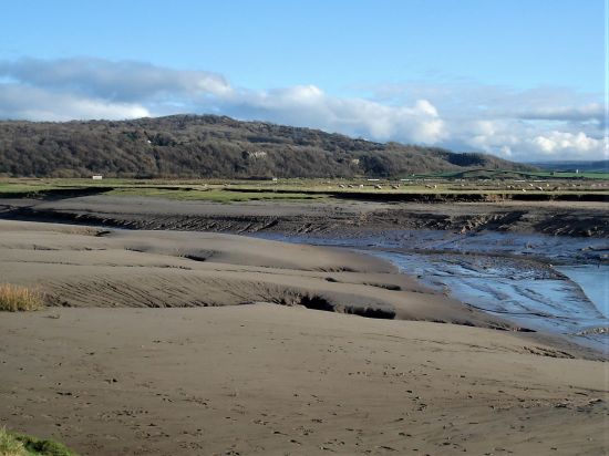
Not sure how I find myself on the summit of Warton Crag but here is the trig point and the metal beacon. I find a place to sit and look out at the view across the sands of Morecambe Bay. Checking the surroundings for stray dogs I get out my sandwich and flask. What a place for a picnic.

DSC02422DSC02423DSC02424DSC02425

Back at the bridleway, Occupation Road an old drover’s lane, which takes me down to Crag Foot with its chimney. The chimney once served a coal-fired water pump which drained land now occupied by the Leighton Moss reserve. Rising coal prices during the First World War led to the discontinuation of pumping and waterlogging of the once very productive farmland.

DSC02419DSC02436

The path across the marshes is flooded in places, but I arrive at Jenny Brown’s Point virtually dry footed. There are good view back to Warton Crag. The chimney here is the remains of a short-lived copper smelting project in the 1780s.

DSC02435

DSC02448DSC02443

The house at the point doesn’t want people using the public right of way through their property and have a plethora of Private Signs this side. I balance past precariously outside their wall only to find more helpful signs on the other side. (I love these Peak and Northern Footpath signs which keep cropping up in my posts)  In future, I will know which way to take. Presumably when they purchased the property they were aware of the right of way, I put this down to arrogance on their part.

DSC02452

The lane is familiar to me, I could have taken paths along the cliff faces, but I’m happy to stroll into the outskirts of Silverdale. It was from there that following the guide’s route felt at odds, I was clueless as to my whereabouts and was hoping ‘beatingthebounds’ would make an appearance to direct me across Lambert’s Meadow, but I made it back. Time for a brew with Sir Hugh in nearby Arnside.

DSC02460

Woodwell.

DSC02463

The cliff path.

DSC02467

The legendary Lambert’s Meadow.

Capture

CICERONE’S LANCASHIRE – the darker side.

DSC02244

I’m being unkind there, the darker side of the Pennines is actually in the White Rose county. But it is often gloomy as you drive down through these eastern Lancashire valleys with the prominent Peel Tower watching over you.

Walk 28, Holcombe Moor from Ramsbottom promised “A non-too-demanding walk from the endearingly quirky of Ramsbottom up onto the moors and back in time for coffee and cake – or a pint – in one of many inviting bars and cafés” That turned out to be a little short on the detail, both good and bad, but we are out for adventure and discovery after all.

Ramsbottom, forget the corny jokes, is, or was a solid Lancashire Mill town. Wikipedia as usual has more than enough information. It is now an apparently thriving, on the evidence of all the people there today, shopping destination. Its strength is the number of independent businesses both basic and frivolous. Parking was not easy on a busy Saturday. The station, one of the main attractions, with sometimes steam hauled trains up the valley on the East Lancs Railway was just around the corner. Only diesels today but come later and there will be Santa Specials.DSC02246DSC02245DSC02251DSC02253

DSC02254

Relics of the past.

I’ll gloss over the first stretch through a modern industrial landscape. But all of a sudden one is out into open fields with the River Irwell alongside. I’d been here before on the  Irwell Sculpture Trail which at the time seemed very short of sculptures. Today I was noticing things new like the ‘stone hedge’ bordering a field, the nod to industrial heritage on the site of Cross End Mill, (a C19th dye, bleach and subsequent textile print works) the little allotments and a modern day communal food bank.

DSC02258DSC02269

Capture Cross End

DSC02270

The path deposited me in the isolated hamlet of Strongstry, a couple of back to back streets which must have provided housing for mill workers in the past. There seemed to be a sense of community with book banks and bird feeding stations. A nice place to live.

DSC02277DSC02271DSC02276DSC02275

Now for the interesting and unexpected bit, underplayed in the book. A scramble up alongside a lively stream in a hidden, rocky, tree lined gorge. Pure delight for 3/4 of a mile and 500 feet of climbing. Well done the National Trust who care for this land.

DSC02289DSC02283DSC02286DSC02285

Out the top and across the road the character of the walk changes as open moorland is reached with increasing views over all those industrial valleys. The arrival at the top was greeted with a plethora of signs warning of the dangers of the MOD firing range, with more regulations than you could throw a bomb at. There were no red flags or explosions today, so I could happily trip along the ridge of Holcombe Moor.

DSC02300

DSC02299

The main point of interest was a stone monument erected in 1902 on the substantial base of an ancient Pilgrim Cross. The inscriptions told of the way to Whalley Abbey in the C12th.

DSC02310DSC02311DSC02313DSC02312

From there I could have made a beeline to the distant Peel Tower over Harcles Hill, but the going looked boggy, and besides, I was following Mark’s footsteps. His way was no less boggy but had views down into the steep sided valley of Red Brook south of Bull Hill. I’m not certain I took the right track; there were so many, but eventually, I homed in on Peel Tower after an arduous half hour or so, again underplayed in the guide. It was a lot taller than I had remembered, 128ft in fact, and today, as always, the destination of many family groups coming up the short way from Holcombe. Built in 1851 with a public subscription to mark gratitude to locally born Sir Robert Peel for repealing the complicated Corn Laws, which were causing starvation in the agricultural workers. Political intrigue was as complicated then as it is today. I think of him more for his reform of the criminal justice system and the establishment of Police Constables, ‘peelers’.

DSC02314

A murky tower in the distance.

DSC02317

Arduous conditions – welcome to winter walking.

DSC02322

Bull Hill – I’ve never knowingly visited.

DSC02329

Tried an arty shot with the ‘towers’ of Manchester in the background. It didn’t come off.

DSC02332

Look at the size of the figures.

I found a good stone to sit on overlooking the valley and opened my lunch box containing my lovingly handcrafted egg and tomato salad sandwich. Placing it on the stone behind me whilst I poured some hot tea. Reaching for the anticipated sandwich, it had disappeared. I had to look twice, but it just wasn’t there. The culprit was a silent poodle who must have crept up behind me; there he was, finishing off my lunch higher up the hill. I suspect his owner was hiding out of shame.

DSC02338

There’s a dog up there…     I’m on my way down.

Rested but not fed I started to make my way down steep tracks, past a Millennium Bench, and lanes through Holcombe. A mixture of old stone cottages and extravagant new properties, the former predominating the lower I went. My intention was to stop off for a pint in the Shoulder of Mutton pub and phone the plastic bag man living nearby for him to join me in what was once one of our haunts after climbing. But alas, the place was boarded up, ‘landlord needed’. It is not a good time for pubs. So down steeply, and I mean steeply, into Ramsbottom.DSC02340DSC02341DSC02343

DSC02348

A Lowry’esque church – Holcombe.

DSC02351The streets were still busy. I was disappointed to see also that the Grant Arms in the centre had closed; I stayed there on the Irwell Sculpture Trail; it was pretty grotty at the time I must admit. It is now a financial investment office. You can see why traditional pubs suffer as quite a few small bars were scattered around, offering a good range of beers often home-brewed, cocktails and a bright environment. They were all full of happy people.DSC02357DSC02355

DSC02353

Maybe here lies the answer…

DSC02359

…more likely here in a modern bar.

I was pleased to see that the welcoming Chocolate Café across the way was still in business; it was always a haven on shopping trips. All things chocolate.DSC02358

Anyhow, a change of plan, and we were soon sat in The Garsdale on the edge of Bury enjoying a beer and chewing the fat, as they say in these parts.

A superb varied walk full of interest but a little more demanding than Mark suggests, or am I getting old? Surely not. Thanks for sticking with me.

CaptureRamsbottom.

CICERONE’S LANCASHIRE – Easington Fell again.

DSC02193

My usual ploy of a leisurely start to the day, drinking coffee, catching up with the news and maybe a crossword or two seemed to be sensible as the rain hammered down. Another coffee whilst I scanned the Cicerone Lancashire Guide for an accessible walk more testing than the Blacko one a couple of days ago, delightful though that was. (Today’s turned out to be a tough test of eight difficult miles)

This post became rather long and rambling, I can only apologise now.

I was soon driving out to Grindleton in the Ribble Valley. Several flooded roads did not bode well, perhaps I should have brought Wellingtons. But the forecast was for improvement, and I’ll go with that. The route in question , Walk 20, included an ascent of Easington Fell. I’ve been up there many times. A good friend used to live in Grindleton, and we often did circuits above the village. The last time I was up there was in lockdown 2020 when I approached from the north out of Harrop Fold. The day did not go well, and I was lost for some time (more than I would like to admit) in mist on the fell. I did not want a repeat of that fiasco. 

I parked in Grindleton which looked rather sad with both of its pubs closed. They were working on one, formerly the Buck Inn, but progress is slow. The Duke of York sits forlornly on the opposite corner.

DSC02241

The Duke becoming derelict.


DSC02242

Not likely! The old Buck Inn, why the name change? Looks like corporate management.

I walk through some lovely woodlands and above the old Greendale Mill originally powered by the lively valley stream.

DSC02162DSC02163DSC02164

I found this on the internet, TCW.

In the 1850s and 60s a quarter of the adults in the village were hand loom weavers of cotton, but industrial mills were being developed apace and depriving the domestic workers of their livelihood. It would have been seen as a benefit to Grindleton when a mill was built there, providing jobs without the workers having to make arduous journeys further afield, perhaps to Preston or Blackburn. Greendale Mill was built in about 1868 by the Grindleton Industrial Association Ltd with space for 180 looms. It straddled a brook and was driven by a water turbine and a 15hp steam engine, which was powered by a huge coal-fired boiler 7ft in diameter and 25ft high. By 1871 the mill had been leased to a tenant, Timothy Marsden. He employed about 50 people and had 100 looms.

At about 12.50pm on Tuesday, September 26, Marsden was seen stoking the furnace to get the boiler steam pressure up. Two or three minutes later there was a shattering explosion. Shocked mill workers rushed out and saw the boiler house had been blown to bits. Masonry and roof slates lay everywhere, covering the surrounding fields up to 200 yards away. A pall of steam hung over the mill and the surrounding area, and there was a deathly silence.

Three or four men entered the boiler house and found the boiler had been torn from its brick setting and thrown across the room, its metal plates ripped apart, and the rivets sheared through. Timothy Marsden was lying on the floor, an oil can in his hand, gasping for air and making rasping sounds. He was severely scalded on his back, arms and legs, and he had a deep gash on his head.

The workers carried him into the cotton warehouse and a doctor arrived. Slipping in and out of consciousness and deeply shocked, Marsden asked what had happened and when told he said, ‘Poor me! What shall I do?’ With some difficulty his clothes were cut off. He asked to be taken to his home in Darwen, about 20 miles away, so he was carefully wrapped in blankets and loaded on to a horse-drawn cart for the journey. The doctor tended to the terrible scalds and the head wound for the rest of the week, but Marsden contracted lockjaw and died on the Sunday night, five days after the accident.

An inquiry was held at the Duke of York Inn, a few hundred yards from the mill, on the afternoon of Tuesday, October 14, and the jury returned a verdict of accidental death.

Damage to the building cost £500 (about £60,000 now) to repair, and the mill was not fully operational until early the next year. Cotton manufacturing continued until 1930. After that, felt was made for hats, and then engineering components. In 1960 the site was acquired by a haulage firm. It is now a storage facility. 

The area round the mill, about 20 acres, is now owned by the Woodland Trust which planted it with broadleaf trees in 2000 to commemorate the Millennium. There are a number of damson trees to reflect the fact that Grindleton was once home to a jam factory.

I thought that was worth the read.

Now on Green Lane leading up the fell. At one time this was a pebble stoned way. Bits of tarmac keep appearing to give access to the scattered houses. 

DSC02167DSC02169DSC02168

I remember White Hall from some previous visit. Its price is now £2 million. 

DSC02170

DSC02172

A touch of colour on the way.

Upwards and onwards I pass the extensive grounds and properties of Cob House. One of the grandest overlooking the Ribble Valley and no doubt valued at more than £2 million. I often muse as to who lives in these mansions, local businessman come good or a crook doing bad.

DSC02173

A little farther up a Bridleway slopes off to the left into a valley with the isolated Simpshey Hill straight ahead. My memory clicks back to 1989 when I was introducing one of my son’s to off-road ‘cycle packing’, the other son has more sense. We camped down by the little stream and were surprised if not scared by a large black mink approaching us as we cooked our beans. We didn’t sleep easy. That was the time when animal rights activists were releasing the animals from the mink farms, much to the detriment of the local otter population.

DSC02175

Simpshey Fell and valley.

DSC02178

West Clough Brook.

I worked my way around Simpshey and then Easington Fell with its forest appeared, it looked a long way. In fact, I ended up walking continuously uphill for nearly 4 miles and was glad of a sit down on an old wall for a bite to eat. From up here Pendle was prominent on the horizon, as always, and swinging round the Bowland Fell were all a bit hazy in the moist atmosphere.

DSC02182 (2)

The long way up to Easington Fell in red.

DSC02184I knew that the next section around the north side of the forest would be hard going. I aim for a pile of stones, marked as ‘The Wife’ on some maps.

DSC02188

The wife.

From there is rough ground, climbing the ‘rusty gate’ mentioned in Mark’s guide, up to another pile of stones marking the summit of Easington Fell, 396 m. (Header photo) The good views into Yorkshire and the Three Peaks were obscured, but I could see my way along the plantation edge. What is not readily apparent is the condition of the ground, it deteriorates into a reedy boggy nightmare where I was concerned I would sink without trace. By now the wetness had spread up to my waist, and I was tiring in the heavy going. I was looking for a way through the forest and was concerned it maybe blocked by all the storm damage from last winter. The easy option would have been to continue outside the trees on an undulating course to Beacon Hill, but I was keen to follow the guide. An indistinct post showed the way into a fire break which thankfully was clear of fallen trees.

DSC02191

That rusty gate – first of many obstacles.


DSC02205

Distant Beacon Fell.


DSC02206

Rough going – what lies beneath?

DSC02202

DSC02201

Trouble ahead?


DSC02208

That elusive fire break.

At its end I joined the Shivering Ginnel, an ancient walled route through these hills. ‘Shivering’ because it was so often a cold north-easterly wind that blew through here.

DSC02209

Shivering Ginnel.


DSC02210

How many have passed this way.

It was a relief to break out onto the open moor at Beacon Hill. The ground around the summit seems to have been disturbed, mining activity or a more ancient burial ground? Does anybody know?  Pendle has to appear in the background of the Summit photo. The River Ribble is somewhere down below.DSC02212DSC02217

DSC02213I’m soon off the fell and on a lane past Scriddles Farm. Don’t know the derivation, but we have had some lovely S’s today – Simpshey, Shivering and Scriddles.

Across a stile is a ‘Shepherd’s Hut’ with a great view and the obligatory ostentatious hot tub – but who uses these bacterial baths especially with a public footpath coming through. DSC02219

DSC02220The next mile or so was not the best, unmarked paths and crumbling stiles. To make matters worse the afternoon light was rapidly deteriorating. I followed this way in reverse a while back with Sir Hugh and The Rockman, we struggled then but the intervening years have not been kind to all those stiles. Most were difficult and a couple downright dangerous. The guide underplays this section, some acrobatic agility is needed together with the more detailed 1:25000 map, I resorted to phone navigating technology and the landowners could be more helpful.

DSC02222

Slowly rotting away.


DSC02224

Rights of way have a knack of disappearing in horsey country. I’ve nothing against horses.


DSC02225

Somewhere down there.


DSC02226

Don’t look down.

I was glad to reach the ancient sunken track leading straight back to Grindleton.

DSC02233

DSC02227

Jelly Ear fungi – edible but just too nice to pick.


DSC02166

Any ideas?

There is a choice of ways through the village – the Main Street with some impressive houses.  or the back ally with its cottages. Little ginnels run between the two, and I notice there is a marked trail around the village.DSC02236DSC02237DSC02239DSC02238DSC02240DSC02159

A pleasant place to live apart from those two derelict pubs. 

CICERONE’S LANCASHIRE – Gentle Pendleside.

DSC02123I

It’s been a while since I walked alongside Mark Sutcliffe, he of Cicerone’s Walking in Lancashire guide. Apart from a short road walk around Longridge Fell with JD the other day I’ve languished in the house. Time to get going again and test my knee out. I scan the chapters looking for something undemanding. I toss up between Blacko hills, (Chapter 27) and the Clarion House walk on Pendle. The former looks the easiest, even if the latter looks the more interesting. The fact that it was Halloween Eve never crossed my mind as I delved into Pendleside. On reflection the immediate Pendle area would have been chock-a-block. (I like that word)  Lucky choice.

My mood in the morning was as gloomy as the weather, but I had enjoyed that extra hour in bed. The weather improved alongside my mood, I was just glad I was in the car post walk when the afternoon deluge hit the area. The M65 virtually came to a halt as the skies blackened and gallons of water came down from somewhere. I’m now safely home.

Let’s park up at Higherford, there is a bridge here now over Pendle Water. I struggle with the car park machine, ‘it’ knows I’m here and will charge me later on my return – that preys on my mind for much of the walk.

Across the way is Pendle Heritage Centre. I think I was too early for its attractions – tearoom. gardens and museum. Maybe later but then it is too late. Park Hill House below has associations with the Bannister family later to run the sub 4 minute mile. I do spot the first Tercet on The Lancashire Witches Walk .DSC02105DSC02104

Alongside the water I get into my stride. Autumn is everywhere. There are reminders of previous mill operations, but I am soon out into the countryside.DSC02114DSC02119DSC02120

DSC02118

DSC02122

I’m heading towards Blacko Tower.

 A plaque reads Built by J Stansfield1890 Restored 1950. Approximately 30ft high. Built as a folly. Circular. Coursed rubble. Widely spaced battlements. Two steps up to a plain doorway. Spiral stone staircase inside leading to observation platform. Prominent hilltop landmark. 

Such a shame there is no public access, it must be a fine viewpoint. Time for the citizens of Blacko to stage a protest march. I make a mental note to return mid-week and make a clandestine ascent.DSC02127

Today I’m content to follow vague contouring paths on the rough hillside past farms to Malkin Tower Farm. Maybe the site of a ‘witches coven’ in 1612 from where the women were marched off to Lancaster to be tried and executed. There is lots of speculation as to the true version of events. All is quiet today with the farmer’s wife subtly showing me the diverted way. A few arrows would have helped, but all is mysterious around here. DSC02129 At the next farm I weave through a complicated series of gates in their garden. Enquiring of a lady, to confirm my way, that few people walk through here – she says “most get lost”. I doubt the irony strikes her. Again a few yellow arrows wouldn’t go amiss. At last, I’m free and walk down a lane to another farm, Whitemoor Bottom. The guide says take the footpath on the right, but there is no obvious way –  I strike boldly through the farmyard and onwards down the fields. This is horsey country and barriers keep appearing, is it this side of the wires or the other? Determination sees me through, and I drop into a wooded gully with little sign of others coming this way. But I’m on course and eventually come out onto a lane at Holly Bush Farm. Sand Hall, which looks as though it should be listed, is passed, and the lane takes me to Foulridge Reservoir.DSC02132DSC02135

DSC02136

Time for lunch, so I climb up to the dam for a bird’s eye view of the reservoir. It’s depleted of water and the only action from the sailing club is a model yacht race.DSC02137DSC02144

A bridle way takes me to join the canal as it emerges from the mile long Foulridge Tunnel, completed in 1796! A way mark confirms it is the Leeds – Liverpool Canal. Maybe I should walk its historic length one day.DSC02146DSC02149DSC02150

DSC02154

Halfway down the locks a path takes me through a pasture and into an upmarket estate. As I progress down the main road the older stone houses typical of these mill villages appear, Weavers cottages now desirable properties. On the corner by the packhorse bridge is the old toll-house (early C19th) with a board listing prices – almost as complicated as the pay machine in the car park.DSC02115DSC02106 (2)DSC02107

A good start to my winter walking, shorter than the guide book suggests, and not a ghost or witch in sight.

DSC02121

*****

Foulridge

A BREEZY BEACON.

20221017_142335

Funny how the day turns out. I’ve been festering in the house for a few days due to some minor medical problems – but you don’t want to know about them. Midday I drive to the supermarket for supplies, why don’t I walk as it is only 500 m around the corner? I’ve just not felt like exercise as I said. Emerging after yet another troubled time with the self-service till, I do so much prefer a chat with a friendly cashier,  (We are becoming so isolated from each other, have you noticed?) the brilliance of the day hits me. Blue sky, warmish sunshine and a pleasant breeze, ideal for a walk.

I ponder where would be best for a short walk. Longridge Fell above me is an obvious choice, but I have come unprepared in lightweight trainers and I suspect after our recent rain the going will be boggy. Across the valley the Fairsnape/Wolf Fell ridge looks inviting, but again I only came out to buy a few vegetables. However, slightly dwarfed there is Beacon Fell; good paths, good views and a café. Perfect for my present ambivalent mood – at least I’ll get some fresh air.

Narrow confusing country lanes take me across Chipping Vale and up to the free of charge Quarry car park. A gang of three volunteers are cutting back the vegetation. The country park relies on volunteers, a pang of guilt passes by me. Strangely mine is the only car in the quarry.

I set off in a clockwise direction on the well maintained paths not too worried about which one I take, they all lead to the same place, eventually. It strikes me that I was originally inspired to get some exercise because of the sunshine and I now find myself deep in the rather gloomy forest. Never mind I soon come out into the open near the main metered car park and visitor centre. The café here prided itself on being open 364 days of the year, but I find it closed today. Another aftermath of Covid. Thursday to Sunday only now, what a shame, will it ever now make a comeback?

I wander up to the Orme Sight statue by Thompson Dagnall, I think the original art installation in the park. Looking through his one eye one can see far away, yes the Orme on the North Wales coast.

From here I take minor forest trods upwards. Most of the storm damage which I experienced here last time has been cleared, must be all those volunteers again. There is not much sign of Autumn in the woods as nearly all the trees are spruce. I find myself on a ‘Sculpture trail’ and spot one or two new to me. Then I confidently find the correct path to the top of the Beacon with its trig point. There is nearly always someone here enjoying the view.

“The triangulation pillar is situated on the site of where the beacon would have stood. Records show that there was a beacon here as long ago as 1002 AD. Later maps show it as part of a chain used to warn of impending danger such as the approach of the Spanish Armada in 1588. More recent beacons have been used to celebrate such occasions as coronations and jubilees. Rising to a height of 266 metres above sea level the summit gives fantastic panoramic views of the Bowland Fell and Parlick Fell, with the coast beyond, Morecambe Power station and Blackpool Tower.”

I’ve seen it all before and as it is blowing a hoolie at the summit I move on quickly along the northern side of the hill to find a way towards the car park. I’m still the only car parked up which I strangely find a little spooky. A good 2.5 mile unintentional walk in and out of the trees. I was glad I had come out to the shops in the first place. Back at Craig Y a friend was going through the motions on the start of the traverse. I delayed him with talk of Warhol, Amsterdam, trees and Truss.

20221017_145645

Losing the sunshine.

20221017_151138

Cleared storm damage.

20221017_150927

Orme Sight.

20221017_151325

Toady.

20221017_151343

A ‘green woman’

20221017_151838

The breezy beacon.

20221017_152552

The spooky car park.

I’m looking forward to an even better day tomorrow.

ALMOST FORGOTTEN PATHS.

P1090463

I have not pulled my boots on for a month or so. Today was too windy for cycling, so a short local walk was in order. Do you remember those days of lockdown when only short excursions were allowed – I stuck to the rules. I walked through the fields to Gill Bridge, on through Ferraris country hotel (doing takeaways only) and back along the almost empty road. I repeated the same walk or variations many times, using hand sanitiser after every gate latch or stile. Others had the same idea and the footpaths became well trodden and easy to follow.

We are two years on from there, most of us have had Covid and thankfully survived and life is moving on. We are however faced with another batch of problems, but let’s not dwell on those today. It’s time for some fresh air and exercise.

I repeat that same four mile route from my house. It does not look as though many others are walking the paths. They are overgrown and unloved. No need for hand sanitiser any more, did it ever do any good? The views have not changed, and I’m surrounded by the Bowland Fells and Longridge Fell. The clouds blow through in the blustery winds with odd bursts of sunshine.

I find chestnuts, ‘conkers’, where I hadn’t realised there were chestnut trees. A handful go into my pocket for planting later and while I’m at it collect some oak nuts, acorns. Beech nuts are in profusion along the roadside. Unidentified fungi are seen in the fields. Hawthorn berries add a touch of rouge to the hedgerows.

P1090457

Into the outdoors.

P1090466

Becoming neglected.

P1090458P1090468P1090473

P1090471

P1090462P1090472

Autumn’s fruitfulness is our bonus for this splendid short rural walk on my doorstep. My spirits are lifted, and our other problems put in their place.

I mustn’t leave it so long before I next tread these paths, they don’t deserve to be forgotten.

NICKY NOOK ONE MORE TIME.

20220826_154441I arranged a walk with my son today whist he is off work and I took him on a repeat of one of his early childhood walks of which he had no recollection – the classic Nicky Nook circuit from Scorton.

This involves parking near the local parish church, St. Peter’s, famous for its steeple, a landmark visible from the M6 going north. The time was 3.00.

We didn’t mess about on field paths low down, just walked up the quiet lanes until there was access into GrIze Dale. I always enjoy the stroll up this deep wooded valley, today there was only a trickle of water in the beck. The Grizedale Reservoir was the lowest I have ever seen it.20220826_155601

Walking up the gentle side of the hill we started to meet more people, but generally the place was deserted.

20220826_162215

That’s not the top.

We stopped at the freshly painted trig point to take in the views over the Bowland hills, the motorway snaking north, Morecambe Bay and the Fylde. That is why most people come up here.

20220826_163022

This is.

Down the steep side and into Scorton where we take the lane to the church whose clock now says 5.30.20220826_165109

20220826_172246

An innovative sign.

20220826_172430

Time for a beer and a Chinese meal back in Garstang. He still didn’t remember the childhood walk but enjoyed the excursion, it’s good to share.

CaptureNicky Nook.

CLANDESTINE CLIMBING.

20220813_115102 (3)

                                                                         The secret crag.

There are few photographs and no maps in this post, I’m sworn to secrecy.

Any climber will admit to you that if he comes across a cliff face that apparently hasn’t been climbed on he keeps it very much to himself until he has climbed all the routes or at least the ones he is capable. Climbing lore is full of Crag X’s. I’ve known climbers spend hours on Google Earth trying to spot unknown crags. The protagonists will go to all lengths to ensure their apparent rivals don’t come across the location. Leaking the wrong grid reference or the wrong county if they think they could be robbed of the new route’s kudos. Talk of going to Wales this weekend when in fact they are sneaking into the Lake District. There are tales of car chases to try and follow the new routers to their new crag. Many a secret has however unfortunately slipped out over a few, too many, beers on a Friday night.

New routes on an already well climbed out crag are more difficult to hide before completion and there are many tales of rivals stepping in and ‘pinching’ the route from under the noses of the originator. A nonclimber will say isn’t the rock available to all, there are no property rights. But if a team have spent hours if not days cleaning, and in these times on certain crags placing expensive protection bolts, then they feel they have an unwritten right to first go. There was always a certain climber’s ethic and code protecting this ethos.

The first ascentionist’s list in climbing guide books is always of interest, if not heated debate in some circumstances. There is a wealth of tradition and history contained within. The top climbers satisfied with a select list of quality climbs to their name. Others have produced a plethora of named routes of dubious quality that rarely see anyone else climbing.

To be honest most of, if not all, the decent climbable rock on our small island has been identified. You just need to take a look at UK Climbing’s map to see that even the smallest and most esoteric pieces of rock have been climbed on. However, in recent years the popularity of bouldering, smaller rocks without ropes, has broadened the perception of what is possible away from the traditional areas.

I’ve modestly developed a few rather grotty quarries on Longridge Fell, non are popular but occasionally someone comments on a good route which is satisfying.

I remember a walk, 45 ago, up the Croasdale Valley one winter’s day looking at some craglets, Bull Stones, marked on the OS map. (Aren’t we lucky to have this fantastic mapping source, the envy of the world.) There was lots of rock but little of it high enough for roped climbing as was the norm then. I dismissed it. Step forward 20 years and the sport of bouldering has mushroomed. Every boulder, no matter how small, can be climbed by a variety of ways with just your rock boots and chalk bag, no rope required, Bouldering mats, a safety pad to soften your falls appeared later. That blurred vision of Bull Stones resurfaced, and I mentioned to my climbing partner Batesyman the possibilities up there.

The next weekend we were hiking up there, dodging the gamekeepers, and like kids in a sweetshop climbing everything we could. Bouldering mats were purchased and our boldness multiplied. Over several months we systematically climbed and charted over 300 problems on the extensive edges. M  (see below) himself joined in on some new routing. Thankfully the 2004 CRoW act gave access to many previously forbidden upland areas, particularly in the Bowland Hills, a bastion of grouse shooting. ( by the way they will be at it this week – the glorious 12th has passed) I produced a PDF guide to the edge, and it has been incorporated into Robin Mueller’s exhaustive Lancashire Bouldering Guide. If you are interested there is a delightful video http://vimeo.com/183222521

So when I receive an email from M.    How do you fancy helping me develop a crag that I have found? Between 10 and 20 m high?”

I’m hooked and despite my unfitness I was only too keen to join in the fun. I obviously had reservations of what could be new? A drive south on long forgotten roads. M and his wife have bought an isolated property in a secluded valley to start a new life. A lovely C17th farm house with flagged floors and low ceilings.

A walk on what is one of the hottest days of the year brings us to the crags where thankfully there is a pleasant breeze.  M shows me the first buttress – I’m blown away. Perfect rock, up to 20 metres high with cracks and breaks. I struggle to follow him up the first new route which he climbed on sight. There was a heart stopping traverse move at half height where you leave a crack and blindly grope for a rounded layaway flake.

His next offering, again previously unclimbed though cleaned this week, involved some very steep moves which I found impossible with my injured left knee, lots of undignified shuffling to get my right leg onto the nose and up to more interesting climbing on immaculate rock. A good lead from M, I couldn’t have done it.

Refreshed by sandwiches and fluid, and it was time for his ‘triple buttress’ route.  He had done this before but wanted my opinion of the grade – to be honest I found each of its three sections hard and thought-provoking, probably at least 4c/5a, harder than the other routes had been. But I’m not fit, so maybe I’m overestimating them. M is climbing well, and I’m impressed with the quality of the routes.

We were both exhausted from the climbing and the heat and agreed we had had enough. Back at M’s cottage we went down to the river where there is a secluded swimming pool. The cool water was so refreshing. Wouldn’t you all love this on your door step this weather? The day was topped off with tea and scones.

20220813_175541

The secret pool.

M will be busy prospecting new lines and I can’t wait to join him again.

BLEASDALE CIRCLE REVISITED.

P1090212 (2)My son had never been to see the Bleasdale Circle despite having walked around the Bleasdale estate since he was a young child. In fact when I think about it, we pushed him round in a ‘buggy’ when he was barely one. I had to remind him that was 50 years ago!

I must have a dozen or more posts regarding Bleasdale and have mentioned the Bleasdale Circle several times. Things didn’t look right today as we took the concessionary path towards the circle – the trees which enclosed it have virtually gone, I had to take a second look. As we came closer it was obvious that there had been severe storm damage since I was last here and the remaining trees harvested. To be honest the whole site looked a mess, all very disappointing, it’s going to need some loving care to make it presentable once more. The concrete inner ‘posts’ were still in place, but the interpretation board was undecipherable. The views from up high on the fells will no longer show the prominent circle of trees marking the site. See my previous photos here.

P1090213P1090214P1090215

I quote from previous posts –

The circles are Bronze Age and were originally oak posts, an outer and inner ring. Discovered in 1898 and subsequently excavated they yielded a central burial chamber with cremation urns and ashes. These are now on display in the Harris Museum in Preston. The inner ring of wooden posts have been replaced with concrete posts. The orientation of the posts within the circle of the Bleasdale Hills may suggest some deep reason for their siting here.  

Here is the official listing for it.

We walked on around the estate at a slow pace as the temperature soared. Our plan was to finish the walk just before six when the Cross Keys Inn at nearby Whitechapel would be opening. The plan worked, and we enjoyed a beer and a good meal.

Capturecross keys.

CICERONE’S LANCASHIRE – back on the trail.

P1090151It’s two months since I was last able to do a walk out of Mark Sutcliffe’s guide book. Finding one locally I strode out today on his Jeffrey Hill chapter. The suggestion was to park at Little Town Dairy, a farm shop, nursery and café. I feel guilty using a businesses’ car park if I’m not giving them any business so I parked by the road higher up on the route, which was to prove tiresome later in the day.

I had reservations about the initial route through the upmarket barn  conversions at Dilworth Brow Farm, previously a run down property. There was no need to worry, the path through was obvious, and even the local dog was friendly. Every farm seems to be erecting holiday lodges, Is this a result of the recent ‘staycation’ mentality?

P1090114

An uncertain start.

P1090117

Dilworth Brow.

P1090122

Once into fields I could enjoy views over the Ribble Valley and distant Pendle as I dropped to an ancient bridleway. Being enclosed and sunken this was once a boggy mess, but drainage has been installed and an upgraded grit surface added. This was only a short section of the right of way, one wonders why certain paths are improved (a further one later) when others are neglected.

P1090126

Note the size of the left-hand gatepost.

I made the obligatory short diversion to view the Written Stone, I have written of this before,excuse the pun. A car passes down the farm lane, I thought I recognised friends from years ago and regretted not stopping them. As I walked through the tidy environs of Cottam House I asked a man about the history of the place, he turned out to be the son of the above couple. So we had a catch-up, I passed on my regards and walked on.

P1090129

The Written Stone.

P1090130

This was the start of a slow climb back up to the ridge of Longridge Fell. Rough ground skirting the golf club and then the road up to Jeffrey Hill at Cardwell House. A large walking group was coming past and didn’t seem over friendly, head down mentality. There was a straggler taking some interest in his surroundings. We ended up in a long conversation about all things, as he said “it’s not dark till late”. I felt he had lost connection with the route march he had been on. Nobody came looking for him.

P1090133

Up to Jeffrey Hill.

P1090137

The Ribble Valley and Pendle.

P1090140

No time for stragglers.

I took a picture of the iconic view which I mentioned in a recent post. A ‘glass wall’ has replaced the iron railings depicted in the painting I own from 40 years ago.

P1090145

That view from Jeffrey Hill.

Nearby was a bench for refreshments. Some stones had been intricately carved as part of an art sculpture from 2014, It was a shame they removed the star of the installation, the Sun Catcher.

P1090142

Remains of the sculpture installation.

Now steeply downhill, look at the contours, ending up on the road at Thornley Hall. The ford leading off the road was surprisingly full. The next bit of track starts as a track but quickly becomes an overgrown narrow path, the book advises a stick for hacking back the vegetation. I happily swashbuckled my way along and at the end came onto another strange short stretch of gritted path.

P1090150

Looking back up to Jeffrey Hill.

P1090154

The listed C18th Thornley Hall.

P1090157

The ford.

P1090158

A promising start to the bridleway…

P1090165

…soon becomes this…

P1090168

…and then unexpectedly this.

Familiar lanes took me past Wheatley Farm and a house that always has a splendid floral display. Onto the busy main road where care is needed on the bend. I was glad to be back in the peaceful fields of Chipping Vale under the Bowland Hills. Heading towards Little Town Dairy where I could have parked at the start, but no I was faced with another steep climb back onto the fell. I reckon I had climbed over 1000ft in the 7 miles which took me 4 hours including all those stops.P1090169

P1090172

Wheatley Farm, 1774.

P1090174P1090175

P1090177

One has to spend one’s money on something. 57 has gone shopping.

P1090178

Parlick and Fairsnape.

There was one more encounter at Sharples House. The farmer there had previously talked of having the largest cheese press in Lancashire, I believed him. In the past many farms in the area made their own cheese, tasty Lancashire. Today he seemed in a good mood, so I enquired further, and he took me to see the stone, it was indeed large and must have weighed a ton. He explained that the house was from the late 17th century. A former occupant, a Peter Walken (1684-1769) had been a nonconformist minister as well as a farmer. Uniquely he kept a series of diaries, most have been lost but two from 1733-34 have been found and published by a researcher from Preston museum. The present farmer was contacted and was able to see the journals but described them as boring, though they must have given an insight into farming life in the first half of the 18th century. He also told me of a mystery from the last century when two thieves broke into the house killing the farmer, but the daughter perhaps escaped hiding in an adjacent barn. One wonders how much local history has been lost.P1090183

There is another mystery just along the lane at Birks Farm – what is this structure in the wall built for? I should have asked the last farmer, next time.P1090184

Up the steep lane, over the last stile and I finish this splendid walk back at my car overlooking Longridge.P1090186P1090189P1090190

***

Capture

A BLOGGERS GIFT.

P1090093

                                                                                    Beacon Fell.

My friend and blogger Sir Hugh, conradwalks , often talks of ‘a bloggers gift’ Some unexpected happening or conversation that brings the story to life. He seems to collect these occurrences on a regular basis, many of them centred around a cup of tea with complete strangers. I’m secretly jealous.

Picture the scene – we are walking down a country lane when a man recognises me and enters into conversation. We are just passing his house, and he suggests showing us around his garden. We are not rushed for time, “Yes we would like that” was our innocent reply. The garden was large and unruly with many interesting plants. His main passion was apples and he had many varieties, most grafted onto stock by himself. We had finished the garden tour when his wife offered us tea, we couldn’t refuse. Next thing we were seated in the garden with tea and chocolate birthday cake. Talk was inevitably about the old times, we had many shared acquaintances.

As we came away after a good hour in their company I realised I should have had a photo of the occasion – a bloggers gift. Too late, what a missed opportunity.

Anyhow, here are a few photos from our stroll around the Whitechapel area beneath Beacon Fell. The emphasis was on beautiful Lancashire pastures with extensive views and on the multitude of very expensive properties, you don’t get much for less than a million. Mike was prospecting a possible route for a walk he is leading later in the month starting and finishing at the newly refurbished Cross Keys Inn.

P1090090

Whitechapel St James Church.

P1090092

Into the fields.

P1090095

Himalayan Balsam in profusion.

P1090096

Hydrangeas at Crombleholme.

P1090098

Modern day fencing.

P1090100

Wood Fold.

P1090105

P1090106

Barnsfold barn conversion.

P1090111

C17th Ashes Farm, moated.

P1090112

Cross Keys Inn, closed on a Monday lunchtime

***

Whitechapel

LITTER ON THE FELL.


P1090076

             Longridge Fell looking across the green Chipping Vale towards the Trough of Bowland.


At the risk of raising the blood pressure of my, environmentally sensitive, readers – read on.

Following on from my brush with Covid I  have not kept up with the walks featured in the Lancashire Cicerone Guide book. I hope to resume them shortly. Today I needed a gentle leg stretcher – Longridge Fell always has something to offer. I’ve not done a ‘litter pick’ up there for several weeks so that became the object of the morning’s stroll. 

Parking up I was immediately confronted with discarded pizza boxes and drink bottles , also strangely two plastic motor oil containers. There is a litter bin 10 metres away, though admittedly it is usually full to overflowing. Not a good start to the day. P1090074

I set off on my walk intending to clear this mess up when I return, it won’t all go in my bag. Longridge Fell was bone dry making for easy walking though the threats of moorland fires must be high. I noticed the bilberries were very small perhaps a reflection of our lack of rainfall this June and July. The other thing that struck me was that the heather was already blooming – I seem to have missed some seasons this year.

P1090075

A sad finding on the ridge was a recently dead Kestrel. I could see no signs of it being shot, but I did wonder afterwards about possible poisoning. Should I have picked it up and sent to the RSPB or police for toxicology tests?

P1090077

Up to the trig point and back in a circle I half filled my bag with the usual doggy poo bags, drinks cartons and food wrappers. The short stretch on the road at the end provided an equal amount of rubbish dumped out of passing cars. All I had to do was pick up the rest of that rubbish in the car park. 

This is a local beauty spot with a fine view of Chipping Vale and the Bowland Hills so there are always cars parked here. In lock-down it was a free for all with all the verges taken over, things are back to normal now. Today I noticed two artists busy painting the scene. I wandered over to have a chat and admire their work. One was using watercolours and the other acrylic, they both complained about the high temperature affecting their paints. What a talent to be able to capture that view with a few brushstrokes. I wish I had asked them to email me a copy of their finished paintings.  That reminds me, I have on my study wall a watercolour of the very same scene done for me by a Mr. A Long, an artist who lived in Longridge 40 odd years ago.  

P1090086

P1090085

P1090089

Mr Long’s painting.

What a contrast from two gents fully appreciating their environment to the louts who drive up here with their takeaways and don’t take them away.

A COUNTRY LANE.

P1090044 (2)

I used to be able to recognise and name most of the wayside flowers. As part of my A Level Botany course we had to present a collection of pressed and dried flowers to the external examiner for an intensive viva. I’m talking of 60 years ago, I suspect the modern day student will not of heard of external examiners and vivas. Being the sad git that I am, I still have my folder of dried flowers, about 200 species all classified and labelled precisely. I may fish them out and show you my diligence.

Time passes by and one’s interests widen, but I have always tried to put a name to plants as I pass by, but I admit to becoming a bit rusty on those once familiar names. At my age one starts to worry about dementia but all my friends struggle too. Annoyingly that elusive name will often surface at a later time. Anyhow, to brush up on my plant recognition skills I decided to upload an app onto my phone that would help me on those I had forgotten. I know I’m behind the times with this technology.

There were several to choose from, and eventually I chose one. I pointed it at an Ox Eye Daisy and it only told me that it was from the Asteraceae (daisy) family. That didn’t seem to be good enough, so I tried a few more. None were particularly accurate or quick to respond, maybe it’s my ageing Android phone. I searched ‘best plant apps’ and eventually settled on iNaturalist. Time to put it to the test.

A local walk I often do involves a pleasant almost traffic free lane. They call it Mile Lane despite the fact that it only measures half a mile. My mission today was to try and photograph and identify every flower seen on this short rural stretch of Lancashire. Last time I was out I was solely on the trail of the Bee Orchid – today I would be content with a Thistle or Dandelion.

That half mile took me far longer than usual as I searched the verges and hedges for as many plants as possible. Rather disappointedly I only counted 25 different species. (Grasses weren’t included, that would have been a step too far.) I recognised the majority of them but was stumped by one which my app told me was a Hedge Woundwort, Stachys sylvatica. I wasn’t aware of its pungent smell, next time I come across it I’ll check that out. Its common name suggests it was used for dressing wounds, no doubt having some antiseptic properties.

I was not impressed with the iNaturalist. It took a long time to register the plant and often gave a rather vague identification. I admit my phone is not the best for photography which may have a bearing on the results. If any of you have a suggestion for a favourite plant identification app I would be very grateful for your advice, I’ll try it out on a different lane.

P1090051

 Hedge Woundwort.

CICERONE’S LANCASHIRE – To the points.

I’ve never been fully around Sunderland or Bazil Points so walk no 18 in Mark Sutcliffe’s Cicerone Guide to Walking in Lancashire was an attractive proposition especially as it was flat as a pancake which suited my crumbling body.

I have a fear of rising tides, so the logistics for this walk were important. Tide timetables were consulted and double-checked, last Saturday looked good with a low tide at 9am. Unusually for me, I was parked up at Overton at 9am. Would my car disappear under the waves whilst I was out, I said I was nervous about the tides around Morecambe Bay. Remember the disaster in 2004 when at least 21 Chinese illegal immigrant labourers were drowned by an incoming tide whilst picking cockles off the Lancashire coast.

There was little sign of water as I walked across the causeway, just mud and marsh grass in all directions. The Sea Thrift gave the area a pink glow. A few cars passed heading to town. Soon I was at the few houses that call themselves Sunderland, once the major port for Lancaster and beyond. I wrote of the history of this place when I visited in October last year.

That time I was on my cycle so didn’t go right round the point itself. Today I continued past the last house onto the rocky shoreline and found a place to sit at the very end looking out over the Lune to Cockerham and distant Knott End. There was Plover Lighthouse seemingly on land today. As the tide was well out there were virtually no waders on the shore, just the odd shelduck, but curlews were calling in the fields behind me and goldfinches flitting through the gorse bushes. A local lady walked by and talked of the unique life here. I enjoyed the peace and the view knowing that when I turned the corner Heysham power stations would dominate the landscape.

Glaucium flavum only found on the coast.

I passed by Sambos Grave and the Camera Obscura, I couldn’t resist going inside for the upside down view. Cows were grazing on the marshes. A wild rose had the most delicate perfume.

Up at Potts’ Corner more people started to appear on the sands, presumably from the nearby caravan parks. Here I joined the zigzagging lane for half a mile before cutting across fields to use the sea wall leading back to Overton. The village is a cluster of cottages on an elevated site above the Lune. Some of the properties dating back to the C17th when it was a farming and fishing community.

I walked on to the church, one of the oldest in Lancashire. It was locked, so I couldn’t view the interior box pews and balcony. I found a seat near the Norman doorway and ate my sandwich looking over to Glasson. Then along came a gent in a tweed jacket, shorts and trilby, he cycled in to get some photos of the estuary as the tide comes in. Turns out we had mutual interests and spent a pleasant half hour chatting about this and that.

There was an old lane leading down to the shore from where at one time a ferry crossed to Glasson which looked very close. I walked around Bazil Point on the edge of the rocks, which would be difficult if the tide was in. Each gate on the way has a smart red sign. The point was as atmospheric as the one I’d walked this morning and as the tide raced in the surface of the water displayed a silver shimmering which I found mesmerising.

Ferry Cottage – considerably modernised. What a situation.

Looking back to Bazil Point.

At one stage I left the beach to walk in the fields, though I later found I needn’t have. The path left the field by a most unusual high stile down to the beach. By now I was surrounded by a herd of cows with a sturdy bull coming my way. I was glad of the escape route.

The bull is prowling at the top.

And then I was back at my car, still above the waters. What a magic area this is and well represented by Mark’s walk.

CICERONE’S LANCASHIRE – Lunesdale and Kirkby Lonsdale.

***

This is my latest route from Mark Sutcliffe’s guide to walks in the Red Rose county, although this one starts in Cumbria. Kirkby Lonsdale is a bustling market town in south Cumbria, My journey here had been slowed by several convoys of horse-drawn travellers probably heading to Appleby Horse Fair to be held next month. I park near the Devil’s Bridge where I know the parking is free, his suggestion of central parking is probably unwise.

The medieval Devil’s Bridge has three graceful, ribbed arches and is closed to traffic. I was in no hurry and in fact on arrival cross the bridge on foot to buy a coffee from the mobile stall, a favourite with motor cyclists, when at weekends up to a hundred may congregate here. It has also been the scene of youngsters ‘tombstoning’ into the river below, not to be advised. Chatting to a cyclist, of the bicycle genre, it transpires he has ridden from Preston in a time not that much more than double my car journey. The bridge has a legend relating to the devil, I liked this version…(ignore the plugs towards the end)

So it’s getting late when I start my walk downstream alongside the Lune. For two miles along this stretch all is peace and quiet, only a few dog walkers. The air is however full of rapidly flying Sand Martins, I’m almost mesmerised by their acrobatics. I suspect that this year’s juveniles are boosting the numbers. On the opposite side is a long low sandbank with obvious nesting holes visible. Ahead in the distance are the Bowland Hills, just visible in the rather cloudy sky. Behind are the Barbondale group of lower fells and there across to the east is the distinctive Ingleborough. Once he has attracted your attention you are hooked and spend the rest of the day taking more and more duplicate photographs. I make an effort today to avoid that trap, unsuccessful as you will see later.

Before long I’m heading away from the river on a flooded track up into the village of Whittington. Mark’s route takes a path parallel to the village road, but I am curious to see the old houses so take a slight diversion up the main street. I’m glad I did as there are some interesting properties many from the C17th, most of them listed.

Barn at Low Hall, late C18th…

…with pigeonholes and an owl opening.

Malt Kiln House.

The pub is closed.

The Old School. 1875.

Manor House.

The grand Whittingham Hall from 1831 is hidden down a private drive.

Eventually up the hill I reach the parish church of St. Michael with its early C16th tower. The rest having been largely rebuilt in 1875 by Paley and Austin, well known for their church architecture in Lancashire. Internally there is an elaborately carved chancel screen. The church is built on the motte of an earlier castle, where I sat in the sunshine enjoying a sandwich, The path I should have approached the church by was clear to see ahead of me. Whilst admiring the view I witnessed something I’d never seen before – an angry blackbird was chasing at low level a squirrel across the field. Presumably the squirrel had been attacking the bird’s nest.

Rest over I tackled the very steep lane heading north, it appeared to be a ‘green’ lane but was in fact a highway though I doubt few motorists would tackle it from the bottom. All was in fact very green and shady.

Once at the top I took diverted paths around Sellet Hall with views across to Barbondale and of course Ingleborough.

Sellet Hall. C17th much modified.

Down a meadow full of contented cows to Sellet Mill, a former water powered corn mill where the iron mill wheel has been preserved.

Sellet Mill. C19th much modified.

The continuing bridleway back up the hill was rather strange, behind the mill was the original millpond (now a leisure pond) and coming down into it a rocky stream. The bridle way took me straight up this stream, in parts the old cobbles were visible, but most will have been washed away. After heavy rain this way would be impossible.

At the top I came out into meadows above Kirkby Lonsdale with excellent views over the valleys and to, yes you’ve guessed it, Ingleborough. Again strangely the RofW went straight across the middle of a rugby pitch, what are your rights when there is game on?

Then it was through the middle of the Queen Elizabeth high school, I felt I was trespassing.

I found Kirkby over touristy. There are lots of interesting buildings and alleyways, but the town suffers from a traffic problem with cars everywhere, even though my photos seem to show an absence of them!. I was glad I’d parked out of town – be warned. The flags are out for the Queen’s Platinum Jubilee later this week, in case you are from another planet.

I made my way towards St. Mary’s Church. The oldest parts of the church are Norman, doors and pillars, but the structure has had numerous alterations over the centuries. Inside there are three Isles and the nave, so the church appears grand. Some of the Norman pillars have incised decoration similar to Durham Cathedral. I missed a ‘green man’ carved on one of the C12th columns. There is a C13th piscina in another.

The graveyard is extensive with some impressive memorials and at one corner is an unusual octagonal stone gazebo from the late 18th century which was formerly in the vicarage garden.

I’d come over here to visit Ruskin’s View, a celebrated view of the Lune as it curves gracefully in the wide valley with the hills beyond. Turner had painted this scene in 1822 and Ruskin, art critic, painter and poet had this to say about it – “I do not know in all my country, still less in France or Italy, a place more naturally divine.” Kirkby Lonsdale’s tourist jewel was set forever. Unfortunately there has been a land slip below the path which has therefore been closed for safety reasons. There was no way round it, so I give you this picture from the tourist board.

Disappointed I descended the steep Radical Steps to the river. The steps were built in 1820 for Dr Francis Pearson, a political radical, to divert the existing public footpath from his garden – a radical step. A level walk along the riverside, popular with locals and tourists, lead back to the Devil’s Bridge.

In its six miles an excellent walk, one of the best I have done from the book so far

*****

NEW PATHS AT HURST GREEN.

I’ve probably walked out of Hurst Green dozens of times. The Tolkien Trail takes you along the River Ribble and going the other direction towards Longridge Fell you have the delightful Dean Brook and Stonyhurst College. Today I was walking with a group whom I first met at Haigh Hall a month ago – they always walk the last Wednesday in the month.

It was still raining when we met up at The Shireburn Arms at 10am. The forecast said it would stop at 12. I didn’t bring my camera partly because of the weather but also because in a group there are limited chances for photography. Of course, we all have our phones these days with functional built-in cameras. Anyhow, I didn’t expect to tread new territory.

As we walked up through the village and down into Dean Clough I contented myself with idle chatter. The interesting mill weirs and races in Dean Brook went unnoticed to most. The quarry, Sand Rock, where the building materials for many houses in Hurst Green originated passed us by. Greengore, a medieval hunting lodge of the Shireburns was duly admired. It is currently up for sale £1,250,000.

Onwards up the bridleway and I realise it has stopped raining which is a bonus for the assembled crowd, although it is very muddy underfoot. We are on the edge of woodland belonging to Stonyhurst College where they have their own private lake as a water supply and fishery. I have trespassed many times into those secret  lands where there is a hidden cross, Park Cross, with a history going back possibly to a Maria Shireburn, whose body may have been carried past here on the way to her burial at Mitton in 1754. It is one of nine  Stonyhurst crosses I incorporated into a walk from Hurst Green. I digress.

To my delight our leader takes us off on a bridleway through Hudd Lee Woods an area I had never knowingly trodden. The bluebells were over but the greens of the beeches and ferns were splendid, as a little sunlight filtered through. My spirits were lifted.

On down to the main road where we saw the remains of the C18th grade II listed Punch Bowl Inn. It is said to have been visited by the highwaymen Dick Turpin and Ned King in 1738. They stayed for three days after which Turpin travelled to York while King attacked travellers on the local roads. King was executed in 1741 and his ghost was reputed to haunt the pub. The pub had been closed for many years and the new owners tried to get planning permission for several schemes which were turned down so last year they demolished it without permission. An investigation followed, leading Ribble Valley Council to instruct the owners to rebuild it! I can see them appealing the decision and getting away with a slap on the wrist. We seem to have lost any sense of duty and honesty in this country as exemplified by the findings of the Sue Gray report published today on the goings-on of our ‘honourable’ Prime Minister.

Back onto the quieter Shire Lane with views over the Ribble Valley. Just when I thought we were cruising into Hurst Green we were taken through a farmyard and into fields trampled by a herd of frisky bullocks. While most of us tried to avoid the worst of their  excrement a brave member of the group held the beasts at bay with his walking poles.  “They weren’t here yesterday – honest” was the plea of our leader.

A bonus was one of those Peak & Northern Footpaths Society green signs erected in 2016.

A couple of awkward high stiles slowed the less agile of the party, but they were the only ones uncounted all day. Then we were heading downhill quickly and slipperily back to Dean Brook. At the bottom we found ourselves in the garden of a couple of stone built properties, one had been originally a bobbin mill supplying bobbins and shuttles to the Lancashire cotton mills  using power from a mill race taking water from Dean Brook. Again this is something I had missed in the past.

We had come full circle and retired to the excellent Shireburn Arms for lunch.

Greengore.

The Punch Bowl 2019

Now.

Heading down to the old bobbin mill.

That had been an excellent circuit and I regretted not bringing my camera.

.

CICERONE’S LANCASHIRE – Cockerham Coast and Canal.

The day was gloomy and so was I – perhaps I overdid the whisky last night. I was still mooching around the house late morning. But I keep trying to push my walking that bit farther. As you know I’m slowly working my way through Mark Sutcliffe’s Cicerone guide to Walking in Lancashire. In this I’m mirrored by Phreerunning Martin who always gets an interestingly different take from me, the pleasures of blogging. I needed something not too long and preferably as flat as possible. Walk 15 seemed perfect. I know the Glasson Dock area well and have done several variations of this walk before, probably most recently on my Lancashire Monastic Way. But looking at Mark’s  route I spotted some paths I had never walked. I might struggle to say something original about this walk.

I was a little embarrassed to leave my car in The Stork’s private car park, but the other space was taken by Travellers and their caravans. The channels of the Condor don’t look at their best during low tide. Following the old railway I came into Glasson, busy with people visiting an outdoor market. I couldn’t go past the little shop without buying a coffee, this time to drink as I climbed the minor hill to the viewpoint. The views were disappointing but the coffee good, sorry about the environment polluting cup.

I worked my way around the coast. The tide was out, so Plover lighthouse was accessible, it was previously maintained from the shore before becoming automatic. The incumbent keeper was based at Lighthouse Cottage where there was another light atop a wooden scaffold to line up ships coming into the tricky Lune channel. Across the channel I could see Sunderland Point at one time the major port on the Lune.

A sign talks of plovers nesting on the shoreline, but I wonder about this as the tide comes in fully most days.

Lots of walkers were converging on Cockersand Abbey, of which the only remaining building is the octagonal Chapter House. This has survived because it was used as a mausoleum by the Daltons of Thurnham Hall (see later) during the 18th and 19th centuries. The red sandstone rocks on the shore  line  show where the building blocks of the Abbey originated.

Continuing around the coast on the sea embankment passing several caravan parks which looked very vulnerable to high tides. It will be interesting to view this area in the coming decades as sea levels rise.  Those are the Bowland Hills behind.

Tree of the day.

Small planes kept taking off from somewhere on Cockerham sands, disappearing into the dark clouds only for tiny parachutes to fall from the skies. They were from the Black Knights centre. Was the sign for parachutists that had gone astray on their descent?

I left the coast and followed bridleways through drained lands up to Thursland Hall where one is corralled into narrow ways to bypass their fishery. Change of scenery.

A kilometre of tedious walking brought me to Thurnham Hall, a C17th country house converted into a spa hotel. It looked very smart and there were plenty of people staying in the attached residential block. Walking through I reflected that my life seems very simple compared to others. Escaping by a gate into a field I was wary of proceeding through the large herd of frisky bullocks, so I resorted to an outflanking manoeuvre bringing me back to an ancient green lane. A bridge gave access to the Glasson branch canal.

Herons are a common sight on waterways, staring motionless into the water. I have never seen one catch a fish, but today I was lucky this heron had just caught an eel and was having difficulty trying to swallow it whole. The highlight of the day.

*****