Category Archives: Art and architecture.

FUERTEVENTURIA – Puerto del Rosario.

How to pass a day away.

I had a day to spare but was unable easily to get back up into the mountains so I decided on a leisurely day in town. Puerto del Rosario is the working capital of the Island and is based on its busy port. First impressions are of a self contained town with the locals going about there business away from the general tourist traffic. My hotel  http://www.hoteltamasite.com/ was a typical Spanish town centre option – basic and practical. Centrally situated, Spanish speaking staff, small room, noisy evenings, as a plus this hotel had a sun roof with views over the harbour. There are always bars around for breakfast and supper.

Hotel Tamasite – the blue one!

From my window I looked down onto a courtyard that had been blocked off – including an old ‘dormobile’ left in situ.

Spot the wreck.

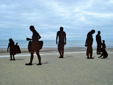
After a wander down to the small TI office on the harbour in the morning I was armed with a street map of a sculpture trail. There are more than 50 installations created in the last decade or so as part of an International Sculpture Symposium held every year.  So off I went, on the sea front the sculptures had a marine theme – shells and fishermen, in the streets above local characters, abstract objects and goats. The number of goat statues was puzzling until I read that the town was formally called Puerto de Cabras [goats] until it was thought in 1957 the new name [rosary] was more attractive. Several of the installations were on roundabouts making photography dangerous.  I called in at the museum based on the house where philosopher Miguel de Unamuno lived while in exile in 1924, I’d seen his statue in the hills yesterday. Next door was the simple Señora del Rosario church and that was it for tourism here. I regret not seeing the massive barracks of the Foreign Legion which was moved here in 1975 and apparently are still used on a smaller scale.

I only had my phone for the poor quality pictures.

Unamuno outside his house.

Senora del Rosario Church.

According to a well known review site two of the better restaurants on the Island are within a short distance of my hotel so I chose one for lunch. La Jaira de Demain lies up a side street above the harbour and is simply decorated with an outside terrace. I went for the menu – octopus and squid vinaigrette starter and than hake with mojo sauce for the main. Plus a sweet and wine 12euros.  Beautifully presented and delicious.

Needed a lie down on Playa Chico, the town’s beach, before my afternoon swim.

Later in the evening popped round the corner to El Bounty del Muella another small restaurant. Run by Italians the menu is Mediterranean/Canarian and is a little bit over the top presentation wise, I don’t like slate slabs to dine off. I chose ‘catch of the day’  grilled vieja [parrot fish] which was exceptionally tasty, an expensive end to my short stay on Fuerteventura.

LONGRIDGE FELL – UP AND DOWN DUDDEL BROOK FROM RIBCHESTER.


Oh, The grand old Duke of York,
He had ten thousand men;
He marched them up to the top of the hill,
And he marched them down again.

And when they were up, they were up,
And when they were down, they were down,
And when they were only half-way up,
They were neither up nor down.

Today’s walk followed that futile theme and the rhyme filled my head.

Duddel Brook rises quite high on the southern slopes of Longridge Fell and reaches the Ribble in Ribchester. This Brook has carved its way down the hill and created a wooded valley [seen on the OS map as a green caterpillar] for the most part secretive. The other obvious stream is Dean Brook passing through Hurst Green. Their importance in the past was related to the many small mills powered by the rushing waters and hence they are worthy of exploration today.

From near the Roman Museum in Ribchester, I set off along the Ribble to where the Duddel Brook issues close to a Roman bathhouse whose outline has been excavated. Normally field paths from Stone Bridge would lead across to Gallows Lane but at the moment they are virtually flooded so I followed the main road before turning up the Lane. A mullioned cottage at Lower Dutton is outstanding. I gained access to the brook a little higher and wandered through the beech woods alongside the water. An old mill appeared with signs of a mill race, lodge and ruined wheel installations. I believe that bobbin making was the main industry here but I may be wrong. Above the deep valley there was a brief view of Dutton Hall a prominent C17 house with a commanding aspect over the Ribble Valley. I crossed the brook on bridges and eventually deep in the valley recrossed by a shallow ford.

Start and finish – Duddel Brook entering the Ribble.

Roman Bath House.

Dutton Hall.
Wikipedia.

The path climbed away from the stream into fields. A lone oak tree, perhaps 300yrs old, was a waymarker across the field. On the road a small wholesale unit purveyed vitamins as well as ‘sweets’, I didn’t 

only half-way up – neither up nor down

  Again I took the easy drier tarmac option, walking up Huntington Hall Lane past several expensively converted houses and barns. After a steep section, Huntington Hall itself appeared on the right, a 17century house which has had a lot of money spent on it in recent years. At the road corner I was back into the fields with views back to the Ribble Valley, I meant to say this was a rare, sunny, dry day. Cresting a hill Intack Farm came into view, again a place spending lots of money with a horse arena right across the footpath but the diversion was no problem and well signed – but is it legal? A quick peep into Crowshaw Quarry showed it to be remarkably dry, could be bouldering here later this week. Crossing the road the main forest track was taken eventually leading up to the trig point on Longridge Fell. Chipping Vale and the Bowland Hills were fairly clear but that was not really today’s objective.

Huntingdon Hall.

Longridge Fell Trig Point.

when they were up, they were up


I came down by the track to Lennox Farm near where the Duddel Brook probably starts life.  A lane took me past Goodshaw Farm where the new lambs were being tended, the farmer told me he had 600 sheep to lamb this year and was concerned about the wet fields he was placing them into. Below the farm was an old barn, Smith Bottom, which on close inspection revealed two perfectly shaped cruck frames thus giving a clue to its medieval age. Down steeply through beech woods overgrown with rhododendrons to a bridge over our brook. This lane leads up to the highly secretive Dutton Manor in its cloak of trees.

A young Duddel Brook.

Smith Bottom cruck barn.

Trees hiding Dutton Manor.

Across the next road was Duddel Farm on its exposed hill. The farmer was feeding cattle in the barns and bemoaning the wet conditions, but despite that remained cheerful and chatty – we had many mutual friends and interests. He was right about the conditions as the next few fields leading back to Ribchester were almost afloat and the mud slowly crept above my knees.


I don’t normally take selfies.

I was keen to reach the last two listed buildings at Stydd. First was St. Saviours a simple C12 chapel. Its plane interior has a flagged floor with ancient gravestones, a stone coffin and wooden pulpit and rails. Very evocative. Further down the lane is Stydd Almshouse built in 1728 to house the poorest parishioners. It is an architectural gem with its central staircase and diminutive size.

St. Saviours.

So back to where I started.

when they were down, they were down


I would like the challenge of an entire ascent of Duddel Brook – obviously in dry summer conditions and with a good degree of so called trespassing. Watch this space.

BROCKHALL – OLD AND NEW.

Last week I attended the annual Chris Mayo Memorial Lecture hosted by our Bowland Pennine MRT, for whom Chris had been a doctor; always a sad occasion for me. I worked with Chris and he was a good friend. At the end of January 1993 I did a long walk in the Bowland Hills with Chris as part of my preparation for climbing Mount Kenya and Mount Kilimanjaro in the next month. Whilst I was abroad, and totally unknown to me, 45year old Chris, his 15yr old son Matthew, both from Longridge, and his 40 yr old brother from Edinburgh were killed in a tragic accident in Coire an Lochan in the Cairngorms. Long shall we remember them.
I am worn out from lots of tree felling and pruning in the garden and too many sessions at the climbing walls, its too wet and wild for anything else. So I needed a short relaxing walk at the weekend. Deciding to stay low and sheltered Mike and I headed for Old Langho in the Ribble Valley to explore the area around Brockhall Village. We parked next to the 16th century St. Leonard’s Church.This little sandstone chapel built  c1557 with stones coming from the recently dissolved Whalley Abbey, on the outside are several carved features from the abbey. We were lucky that the church was open, it no longer hosts services but is maintained by the charitable Churches Conservation Trust, so were able to investigate the inside features. Walking past the entrance to Brockhall Village, more of this later, we crossed fields outside Hacking Wood to reach the lane leading to Hacking Hall a grade1 listed early 17th century property. We had distant views of the massive hall with its mullioned windows and prominent garderobe. Closer at hand was Hacking Barn an interesting early Cruck  structure. The exterior has been much modified but the interior cruck trusses are impressive, the agricultural surrounds are a mess.

St.Leonards.

St.Leonard’s.

Hacking Hall.

Hacking Hall.

Cruck barn.

Cruck barn.

We next went down to the River Ribble just where the Calder joins from the south. The path downstream was washed away in parts and even today a large volume of water was charging down to Preston. A couple of canoeists were thoroughly enjoying their rapid transit. It was near here that there was a historic 17thcentury ferry and I believe an old wooden boat was in Clitheroe Museum. The house across the river was apparently occupied by the ferryman up to the 1950s.

Ribble/Calder confluence.

Ribble/Calder confluence.

Hacking Boat House, Kemple end behind.

Hacking Boat House, Kemple End behind.

At the end of Brockhall Wood, above the turbulent water of Jumbles Rocks,  we turned ‘inland’ towards the farm and former site of Brockhall Hospital. From 1904 to 1992 this functioned as one of Europe’s largest mental institutions. On its closure [care in the community!] a property developer Gerald Hitman bought the lease and developed a gated village of 400 properties. Blackburn Rovers have their extensive training grounds here, Mr Hitman also built his own contemporary home in extensive gardens, The Old Zoo. We skirted around the youth football fields and at the first road walked up into the village. On our left was the well secured Old Zoo but we spotted a lake, a few sculptures and a beech hedge maze, it would be fascinating to look around the grounds but I don’t know who now owns the property. The streets wandered through a variety of properties, a few adapted from the hospital buildings, many newish apartments and a scattering of architect designed detached mansions. There didn’t seem to be much soul to the village, no obvious shop or pub, commuting hell or heaven? On the way out through the permanently manned barriers, to keep out the riff raff, we passed an upmarket restaurant next to the modern Rover’s training facilities.

How times have changed here.

Hospital conversion.

Hospital conversion.

Hospital cottage.

Hospital cottage.

More upmarket.

More upmarket.

Oh! for a peek.

Oh! for a peek.

Rusty Rover.

Rusty Rover.

A weekend walking by water.

One can’t always be in exotic areas, Lancashire is enough. Mel was up for a few days, my planning had been delayed by other arrangements, so on the hoof we enjoyed the following days.

Thursday. 11.30 Pick up at Preston station .                                                                                     12.00 lunch at the five star RK Sweet Centre – masala dhosa £2.50.

14.00 a walk around the reservoirs in Longridge visiting the shops to purchase delicacies and drink for tonight’s home cooked Italian meal.

Longridge reservoir.

A Longridge reservoir.

Friday. A late start saw us in a compulsory Chinese buffet in Southport.

After the Egyptian Room in the Atkinson Gallery we spent time looking at the eclectic historical exhibits relating to the Sefton coast –  lifeboats, Bootle Docks, shrimping, Dan Dare, Meccano.

On the spur of the moment we drove down the coast to Crosby to view Antony Gormley’s ‘Time and Space’. It was mid tide so the figures ranged from full bodies to heads barely visible in the sea.

Crosby beach.

Crosby beach.

Saturday. Another late start, shan’t tell you why, and we were following the Ribble Link canal towards the Ribble. We didn’t go all the way but cut across a golf course to the Lancaster Canal which we followed back towards Preston, stopping off at a cafe in the UCLAN sports ground. We skirted Haslam Park and continued along the surprisingly green route into the centre of Preston where goods from the canal were transferred to trams to cross the river and join up with the Leeds/Liverpool canal. The modern Ribble Link strives to do the same but I wonder how many boats use this facility.     A glorious sunny day.

Lancaster Canal in Preston.

Lancaster Canal in Preston.

End of the line in Preston.

End of the canal in Preston.

The excellent  Egyptian cafe in Preston provided food as good as Cairo in the evening.

Sunday. The weather remained good. Another ‘watery’ walk, taking in Cockersand Abbey, coastal walking, Glasson Dock, another canal and Thurnham Hall, was enjoyed in the sunshine.

Cockersand Abbey.

Cockersand Abbey.

Glasson estuary with the damaged Plover Scar light.

Glasson estuary with the damaged Plover Scar light.

Glasson Dock.

Glasson Dock.

Link canal with Bowland Fells in the distance.

Link canal with Bowland Fells in the distance.

Back home it was time for an ‘Indian’.

Monday. Take Mel back to the station until we meet again next Spring on the Thames Way for some more ‘watery’ walking.

http://www.rksweets.com/

http://www.gourmethouserestaurant.co.uk/

http://www.theatkinson.co.uk/

http://www.lolaegyptiancuisine.co.uk/

http://www.hamadanrestaurantlongridge.co.uk/

NORTH WALES PATH – Day 4.

Rhos to Kinmel Bay. Highs and lows.

That should really be ‘lows and highs’ as I started the day on the front at Colwyn Bay, all a bit drab with its disused pier, overwhelming concrete and lack of facilities. Very few people ventured onto the sands. A poster probably reflecting the fading past. There was however a stunning art work of metal figures.I must have switched off walking along the bay as I went past the inland diversion and had to retrace to find paths up ‘Fairy Glen’, a green corridor following a stream up through Old Colwyn. This gave a chance for a break as I passed the high street. Old style, no frills, Gillian’s Kitchen – coffee and toasted teacake for £1.70, long may these places survive. Back into the glen to climb higher.  The next couple of hours passed in a different world in the hills around Llysfaen. I wandered through golf courses, untracked woodlands, village lanes with tiny cottages, open meadows and limestone escarpment. To be honest I felt lost most of the time, could have done with a 1:25,000 map, but I somehow stayed on the NWP as I kept coming across the infrequent waymarks. All the while there were views across the rolling countryside.  Don’t think many people venture up here. I eventually returned to the coast through an arch of a public house, The Valentine, in Llanddulas. The inn sign gives the wrong impression as the pub is really named after Lewis Valentine [born in Llanddulas] one of the founding members of Plaid Cymru. Then it was back on the coastal walkway/cycleway for 5 miles. The start wasn’t so bad at Abergele, I even found a fairly civilised cafe for beans on toast and a pot of tea. But from then on it was a continuous line of drab caravan parks separated from the beach by the railway. The wind farms out at sea didn’t seem over-intrusive in these surroundings. The few people braving the beach were huddled out of the wind, an epitome of English seaside holiday. As were the passing families with beefburgers, candy floss and cans of beer. The obese amongst these seem to have devised a certain ‘waddle’ to progress, much in evidence. I’m sure I looked just as strange to them with my boots and walking poles. Nobody stopped to chat. From time to time  screaming above the sound of  pop music announced a mini fun fair. Having said all that there were always extensive views; back to the Ormes and forward to the hills dropping to Prestatyn, the end of the NWP.There were a few passing aspects to improve my mood… I’d had enough at Kinmel Bay and found my way through a new marina to the River Clwyd where I’ll start tomorrow. Reflecting now this was a quite a varied days walking.


THE LANCASHIRE WITCHES WALK – Caton Moor to Lancaster Castle.

Our final stage of this fascinating walk began high on the Caton Moors. The well known, when  viewed from the motorway, wind turbines were rotating rapidly in the strong wind as we passed. Up here today we had extensive views of the Bowland Fells, Ingleborough and Pennine fells north, the Lune Valley and Morecambe Bay, an exhilarating start to the day. In a picnic area we found our first tercet of the day, No 6. A lane coming from nowhere brought us down into Brookhouse and we explored the back lanes and pretty houses of the village, roses seem to be a specialty of the gardens here.

Across the main road we joined the Lune Valley Ramble into Lancaster along an old railway. All of a sudden humanity appeared – dog walkers, joggers and cyclists supporting the idea of good exercise and being able to participate in a safe and beautiful environment. Well done Lancaster with the help of European money!  Two men were setting off  cycling coast to coast  to Bridlington, a route my son speaks highly of. They were an odd couple one young and fit on a classy bike, the other hoping to rely on his electric motor to get across the Pennines. I hope their enthusiasm saw them through although I suspect they will have been very wet at the weekend. We crossed the famous Crook Of Lune [painted by Turner] on an impressive bridge. More cyclists were passing the next tercet. For a break we sat on the banks of the river below a weir near Halton old station. A fisherman engaged us in conversation about all things Lancashire, No fish were caught. it was about at this time that the zip on Sir Hugh’s shorts malfunctioned causing great hilarity to the fisherman and great embarrassment to the wearer. Apologies to anyone in Lancaster whom we shocked or offended.

A pleasant stretch on a lane parallel to the motorway followed, large puddles where evidence of recent rainfall. We were heading for the castle but first we visited the prominent hill forming part of Williamson Park thought to be the site of the witches’ gallows, and now the site of the 9th tercet.  We wandered through attractive parkland and climbed up the baroque Ashton Memorial for views over Lancaster and the surrounding areas. Then it was down busy streets across town passing the Golden Lion pub where the witches were supposed to have been offered a final drink on the way to be hung – an unlikely tale. Incongruously two walkers in shorts, with walking poles, marched through the shopping area and eventually climbed up to the impressive castle gates and the last tercet. A lot of restoration work is going on so we didn’t linger.

Thus we had completed a trail full of interest which deserves to be better known.

The complete poem

‘The Lancashire Witches’ by Carol Ann Duffy

One voice for ten dragged this way once
by superstition, ignorance.
Thou shalt not suffer a witch to live.

Witch: female, cunning, manless, old,
daughter of such, of evil faith;
in the murk of Pendle Hill, a crone.

Here, heavy storm-clouds, ill-will brewed,
over fields, fells, farms, blighted woods.
On the wind’s breath, curse of crow and rook.

From poverty, no poetry
but weird spells, half-prayer, half-threat;
sharp pins in the little dolls of death.

At daylight’s gate, the things we fear                                                                                               darken and form. That tree, that rock,
a slattern’s shape with the devil’s dog.

Something upholds us in its palm-
landscape, history, place and time-
and, above, the same old witness moon

below which Demdike, Chattox, shrieked,
like hags, unloved, an underclass,
badly fed, unwell. Their eyes were red.

But that was then- when difference
made ghouls of neighbours; child beggars                                                                                              feral, filthy, threatened in their cowls.

Grim skies, the grey remorse of rain;
sunset’s crimson shame; four seasons,
centuries, turning, in Lancashire,

away from Castle, Jury, Judge,
huge crowd, rough rope, short drop, no grave
only future tourists who might grieve.

Sir Hugh’s own blog tells a similar tale of our progress –  http://conradwalks.blogspot.co.uk/

THE LANCASHIRE WITCHES WALK – Clitheroe to Slaidburn.

The scenery changes today as we leave the Ribble Valley and climb into the Bowland Hills. Rain is forecast and its rather dull in Clitheroe. Canoeists float downstream as we cross the river at Brungerley Bridge  and a group of youngsters are on the field path learning navigation.  We soon leave them behind and cross fields around Waddington, most of the farms/barns look hundreds of years old but many have had expensive makeovers.  Looking back Pendle Hill is in cloud. The hay meadows we pass through are full of flowers and brighten up a dull day. I have a painting at home representing the same scene. As we climb onto the moor on a drove road we realise we have been here together before whilst exploring Easington Fell last winter.There are no views today in the low cloud which is a shame as this is a wild and desolate moor. On the map are marked The Wife and Old Ned but they turn out to be disappointing piles of stones. A good track, presumably shooting, takes us down the fell to a shooting lodge marked as Fell Side. Dogs are caged up and greet us excitedly. At the moment we arrive the rain starts so we are lucky to find shelter and tables outside the lodge, lunch is taken. On the approach I had stuck my walking pole under a stone and a metal trap snapped shut almost breaking it, I couldn’t imagine what it could do to fingers. What are they trying to catch? Our lunchtime was enlivened by a ‘turkey’ parading about in front of the windows. The rain stopped and we continued on our way over a hill and down into Slaidburn, usually seen with a backdrop of Bowland Fells, but not today. Our tercet was in the carpark. The village was busy hosting a small steam fair which kept us entertained for awhile though the crowds and vehicles detractied from the normal tranquility of this lovely village. Familiar paths through woods and then open fields gained height, Curlews and Lapwings became a constant sight and sound. On past a graveyard for farming implements which looked like a ‘herd’ of dinosaurs across the land. We finished the day under the Bowland Fells just before the start of Roman Road over Salter Fell. We will want better visibility for that next section.


.


THE LANCASHIRE WITCHES WALK – Higham to Clitheroe.

An interesting day’s walk.

Delightful walking through farmland started the day from Higham. We passed several old farmhouses with mullioned windows and in the distance saw an unusual Gothic feeding shed [on the Huntroyde estate]

DSC01983

The next estate we entered was Read Hall, the walk goes through converted stables and into the parkland next to the rebuilt hall. Its owner in 1612 was Roger Nowell the magistrate who sent the witches to trial at Lancaster. Under Pendle Hill we followed bridleways which may well have been the actual route taken by the carts used to transport the captured witches. We diverted to Spring Wood to view our third tercet.

 Read Hall parkland.

Read Hall parkland.


On arriving at Wiswell we found a hidden pub, Freemasons Arms, and enjoyed a relaxing drink in its cosy bar. The village was a delight to explore with its alleys, stone cottages and neat gardens.

As we wandered through fields towards Clitheroe the sky was blackening over Pendle Hill and before long we were in a brief thunder storm.

Darkening skies.

Darkening skies.


Clitheroe is dominated by its castle and we spent time exploring. In the castle grounds was an ornamental turret, 1850, removed from the parapet of The Houses of Parliament and presented to the Borough of Clitheroe in 1937. Strange. We collected our 4th tercet and finished the day in sunshine at the parish church.


THE LANCASHIRE WITCHES WALK – Barrowford to Higham.

It was a hot morning when Sir Hugh and I parked up next to the Heritage Centre in Barrowford, the start of The Lancashire Witches Walk. Having  found the first tercet installment with its verse and witches’ name we set off through the alleys and cobbled back streets and were pleasantly surprised by the hidden beauty of the town. There were many reminders of its industrial past and we contemplated the human movement to and from the mills on the footpaths we were following today. Soon we were out into rural Lancashire at its best, undulating tracks between small stone built hamlets, over fields and alongside sparkling streams. On arriving in Barley we suddenly collided with mass tourism alongside Pendle Water – more Blackpool than countryside. Somehow we missed the cafe.  Then we were climbing away and passing the presumed site of  Malkin Tower, home of the Demdike family, a ruined hillside farm. .The next hour passed pleasantly but aimlessly circling round Lower Ogden Reservoir passing another tercet.  We ate lunch in the shade high above Newchurch in Pendle. Once in the village the Witches Galore gift shop had to be visited stocking everything from tacky witches to learned books, The lady owner had been there for 30 years and was a wealth of knowledge.  Sir Hugh emerged with a witch to scare his granddaughter and I another black cat, Impulsive shoppers. On a more cultural note we visited the church with its ‘eye of God’ to ward off evil spirits.  I was keen to visit the nearby Faughs Quarry where I’d climbed in the past and where there is a carved face in the rock, ?created by one of the quarry-men. Up to the ridge, Rigg of England, with good views, and then down to the village of Fence where the pub is closed and new housing is taking over.

Old house in Fence.

Old house in Fence.

Along the main road Ashlar House was passed, here some of the witches were questioned by local magistrates in 1612. The route onwards through  Lower White Lee farm was not helpfully waymarked and we had the impression they didn’t want walkers on their land. We finished in Higham with its prominent pub, Four Alls Inn, where one of the  witches, “Chattox” was accused of turning the beer sour  and bewitching the landlord’s son!

A good start to our walk with varied scenery and interesting history.


THE LANCASHIRE WITCHES WALK – pre ramble.

The Pendle district of Lancashire is infamous for its history of witches. Back in the 15-16th centuries witches made a living from herbal remedies, bone-setting and midwifery [humans and animals] and dabbled in curses and spells.  Usually single women they lived on the edges of society. Things came to a head in April 1612 when Alizon Device, a Demdike,  had an argument with a pedlar and he suffered what was probably a stoke. The landed gentry, who were also the magistrates, were keen to support the monarchy, James 1st who was opposed to ‘witchcraft’ and hoping to put themselves in a good light saw an opportunity to prosecute Alizon. Things then became complicated as other families, such as Chattox, were embroiled in the plots. Eventually twenty local ‘witches’  were arrested and brought before the magistrates and taken to Lancaster Castle for trial. Ten were hung in August of that year. Over the years a great deal of folklore has developed from this story. The walk, to coincide with the 400th anniversary of the events, was designed to follow roughly the route from Pendle to Lancaster and include some notable locations. Alongside this again to celebrate the 400 years  the poet laureate, Carol Ann Duffy, has written a poem in ten tercets to comment on the proceedings. To reflect the poem 10 cast iron installations  have been placed along the route each with a tercet from the poem and the name of a witch.


‘The Lancashire Witches’ by Carol Ann Duffy

One voice for ten dragged this way once
by superstition, ignorance.
Thou shalt not suffer a witch to live.

Witch: female, cunning, manless, old,
daughter of such, of evil faith;
in the murk of Pendle Hill, a crone.

Here, heavy storm-clouds, ill-will brewed,
over fields, fells, farms, blighted woods.
On the wind’s breath, curse of crow and rook.

From poverty, no poetry
but weird spells, half-prayer, half-threat;
sharp pins in the little dolls of death.

At daylight’s gate, the things we fear                                                                                               darken and form. That tree, that rock,
a slattern’s shape with the devil’s dog.

Something upholds us in its palm-
landscape, history, place and time-
and, above, the same old witness moon

below which Demdike, Chattox, shrieked,
like hags, unloved, an underclass,
badly fed, unwell. Their eyes were red.

But that was then- when difference
made ghouls of neighbours; child beggars                                                                                              feral, filthy, threatened in their cowls.

Grim skies, the grey remorse of rain;
sunset’s crimson shame; four seasons,
centuries, turning, in Lancashire,

away from Castle, Jury, Judge,
huge crowd, rough rope, short drop, no grave
only future tourists who might grieve.

The walk is 51miles long and divides neatly into 5 sections, which being relatively short would give us time to explore. Following on from our successful Wainwright’s Outliers venture Sir Hugh and I have joined forces to complete the walk which is fairly local to both of us. This also will facilitate car sharing logistics for daily ventures. The path has been well waymarked and much of the scenery will have changed little in the 400 years.

There are a couple of guide books available as well as a wealth of information on the web.

The Lancashire Witches Walk Guide.   Ian Thornton-Bryar  and  John Sparshatt, who developed the route.

The Lancashire Witches Walk.   Sue and Peter Flowers, Artistic Directors of Green Close who developed the Lancashire Witches 400 program and involved the various artists and Carol Duffy.

THE THAMES PATH – day 8. A short loop, then back to Oxford.

Abingdon to Clifton Hampden.

By the time we arrived at Clifton Hampden we weren’t that far from Abingdon as the crow flies and were able to catch a bus back. This was the end of our week, the walking has been great and we intend to return to continue sometime in the future.

As I mentioned yesterday Abingdon is full of interest and it was maintained as we left the town bridge on the opposite bank of the Thames. Dog walkers were out in force and we met the lady walker using a boat and husband for backup – she must have been walking at our pace. We were soon in a very rural environment and enjoying the solitude, kites and buzzards were wheeling overhead.


Pleasant Abingdon living.

Pleasant Abingdon living.

Rural Thames.

Rural Thames.

A couple of locks gave us breaks and before long the elegant brick bridge at Clifton came into view.Our main objective before leaving the trail was a celebratory pint in the adjacent Barley Mow. The pub itself was a bit disappointing, as one customer asked  “where is the River?”,  but the beer garden was pleasant enough for a relaxing  drink. Looking back over the week I think quite a few of the riverside pubs have been over-hyped and overpriced, but you come to expect that in the Thames Valley. The village consisted of thatched cottages and a bus whisked us back to Abingdon and on to Oxford. Mel caught a train back home whilst I had time to look around Oxford. First I wanted somewhere to leave my luggage, train and bus stations no longer provide facilities but I found Oxford Backpackers Hostel did for a modest fee, well done them. I wandered without a map amongst the colleges, all of the famous names, and relaxed in the parks. Cycles were everywhere. Very few English voices were heard amongst the tourists or students. DSC01709

Spot the Gormley.

Spot the Gormley.

That was Oxford.

I just caught the last connecting train to Preston.


THE THAMES PATH – day 7. A busy stretch.

Oxford to Abingdon.

We were on the towpath fairly early on Sunday morning soon passing the classic Christchurch meadows on the opposite bank.  Already the river was full of cox-less fours and coxed eights, all being coached from the towpath by kamikaze trainers on bicycles. Each Oxford college has its own boathouse along this stretch. A significant number of runners were also pounding along, presumably college folk.

We also started to come across orange vested walkers staggering past us  with glazed eyes fixed on an end in Oxford. These brave people had set out from London yesterday at 8am and had walked day and night to get here 60 odd miles up the Thames. Heartbeat, the British Heart Foundation, will have benefited from their exertions.

There were various checkpoints for the walkers and backup from the Southern version of Mountain Rescue .

Sat by the lock at Sandford we were admiring a canal barge when the guy on board engaged us in conversation – ex-army with post traumatic stress he had been finding life difficult so bought the boat to live on for a life change. He had picked it up in Blackburn and had spent several weeks getting to here on the way to the Kent and Avon.  He regaled us with stories of travelling through the locks of the industrial towns and attacks from the local youths who see canal boats as a soft target. Best of luck to him.

We were flagging in the heat when we saw a poster for an art/coffee stop in the modern Radley College boat house. As part of an Oxfordshire art week the upper room had been set up as a gallery and coffee shop run by the lady artists themselves. A perfect place for a break and chat on the balcony looking out over the river.

On the opposite bank was the more romantic boat house of Nuneham House.

There were a lot of expensive riverside properties … … even this is probably out of our price range …As we approached the busy Abingdon Lock more and more Sunday strollers appeared  using local paths and riverbank.

Abingdon Lock.

Abingdon Lock.

Riverside Abingdon itself was an interesting old town to explore.


THE THAMES PATH – day 6. Dreaming of Spires.

Bablock Hythe to Oxford.

Unfortunately the ferry has gone which would have linked to the old towpath, the old winch is still there, instead soulless ‘caravan’ parks forced us away from the river for a couple of miles.

The rural walking was pleasant enough. Today’s walk encounter was a lady trail runner and her dog who passed us on her way to Abingdon, she had time to chat despite doing 20miles. We leisurely reached the river near Pinkhill wear and lock which was busy with pleasure craft. Hedged paths gave a change of scenery onwards to Swinford lock.where a stag party outing in sailor and pirate dress were abandoning there barge which was taking in water and listing, everyone survived.

More uncultivated meadows followed but unfortunately the only wildlife we saw were geese. Interestingly the banks were littered with opened fresh water mussels presumably by geese and ducks.

The noise of the approaching dual carriage way brought us back to civilization. Then it was over a bridge to the waterside Trout Inn which was packed despite the poor weather. Is it the setting, the good food or the Inspector Morse connection that draws people here. Despite only having one pint I managed to leave my sticks in the bar, we were well on the way to Oxford before I realised. This gave me the chance to view the ruined 17th century Godstow Abbey three times. Rain began for the first time as we followed the popular path towards those just visible Oxford spires. On the opposite bank was Port Meadow which has never been ploughed having been presented to Oxford by William the Conqueror.

Police activity in the street of our inn for the night had us worried, there was a cordoned off area as a ‘dangerous’ object was removed. The inn was packed with people unable to return home. We heard later it was a WW2 bomb. This was more exciting than the cup-final on TV.

We couldn’t understand the menu in the Korean restaurant visited but enjoyed an enjoyable meal, but I suspected most of the staff were in fact Chinese.   Back at our inn the beer was good but the accommodation dire.

I will return to look around Oxford on the way home.


THE THAMES PATH – day 4. Easy strolling.

Lechlade to Tadpole Bridge.

Today we have an easy stroll through through the flood meadows of the upper Thames.

Shortly after leaving Lechlade the first lock and weir are encountered, St. John’s. The Thames’ locks were constructed from the 17th century onwards and improved  navigation.  An increasing number of pleasure boats were moored up from now on but few were travelling.St. Johns Lock with Lechlade church behind.There is statue to Old Father Thames at St. John’s, originally designed for the Old Crystal Palace in 1854, moved to the source in 1958 and to its present position in 1974.

In the  next couple of miles the river meandered wildly. A common sight were WW2 pillboxes built to defend the Thames if an invasion occurred, they were all in good condition.

Another feature to keep recurring was wooden footbridges of a standard design linking fields and lanes across the river. These bridges were built to replace old demolished wears and have been themselves replaced over the years.

We diverted to the pretty village of Kelmscott where the Manor had been a home of William Morris, but unfortunately it was closed today. We grabbed a drink at the  upmarket Plough Inn which looked expensive for food.

'Arts and Crafts' in Kelmscott.

‘Arts and Crafts’ in Kelmscott.

Back on the river we walked through meadows with extensive open vistas. Buscot, Grafton, Radcot and Rushey Locks were all passed and appreciated, usually a seat was provided and water available. A feature of the locks were the lock keepers’ cottages with their tidy gardens, volunteers help out the Environmental Agency. Delightful places to  watch the river’s activities, they became a highlight of the walk eagerly looked forward to. The weirs enabling the river to flow past the locks all looked very high-tech.

Grafton Lock.

Grafton Lock.

A modern Weir.

A modern Weir.

Another wooden bridge.

Another wooden bridge.

Tadpole Bridge and The Trout Inn, one of many so named on the river, were easily reached marking the end of today’s stroll. The Inn was fully booked so using a taxi we had another night in the pleasant New Inn at Lechlade.


10 “TOP THINGS” I SAW IN UZBEKISTAN.

I have had an image of the ancient trading city of Samarkand in my mind dating from my fascination with geography as a child when I would  pour over pictures of the world in encyclopedias [the internet of the 50’s]. This was reinforced about 20years ago when I attended a lecture in Manchester from a bloke who had spent 6 months travelling the Silk Road  in the steps of Marco Polo. He hailed from Macclesfield and eventually arrived at the silk worm farm in China which supplied the local Cheshire silk weaving mill with the raw material. The lecture was a fascinating insight into his own adventures along the way as well as a portrait of the Silk Road and all its famous cities. So when some friends were organising a trip earlier last year I jumped at the chance of visiting this largely unknown country and the cities of Tashkent, Khiva, Bukhara and Samarkand. I’ve just realised I never published the post and have been prompted by a new series on BBC4.  So in no particular order ……….. Continue reading

THE THAMES PATH – day 3. Contrasts.

Cricklade to Lechlade.

From Cricklade we followed the still small river, now supposedly navigable ?canoes only. Damsel flies proved difficult to photo and other flies were being devoured by low flying swifts.

We arrived at Castle Eaton just in time for a coffee in the delightful Red Lion.  From here the Thames Path is away from the river keeping to quiet lanes and tracks, enlivened by abundant Cow Parsley and the pungent aroma of Hawthorn [May]  blossom .  Cuckoos were making themselves heard.  It was on this stretch we met two interesting characters. One was virtually running holding an umbrella to fend off the showers. He turned out to be from Cumbria doing the Path in rapid lightweight fashion with his wife’s back up. The logo on his umbrella, LDWA, maybe explained his speed. The other chap, who we had more time to talk to, was the archetypal hardened backpacker. A straggly grey beard, a large rucksack with dangling appendages and a wealth of knowledge, he was busy getting water out of the river to filter!  We look forward to further meetings with the tortoise and the hare.


For reasons unknown there is no access to a long stretch of the Thames hereabouts (seeing some of the expensive property I can guess why) and one is forced to walk along the verge of a busy fast road for almost a mile. A disgrace for a National Trail.

At Inglesham however there is St.John the Baptist church, what a treasure. A medieval church saved from 19th century ‘improvement‘ by William Morris. The interior is centuries old with wooden box pews and medieval wall paintings and inscriptions. A unique example of times gone by.


Also at  Inglesham the redundant Thames and Severn Canal leaves the river near The Round House, Several round houses were built on this canal for the lock-keepers – horses were stabled on the ground floor with people living above. As we proceed boats start appearing  and the  river takes on a busier character.

Round House Farm.

Round House Farm.

Approaching Lechlade.

Approaching Lechlade.

Lechlade, another old market town, is reached by leaving the Thames Path at Halfpenny Bridge, a lovely old stone toll bridge still with its small toll house.
It tried to rain several times today.


A Saturday afternoon stroll out of Preston.

I’ve lived in the Preston area for over 40 years but never been into Haslam Park. That was rectified this weekend, my friend Mike was researching a short walk for his walking group and thought the park and adjoining canals would be suitable.

The Preston City Council website says –

Formerly open pastureland, Haslam Park was donated to the Borough by Mary Haslam in 1910. She commissioned the parks design and construction in memory of her father, John Haslam, who was the owner of a cotton mill on Parker Street, Preston. Miss Haslam’s main ambition for the park was to ensure that ample space was made for the children, and to this end she donated additional money for the development of the park. From this generous donation landscape designer (or garden architect as he preferred) Thomas H Mawson was contacted. From his designs the park was finished and opened in 1912.

The historic features from this design include wrought iron entrance gates (these were restored in 1999 with a grant from the Heritage Lottery Fund), an avenue of lime trees, cast iron drinking fountain (this no longer works) and the lake and cascade from the Lancaster canal, still a popular part of the park. Also included in the original design was an arboretum and grass lands to encourage wildlife and flowers.

In 1915, Mawson amended his plans to include swimming baths, but due to the lack of funds and the First World War the plans were shelved. The baths were constructed in 1932 when Mr J Ward donated money for the baths and an aviary. Sadly both of these features no longer exist with the baths closing in 1987 and subsequently demolished.

We set off down that lime tree avenue past the drinking fountain and onto the Lancaster Canal. This was a quiet stretch with not much boat activity, in fact none at all. Walking past the ‘new’ town of Cottam we realised development was still proceeding at a pace, pity the local roads.

Canal towpath, quiet lanes and a golf course saw us onto the Ribble Link, a new navigation linking the  Lancaster Canal to the River Ribble and hence into the national network. It was opened in July 2002 but has had several closures due to flood damage and the need for dredging. I wonder how much use it gets.

At the basin connecting to the Lancaster Canal there are steep locks and a strange statue.

We completed a 4 mile or so circuit just as the rain started again. A short walk a short post.

Not the GR131 GRAN CANARIA – Festival time.

Hoya Pineda – Galdar and onwards.

As you can imagine we had a slow leisurely start to the day, dragging ourselves away from the Hostel we climbed back up into the village and contoured round the west side of the mountain. Walking through the village dump we found a path under steep basalt cliffs and height was slowly lost. Over to the west were the steep Tamadaba hills and ahead the volcanic cone above Galdar.

Lanes were met and led us past dog infested houses to St.Maria de Guia, a pleasant little town with supposedly an area of historic houses. We were sidetracked by a car rally in the plaza. The narrow streets, cobbled with black volcanic rock, and old houses in the higher part of town were  explored. What struck us most was the height of the doors in proportion to the properties. Why?  The area is also famous for its Queso de Flor de Guia made mainly from sheep’s milk curdled with Cardoon [thistle] flowers. We found ourselves in the courtyard of a house selling this and opted for a taster of three cheeses and wine. The cheese was salty and served with a biscuit like bread, I wasn’t that impressed. However the olives we ate were some of the tastiest I’ve ever had and the ambience in the hot sun perfect.

Galdar is a stone’s throw away across the motorway. Some of its houses seem precariously built on the side of the volcanic cone. We found our way to the Santiago church and walked into the local festival, marching bands, fancy dress, dancing troops and a very loud pop concert. It was a couple of blocks away before we found a quiet café for a drink.

Galdar.

                                                               Galdar.

Santiago Church.

Santiago Church.

The Guagua [local bus] soon had us into the capital, Las Palmas, for a couple of days relaxation exploring the old town with more festivities, unusual modern art galleries, tropical gardens, lovely beach, fish restaurants, local backstreet bars…………… All a distant memory now we are back in the good old UK.

THREE-IN-ONE – a fulfilling weekend.

It’s that period of the year again, the leaves are turning and the evenings darkening, and it’s time for the annual autumn visit from my old mate Mel.

[ See previous posts to get an idea of what we get up to. —

Walking the Calories off??

https://bowlandclimber.com/2013/11/16/a-busy-weekend-a-long-post-of-short-walks-art-and-restaurants/ ]

His wife packs his thermals and sends him up North. This year however we are blessed with warm and calm weather so were able to make the best of his visit.

In brief we ate an Uzbek banquet [haven’t posted about my trip to Uzbekistan yet],  a couple of local restaurant curries, a take away Chinese and some bar snacks.

Uzbeck banquet.

Uzbek banquet.

Thankfully interspersed were three good and variable outdoor days’ exercise.

1. The Yorkshire Sculpture Park.

A long drive over to Wakefield and we arrived at Bretton Hall whose stately grounds act as the backdrop to the YSP,  I’ve been meaning to come here for ages. Hepworth,  Gormley, Goldsworthy,  Moore,  Miro,  Caro, Frink …  they are all here and many many more. A real feast for the senses. We wandered around the grounds in beautiful sunshine like two kids in a sweet shop, new discoveries round every corner.SAM_6069One cannot see everything in one visit and I’ll have to do a separate post on the YSP soon. We were lucky that the spectacular Cummins/Piper ‘Poppy Wave’ installation [from London] was in the park and attracting a lot of visitors.Another stroke of luck was the opening today of several video installations from Bill Viola, these powerful visualisations explore the human condition in a unique way using light and water. The Chapel and the Underground Gallery where they are staged seem to be perfect locations. This show is on until April  – a reason in itself to visit the park. Try this video for an impression of Viola’s work….

2. Fairy Steps Limestone / Dallam Deer Park.

We met up with Conrad [http://conradwalks.blogspot.com/] at Milnthorpe for one of my favourite short walks on a promising morning. The tide was out as we climbed away from the Kent sand banks. I was keen to revisit a fascinating area of water-eroded limestone above the large quarry. From there we followed delightful woodland paths to the Fairy Steps – a cleft in the escarpment in which legend says if you don’t touch the sides the ‘fairy’ grants a wish, fat chance; excuse the pun. Down to the 16th -century coaching inn The Wheatsheaf in Beetham for a light bar-snack and a pint of Wainwrights. Dallied in the working 18th-century Heron Corn Mill and strolled through the manicured Dallam Tower deer park. A perfect walk in miniature.

3. Walking Preston Guild Wheel and Brockholes Reserve.

Making use of local buses we were able to walk a segment of the Guild Wheel. As we walked down the road to the Crematorium I think Mel had his doubts but we were soon into woodland above the Ribble. Next was the extensive Brockholes Reserve, created from worked out sand pits which has become a local favourite since opening four years ago. We didn’t have time for a full exploration but made use of the ‘floating’ visitor centre for a cup of coffee overlooking the lake and reed-beds. A coot was feeding directly in front of us and proved difficult to photo in half dive. I will have to return here more often this winter to appreciate the wildlife and visit the hides. Up to now we had seen few people but from now on there was a steady stream of cyclists using the path in both directions and enjoying the sunny weather. Level walking alongside the River Ribble and on into the outskirts of Preston. Avenham and Miller Parks have been much improved in recent years and are a credit to the town. Cyclists were flocking to the new pavilion for sustenance. We just kept walking and were soon into the regenerated Docklands area. The Marina cafe served good coffee and we called it a day catching a bus up to town and then one back to our starting point. I’ve ridden the 21miles of the  Guild Wheel several times but now realise how easy it is to walk segments using the radial buses, you certainly see more walking.

KING LUDWIG WAY 8 – bits and pieces.

Now that I’m back and sorting through my photos, I have a few more observations to make on the King Ludwig Way and the area in general. Bavaria is a unique region,

In no particular order……….

1. Guide Book. A new one is needed to enthuse us Brits to visit this area. Mine was from 1987, although not much has changed since then. The walk is undulating but not strenuous. It is full of fascinating sights in a lovely corner of Germany – would suit the casual walker, as there is ample opportunity for accommodation and refreshment.

2. Waymarking and signs. The waymarking has been updated recently, and you will never get seriously lost.

Old sign.

Old sign.  


New sign.

New sign.


There are a multitude of routes.

3. Cycling. If you don’t fancy walking, there is an alternative cycling route. Cycling is big in these parts – it’s fairly flat and there are lots of signed cycling routes on virtually traffic-free lanes. In any case, cycling is far more popular and catered for in Germany than in Britain. Everyone does it, and they start at a young age.

4. Maypoles and births. Every village seemed to have a tall, blue-and-white-striped maypole, whose decorations usually reflected the area’s history or commerce. Presumably, they feature in May festivities. Also of a similar celebratory nature is another common sight – signs outside houses where there has obviously been a recent family addition, a nice touch.

5. Painted houses. Many of the houses in the villages have painted motifs on their walls. In most cases, these are motifs reflecting and emphasising the architecture or nature of the building, but in some cases, an actual picture has been painted on a wall. Must make redecorating hell. I saw two ‘wall painters’ in Fussen, but they were having a fag break, so no action photo

Clever decoration.

Clever decoration.


A house wall painting commemorating   closed coal mines.

A house wall painting commemorating closed coal mines.

6. Log piles. These are everywhere, from the forests to the villages. People go to lengths to have the tidiest winter log piles next to their houses. They become almost an art form – what about ‘a crate for the Tate’

7. Language. Ashamed I didn’t get to grips with this – next time.

How was I to know.....

How was I to know…..

What about all those long words …I even had difficulty hearing what greetings passing people gave me, I only fully understood when a welcoming village road sign spelt it out – Gruss Gott.

8. Taps and water-troughs. Often coinciding with a pilgrim’s route, linking churches and shrines, there are plenty of watering points. This one caught my eye ..

9. Best Flowers in Show. The winner was a house in Diessen, but I don’t know why I didn’t take a picture of it.   The Runner up was…

10. Pillows. I will miss those lovely, soft pillows and duvets.